Five Mile Creek
Explore Five Mile Creek near Cardwell with the Townsville Bushwalking Club. A two-day hike of rock hopping, gorges, boulder scrambles, swimming holes and a 70 m waterfall, offering rugged terrain and scenic rainforest adventure north of Townsville.
16-17 November 2013 - two day activity.
Five Mile Creek is located seven km south (highway crossing) of Cardwell. 160 km drive north of Townsville.
Saturday
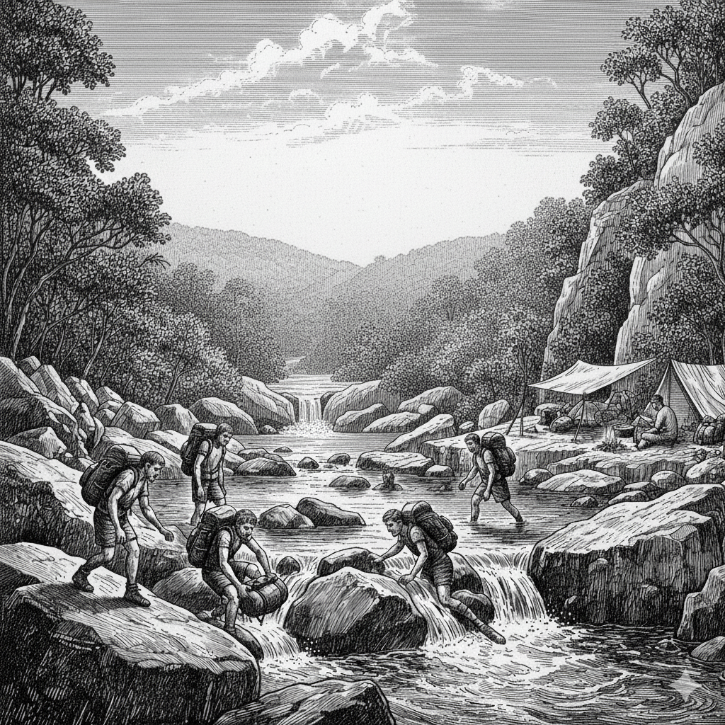
Two cars with four pax departed TVL 06:50 am, arrived Five Mile Ck Road junction 08:35 am and met the three Cardwell members at this junction. “Where are the TVL ladies?’ was the Cardwell question, noticing only blokes from TVL – “Does this mean it is a very hard walk?”. Convoy down Five Mile Creek Road into the property where we start the walk from. Quick chat with the owner, and we are ready. Six members on the two dayer, one member doing one dayer. Day is sunny.
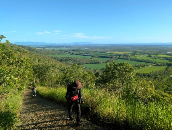
Start walking 09:10 am, twenty minutes along a rough 4WD track to enter the creek. Then it is a rock hopping jaunt along flattish terrain for 1.25 hours, past nice pools and creek scenery, this is easy. Water flow was very good, this creek flows all year. Find a nice smoko stop at a pool, swim time. About 11:00 am get moving, further upstream, more rock hopping, and start boulder clambering. We start looking for a lunch spot but Nick pushes us on saying “better spot ahead”. About 12:45 pm we find a good spot for swim and lunch.
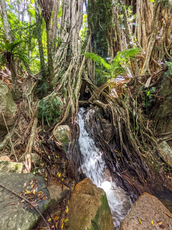
13:45 pm time to get moving, Mike turns around on his one dayer. Around 2-4 pm it was very hot and humid. And the terrain became more difficult. Now we get to small gorges where we needed to go over and around, bashing our way through downed trees and strangly vegetation, and some exposed friable surface – tough work. Four times we did this, and with the humidity it sapped energy levels. Frequents short stops occurred. But the pools and gorges were very scenic, towering hills with bare rockfaces, rocky outcrops and valley around. See lot of dragons on rocks, they disappear quickly upon seeing our leader.
At 3:50 pm we arrive at a nice pool with chute cascade and rock platform above. Phil recognises this from Alan’s photos and says it looks like the camp spot. Nick catches up, we eagerly enquire “is this it?’ and he says ”what are you stopped for, got long way to go yet!”. I glare at him, I have had enough for one day, buggered. But as I think I better get up and moving, Nick takes his pack off and heads for a tent site (the only tent site). This was the camp site, thankfully. Looking around, we are scratching our heads “where do we sleep?”. Scrambling around the creek bank, people were scrounging spots to put a tent or fly up, which was successful – not ideal, but good enough. Luckily only six of us though.
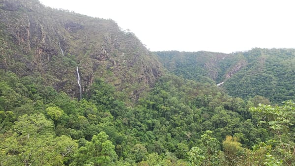
At 5 pm, four of us head for the waterfall which is supposed to be 15-20 minutes away. Without packs on, we felt good and scrambled our way up the creek. But that good feeling lasted for ten minutes and we were feeling buggered again. At 5:15 pm, we were having doubts with time and lateness of the day. Then we could see the waterfall in the distance, cascading down a sheer rockface. But to get the base we estimated would still take another 30 minutes. We had come 1.2 km walk from camp site, so we sat and admired the view, (at altitude 339 meters) then returned (2.53 km total side trip). We were about 300 meters from the waterfall at this point. Waterfall drop is about 70 metres. Cliff and hills directly above towered up to 160 metres (Google Earth review).
Back at the camp site, a good swim, then refreshments. Amazingly, there was no alcoholic refreshments, what a group. What was going on ? Camp site is at 260 metres altitude (Castle Hill height). Some of the visible peaks nearby are 573 and 694 metres height (southern side), with some peaks further away being close to 900 meters. On northern side valley height is about 440 metres. Some steep terrain above the camp area.
A pleasant night on the rock platform above the pool for dinner and socialising. Noel cooks up a massive feast, his pot overflowed. All to reduce pack weight me thinks. Good company, great location. Bed time, Noel sleeps on the rock platform, better than in the scrub.
Sunday
Wake up to an overcast morning. Nobody is keen to do a morning trip to the waterfall, so we decide to start return journey at 8 am. Generally overcast with small patches of blue sky.
Going downstream was easier, and our packs a bit lighter. Get to the first gorge blockage, time for a pack swim, rather than the hard bush bash. A pleasant refreshing pack swim down this small gorge. Re-dress, wander down the creek, to another gorge. Time for another pack swim, this has an more difficult entry, sliding into the water, for a great swim down narrow steep sided gorge. Life is grand. At the end, keep portaging and swimming in the creek line for a short while. This is a much nicer way to traverse the creek (only feasible heading downstream though). The day had become clear and sunny. Another gorge blockage, two go left into the scrub above, Keith goes right above, and Noel and Phil boots off and down the creek, shallow and short. We are then on the rock slides, some pack swim this pool, some the easy walk alongside. A nice break at 11 am. Very scenic spot. Downstream, the going is easier now, we get to a nice area with chute slides and pools, so spend 1:15 hours here swimming, lunch and relaxing. Another scenic spot. Then it was 1:25 to the creek exit point, easy walking, but hot and humid, then twenty minute track walk to the cars arriving 15:15 pm..
At the cars, Fiona produced cold beer and soft drinks. Then Mike arrived with more colds beers. Welcome refreshments. Stop at Frosty Mango on the drive home, a good way to finish a great weekend bushwalk.
Thanks to Nick for guidance and mentoring.
Future reference:
The walk starts on private property, then traverses to national park.
Need dry conditions for this walk.
The walk upstream consists of the usual creek rock hopping, boulder clambering, gorge traversing, scrub bashing highlights – and most importantly, swimming holes.
Waterflow is good. This time of year is good to rock hop in middle of creek. Albeit very hot and humid. Mid year the creek level may be too high to permit easy rock hopping up the middle of creek.
Camp site - 11.8 km walking. Allow seven hours for walking (including breaks).
Going up stream four lots of bush bashing (after lunch), hard work. Downstream you can pack swim the gorges. 2 to 4 pack swims, refreshing, nice and safe.
Tent sites are a premium. Site can fit in six people comfortably, anymore will be tight.
Waterfall is about 1.5 km walking from camp site. 1.2km distance (2.53 km return) to see a view of falls.
Grid ref : Camp Site 938 722. Maps Cardwell and Mt Graham 1:50000.
Bring something to waterproof your pack for short pack swims. Water wading footwear for these sections is recommended.