Hell Hole Gorge, Button Rock, and Running Creek 2016
A classic adventure through Hell Hole Gorge, Button Rock, and Running Creek in Paluma/Hidden Valley area. This 2016 trip featured remote gorge walking, granite climbs, creek swims, overland navigation, camping, and big North Queensland views.
Payback is a bugger. Monday we drove past old mine workings, which made someone mad. Anyway, get to the creek, park the cars, and look at map. Rapids downstream. So off we go to find these rapids. He came willingly, which worried me. I said to Phil ‘he is being too compliant, wonder what payback will be?’ We wander down this remote creek bed, away from the mine site. Over flat rocks; 'he' remarks ‘these must be the rapids’. I say ‘no, must be more significant to be on map. Let’s try next corner, looks promising up there’. We continue on to the corner to find a good rapid formation. Lunch here. At 1 pm we get ready to move, I say ‘we could go downstream to next corner ....’ — - ‘NO – I let you have your damned rapids, my turn now, to the mine site we go - payback time !!’. I look at my watch, five hours of daylight left – this could be a long afternoon in the mine scrapes ........
Saturday 30 April 2016
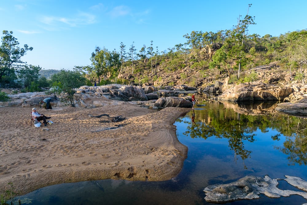
Seven bushwalkers assembled at Paluma at 8:15 am. Six athletic males plus a very fit Rosemary. 8:35 am depart Paluma in 4 vehicles, three Toyotas led by Mighty Triton ! Arrived Hell Hole Gorge car park 10:30 am. This year I wanted to camp bit further downstream nearer the top falls, which is what we did. A very nice sand bank with a good pool, and only a few minutes from the top waterfall and the gorge. This proved to be a great camp site. We took our lunch down to the top of the gorge and the top fall pool for lunch and swim. Then back to camp to set up camp.
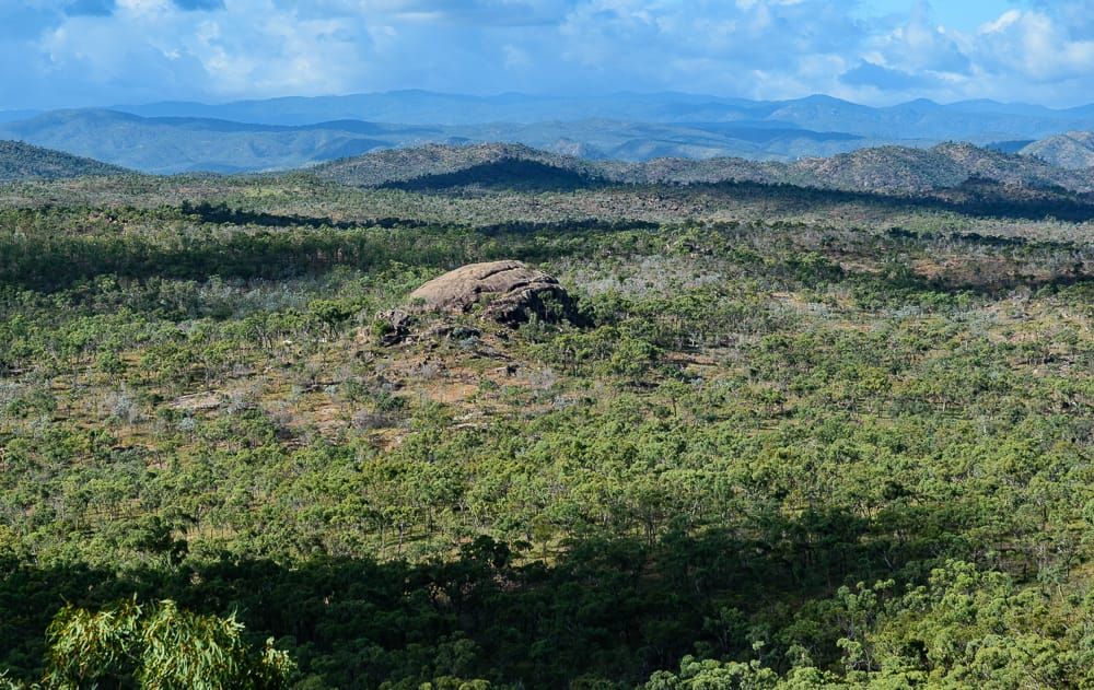
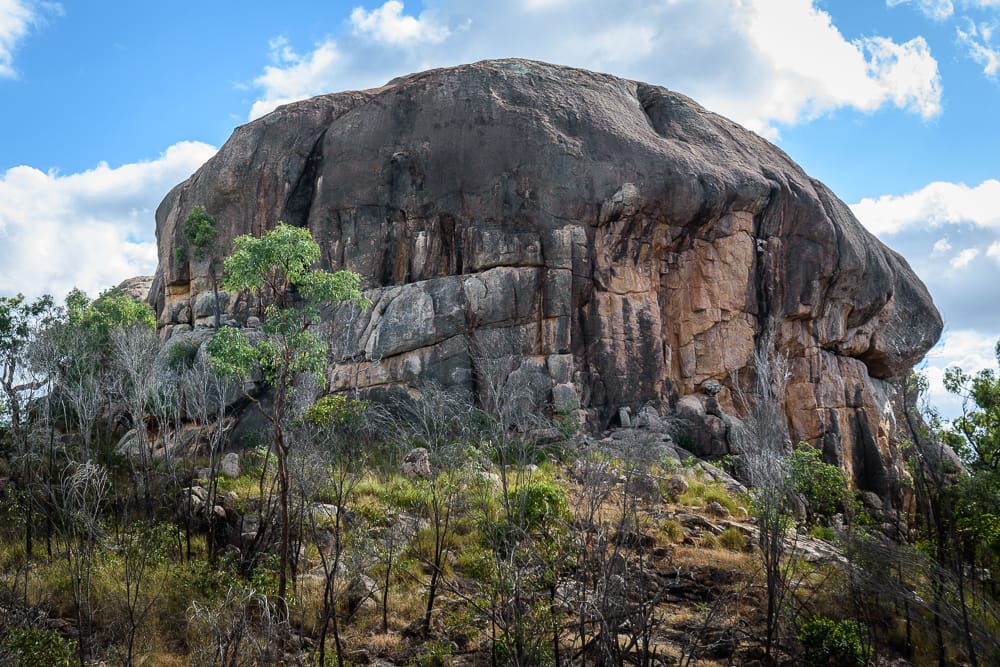
1 pm time to set up the car shuttle for tomorrows day walk. We all went to Button Rock, about 7 km drive south west. The vehicle track goes to the base of the granite outcrop, a large circular outcrop that dominates the landscape – and stands out on Google Earth too. A mini Ayers Rock. We decided we should all climb the rock today in case too weary tomorrow arvo after a full day hike. We climbed that for great views. Off the rock, at base of the rock Wilfred spots a large tree snake above in dead tree. About 1 km away are two distinct hills, one will be Mt Nokomis (697 mr, highest peak this area) so we aim for the highest looking and go there to claim a peak. But on top, we doubt this is the highest, and Mt Nokomis is actually the other nearby peak a short distance away. Discuss if we should try the real Mt Nokomis (a rocky boulder peak), but decide it is getting late in the day so trudge back to Button Rock. Leaving the Troopie at Button Rock, we all head back to our camp site for a swim and a good night under the Milky Way. No Iridium flares due this weekend, but we have the International Space Station (ISS), Hubble Telescope, and Tiangong 1 (Chinese space station) that should be visible. At about 18:36 we see the ISS coming over, a very bright object. Later we see the Hubble Telescope faintly as it passed through the Southern Cross pointers. A great night under the stars.
Sunday 1st May 2016
A new route. Plan today is to hike down the gorge further than we have done before, exit the gorge after a big bend and hike overland to Button Rock. We have never done this before. We picked a spot on the map in the gorge to aim for. Will be a long hike to get there.
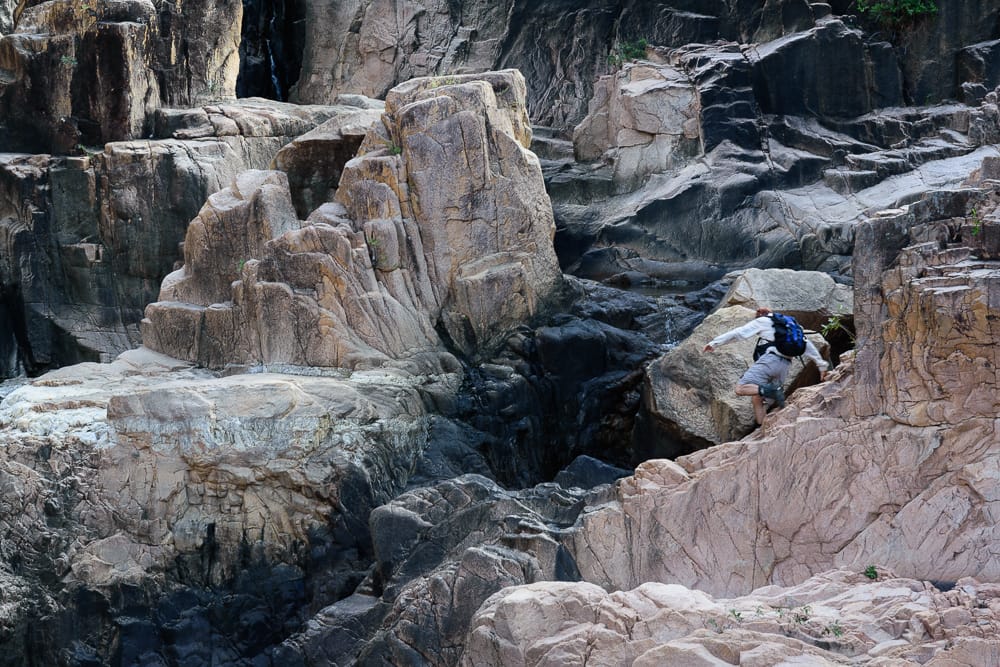
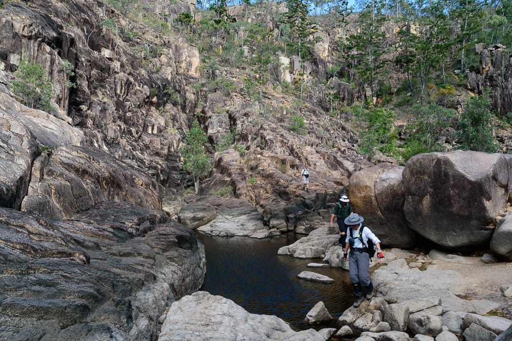
We depart at 8 am, the leader cajoling and pushing the early start. Big day ahead. Wilfred says ‘and I hope you are doing the gorge all the way from the top, not missing the top part like you have done before ?’. ‘Yes, start from the top!’. I tell the others starting this way is harder, but better landscape. Travis is leaving tonight, and not returning to camp this arvo so he carries his whole pack for the day - only 20kg or so ! ‘I need the training’ he states. We scramble and negotiate our way down the top of the gorge, Wilfred crossed to the left to the hairy gorgy bit, and we stay right on the hairy friable slope. We meet down below, some climbing a small pinnacle for photo opp. The creek water flow is not much more than a dribble, much lower than our previous visits. But the pools were cleaner and clearer than last week over at Return and Narke.
Now the hiking is easier, and we hike down the scenic gorge in morning light, fantastic. A large wedge tail eagle flies ahead of us, a grand sight. 10 am we stop at a great pool for smoko and a swim. It was here that some of us a brainwave – we could stay in the gorge and swim and have a nice day. Why did we have to hike overland to Wilfred’s Troopie – his car, he can go get himself uh ! He was silly enough to leave it there, he can go get it. Somebody was not impressed with that idea !
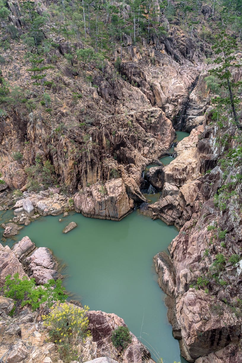
We move down through pink gorge, scramble over ledges and along steep rockfaces to pass where we got to last time, and march on. Luckily we had nice breeze today which made for good hiking conditions in the gorge. The plan is to get around the next big bend in the gorge. At noon we have started the big bend, ahead the gorge narrows, is steeper, and that bend is very long. At short way into the bend we stop for lunch and swim and decide this is as far as we should go this year. 7.7 km from start. To go all the way around the bend we do not have enough time, and terrain looks rough ahead. From our lunch point we still have a 5 km straight line overland trek to Button Rock, climbing out of the gorge and over terrain we do not know.
Travis studied the map and gave us a bearing of 240 degrees. Wilfred asked ‘did anybody waypoint Button Rock yesterday ?’. There was no reply. Someone said something about finding Wilfred’s ‘Landrover’ – oh dear, not a good thing to say ! 5 km straight line, I figure means 7 km walking (which proved right). Lunch is within a steep part of the gorge, opposite hill 487 towering above. We will exit the gorge around here after our relaxing lunch break. Some stare at the steep gorge rim above, asking ‘how do we get out of here ?’. But there is gully nearby so we aim for that to exit the gorge starting 1:10 pm.
It is a very hard steep climb, loose underfoot, we reach the top – well the false top, because ahead we see more climbing, we are only half way to the gorge rim, albeit less steep on a ridge ahead. This turns into a 2 km climb, as we were in an undulating land of deep gullies and small rocky peaks. We were often blocked by gullies so contoured our way around gullies and hilly peaks. The climb whilst gradual now just never stopped. We often stopped to survey the landscape in front to decide which route. I had three people with compasses behind me, I knew if I went strayed too far from 240 degrees I would know about it from them real quick. The pressure was on (I avoided using GPS or compass). After 2 km we seemed to reach the flatter high area, where the walking was easier. We had planned a diversion on the way to pinnacle 582 but we never gave that much more thought as we trekked overland, keen to just get to Button Rock. Especially seeing how this was not flat country up top, but a land of gullies and hills. Next time maybe. Another 1 km, on a hilly area, we spied the top of Button Rock 2 km away. But in between, more gullies to negotiate. But spirits where high with the rock in sight, and the pace picked up. Later we crossed the vehicle track, about 1 km to go, and it was a near sprint through burnt land, any faster we would have jogged. We reached the rock and the Landrover (oops Troopie) at 4 pm, that was a 7 km 3 hour overland hike. All told we did 14.8 km today. But Rosemary said the hike is not over until we climb Button Rock, so she leads two still active males up the rock. The rest of us just collapsed next the Troopie and relaxed. That was a great bushwalk, and good to do something bit different. And navigation overland using map reading and compass is good fun. We never had to use the GPS waypoint (two of us had waypointed it yesterday but did not admit that to Wilfred). And now we have ideas to extend further and do bit different next year as well.
A forty minute drive back to camp for a great swim. Another great night under the stars, we saw the ISS again, then the Chinese space station, then Hubble Telescope which almost ran into the top Southern Cross pointer. On the sandy bank around the campfire, the usual discussion and comparisons of what each is having for dinner. Cous cous seemed to be a common theme tonight – what dark murky culinary depths has the club descended into ? The absent ‘President of the Cous Cous Club’ must have been recruiting and will be pleased no doubt. We had a special treat tonight, as Rosemary made a damper which she portioned into smaller dampers, like scone size. These were quickly cooked up on the hot coals of the camp fire and we enjoyed a special treat. Even the sticky condiments. So if someone is willing to carry 1 kg of flour every trip, this might be a regular occurrence. In the pool we could see many small yabbies.
Monday 2nd May 2016
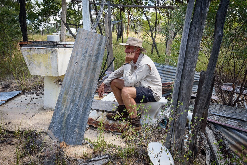
Awake to birds chirping. Three of rush off for morning photos of the top falls and gorge area. We slowly break camp, letting our tents dry. At 9:45 am we depart for the cars. Today’s plan is for a new area, at Running Creek, in between Hell Hole Creek and Running River. Not far from Hell Hole junction, at the swamp we turn on the track to the west, 5 km later arrive at Running Creek. No sign of the promised mining and old house area, so keep driving up the hill to reach a T junction. Review map, we are on the map edge. Decide to try the track to the left, as it goes to rapids lower down Running Creek. A short drive later and we pass old flattened buildings then mine scrapes but keep driving, which drove Wilfred mad. About 200 metres later we reach edge of creek and park cars. ‘Why did you drive past all that good stuff back there ?’ I am interrogated for.
Running Creek is a nice creek. Surprisingly with good pools albeit a bare dribble for its flow currently. In the rapid area there are circular rock pools with turtles. The map marks several rapids downstream of the old mine camp so there is potential for exploring down this creek also in future after good rain. Albeit, you can’t beat Hell Hole Gorge for spectacular landscape and good bushwalking.
We are dragged back to the mine area for payback time. We searched for the art gallery supposed to be at rock overhang - on opposite creek bank we spied a rock overhang so climbed up to inspect that, but no art here. It was too hot to search further afield, plus those damn mine scrapes had to be investigated yet. We explored the remains of the houses, even the outdoor ablutions (with septic system). Explored the mine pilings, wondering how they got all the river rocks piled up in these large mounds (we are told later they used a dredge). No sign of the promised old vehicles. 2 pm we start the drive back home, reaching Paluma at 15:30.
It was a very good weekend, great company, great camp site, and good to do something a bit different to our usual Hell Hole plan.
Next time we might try and go all the way down to the end of the gorge and camp lower down there somewhere, then next day trek overland to Button Rock via an old mine site marked on the map.
Regards
Keith
President


