Herbert River Falls June 2015
Herbert River Falls on the upper Herbert River delivered a memorable club trip with remote camping, gorge rim walks, riverbed hiking, fishing, and spectacular views near Blencoe Falls. A classic North Queensland bushwalking adventure.
‘Don’t need to bring food, we will live on the fish we catch’ was the briefing.
A three day trip was planned to visit Herbert River Falls on the upper Herbert River. This activity is on private property. This is the location where US Survivor –The Australian Outback : Season 2 was filmed in 2000 and screened 2001 (is still, to this day 2015, the highest-ranked season of the series). The club has visited here before, but for most of us on this trip it was new territory. So once again I was leading in virgin territory for me.
Meeting point was Cardwell roadhouse at 9 am. We assembled there, five vehicles, 13 participants.
Departed Cardwell at 9:30 am, north to Kennedy, turn off on to the Kirrama Range Road for the scenic steep windy unsealed road climbing the range. Stop at roadside waterfalls and lookout along the way. About 1 hr 15 minutes from Kennedy arrive Blencoe Creek, turn off onto side road for 5.6 km drive to the main lookouts for awesome views of magnificent Blencoe Falls and Herbert Gorge. We showed others where the helicopters dropped us off in the gorge last year (5 day fly in, hike 60 km out trip) and described the flight up the gorge and Blencoe Falls to land at junction of Blencoe Creek and Herbert River, they were amazed ‘what, they landed down there on that ?’ was the incredulous response. And ‘Are there saltwater crocs down there?’ – yes.
Back to the main road, then 15 km west to Goshen Station, pay the fees and collect gate key, obtain mud map and instructions. Might be a tight fit squeezing all our vehicles and tents into camp 5, so camp 4 might be a better option. If we do change camp sites, need to ring the station and advise them. Then 4.5 km west, turn off into cattle station property on dirt tracks and proceed through several gates for about 15 km. Arrive at camp 4, did not like that spot, and proceed to camp 5 which looked much nicer. 2:30 pm, set up camp.
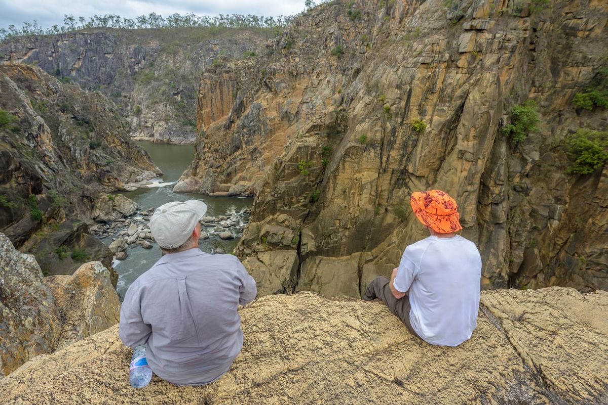
Directing that firewood needed to be collected, then watching some go bush to scrounge, Brent and I jumped in the Triton and went off to collect fire wood remotely - just happened to drive to the falls lookout and explored the falls area for over an hour. Spectacular landscape. Sheer sided canyon walls 150-200 metres high, thundering waterfalls. Getting late, better head back and find some wood – bet the others have collected bugger all. So we collected some branches, arrived back at camp to find a large collection of great firewood. Our piddly little twigs were met with derision by the others. Great night by the camp fire. But no fish, had back up food for dinner.
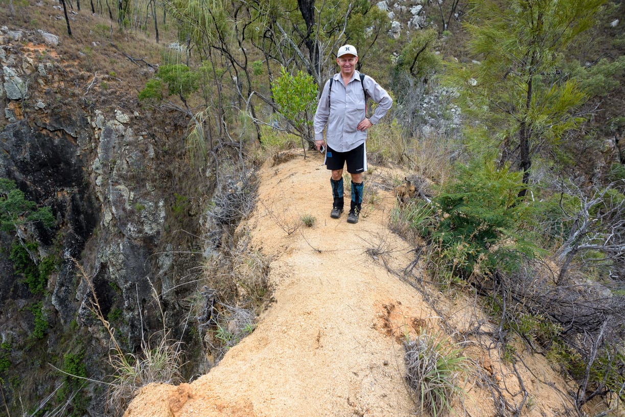
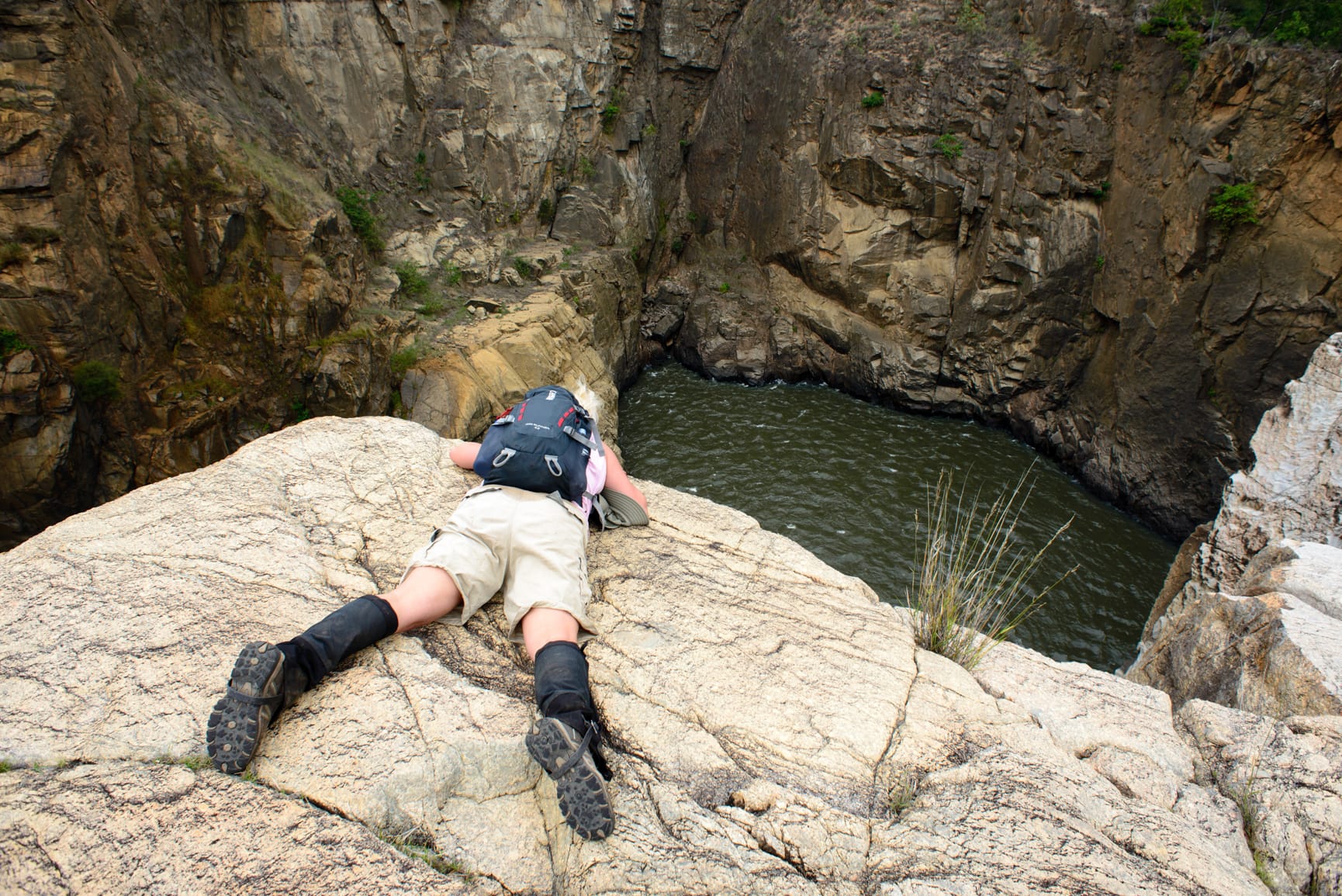
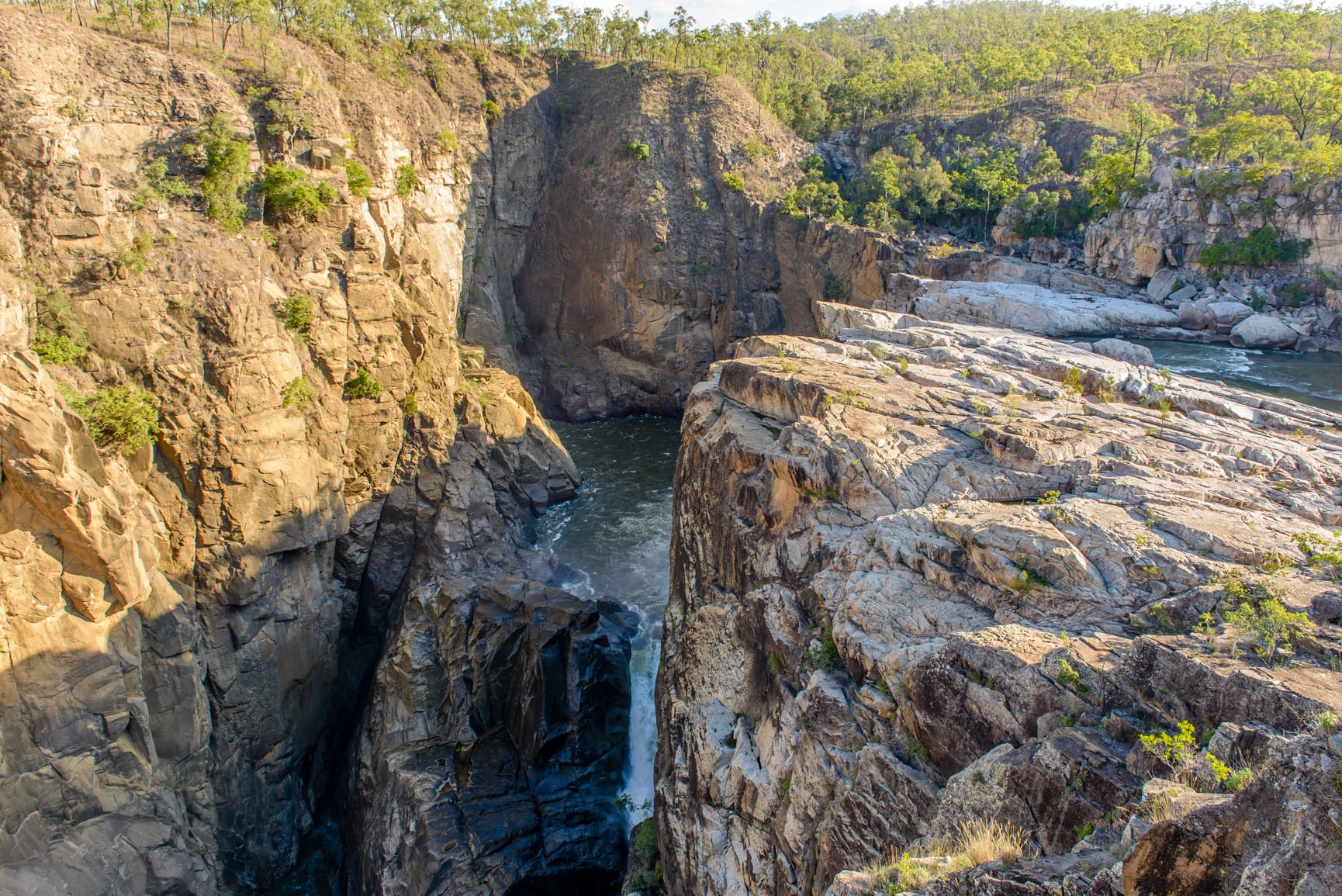
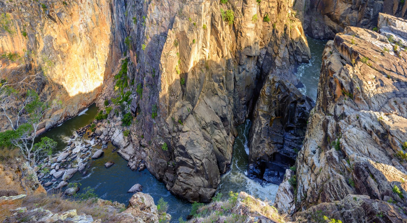
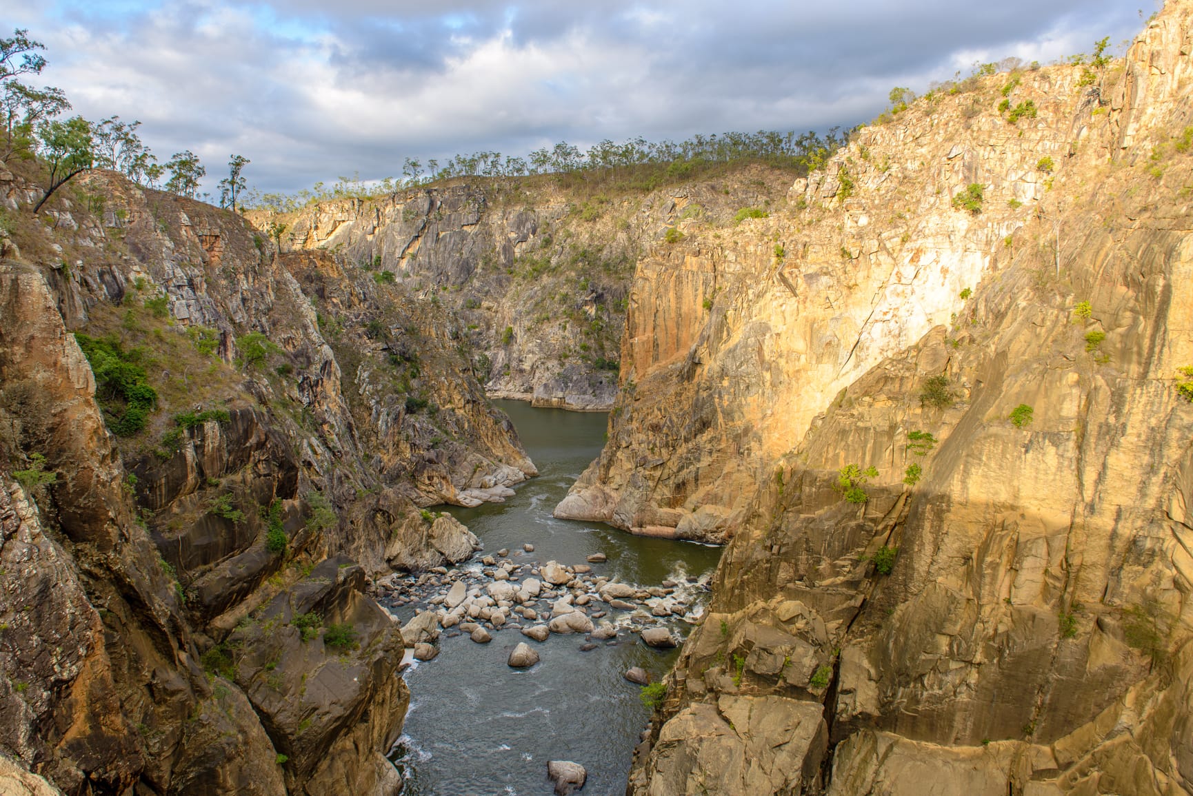
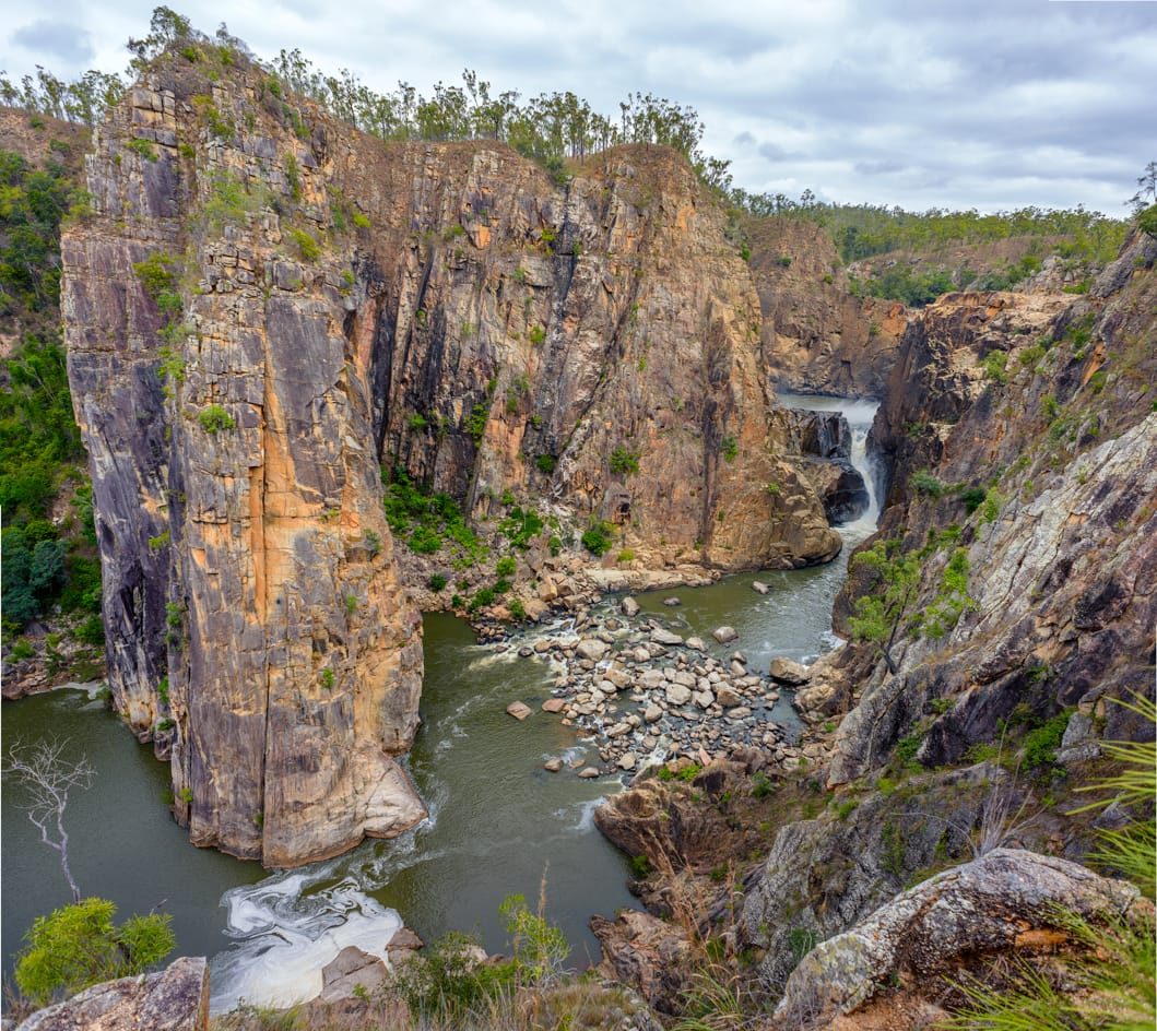
Sunday, 4:45am, wake to pitter patter on tent – damned rain. Jinxed this year. I blame Brett. 6:30 am still occasional drizzle. So much for trekking down the river in the river bed to the falls. Brent dashes off to the rapids for quick fish – comes back empty handed. 8:30 am assemble for the hike, 10 of us hiking. Standing there, one person slips and falls on the wet rocks (just standing) – so that confirms no rock walking, better go inland. As we start hiking I announce ‘virgin territory for me, see what we find’ which drew the usual sniggers in response. Proceed inland heading down to the falls and gorge. Easy scrub walking, mostly following animal pads. Abut 1 hr down, weather has cleared and rocks look dry, start of the first waterfall and gorge country, so down onto the rocks and great exploring of the top fall area. Back up to then inland a bit, three went down a steep rockface, the rest an easier route. Hiking on top of cliff escarpment to reach the falls car park and look out point at 10 am. Scramble down a short steep dirt track onto the rock platforms above the falls and main gorge. Superb views. 11 am decide to move on, back up top and stay on left side of the sheer sided gorge and see how far we can go in 1 hr, then have lunch. Aimed for a narrow ridge that jutted out into the gorge, thought that might be a view point – and it was. A narrowneck ridge with steep drop off either side, not for those with vertigo. Superb view back up the falls. Short distance on to reach another high point, it was midday, great views down the gorge. Had a quick look at the amphitheatre (side gully) from a rocky outcrop, planning future hiking, then returned to the falls for lunch. During lunch Brent caught a sooty grunter fish which was ‘donated’ to Wendy. Will be plenty more where that came from won’t there !
1 pm start the trek home, now dry so intend to stay in the river bed as much as possible when we re-enter it around the corner a bit.. We leave Brent to catch a feast of fish. Short time later, high on the escarpment, we look down to see Brent in the gorge striding along, to be blocked by sheer sided cliff. A large dead croc was floating upside down here. After entertaining us for some time with his attempts to traverse this blockage, Brent turned back. We re-entered the river to view the top fall again, then strolled upstream through river swamp, paper bark trees, then over rock bed and rapids, to reach camp at 3 pm. 11.8 km my GPS showed for the hike.
Bob and Tony had caught no fish, so dinner looked grim. I better show them how to do it, so off I go to fish. Caught ‘rockfish’ and ‘weedfish’. Hmhmhm. Ran into Brent who was fishing the rapids, he had nothing either.
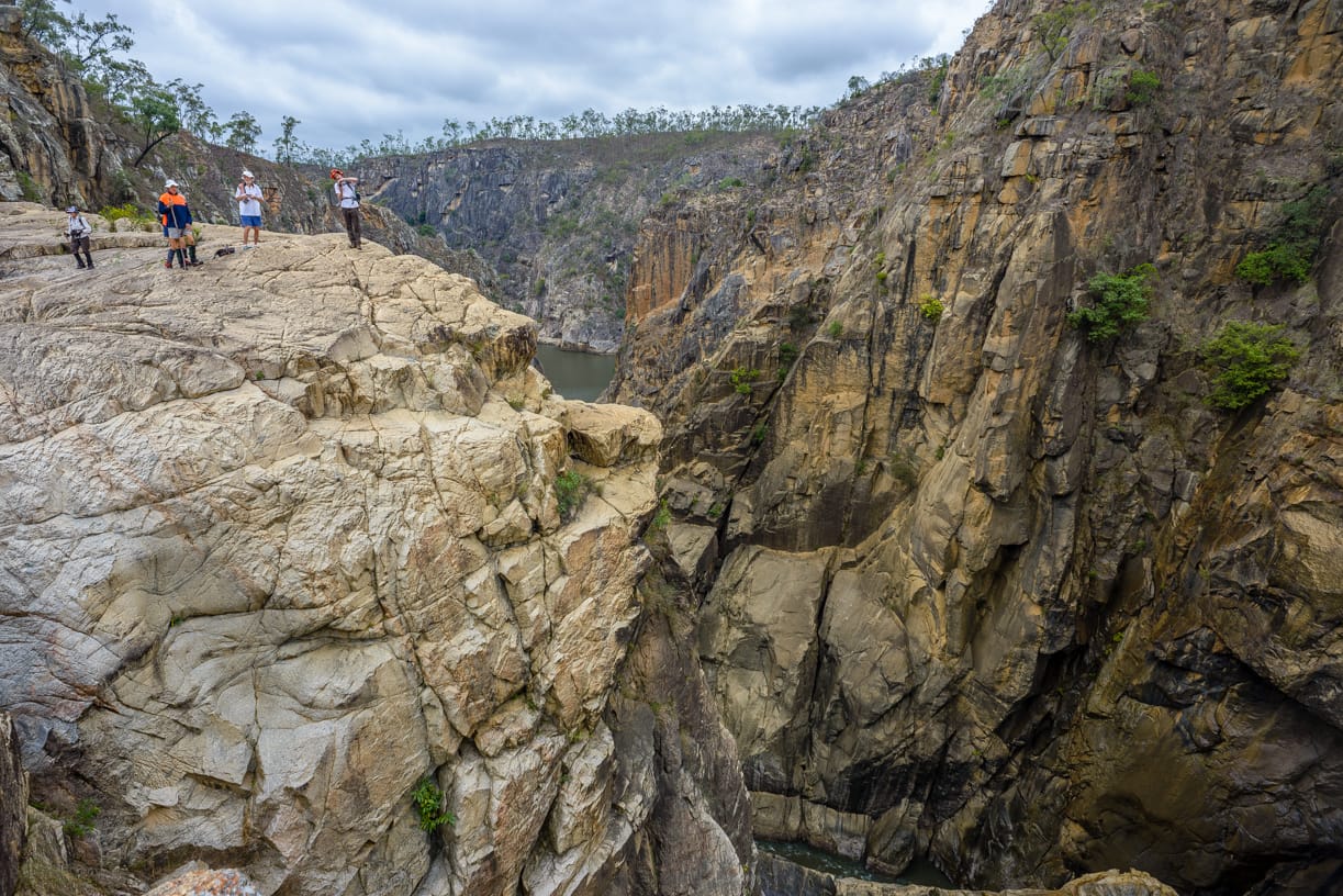
Dinner looked grim ! So did the rehydration liquids, as my bottle of port suffered lot of evaporation me thinks. Why does port evaporate so much ? Another good night around the camp fire. During the witty camp fire conversation we formed sub-committees for the club, especially safety. Their first risk assessment meeting was held earlier in the day at the top of the falls, as the photos demonstrate their risk assessment and appreciation process.
Monday, pack up, depart 10 am, to check out other camp sites before leaving. Drove on rough tracks to pass several sites to the Sandbar, a great camp location for a large group. Then drove to Daggerts camp site, then up to Kuchar campsite, another great site. Time to leave, back at the homestead at 12 pm to return the key, then the drive home. Quick stop at Cardwell for pie and drink – needed that pie due to lack of fish ! Arriving back in Townsville at 5 pm. Another great trip.
Notes:
Goshen Station campsites - Public holidays and school holidays are booked out for the year. If thinking of going during holiday periods, book well in advance (like year or two before). But best to choose non holiday periods as no crowds then.
16 camp sites of various sizes spread out along the river.
No facilities – bare camp sites only. Camp fires allowed, as is fishing, kayaking, and bushwalking. Can collect firewood around the camp sites.
Fee per vehicle is $50 access fee and $10 per night (as at 2015).
Vehicle tracks on the station are dry weather only tracks (black soil, creek gullies etc). High clearance vehicles are an advantage. Some tracks are eroded and steep.
Water should be treated or boiled, it is cattle country. We took our own drinking water up with us.
610 km return trip. Includes 164 km unsealed windy roads, and 40 km dirt rough tracks. Goshen Station is 82 km from Kennedy (Bruce Hwy turn off).
Allow 5 hrs driving time from Townsville to Goshen Station homestead. Further 30 minutes from the homestead to camp site 5.
We stayed at camp site 5. This is closet camp site to the falls which are about 2.5 km away.
Kuchar is another good site, sandbar, rapids, large pool. Probably okay for five cars and tents, but ground not real level.
‘Sandbar’ is a large site, solid ground for cars, lot of room for many tents on the sand areas. Very large sand bar. Great site.
Daggerts – average camp site and location.
Camp site 4 - squeeze five vehicles in, level camping, but river access steep bank and scenery not as good as camp 5.
Phone reception - Can get one bar on mobile phone at falls (Telstra only ?).
Future options:
Suggest minimum four day trip (three days is not enough especially considering the long drive). Five days would be very good.
4 to 5 day trip. Include a day of kayaking down the river, probably from Kuchar camp site to camp five. Requires car shuttle. Minor rapids along the way. Could start from Cashmere Crossing (15 km west of Goshen station on the Kirrama-Cashmere Road, but that might be a two day kayak trip to reach camp 5.
Two separate day walks along each side of the gorge rim downstream of the falls. Or a two day overnighter to stay on sand bar opposite Amphitheatre, allowing exploring of the gorge floor itself.
Access the gorge bottom at the Amphitheatre on northern bank, about 30 minutes downstream from main falls. Need raft to cross river to get to large sand bar to camp.
Can also access via Princess Station on southern bank, National Park camp site.
Regards
Keith
President


