Misc - Snakes, Conway, and Herbert info
Explore an ~mid-1970s bushwalking archive featuring a survival guide for identifying dangerous Australian snakes, including the Death Adder, Taipan, and Common Brown. It also includes a firsthand account of trekking the rugged Conway wilderness and Herbert River gorge.
A Quick Guide to Snake Identification
This is rather a difficult subject to write about with any great hope of success. It is a typical case of one colour picture being worth a thousand words. Better still is a visit to a zoo where the snake can be seen alive.
The advantage of positive identification should be obvious. It ensures that the correct anti-venene is used, and it may also provide some indication of the degree of urgency required in the treatment. A bite from an ordinary brown snake is nowhere near as serious as that from a taipan, tiger snake, or death adder. If there is any doubt about the type of snake, proceed on the assumption that it is venomous.
Death Adder
Can be found anytime but is more likely to be moving about at night. In the opinion of the writer, it is the most dangerous snake in Australia. It is usually not noticed until it bites and injects comparatively large quantities of powerful venom through well-developed fangs. It is the only snake which will not get out of your way, but it is not aggressive, just lazy.
- Habitat: Found nearly all over Australia, generally around loose leaves or sand.
- Shape: Short stumpy body, short thin tail, and a wide, flat, triangular head. Average length is 2'2" to 2'6".
- Colour: Generally dirty grey, but may be dusty reddish in colour with wavy dark bands.
- Venom: Mainly neurotoxic.
Taipan
This snake is not aggressive except when frightened. Then its size, speed of attack, and potency of the venom combine to present a dangerous animal indeed. If a taipan is examined, it will be seen that the most prominent scale on the head is shaped like a heraldic shield. This is an infallible means of identification, but if you are close enough to a live snake to see, YOU ARE TOO CLOSE. In torchlight at night, the eyes glow ruby-red. If you even suspect the snake is a taipan, LEAVE IT ALONE.
- Habitat: Mainly Queensland and Northern Australia. Gympie, in Queensland, appears to be the furthest south in its range.
- Shape: Rather slim body for its size with a thin neck and a long, tapering head which at first glance appears too large for the neck. Average size is from 4'6" to 6'0", although there is a specimen of 11'0" recorded.
- Colour: Dark brown with dirty yellow bellies, but older snakes have been noticed to be almost black.
- Venom: Potent and mainly neurotoxic.
Common Brown
This is the most pugnacious of all Australia's snakes but is still more inclined to retreat than attack. It is quite fast and bites repeatedly. It has the habit of coiling round its victim after biting and may be difficult to dislodge. The important difference between the brown snake and the taipan is the thick neck and small squarish head.
Cont....
Conway Conquered - Or Is It?
The third and latest trek to the Conway wilderness did indeed produce a long-looked-for result: the penetration of the unknown north end of the wilderness. We have now been from the sea in Repulse Bay to the sea in Pioneer Bay, a distance of some 20 miles, but for a 1 mile stretch at the Repulse Bay end where the salt and fresh waters meet.
It was an odd weekend that found no one prepared to go, so by prior arrangement, I left Friday night to meet Lee, Pat Magee, and Russell Williams (Mackay club) at the little property at Brandy Creek. At dawn the following day, we crossed into the Repulse watershed via the forestry road. Roughly 5 miles in, right at the pine plot, we were surprised to see timber felling. Local merchants had just dropped a Red Cedar that had to be cut into four to truck it out. The base of the tree was probably 12 feet in circumference. So much for one of the last coastal rainforests in Central Queensland!
The creek we were to follow was called Impulse Creek according to the timber workers. The map showed that it wound around a north-south ridge into gorge country. At eleven o'clock, we left behind the rattle of the dozer and followed Impulse. The creek, like the Repulse country towards the sea, was flat with rainforest along the banks. Pat could identify a great number of the trees and herbs that lined the sides.
At the foot of the ridge, the creek we wanted turned sharp right, reminding me a bit of Yaminie. There was some reduction in waterflow, but we were indeed in gorge country and remained so for the next day. Pat had not been walking for eighteen months and found the going laborious. Night found us well into the mountains and bedding down on a not-too-comfortable island in the middle of the creek.
After a leisurely breakfast next day, we pressed on, conscious that we had yet to cross the coastal rim, a range that is over 1,000 feet. From the branch of Impulse, the creek had been rising, and a fairly significant waterfall was passed. This involved roping off packs.
By 10:00 hours, the gorge had run into steep granite country, and myself into confusion. A creek that was on the map was not in reality - or I was hopelessly bushed. (In retrospect, the map is probably incorrect.) As it transpired, we could look back onto a granite wall from the rim of the gorge, and for a creek to run out of that, it had to be insignificant or run underground.
When the black granite became too large, we did a compass march up a convenient ridge thick with Acacia and Blackboy, so thick in fact that one had to force a path through and up. Rather unpleasant. Rainforest came again, this time with a deal of tangle and Water Vine, brought low by a number of large trees that had come down in the cyclone that wrecked so much of that forest a few years ago.
Just on noon, I suggested that a couple of kilometres would bring us to the mountain rim. It was then that we noticed that familiar skyline through the trees. We walked out on the rim about 200 yards from where we had hoped to come out. The walk down the escarpment was cool and interesting. Trees were much larger than those on the Repulse side, but all the creeks and gullies were dry. Such a contrast from the bubbling streams of Repulse, and only an hour's walk apart. The country at the top of the rim is
.... cont.
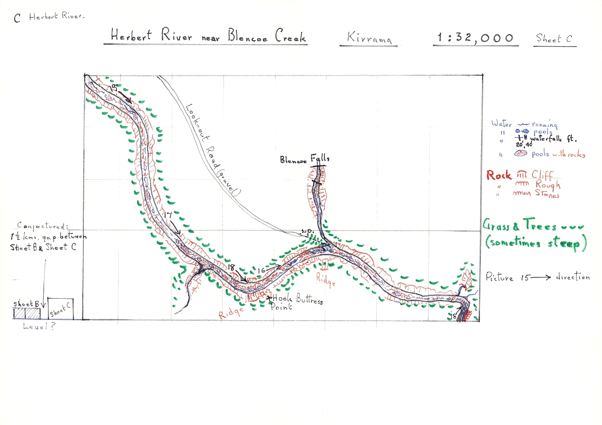
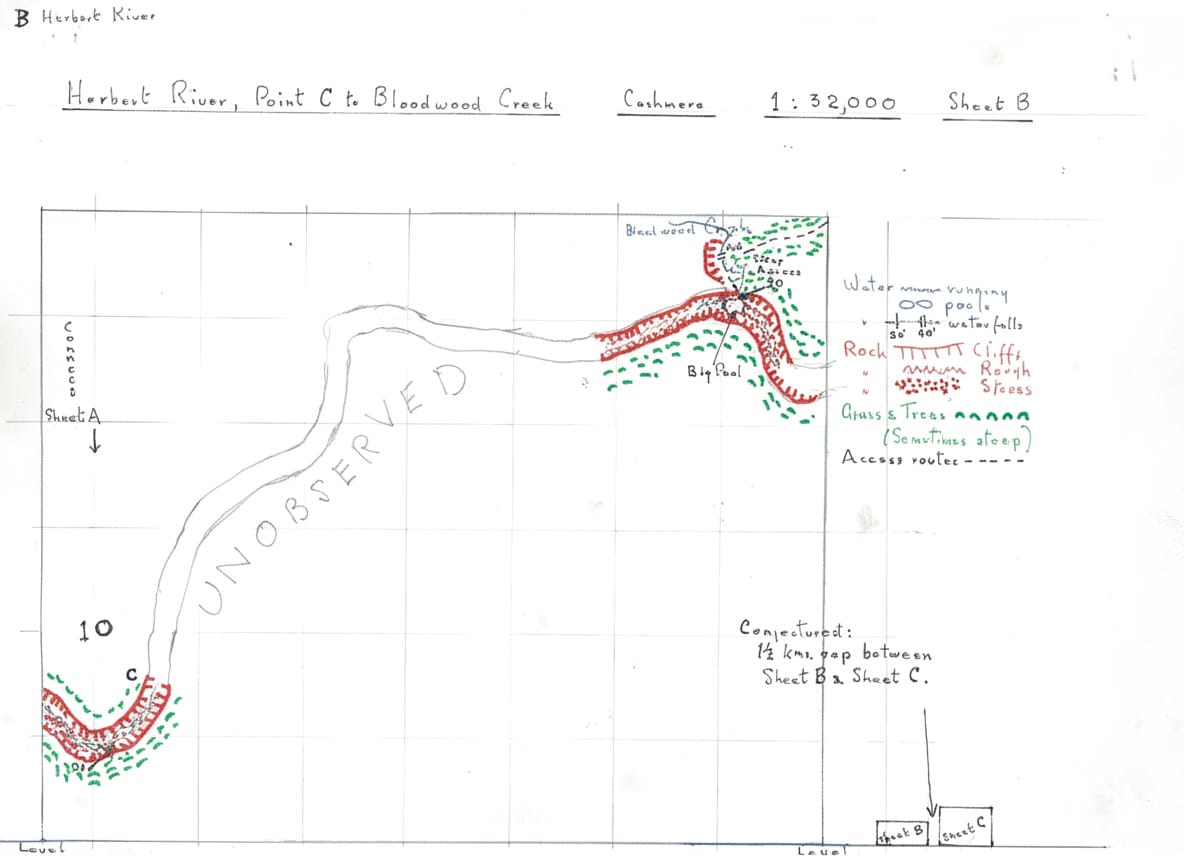
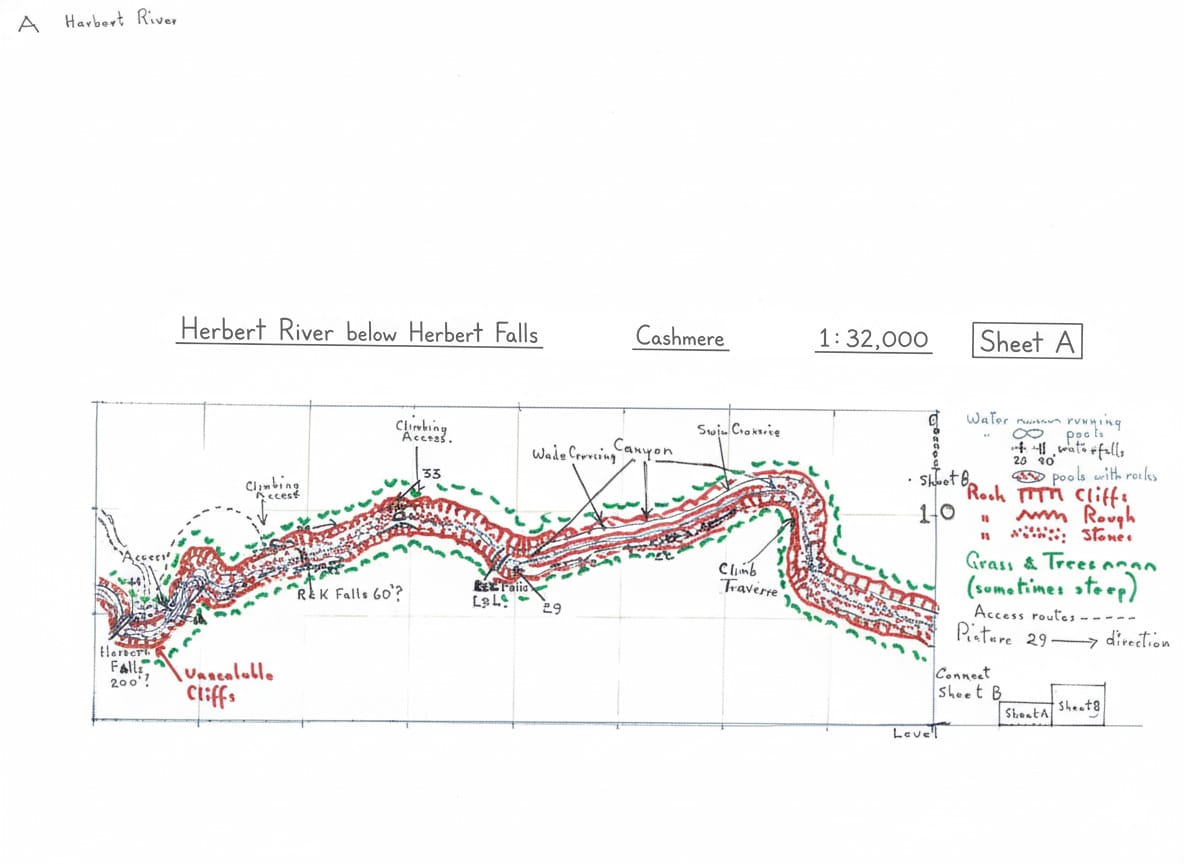
Hand drawn Maps
Locations Mentioned: Herbert River, Blencoe Creek , Kirrama , Cashmere , and Bloodwood Creek. Blencoe Falls , Herbert River Falls , hook buttress points , rock cliffs, unscalable cliffs , and pools with rocks.