Mount Bowen
Mt Bowen (1,121 m) on Hinchinbrook Island: a tough four-day adventure of rock-hopping, steep climbs, and a “shortcut” gone wrong. Stunning summit views, camp under the stars, creek scrambles, wildlife encounters, and classic mishaps made this a true bucket-list bushwalking challenge.
Mt Bowen, 1,121 metres, is the highest peak on Hinchinbrook Island, and is a bucket list item for many bushwalkers. It is an imposing looking mountain rising up sharply from the beaches, craggy ridgelines and rocky outcrops on the sides. Many try it, but not all succeed. A small group led by Graeme & Luen takes on the challenge.
Friday 8th September 2017
5:30 Graeme gets a phone call – ‘boat is ready to depart (Cardwell), where are you ?’. ‘Townsville’ is Graeme’s reply ‘thought boat time was 8:30’. Cranky boat skipper. Oops.
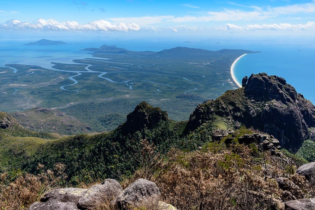
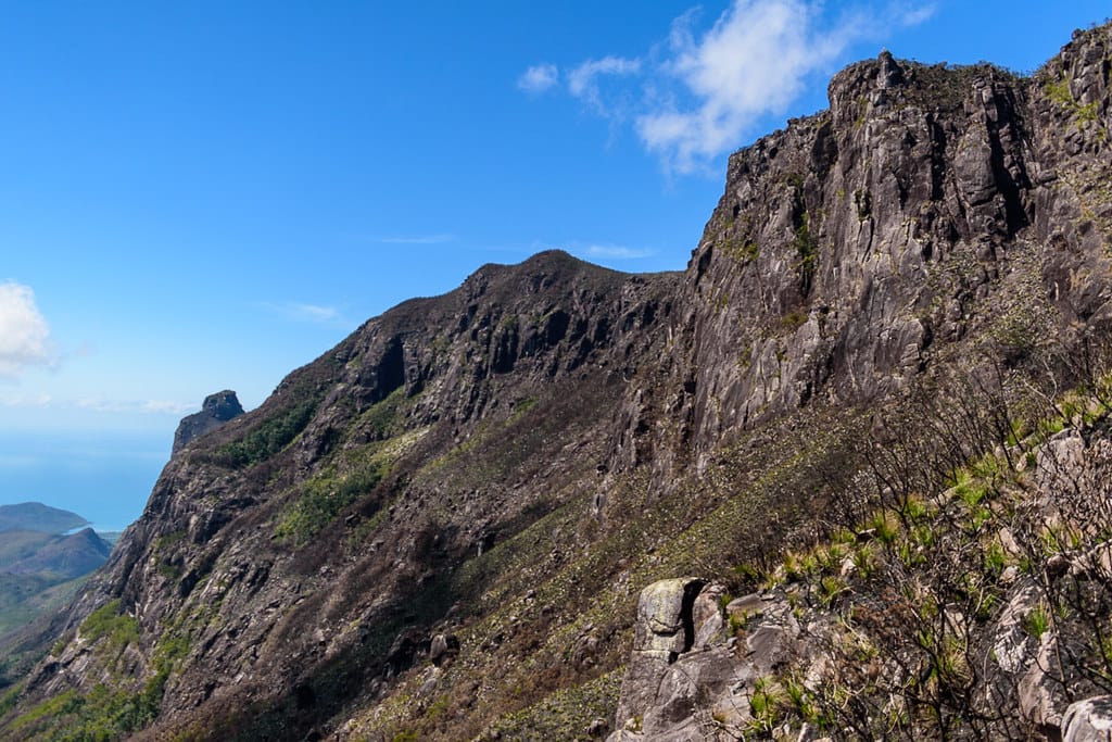
8:30 catch the boat from Cardwell to Hinchinbrook Island. Up the mangrove creek in Missionary Bay the imposing monsters of Mt Bowen, The Thumb and Pineapple Ridge dominate the awesome landscape. 9:30 arrive on the island, commence the 6.8 km walk to Little Ramsay Bay along the Thorsborne Trail, 1 hr 45 minute walk. Short lunch break at Little Ramsay. Looking up at our route, Warawilla Creek to the saddle, that looks very steep and jungle near the saddle, daunting. The Thumb and Mt Bowen (1,121 metres) soar above, monsters teasing us.
We start the walk up Warawilla Creek at 11:52, a long hot rock hop with heavy (four day) packs. We have no firm plan, see how far we get today. Finding a camp spot with water for six persons might be a challenge. Along the way we sight potential rocky camp spots, but decide to push in as far as we can today to reduce the adventure length tomorrow .After 3.9 km of rockhopping, at 3:17 pm, we find a suitable place to camp in rocks and boulders. Creek bank is thick gnarly vegetation, no hope of camping in there. 347 mr altitude. Base camp for two nights. The heavy packs made us work harder climbing up the creek. Earlier downstream, I outsmarted myself, thinking only one night camping in the creek, I offloaded some of my gear to reduce pack weight (food, cooking gear, etc), attaching to a tree in the creek. Now, later up the creek ‘Oh, two nights camp in creek now’ - damn (not enough food or gear now). Reasonable creek flow here. A few small pools below camp. Three had hammocks, the other three found ‘flattish’ rocks to make bed on, one fitted a tent, other two slept under the stars. Iron Man Chef made damper, very nice. At night a blood orange moon arose, awesome sight. Club rules, the 8 pm curfew (no sneaking off to bed before 8) was in place. Later, laying on my rock bed in sleeping bag (hoping I would not slide off the side into crevasses either side in the night), watching shooting stars and satellites.
Saturday 9th September 2017
Dawn, a bright red sun. What does that mean ? 7 am and the sun has bite in it already. Cardwell forecast today is 31 degrees. Getting ready, refill water bottle, a mossy rock results in a good slip and fall onto shin – ouch – nice immediate bruised leg.
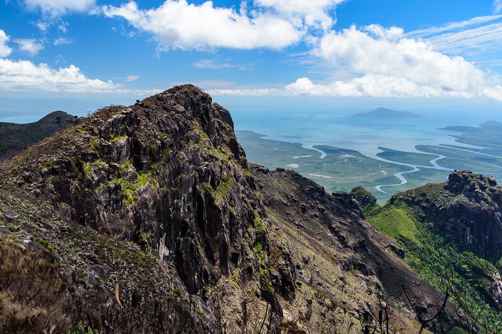
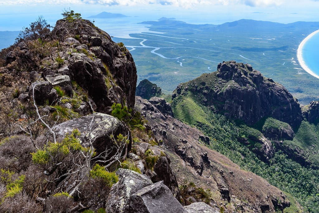
Early start 7:12, with day packs only, carrying five litres of water each, the first hour was very humid, sweat pouring out of us, we climbed steeply up the boulder creek. We naturally split into two groups, the three greyhounds, and us three wiser ones. Wiser meaning older and slower, and smarter (you would think). Rock cairns are at regular intervals which provide confidence that we are on route - it is common to take creek branches to the left and end up blocked by cliff face. At one spot we caught up to the serenading greyhounds. But most of the time the greyhounds were well ahead out of sight. The creek gets steeper and steeper. Near the top of the creek, the creek is less distinguished, find pink tape and a jungle track is on left side which leads to the saddle arriving 9:17. A 1.7 km two hour, 458 metre ascent hike from camp, to 808 metres altitude. Saddle clearing is very small, 10 sq mr. Great views of Pineapple Ridge, Mt Bowen, the Thumb, and beaches below. We made very good time to here.
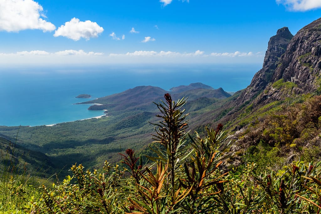
From the saddle onwards, the ridge and foreslopes of the mountain range were burnt off about eight weeks ago. The allowed easy walking up the ridge, through banksia and similar burnt native vegetation. Sometimes, bushwalkers are grateful for burnoffs. At a rock outcrop, we spy in the far distance a nudist colony on a higher rocky outcrop. Reach what we hope is the summit, but is a false summit. Ahead and above is the summit, twenty minute walk further on through light burnt scrub. We reach the summit (1,121 metres) at 11:18 am, a 353 metre ascent 1.6 km walk from the saddle, and 801 metres ascent 3.3 km hike from camp. We read old stories and notes in the log book container at summit cairn. The club evens gets a mention from back in the 70s or 80s. We write our names in the log notes. Views all around the island over rocky pinnacles, mangrove channels, beaches, the inland channel, and mainland, to the Palm Island group, and way up north. We stare at an imposing The Thumb not far away, daunting, a challenge for the keen on another day.
To be on the mountain ridgeline for sunset and dawn would be amazing.
After lunch, the descent starts at 12:24 pm. All downhill. Easy. Promise. Fair dinkum. Us three wiser bushwalkers, decide to try a shortcut off the mountain to avoid the rock hop down the creek and also beat the three greyhounds back to camp. WK reckons we can get down in two hours, nice burnt foreslopes, open cross country, cut half the distance out (from summit to camp straight line is only 1.3 km), albeit steep and friable surface, but all good. 'Easy shortcut'.
Now there are wisdom sayings in the club - 'what could possibly go wrong' and 'when the fun stops the adventure begins'. So after an easy 862 metre walk along the open ridge, at 12:58 pm, at 1066 metres elevation, us wise ones drop off the ridge line onto the easy looking shortcut. The greyhounds, well ahead, stick with the known and used ridge and creek boulder-hop route. If they only had the wisdom us wise ones have !
Down the mountain steep foreslopes, open burnt county, bit friable, but good going, easy. About one hundred and fifty metres descent run into a thicket gully, bash our way through, back in burnt open slope. Then run into more viney thicket, more tangled and bashing. Decide to keep pushing right as that is where the burnt open bit should be. Then at 2 pm, one hour walking, 700 metres elevation, after 700 metres walking, arrive at an open creek line, bit mushy underfoot, and this was start of water flow feeding this side creek. A terraced rock face creek blocked us going down. Looked pretty, but did not care about pretty right now. Going down this creek is not an option due to sheer wet cliff faces and drop offs in the creek, and thick vegetation on the sides.
Decide to keep going right, into greenery (it will not last long will it, be back in burnt country soon right ?). We were making slow progress bashing our way through thick vegetation for 380 metres, took 55 minutes for this short segment. Where is that damned burnt bit ? A clear area ahead, we are jubilant - to find we have arrived at top of a cliff face. We are blocked. Damn. Now at 633 metres elevation. Try left to get into the creek, bashing through gnarly tangled crap, to be blocked by cliff face again. Backtrack a bit, with scrubby saplings snagging and tearing at us, steep climb and loose underfoot back up making progress slow. Going back up sucked. Whoever said Hinchinbrook Island was beautiful, has not been in this part. Discuss options, there was talk of back up to the ridge line, but decided 'let's keep right again – find that burnt line down the mountain' (how did we lose it?). Going right is closer to camp. Bashing our way through tangled scrub, every time we tried to go down we found blockages. Tiring and getting frustrated, check GPSr, we are 720 metres from camp, at 3:25 pm. That lifted spirits – not far to go. Albeit, a 250 metre descent to camp site over the 720 metres – hhhmmm that might be interesting. Warawilla Creek was only 100 metres away too, but way below in thick green stuff. Along top of the scrubby cliff line to the right we head, after more scrub bashing, zig zagging, backtracking, probing, cursing, legs and hands getting shredded, we are 705 metres from camp and 80 metres from Warawilla. Thirty minutes to get 15 metres closer ? Next cliff at 560 metres elevation, a 387 metre bash from the last cliff, took 1 hr ten minutes, now 4:12 pm. The wisest and most elder, says 'next time I get an idea like this, please hit me on the head with a lump of timber!'. The fun must have stopped. Albeit, Joy was giggling a lot, having a ball. Keep pushing right along top of cliff line which we see extends for long way. Short time later after more bush bashing along cliff line, check GPSr again, we are now 700 metres from camp. Oh! Well, at least five metres closer to camp now. Finally find a cutting in the cliff we can scramble down, then we are able to zig zag down a granite slope, back into scrub. We were thankful to be in the mongrel rainforest scrub, even though that meant bashing our way through, tangled and caught up, tripping, at least we could make ‘some’ progress now. Sun is getting low and will drop behind the mountain ridgeline soon. Start having thoughts on what do we do when darkness arrives ? More bush bashing, then to top it off wait-a-while and vine jungle. Gotta love nature. 141 metres bush bash from the last cliff line finally we re-enter Warawilla Creek at 16:42 pm. That was a 1.7 km wandering zig zag 580 metre descent 3.5 hour ‘shortcut’ to Warawilla. Straight line would have been 950 metres – it really is a shortcut if in a straight line ! But, we were not closer to the camp as we short cut planned (kinda planned a direct line, but that was not the result by entering Warawilla here upstream).
Check distance, 685 metres to camp (so in one hour we had only come 35 metres closer to camp !!). But to placate our wisest elder I had to say 500 metres to camp - he threatened to destroy the GPSr if it said 700 metres again. Rockhopping down the creek in dying light, seemed forever (was really 800 metres creek walk with zig zagging), to stagger (no, we marched proudly) into camp at 5:30 pm, tired, dirty, scarred, cuts and scratches. The three unwise greyhounds at camp are relaxed, clean and calm. They served us fresh pikelets as a reward upon arrival. That shortcut, we travelled an extra 72 metres compared to the long route, and took an extra two hours. The greyhounds beat us by 2.5 hours (at least). It was a good adventure - we highly recommend Wilfred's Guided Easy Shortcut Tours. As we cleaned up, the greyhounds, with too much energy to spare, performed yoga on a boulder. Iron Man Chef starts preparing camp made strawberry yoghurt for breakfast tomorrow, needs overnight to cure. At night, a Melomys Cervinipes (?) native rat hangs around, and steals a tea bag.
Sunday 10th September 2017
Another nice sunrise. Breakfast, the strawberry yoghurt had not set and was more like strawberry milk. Break camp, 7:45 start the rock hop down the creek to Little Ramsay Bay. On arrival, use sat phone to check boat timing for departure tomorrow - 11:30 is depart time. We decide to overnight at Little Ramsay. Looking back at the mountain, we can see the burnt foreslopes almost all the way down with green strips intervening – oh, if we had just kept going right when higher…...
Chilled out for the afternoon. Some do yoga on the beach. A goanna investigates the camp site. We sat on the beach and compared our beaten bodies – the unwise greyhounds were unbeaten, scratch free and full of energy - us wiser older ones had scratched and cut legs, arms, face and hands, and no energy –– something to be said about being older and wiser ! Albeit, their clothes were tattered, and someone’s shoes need intense re-stitching. Being creative and energetic, they even made hats and grass skirts out of palm leaves. Later we sat on the beach for the evening and early night under the Milky Way, and a celebratory nip of port each.
Monday 11th September 2017
A nice dawn on a beautiful tropical island beach. Talk of lunch – ‘what are you having in Cardwell?’ Burgers, fish and chips, ice creams, icy cold drinks, great coffee, all good motivation to get going. We donate gas cylinders to a group doing the Thorsborne Trail who were having problems with their Jetboil stove. At 8:10 we depart on the 6.8 km morning hike back to Ramsay Bay for the boat. The greyhounds race off to climb Nina Peak on the way. Just before reaching Ramsay Bay beach, Wilfred spots what looks like a side track leading into scrub – ‘a short cut?’ – Joy and I stare – ‘No, no shortcut today !!’.Reach the boat, after a 6.8 km 210 mr ascent 202 mr descent nice easy track walk. Boat has icy cold soft drinks which were well appreciated. Sitting in the boat, our four day old clothes are well and truly rank. Back in Cardwell at 1240. Change clothes and feel like new people. Fish and chips for lunch, icy cold drinks, coffee – luxury. Driving home, talk of Mt Diamantina, Mt Straloch, Waterfall Creek, and other future adventures. Frosty Mango for ice creams on the way home to top off a great trip and celebrate another challenge ticked off the bucket list.
And seriously, Wilfred does offer guided easy tours in the Paluma / Mt Spec / Hidden Valley area if you want to make a booking for a very good guided ‘on track’ tour to special areas. Just be careful of the words ‘easy shortcut’.
- Keith


