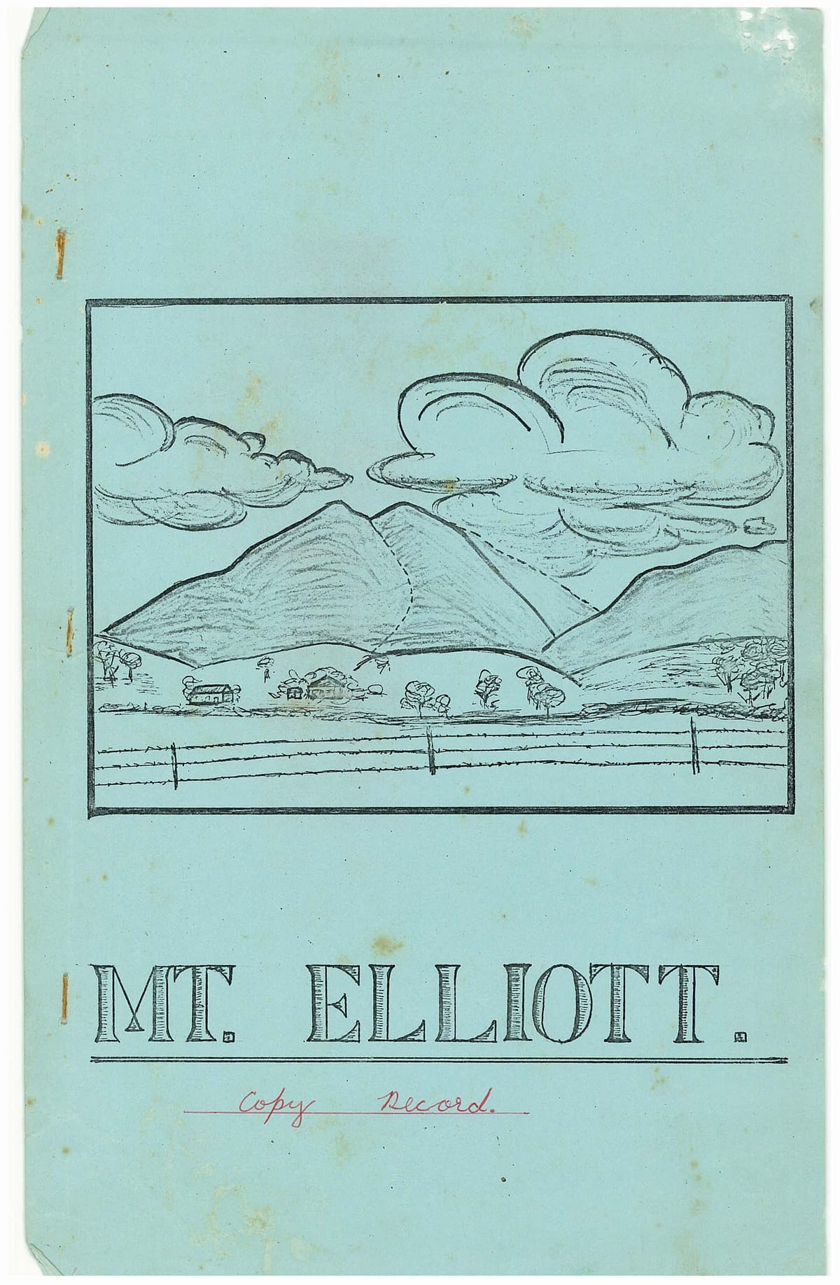
Mt. Elliott. - Copy Record
Discover historic bushwalking reports from Mt. Elliott National Park, located 14 miles from Townsville. Written between 1968 and 1971 , this guide offers trail notes, local history, and vivid accounts of hiking the rugged peaks of North Queensland.
- ELLIOTT NOTES -
Notes and articles contributed by members of the Townsville National Fitness Bushwalking Club, and edited by P. Biddle.
INTRODUCTION:
The Club first began to show an interest in this little known area in early 1966. Early walks consisted only of one day forays along the creek lines, or climbs onto the outer ridges. Enthusiasm to traverse the whole area became strong in 1967 and resulted in extensive walks being carried out, first by trip leaders, P. Reimann, L. Darvenisa, and later E. Kelly, P. Biddle, and others. Whilst some walking of the main range was undoubtably carried out during the last war, very few people have penetrated the summit peaks in recent times. The purpose of this folder is a short introduction to the area followed by maps and trip reports of some of the major walks into the region.
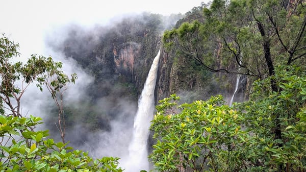
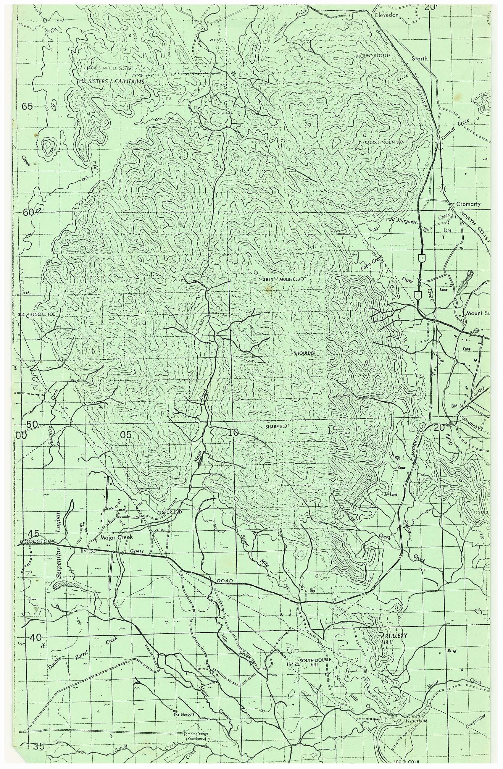
The Mt. Elliott Area, gazetted as a national park during 1940 is located about 14 miles south east of Townsville and some 25 miles north west of Ayr. It has a total area of about 60,000 acres. Two mountain groups are included, the main Mt. Elliott Mass, and the Saddle Mt. area, sometimes known as Little Elliott. The central mountain area resembles in shape a rough horseshoe and is a granite mass rising abruptly from the coastal plain to a general level of about 3,000 ft., from which ridges run to the higher parts, these being: Mt. Elliott Peak 4,000 ft., Bluff Elliott (Shoulder) 3,350 ft., Sharp Elliott 3,850 ft., and an unnamed 3,600 ft. peak on the Western Spur.
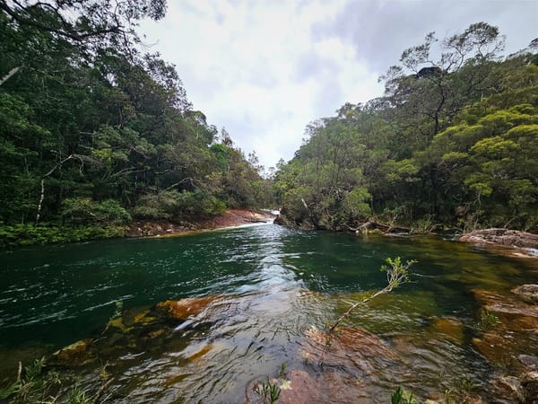
Vegetation along the creek lines contains, umbrella trees, picabeen palms, wild bananas, tree ferns, giant ferns, the northern Gympie stinger and the mulberry leaf stinger, Moreton Bay chestnuts, milky pine, hoop pine, red cedar flindersia, tea trees, casurinas, and silky oaks. Golden orchids grow along the creeks in profusion.
In the rain forest areas there are numerous orchids, black, golden, pencil etc, staghorns, elk horns, crowsfoot, and haresfoot ferns. Johnstone River maiden hair and tassel ferns occur in places.
On the dry ridges, bloodwood, tallow-wood, iron barks, kurrajongs, large and small zanias, banksias, Burdekin Plums, and yellow flowered wild kapok are common.
For the bird watchers there are numerous parrots, an assortment of finches, cat birds, whip birds, pidgeons, white and black cockatoos, yellow throated scrub wren, southern and northern kookaburras, and the megapod scrub turkeys. Wild pigs are common throughout the whole park and should be treated with extreme caution. They do not need to travel to water but derive enough moisture from eating the cunjevoy lillies and bulbs. Wild dingoes and brumbies are common on the lower slopes. Also there is a large assortment of snakes and intending walkers are well advised to wear shoes.
RECORD OF WALKS:
| PLACE | DATE | NO. OF WALKERS |
|---|---|---|
| Mt. Elliott Summit | 24/25-8-68 | 4 |
| St. Margarets Creek | 14-7-68 | 5 |
| Beehive Peak | 19-10-68 | 2 |
| Alligator Ck. Falls | 1-11-58 | 3 |
| Western Ridge | 26-12-68 | 1 |
| Sandy Ck. | 11-5-69 | 2 |
| Majors Ck. | 17-5-69 | 2 |
| Ant Hill Ck. Gorge | 1-6-69 | 4 |
| Mt. Elliott Summit | 31-5-69 | 3 |
| North West Ridge | 27-7-69 | 2 |
| Western Ridge | 5-9-69 | 2 |
| Sharp Elliott | 9-11-69 | 10 |
| Mt. Elliott Summit | 22/23-11-69 | 12 |
| Eastern Ridge | 28-12-69 | 3 |
| Western Flank | 28/29-3-70 | 3 |
| St. Margarets Ck. | 13/14-6-70 | 2 |
| Spur End | 5-7-70 | 9 |
| Walkers Ck. | 3/4-10-70 | 2 |
| Spur End | 31-10-70 | 1 |
| Spur End to Alligator Ck. | 7/8-11-70 | 6 |
| Double Ck. Chasm | 19-12-70 | 7 |
| Sharp Elliott to Mt. Elliott | 27/28-2-71 | 7 |
The following articles are records of trip reports dealing with some of the Clubs major walks into the area.
MT. ELLIOTT SUMMIT TRIP
24/25-8-68.
Leader: P. Reimann.
On Saturday morning four bushwalkers, P. Reimann, Val and Ray Berry, and myself left early for the climb to the summit. Access was from the Bruce Highway, then 3 miles to the right on the upper Alligator Ck. Rd., after which we arrived at the Nat Park picnic area; a beautiful spot where we left the cars. We then followed the four wheel drive tracks which run parallel with the N.E.A. power lines through the gorge. After an easy 2 miles or so we arrived at the syndicate hut. This is the ruins of a pine apple and fruit growing venture by some local wharf labourers many years ago. Crossing the locally named Sandy Ck. we then left the tracks to turn right and begin on the long curving ridge running up to our proposed camp site. The assualt on the first ridge proved quite steep and the party was glad to stop for morning tea at 10.30 a.m. After this we proceeded along the ridge following brumby pads, then scaled a huge rough knoll covered with long grass and submerged rocks. Once over this the vegetation increased to heavy forest and we made steady progress up a narrow ridge. This is the left-hand skyline ridge seen when looking at the peak from Townsville. A halt was made for lunch at 1 p.m. Following the ridge line we were soon level with Saddle Mtn. at 2,800 ft.. At 3 p.m. we came onto the massive outward facing shelf of the mountain, and entered into dry rain-forest. Here our progress became slow indeed as we each took turns in the lead to try and force a way. Here we learnt our first lessons in dodging the thicker areas where timber has fallen and let the sunlight in, thus allowing the undergrowth to grow. Campsite was reached at 4.30 p.m. this being a rock outcrop at the head of the ridge, altitude 3,600 ft. A great panorama is available here, especially to the east and north. Southwards could be seen the towns of Giru, Brandon, Ayr, and Home Hill, and intervening country. Also the seemingly limitless coastal plains including the river systems of the Haughton and Barratta's. We were very conscious of our small place in the universe as we sat spell bound and gazed out over those green razor backed ridges.
Rising early next morning we were treated to a fabulous sight as the whole of Saddle Mtn. and lower Elliott slopes had become cloud. covered and we were above this formation. Here on the roof of the morning at this time of the year only the tops of the mountains show. One got the feeling that here on the green pyramids of Elliott time is not much later than the morning after creation and that this area's formation had been a last hurrying job of throwing together a wilderness too ruggedly wild and wet and careless to be an Eden.
The party left for the summit approx half mile away to the right at 8 a.m. This entailed a trip down through a low saddle then an easy climb out up the ridge through genuine rain-forest. The summit was reached at 9.10 a.m. Due to the overhead canopy of trees there is no great view from the peak unless one is adept at scaling moss covered forest giants.
After only a short stop on the summit we wet off down the opposing ridge towards a creek which runs up the sides of the range. Losing height rapidly we pushed through wide areas of undergrowth and gained the headwaters of Cockatoo Gorge at 11.30 a.m. The remainder of the day was spent rock hopping down the gorge which proved most interesting. We rejoined the power line track at approx 5 p.m. A sow and suckers were disturbed after leaving the entrance to the gorge. The cars were reached at 5.30 p.m. This was our first official club trip to the summit. P. Reimann had previously made a great preliminary effort on 8-7-68 attaining the summit and back in one day using our descent route both ways.
P. Biddle.
SHARP ELLIOTT.
A TRIP TO THE EDGE OF THE UNKNOWN.
9-11-69.
Leader: P. Biddle.
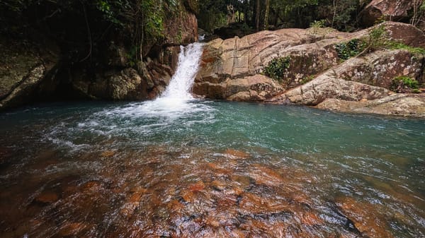
Lying almost due south of the central Mt. Elliott and about 8 miles away along the shoulder of the range, the peak of 3,850 ft. is an impressive land mark in the Giru Woodstock area. Little was known of the area and we had no knowledge of any previous climbs. In our attempt on the peak the party of ten began the climb of a ridge which forms the watershed between the twin branches of Double Ck. After obtaining permission we passed through a cane field, over a small hill, and an intervening gully of long grass. Then began our first climb up a stony ridge of about 800 ft. From here Cape Upstart could be seen in the clear morning air. Due to the fitness of the party being variable, I divided them into two groups with L. Darvenisa leading the rear group. The forward group pushed on and after bearing a little left crossed a short saddle which led to the main connecting ridge. Rising continuously this ridge runs in an almost straight line back to the summit. From a knoll at 1,300 ft. we could look onto the cliff faces below and to our left. This is the gorge of Double Ck., just below the chasm, a remarkable cleft in the granite, about 100 yds. long, up to 60 ft. deep, and only 2 to 3 ft. in width. At about 2,100 ft., the vegetation began to change and oak and palm trees became prominent.
Panoramic views to the south and south west were a great reward for the camera enthusiasts. After a short stop for morning tea at 2,600 ft. the party began to climb in earnest. A young pig was startled from out of the undergrowth. Soon the group were plodding through a great area of thick bracken, fern, and short prickly palm trees. Loya vines made there presence felt between this point and the summit. A break in the undergrowth and rain forest occurred at 3,100 ft. where extensive views were open to the west. A vast area of rain forest was visible looking out across the opposing valley of Double Ck. Many small wild flowers were growing in this clearing.
The ridge took a decisive turn to the right and progress became slower as the climbers entered into genuine rain forest. Travel was on a feet deep carpet of rotted wood vegetation, under a canopy of jungle which almost shut out the sky. Extensive areas of the jungle floor had been turned over by pigs. Many old scrub turkeys nests were seen but more of recent origin. This much maligned bird has now retreated back into the deepest recesses of the rain forest.
The summit was reached at 12.30 p.m. and our altimeter settled at 3,850 ft. After cooling off we were surprised to feel a coolness in the air even at this time of the year. The hour's stop for lunch passed all too quickly and after a short while on the return journey we soon joined up with the second party. On the journey down rock wallabies were sighted and also a massive paper wasps nest. (Fine examples of these were later discovered in Anthill Plains Ck. Gorges.)
All were tired but triumphant on returning to the cars at 6.30 р.m. as this was our first venture onto this side of the range.
P. Biddle.
SPUR END TO NAT PARK PICNIC AREA.
7/8-11-70.
Leader: A. Aitken.
A traverse of the western Spur from the gate at Olufsons farm on Majors Ck. to the Nat Park picnic area on Alligator Ck. To save complicated ferrying of cars, two groups of three began walking from each end passing at a central point and swapping vehicles later to return.
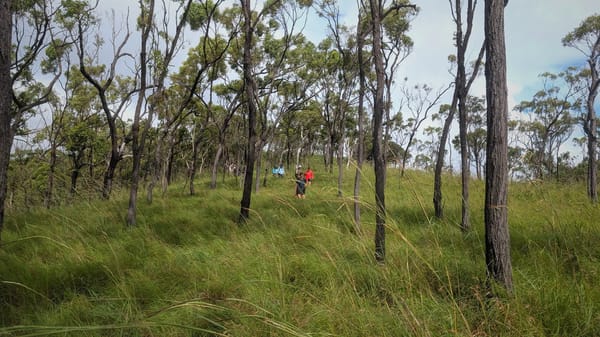
Leaving our car at Olufsons gate we began our ascent of Spur End, 2,500 ft. Our heavy packs felt like lead, however we made good progress and gained the ridge top before 9 a.m. Here we boiled up for smoko and experienced a complete white out due to the early morning cloud cover. When this cleared away the sky was left very overcast and we could walk in less trying conditions. Not expecting to find any water along the ridge lines we were carying 2 gallons each and the extra weight became quite a drag. Moving on over three rock bound knolls we obtained inspiring views out across the Majors Ck. valley. This creek drains the western section of the Nat Park and has carved out a valley over half mile wide through the granite mass. The party then passed through the deep saddle separating Surprise Ck. and a tributary of Majors Ck. This is a steep saddle and we lost and gained about 500 ft. Seen from a distance this valley seems to divide that end of the range in half and is also a vegetation dividing line. After gaining the next high point we followed the ridge gently downwards to a spot where I had planted a gallon of water the previous weekend. Time 12.30 p.m. Altitude 3,000 ft. Large jumping ants about one inch long were noted, colour black. Those with a red colouring on the rear inflicted a savage bite, whilst those with yellow colouring did not bite at all.
After lunch we followed the ridge-line down, then after crossing a shallow saddle we began a steep climb towards the highest point on the Western Spur. Half way up the vegetation changed, trees became thicker and larger, and the whole forest floor covered with bracken up to 3 ft. high. Two scrub turkeys were disturbed on the ground. The ridge then levelled off with a long gentle rise to the actual top 3,600 ft. The top is quite broad and has a few house size rocks dead centre which seems to be a feature of the Elliott peaks. Here we were treated to the visual and physical effects of a violent thunderstorm and were soon soaked to the skin. Pressing on down-hill again we soon passed over two more minor high spots. This section was moderately scungy, mostly young springy she-oak and eucalypt regrowth. Due to the poor visibility we now went too far along the ridge and missed our connecting saddle. After losing about 40 minutes on the side of the hill the saddle was regained and we ascended our final ridge for that. day. A. Aitken and myself now suffered short attacks of cramps and both required frequent stops. Nearing the top of the ridge we began making calls which were soon answered by the other party. They had arrived at 4 p.m. claiming to have had an easy trip but our party was quite tired on arrival at 6.15 p.m. Camp was pitched in a casurina forest in very overcast conditions. The night later cleared up and stars and moon appeared, casting an unreal effect across the limitless, golden bracken. Large jumper ants and scrub ticks proved a trap for the unwary. Altitude was 3,300 ft. and we became quite cold towards morning.
Sunday dawned bright and clear, and after exchanging direction hints etc., our party left at 7 a.m. After a little uncertainty we picked up a saddle with left hand twist. This lost us 600 ft. then we gained another 200 ft. over a small peak. We then lost another 400 ft. and began a long climb up to the next peak. The whole area was still covered with thick timber and deep bracken growth, the ground underneath being very spongy from the leaf mould of the centuries. From the next summit we could look across the gap betwwen Majors and Cockatoo Cks. Great masses of rolling dbud were funnelling up from the coast side over the gap and on into Majors Ck. A spectacular sight viewed from 800 ft. above. The party now began traversing the long undulating ridge which forms one side of Cockatoo Gorge. A new and intensive turkeys nest was discovered, and photographed. After slowly losing height for about 2 miles the heavy forest faded out and the ridge became grass covered again. We enjoyed unrivalled views of Alligator Ck. valley, Cape Cleveland, Saddle Mtn. etc. Lunch was taken at 11 a.m. using some tepid water found in a rock depression.
Dropping off sharply we then traversed the Beehive Bluff, a great 2,200 ft. outcrop of granite with sheer cliffs on the east side. The heat was intense out in the open and we were forced to slow our pace down. With our goal now in sight we lost altitude on the lower ridges and followed brumby pads straight to the Alligator Ck. Picnic area, which we reached at 2.40 p.m. We had a pint of water each left. The last 2 hrs. over the hot open country had required far more energy than we used going from peak to peak in the forest country.
Summing Up:-
Total Distance walked : 17-18 miles.
Total climbing : Approx 6,000 ft.
Highest Point : 3,600 ft.
Walking time for Saturday 10 hours.
Walking time for Sunday 7 hours.
Each walker began with 1½-2 gls. of water as none can be obtained on a ridge line traverse.
The area between Surprise Ck. and the north eastern face of the spur may once have been rain forest and would be very lush after rainy seasons.
The alpine heather extends along the ridge crests for over 6 miles and open patches are covered with fores blue grass.
Connecting saddles were often found to be indistinct when leaving the ridge top but all form into a narrow ridge between creek heads.
There is definitely no large area of rain forest on the western spur as as shown on the Elliott Special Map.
SHARP ELLIOTT TO MT. ELLIOTT.
27/28-2-71.
Leader: P. Reimann.
A long term ambition of the Club was realised during this weekend, with the first traverse of the entire eastern range of the Mt. Elliott Nat Park. This was accomplished by a party of seven members and visitors. The walk began at 8 a.m. from a cane farm at Double Ck. The morning was spent climbing the long spur leading onto Sharp Elliott, 3,850 ft. This was reached at 1 p.m. after a humid, energy consuming trip and the party were glad to enter into the comparative coolness of the dense rain forest. Using compasses we then began following the ridge, our next objective being the high bluff marked "Shoulder" 3,350 ft. The ridge was found to be generally level with true rain forest cover and containing the occasional open forest tree. A unique feature on some narrow parts of the ridge is that the crest is an open gap between the jungle and covered with forest blue grass. Travel was much easier than expected and the party averaged one m.p.h. during the afternoon. When encountering fallen trees and undergrowth where light had penetrated we adopted a policy of losing height and passing them on the north eastern side.
At such an elevation, often within the clouds, conditions were cool and pleasant under the rain forest canopy. Some sections were carpeted in green leaves, probably blown down by strong winds from cyclone Gertie. Due to the cloud cover we did not get many views of the surrounding country.
Camp was pitched along the ridge past the shoulder at 6.20 p.m. Mist and cloud drifted through the clearing and lighting a fire became a major task. During the night the temperature fell considerably and we also experienced a heavy shower. Pigs were heard digging in the jungle only yards from the camp. After dark the ground seemed to sparkle with a million pin points of light due to dead leaves which were probably affected by some fungus growth.
Sunday 28-2-71.
We awoke to a light drizzle which fortunately cleared at 8 a.m. The party began walking at 8.10 a.m. Progress was again by compass and the unerring judgement of P. Reimann. Water containers were replenished from tree root hollows and palm fronds. Numerous pig wallows were seen and we estimated a large population as they have turned whole ridges over with their activities. Various fungi growth were seen, usually of a coral shape and of many colour hues. After a long undulating stretch we began a long climb onto the Elliott summit plateau. Once onto the plateau we made good progress keeping the high ground to our left. We were surprised by the broadness of the ridge which may be one third of a mile across. No trig point was discovered as indicated on the map but many gaps occurred where one could have been placed years ago. Many old scrub turkeys nests were sighted and also two pigs. After a mile on the plateau the party reached the 4,000 ft. high point of the summit. General elation occurred over our successful completion of the eastern spur. Time was 12.30. Due to the overcast we only had a short stop for lunch before descending the mountain, reaching the floor of the Alligator Ck. valley at 5.15, and rejoining the pick up vehicle at 5.45. Walkers were : P. Reimann, P. Biddle, E. Kelly, L. Darvenisa, R. Mooney, Ken Cross, and John Grimes.
Summing Up:
The walk was a complete success despite the wet conditions and the fast pace which had to be set. To comfortably traverse the area requires three days which would give more opportunity to study the wildlife and vegetation. This walk is an experience completely out of this world and it is almost incredible that such conditions exist only 20 miles from our doorstep. After leaving Sharp Elliott the ridge twists considerably and great care is needed to keep picking the direction of the high ground. A cane knife is not a neccessity but a compass is! In dry conditions no water is available without losing altitude into the side gullies. Clear streams are met with on the summit plateau. A well defined animal pad ran for miles along the ridge and the party doubted that it had been made by pigs. Apparently wallabies must traverse this long route over the range.
- THE LOST WORLD. -
A still dawn breaks o'er Elliotts strange land,
Misty clouds drift up from the valley below,
The night shrouds are pierced by a sunrise so grand
A rare sight that only keen bushwalkers know.
Strange stirrings on the high western spur
Natures children have eaten and shoulder their packs
They begin a great push through bush, bramble, and burr,
These strange human beings, that don't need a track.
Day draweth on and noontide is near,
They've smashed the scunge and loya vine,
And taken rest neath the she oaks clear
For they're walking in the burning summer time.
The Day is spent in a long traverse,
From Spur End to the North East face,
On a range that's seldom walked across,
A high and wild, enchanting place.
Now listen friend to that sighing breeze,
O ares sing the tall hoop pines,
And perhaps you'll learn the secret
Which millions cannot find.
LOCAL HISTORY ETC. :-
It is of interest to mention a trip by an intrepid T.R.E.B. "radio site seeking" party, undertaken in the early 1960's. There were four in the party and they started from St. Margaret's Creek, traversed the top of Alligator Ck., climbed Mt. Elliott, then travelled the ridge towards Sharp Elliott from which they descended into Majors Ck. as an escape route. They made contact with civilisation at Olufsons farm in the valley entrance.
Time taken was an overdue five days and in the latter stages police and air search were called upon. Water was not taken and harrowing stories are told about draining moisture from lengths of vine. (The green ones are very bitter apparently.) The huge areas of vines were a great hindrance to the party.
Two plane crashes have occurred on the range. One aircraft remains somewhere in the jungle on the steep slopes on the southern side of Majors Creek. The Field family of Woodstock have an idea of its whereabouts. The pilot Captain Taylor bailed out on the eastern side of the range and landed near a great outcrop of rock on the side of Cockatoo Gorge. He spent 3 painful days getting down to William's farm at Alligator Creek, but lived to fly again.
The other plane is a wartime mosquito bomber, which crashed with the loss of crew on the eastern slopes of Saddle Mtn. All the bodies and also some of the instruments were brought out. Although the approximate position is known, it is thought that the plane, of mostly timber construction, has now disintegrated into the jungle.
Remains of small weirs can be found on St. Margarets Ck., and on Sandy Ck. Fluming and the occasional bent pipe are all that is left. A hydrological survey of Majors Creek was carried out recently by the Irrigation and Water Supply.
While the natives usually did not frequent the high mountain areas, beleiving them to be the home of evil spirits, they undoubtably roamed the lower slopes and creeklines.
FACT OR FABLE.
The Club has received many reports of a quite large lake in the range area. However we have now completed all major walks of ridges and valleys and proved to our satisfaction that no large pool of this size exists. However many places exist where rockslides etc., in the past could have impounded a great amount of water. Mr. Neville Hill, Olufsons son in law, once flew low over the whole area and could not see anything resembling a lake. Still the rumors persist. What was there back in the past? It is also reported that deer lived in the area. We have not recorded any deer sightings, but I personally believe that they were there. Long term residents of Barringha, Woodstock, and Majors Ck., all lay claim to this.