Newsletter October 2020
October 2020 newsletter shares upcoming North Queensland walks, Paluma updates, COVID-19 changes, club news, bushwalking resources, and recent adventures through creeks, waterfalls, rainforest, and rugged local ranges.
G’day and welcome to the Townsville Bushwalking Club October Newsletter.
Walk Schedule
3rd Oct Saturday one day walk – Bullocky Tom’s track / Gold Creek Falls 3-5th Oct Long weekend 3 dayer – Paluma Range traverse
11 Oct 20 Sunday one day walk 25 Oct 20 Sunday one day walk 8 Nov 20 Sunday one day walk
There will likely be unscheduled walks on other dates, keep an eye on social media and emails.
New Members – welcome to our new members who recently joined the club. Club membership currently is at record membership in my time in the club since 2007.
Social media presence – the club has enhanced its social media presence. We set-up an Instagram account earlier in the year, and that is now active. Facebook, website and email continue to be key communication sources. For photo sharing, in Flickr we also have two groups (one public, one private for members only) – anyone can post photos to the groups. If you wish to contribute to any of the social media platforms, contact the club by email or through the relevant platform.
Monthly Meetings and COVID 19. The club meeting room remains closed, consequently no monthly meet and greet / planning meetings can be held until further notice. The committee has been meeting at coffee shops (complying with COVID19 directives) or on walks.
If you are unwell, have any symptoms or have/meet conditions /restrictions listed in QLD Health Directives, please do not attend club activities.
Xmas party – we will give some thought about what to do about the annual Xmas party. If C-19 indoor restrictions mean we cannot use a house or indoor function, we may try a camp out e.g. Paluma Dam (may have to book early). In the past we have used house party or camp outs. Will Santa be allowed into QLD without quarantine first ?
Paluma Push is on 11 Oct, recommend avoid trying to drive the Paluma area when the Push is on – road is closed for a period of time. http://www.palumapush.com.au/
Mt Spec Rd road works closure (unrelated to Paluma Push)
NIGHTWORKS MT SPEC ROAD CLOSED SATURDAY TO THURSDAY 6PM TO 6AM, FRIDAY
7PM TO 7AM. Mount Spec Road will be open for all vehicles from 6am to 6pm Sunday to Thursday, 6am to 7pm Friday, and 7am to 6pm Saturday.
Cairns Ramblers – a new bushwalking club in Cairns. Affiliated with BWQ, therefore a new sister club in our QLD bushwalking clubs family. Reach out and say hello to them. BWQ recently welcomed into our fold a new walking group in Cairns. Cairns Ramblers will focus on running easy mid week "rambles" on mainly official national park tracks. They have just completed their first walking holiday to the Whitsundays . Cairns Ramblers are now a full member of Bushwalking Qld. and are insured under the Bushwalking Australia group insurance.
Other North QLD clubs in our BWQ family include Mackay Bushwalkers Club, Cairns Bushwalkers Club, and Tablelands Walking Club. If you are in those areas at any time, give them a call about joining a walk.
Remote area communications – an interesting newish product that may be handy for those who need remote area or emergency communications widget and can’t afford or want satellite phone. https://www.zoleo.com/en-au/satellite-communicator/
Other options include the SPOTGEN 4 Satellite GPS Messenger. Or the Garmin inReach® Mini Lightweight and Compact Satellite Communicator.
Camping Mt Spec – QPWS are installing toilets at the two remote clearing camp sites in Paluma Range National Park Mt Spec Section.
Resources for bushwalking in QLD and locally
Maps – free on-line digital topographic maps at QTOPO, they are now available at 1:10,000 for most areas. If you use the Avenza app on your smart mobile device, you can download the QTOPO maps in Avenza for live topographic mapping on your device. Or you can print the maps from QTOPO if you prefer paper map (batteries don’t go flat on paper maps). The club recommends always carry a paper map as back-up if you do use smart devices for bushwalk navigation / mapping.
Wanderstories – a great website resource for local bushwalking and exploring. Actually run by one of our members as a personal hobby.
For local tracks try the book Walks, Tracks and Trails of Queensland’s Tropics by Derrick Stone (CSIRO). You may be able to purchase it though Paluma.Org (see Wilfred), if not then try local bookstore or buy direct from CSIRO. The club and its members contributed information, data and photos for the local tracks published in the book.
BWQ Bushwalk database portal – I have discussed with BWQ that we may add some local publicly accessible tracks to the database.
A feral predator-free safe haven for the endangered Northern Bettong - AWC is returning the Northern Bettong to Mt Zero-Taravale (near Paluma), by establishing a fenced feral predator-free area and planning a reintroduction program to commence in 2021.
AWC recently did a webinar on Mt Zero Taravale reintroducing the Northern Beetong, recommended viewing at this link (copy/paste link):
The club enjoys spectacular multi-day bushwalking adventures on AWC’s Mt Zero-Taravale. The club and some members support AWC by regular donations to the conservancy. If you wish to also support AWC (donate/volunteer), or read about what they do nationally, Australian Wildlife Conservancy is the largest private owner and manager of land for conservation in Australia, protecting endangered wildlife across more than 6.5 million hectares in iconic regions, please visit their website: https://www.australianwildlife.org/
What have members been up to ?
UFOs at Paluma – yep, UFOs have recently been spotted above Paluma. Too many and too fast to be satellites. Involves one of our members – what was he drinking ? But, fair dinkum, it is real ! https://paluma.org/2020/09/a-string-of-ufos-over-paluma-or
Luen has conquered all the named peaks in Bowling Green Bay National Park. Fantastic effort. Check it out at https://wanderstories.space/
GT, LW, and AD completed Mt Bellenden Kerr, QLD second highest mountain. Good effort. Apparently the leeches were well fed – 27 on GT ?
Luen has explored an interesting peak walk on Maggie, Mt Paluma, worth exploring. Other members have recently been travelling far and wide, including Cape York, Lakefield
NP, Central West QLD, Lawn Hill Gorge, Gulf Savannah, Chillagoe, Cooktown area, Simpson Desert and Hinchinbrook Island.
Cape Cleveland Lighthouse aftermath – someone found a souvenir rock in their pack when they got home – was I being accused of mischief ? (not me, I’m innocent - it must be the other prime suspect !) Maybe it is a special Cape Cleveland Harden Up rock ?
Farewell – Aaron has left town and asked for his farewell message to be passed on to members:
I have recently accepted a position in dusty old Moranbah and will be relocating over the next few weeks. I wish I had the chance to say goodbye to everyone in person but things are moving faster than expected and I will not able to fit in any final walks.
I’d like to sincerely thank everyone in the Townsville Bushwalking Club for the adventures, laugher, blisters, wisdom (debateable), memories and views. Some of my best memories while living in Townsville have been made on the various walks I have attended with this club.
See you all again, Aaron Hake
Aaron, the club and myself personally wish you all the best for the future, you have been a great asset to the club. Look forward to catching up in the future. Oh, the “wisdom” we shared with you is not debatable – the club’s bushwalking “elders” are very wise, witty, and know-it-all – just ask us :).
Recent Bushwalks
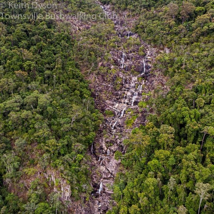
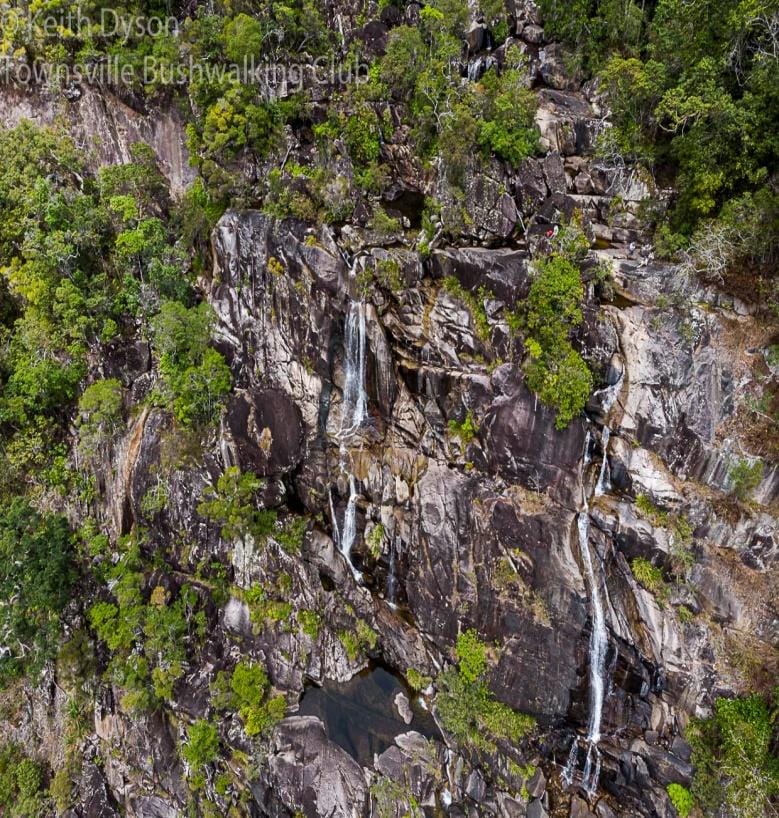
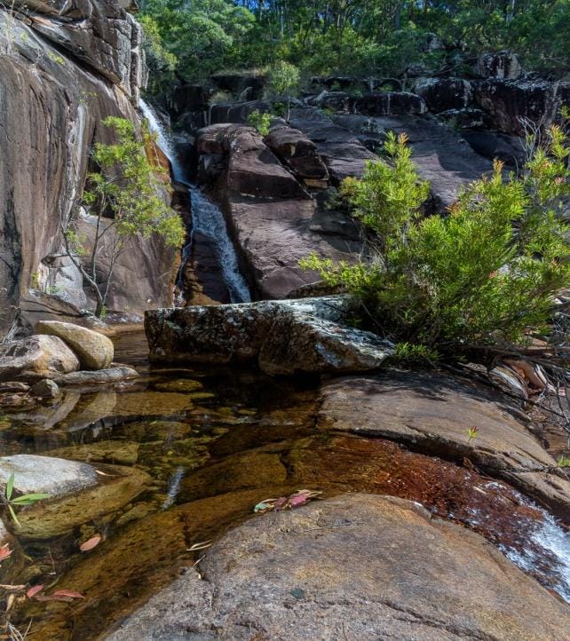
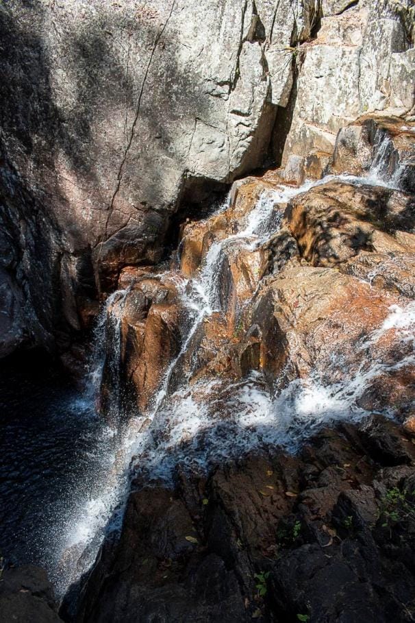
Waterfall Creek, Paluma Range National Park, Mt Spec Section
A great one day bushwalk in a fantastic mountain creek with numerous waterfalls and great swimming hole. Orchids are starting to flower, bottlebrush flowering, nice ferns, great creek scenery. The old timer explorers called this creek a hundred waterfalls in a day. Cascading from Mt Spec down the Paluma Range to Bambaroo, it is one of the most impressive creeks with a steep drop down the mountain side. This is the creek that the waterfalls are visible from the highway at Bambaroo. We hiked from Paluma Dam along forest tracks to the creek, then rock hopped down the creek through many cascades, to the start of the big drop-off at edge of the range. Awesome views, all the way to Cardwell Range, Ingham, and Hinchinbrook Island. We then bushbashed down the side of cascades and waterfalls to sit on top of a great long drop twin waterfall cliff. After lunch at this wonderful spot, then the scramble back up to the top through boulders and jungle, then rockhop up the creek, and the track walk back to the cars. Historically, we have walked all the way down the creek to the highway in a day, some members have abseiled all the way down, and we have tried coming up from the bottom as well. The Army use the creek for “adventure training” each year and abseil down the creek all the way. A fantastic mountain creek. Another great day with Townsville Bushwalking Club.

A wet Paluma
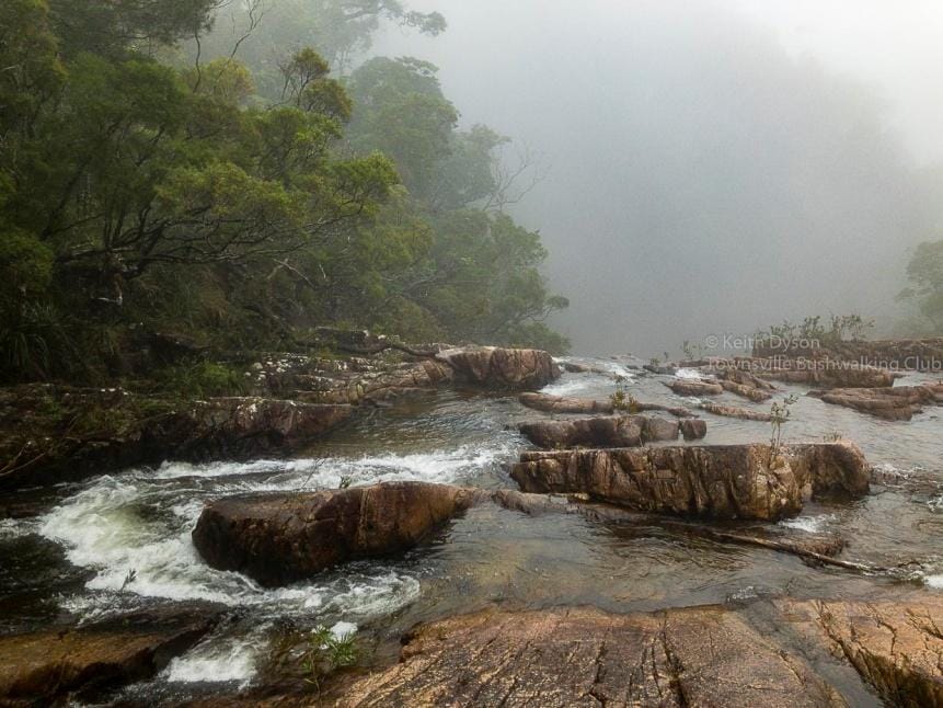
A double header weekend was planned based on Crystal Creek Falls. Saturday the easy track walk to top of the falls, Sunday the harder off-track excursion to the bottom of the falls and lower down the creek. Driving though Paluma on a misty Friday arvo, I spy a wise elder digging for gold road side – well, he was digging holes, and knowing him, what else would he dig for ? Quick chat about weather, he said “ya know, the sou-easter wind, always brings rain up here, going to be wet for your walks”. – “Nah, weather forecast is good for weekend” I reply (it had been raining about 15mm per day since Wednesday in the mountain range). Driving towards the dam, rain starts. Quick photo-explore of the two Birthday Creeks in the rain, then to camp. Drizzle persists. Then more rain - in a 20 yr old leaky tent. 6:30 pm decide to leave tent there and escape for the nite, come back in the morning, but tree down blocked the road out. Back to camp, and heavy rain, then very strong winds for part of the night. When did the fun start ?
Saturday's Rock Garden / Crystal Creek falls walk was wet. Wet. Wet. Four days of rain on Paluma ranges, meant very wet rainforest, misty, and slippery rocks. A nice walk in moist misty rainforest, very ethereal. QPWS has installed signage to Crystal Creek Falls, so it will become more popular no doubt. Rock Garden was mystique in the moist and misty conditions. At the creek, increased waterflow and very slippery rocks. A magical scene in mountain mist. So we stayed around the top cascades and at the pool. It was not viable to go to the main waterfall. A nice walk back to the dam, where it started to rain. So pack up camp and head home, need new plan for Sunday as the planned walk was too risky in these conditions.
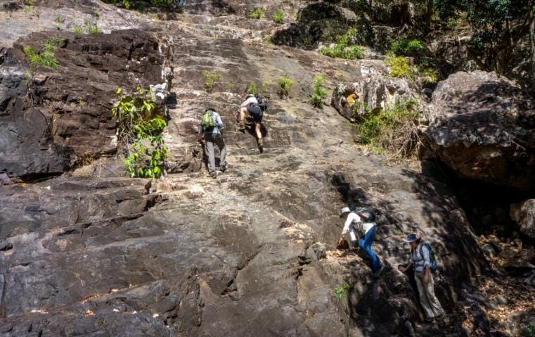
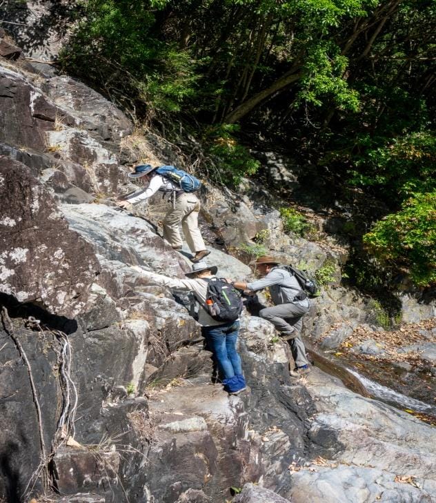
North Creek, Mt Elliott, Alligator Creek Section.
Sunday, changed location to North Creek, another club favourite and one of the best creeks anywhere. A pleasant mountain creek walk with good waterfalls and pools as usual. Great swimming. Orchids starting to flower. Good challenges for those not used to waterfall rockface climbing and exposed ledges. At one rockface, where we use a 'hand rail' embedded in the rockface to assist traverse the rockface, well, the handrail crumbled in my grasp - no more handrail. So that makes that particular rockface traverse more challenging now. From the various choices of route home (North / Cockatoo / Orchid / Horse Ridge etc), we chose to see if we could follow the horse trail all the way - we often only follow it half way then do long grass off the ridge - today we did the zig zag horse track all the way - a nice walk off the mountain avoiding scrub and long grass / hidden rocks. Photos – Garry Hutcheson.
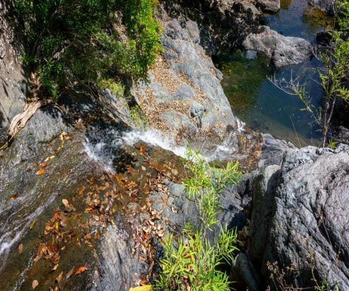
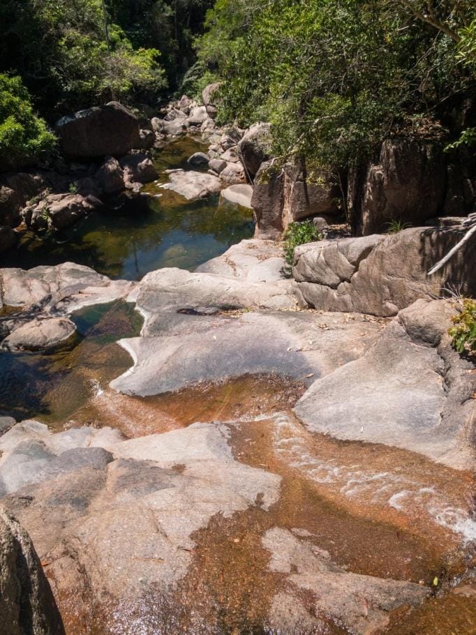
Hencamp Creek, Paluma Range National Park.
A bit late in the year to do this creek, but with recent rain on the range the creek had reasonable flow for this time of year. The usual style creek walk, lot of rockhopping in lower level, then the boulders, then some rockfaces to scramble around, then more boulders. At creek junctions, was asked “which way ?” – “follow the water flow”. It was very hot in the valley, so frequent stops along the way. A good waterfall and swim pool for smoko, then on to the canyon gorge and upper waterfall, a great pool here.
Then the hardest decision of the day – hot chips or ice cream on way home ? It was a difficult question to resolve !
Access – due to the private properties and sensitivities involved on the access we used, the club does not divulge how we accessed the route used. Recommendation is to remain within National Park boundaries and avoid private properties.
A Monster Mountain or a Nice Creek ?
It was time to give a club infamous mountain a crack that hasn’t been climbed for some time. Or maybe we could just relax in the creek with nice waterfalls.
An early start, started walking along a track, supposedly to find a specific creek to enter. After a long walk, no sign of the creek, better go bush. We expected thick jungle, vines, maybe even gorillas and Tarzan to be about. The jungle wasn’t too bad, forest canopy was good here. After 2 hrs, we found a creek, this was it. Then the creek rock hop / boulder scramble upstream, but overnight rain meant very slippery conditions and slow going. We tried to go bush, but along the creek there was no forest canopy, therefore thick wait-awhile, tangled vines, and stinging tree (Gympie Gympie) impeded any progress. Back to the creek and slippery rocks. At midday, still a long way to go, we called it quits due to the slippery conditions and slow pace. Heading downstream, we found nice waterfalls and creek scenery. Downstream the rocks dried out after midday, so easier going during the afternoon in this nice part of the creek. Although, we did comment “this is a very long creek, when does it end?” as it went on and on and on. We caught glimpses of the sheer mountain side cliff face (up to 300 mr cliff face sheer drop apparently). Back to the cars, the esky with icy cold drinks was very welcome. As we drove away, the mountain glared down upon us, whilst we gazed up, thinking, next time, we will get you.
Someone talked for 4 hrs about hot chips – drove me insane, I was drooling (and I never got any, had to settle for ice cream). Later I was told she had sweet potato hot chips at a highway stop that were very yummy – damn, I’m still drooling. But, my mango / pineapple double ice cream, was very satisfying and good substitute.
But compare to a 1970s club walk, the group split in two leaving second group with no car, who after the tough mountain range traverse and getting down in the dark, then walked further 25 km to a town arriving 2 am, to catch the 3 am train to arrive in Townsville 5:26 am. They were tough in those days !
The name of the mountain range will be revealed in the future :)
(p.s. talking about hot chips on bushwalks is now banned !)
Raspberry Falls – an interesting tid bit of info, some think Raspberry Falls (Mt Fox) is a recent addition to the regional bushwalking scene. As a known bushwalk it was used many years ago, even by the club, and RB says that the Ingham boy scouts used take the kids there for walks, no track in those days, and they did not slosh down the creek either. The scouts even had a taped route ! So what some think is new, is old :)


