Aussie Ten Peaks
Aussie Ten Peaks in the Snowies: 130 km/h gusts, –5.5 °C, zero visibility and a ‘shortcut’ that maybe wasn’t. Seven summits on day one, two in a gale on day two, and a blown-off finale. Brutal, hilarious, unforgettable—definitely not a circle. Probably.
“Are we walking in circles............ ?”
“No, of course not, this is a short cut” “I think you have led us in a circle.................................................... ”
“No, no way – this is a shortcut to the top, trust me”.
“We have zero visibility, how do you know where we are, or where we are going ?” “Look, just ahead, around the corner, and we will find the Kozzie track, trust me”.
Winds gusting to 130 kmh, temperature minus 5.5, zero visibility, heavy rain. When did the fun start?
Paluma Dam, sitting in the dam cooling off after Shays Clearing / Diorite Falls bushwalk, on a hot tropical day. Two girls sidled up beside me, one either side, close in.
“We have a proposition for you” they say, as they move closer. Intimidating.
“When can we do it?” they ask. Now I am worried. “I need time to prepare for the performance, maybe later in the year ?” I respond.
”No, we need to do it sooner – when is best time ?” they persist “Can we do it now?”.
“Well, right now is best time, but I can’t do it for another month, so how about mid to late March ?. Or, someone else can do it with you ?” I respond.
Alas, I am the intended victim, no escape, and they are keen for March. And so, the genesis of the Aussie Top Ten Peaks challenge was born. Actually, it is eleven peaks, as two are equal height.
Why me ? Well, at Xmas I did five of the top ten, walked the Main Range, therefore knew the area, and had unfinished business to get the other five peaks.
Plan was a three day hike, 52 km, and do the Aussie top ten peaks, all in the Snowy Mountains Main Range / Kosciusko area. I did start planning as two day hike and with tighter travel times, but decided to allow time to enjoy the trip and for contingencies. Weather during March had been nice, but as our dates approached the seven day then three day forecasts became bleak.
Thursday 22 March
A group of four of us, fly to Canberra, hire car and drive to Jindabyne, stopping at Cooma for gas cylinders and lunch. At Jindabyne buy the national park pass for the car, try to submit Intent Form with NSWNPS but that was too hard for them. Then to the pub for happy hour and the condemned’s last meal.
Friday 23 March Day 1
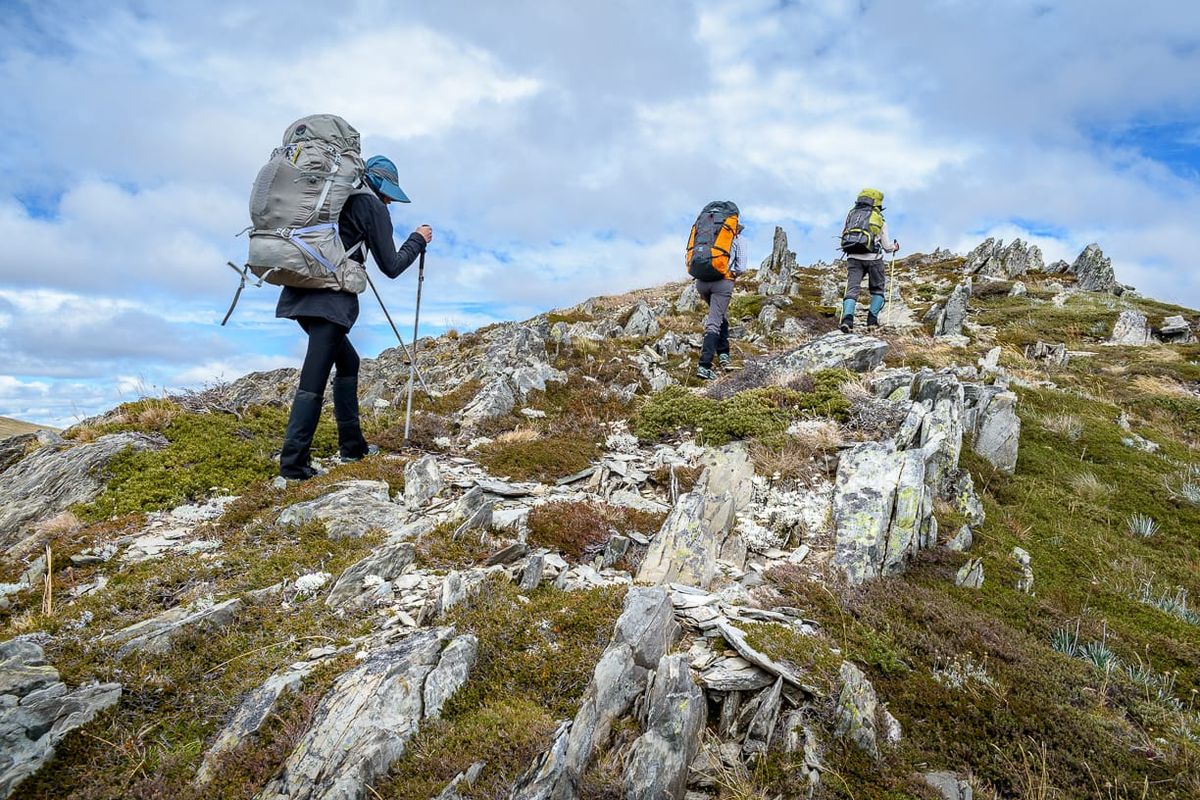
Seven peaks. 25.6 km. 1331 mr ascent, 1260 mr descent. Elevation minimum 1733 mr, max 2209 mr.
Depart Jindabyne. To the east, nice sky. To the south and west, bleak – and we are going south west. Driving up to Charlotte Pass, there is nervous negative energy from one, and sheer excitement and joyous positive enthusiasm from another. “Look, fluffy white clouds blowing away, and sun about to shine, it will be a lovely day”. “Yes Joy, but we are going in the direction of those big dark clouds ahead “. We drive though light rain.
Arrive at Charlotte Pass, enveloped in cloud. Packs on, procrastinating about wet weather gear or take the risk. Is this mist or rain ? An easy start to the walk, low visibility in cloud, down to cross the mighty Snowy River. Water level is low so an easy rock hop crossing. That was the easy part. Then the long hike on the track, all up hill, with 20 kg packs on. As we hike, the cloud starts to burn off, and it looks like a nice morning ahead. A reprieve from uphill, as the track descends to cross a creek, then uphill again, the grind goes on. KG was enjoying (not) this uphill grind with the pack on. A track junction, I take them downhill to a special spot – Blue Lake. “Why are we going downhill to a bloody stupid lake” I am asked. And not just once. “We are here to do mountain peaks, not stupid lakes” I am told. But I keep responding “this is special, and nice, and you will appreciate it”. Alas, hard to please some. So I only took them to the lookout, and not all the way to the lake outlet (which is really really nice). Going down to the lake outlet, may have caused a mutiny at this early stage.
Behind Blue Lake, is Mt Twynam, our first challenge cross country. But the lake and cirques block the way.
Back uphill to the main track (still with packs on), we trudge higher and higher, as I seek the cross country route I want. If we go too early, risk of getting into rough terrain and those cirques, so we keep going along the track to the saddle. At the saddle, we turn right, and rather than cross country as I expected, there is a foot pad, so we drop our packs, then follow the foot pad (actually part of the Kiandra track) then cross country to Mt Tywnam (2,196 mr), 3rd highest peak in Australia. After a celebration, we return to our packs. Packs back on, then the grinding uphill track climb to Carruthers Peak, equal 9th highest peak. Awesome panoramic views over the Western Fall Wilderness, and views all round to other peaks and valley views. From here can see all ten peaks. The wind has picked up and is getting blustery. After lunch, downhill, then along the ridgeline track past Mt Lee, then climb cross country up to Mt Northcote (2,131 mr), the 10th highest peak. Descend back to the track, to Mueller’s Pass, then cross country down to Wilkinson Valley for our planned camp site,
arriving 2 pm. I selected Wilkinson Valley as it was less exposed for camping than up at Mueller’s Pass, and easier for water resupply. That was all that was planned for today. But as we are early, and the weather forecast for next two days was not good, we decided to do the four peaks of Abbot Range above the camp, a nice 4 or 5 km round trip. With no packs it will be a doddle. There is a track to Mt Townsend, so all will be good.
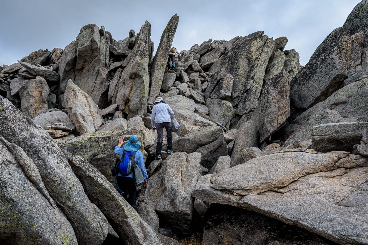
We start the climb out of the valley towards Mt Townsend, walking in alpine heath and amongst rocky outcrops, seeking the footpad track that lays above somewhere 1/3 way along Mt Mueller. This turns into an uphill cross country slog, no sign of a track. Cursing thrown my way about the mythical track that I boasted about. But at the saddle after a hard grind we finally find the footpad. Then the 60 metre scramble up the granite tor outcrop, to the top of Mt Townsend (2,209 mr), the 2nd highest peak in Australia. Not many come here. A good celebration and much happiness. Then down off Mt Townsend, 1 km along a ridge over rocky outcrops, to Alice Rawson Peak, 7th highest (2,167 mr).
We cross the western side of Mt Townsend, contouring, in denser alpine heath and rocky outcrops, often finding unseen holes to fall into, or slip and slide on silky grass, to get around Townsend and reach a saddle. Imposing, above is a peak – but is it one of the top ten ? By now I am fatigued, and do not want to do any more climbing unless we need to. And this peak in front, I do not want.
Apparently my face expression said it all. Study the map, I try to dismiss this peak above, but it is one of the ten peaks, despite my wishing it away, so up we have to go. Damn. Struggle in the alpine heath, slipping and sliding, fatigue has set in, then onto the rocky summit climb which was actually easier clambering up steep rocks, then we are the top of Abbotts Peak (2,145 mr), equal 9th highest. A short walk across to the next peak, unnamed (2,159 mr), 8th highest peak. Much happiness and smiling all round. And beautiful late afternoon sunlight, a magic moment. We have achieved seven peaks in one day (plan was three). We then head downhill, back into the valley to camp site, arriving about 6:15 pm. We are exhausted but very happy. A 25.6 km day, seven peaks, with 1,331 mr ascent. We set up camp, still had energy to inflate the mattress, and relaxed under the stars. The Milky Way shone brilliantly, a beautiful night. We tried to convince WK that he should have a ‘refreshing’ bath in the creek, but he was having none of that.
Saturday 24 March Day 2
Two peaks. 15 km. 529 mr ascent, 573 mr descent. Elevation minimum 1851, max 2228.
Clouds surround the valley. Rain at 6:30 am, but it only lasted five minutes. The revised plan now is the last four peaks, camp at Ramshead Range, and an early retreat on Sunday morning to beat the really bad weather forecast. Or maybe after the four peaks hike out late in the day or evening to return to Jindabyne tonight. We break camp, and at 8:40 am start the hike out of the valley. Visibility decreases, and light misty rain falls. We follow an old track out of the valley, which is the old Hannels Spur track, that should join Main Range Track at Mueller’s Pass according to the map. But in reality, it diverts and does not join, but is a short cut to Mt Kosciusko track – kinda, I think (I had been eying it off from other peaks the day before). In the mist we follow this track, climbing steeply, much to KGs joy (not) “Straight after breakfast you make me slog uphill with full pack – thanks a lot”.
Conditions deteriorate, visibility is poor, and the track disappears – just ceases to exist suddenly. We continue uphill through heath. We are blocked by a rocky outcrop that looms out of the mist, we go left. I know the Main Range Track is not far away on our left if we need it, but I want to short cut to the Kosciusko track by going right. After a while, we stop for a break, put on more wet weather gear. I check map and GPSr, we are 400 metres from the Kosciusko track junction. We continue on, barely seeing 10 metres ahead. We are blocked by another rocky outcrop. I check map and GPSr, we are 395 metres from the Kosciusko track. Strange.
“Are we walking in circles............ ?”
“No, of course not, this is a short cut” “I think you have led us in a circle.................................................... ”
“No, no way – a shortcut to the top, trust me”.
“We have zero visibility, how do you know where we are, or where we are going ?”
“Look, just ahead, around the corner, and we will find the Kozzie track, shortcut, trust me”.
We continue, then I look to our left and 10 metres below is the Main Range Track (why was it so close ?) – “I think we should aim for the Main Range Track now” I state. And point at it below.
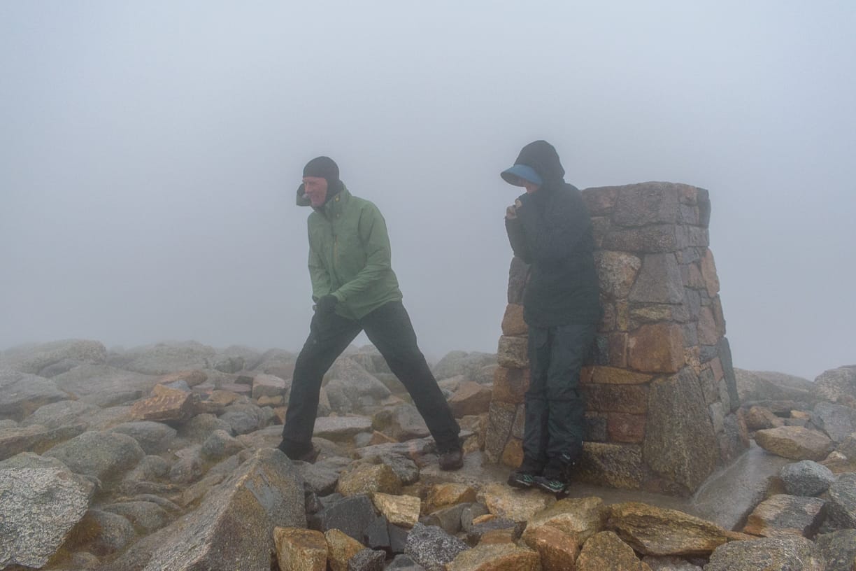
Happily, we are now on the main range track, and a short uphill hike to the junction with the Kosciusko track. Then 900 metre uphill walk in roaring wind and rain along the track to the highest peak in Australia, Mt Kosciusko (2,228 mr). It was very strong wind, cold and rain, almost no visibility, so not much celebration at the summit. Made a quick phone call to Jindabyne to book accommodation – we were not camping out as planned at Ramshead tonight in this weather. We quickly walk back down off the summit. Enveloped by cloud, wind and rain, we hear creatures calling in the mist – Bunyips. They loom out of the mist towards us, black creatures scurrying past us towards the summit. Short while later we hear, then see, more emerging from the mist, but these are furless pink skinned creatures looking very cold and wet, also heading for the summit. A Bunyip convention at the summit on a very cold, wet and misty day. Only Bunyips would be out in this diabolic weather, no sensible human would do it, would they ? We reach Rawson Pass and the toilet block. Seek shelter in the toilet block, as others were doing. We add layers of clothing, and prepare ourselves, for what will be a tough remainder of the day. Conditions worsen.
I advise the others that I am not comfortable with going to Ramshead, as it is very exposed, cross country, we have zero visibility, and relying on the GPSr worried me as it was getting very wet. We decide to go along the boardwalk track until it was time to go cross country for Ramshead and make a decision at that point. We were hopeful that conditions may improve. We walked 1.7 km, in blustery wind, I was blown off the track by a gust of wind. WK thought maybe I had too much port last night. At Lake Cootapatamba lookout (highest lake in Australia at 2,046 mr), conditions were horrible and no visibility. We decided that it was too risky to try Ramshead, and so time to retreat. But, Etheridge Ridge was nearby, and that was a target, so decided to give that a go as I have been there before, it is a short walk only, and I was confident it would be okay to do. We went cross country up the ridgeline, clambered over rocky outcrops that were false summits, until we found the summit hiding in cloud (2,180 mr), 5th highest peak. Rain was stinging our faces (JS and I thought some of it was more than rain), it was cold, strong winds, hard to stay upright – so not much celebration and no group photo. We then made a hasty walk off the ridge back to the Rawson Pass toilet block. Then the 9 km Summit Road walk, past Seaman’s Hut, over the Snowy River bridge, back to Charlotte Pass. We were happy to be back at the car. A 15 km day, two peaks, 529 mr ascent. But that leaves two peaks still to do .........
Highest wind gust 78 kmh, temp 9.9 (air), apparent (feels like) 1.4. Lunch at Trader Joes at Jindabyne – the biggest burgers and wraps ever.
Sunday 25 March Day 3
Weather forecast is horrible, worse than yesterday. The Threbo chair lift had operated yesterday, so we have a new plan - use the chairlift to Eagles Nest (Thredbo Top), then quick cross country hike with day packs to Ramshead, do the two peaks there, back to the chair lift, all good. At 8:30 am at the chair lift office – it is on wind hold, winds recorded at 111 kmh up top. But they are hopeful it will operate later. We hang around for an hour, but still on hold. At 9 am, wind gusts of 130 kmh recorded up top. BOM forecast said normal winds 72 kmh gusting to 104 kmh. At 10:30 am air temp 9, ‘feels like’ minus 5.5. Visibility was poor up top. We go back to Jindabyne. Trees along the road were blowing madly in the wind. Midday we drive back to Thredbo. Chair lift is still on wind hold.
Now heavy rain had set in as well (60 mm forecast). We drove up to Dead Horse Gap, and contemplate whether the 7 km one way hike up the 700 metre ascent to Ramshead in 100 kmh
wind, heavy rain, and poor visibility, was an option – it was not. Back to Thredbo, at 1 pm they cancelled the chairlift for the day. In a way, we were thankful. Return to Jindabyne, late lunch, we mull what to do. We spy hills on the other side of Lake Jindabyne, and one has a trig marker on it. We go for a drive, the main road passes near its summit, and a quick walk up the hill and that is peak number ten – the rock at top even simulates Ramshead – that will do, ten peaks done !
Dinner at Banjoes Inn – the girls can’t wait and go ahead to pre-celebrate. We join later. Several $35 bottles of celebratory bubbly are consumed over dinner, making for chirpy talk, and future ideas.
Monday 26 March
A sunny but chilly morning at Jindabyne. It has snowed on the ranges during the night. At midnight winds of 117 kmh recorded at Thredbo Top. At 9 am air temp at Thredbo Top was minus 3, ‘feels like’ minus 14.4. We drive back to Canberra, seeing snow on top of the ranges. While we had two peaks left to do (Ramshead 4th highest and Ramshead North 6th highest) (well, I don’t, I have done all eleven now in two trips), we were satisfied that we did the best we could in the conditions presented. It was a great trip, great company, and well worth doing.
At home, I get a message “did we walk in a circle ?” and a watch GPSr track sent to me. “Of course not !” I reply. I download my own GPSr data to analyse – hmhmhmhmhm ..................... strange ......
oh ...... ok, where is the delete key.................. Deleted - it never happened did it !!!!!!!


