Cape Upstart. Easter Weekend. April 9.10.11-12, 1982.
Explore Cape Upstart on this 1982 Easter bushwalking adventure. From Guthalungra to Snug Harbour and Coconut Bay, hikers crossed creeks, saddles, and overgrown tracks to reach remote campsites with fresh water, sandy beaches, and rocky outcrops—an iconic North Queensland coastal trek.
Easter Weekend. April 9.10.11.12, 1982.
The idea seems to have started in Rockhampton! Lou told us
that the Rockhampton Bushwalkers were planning a trip to Upstart
and somehow we agreed we would go too. Following phone calls to & from
Dave Willis, with an eye over our shoulder at ex-Cyclone "Dominic"
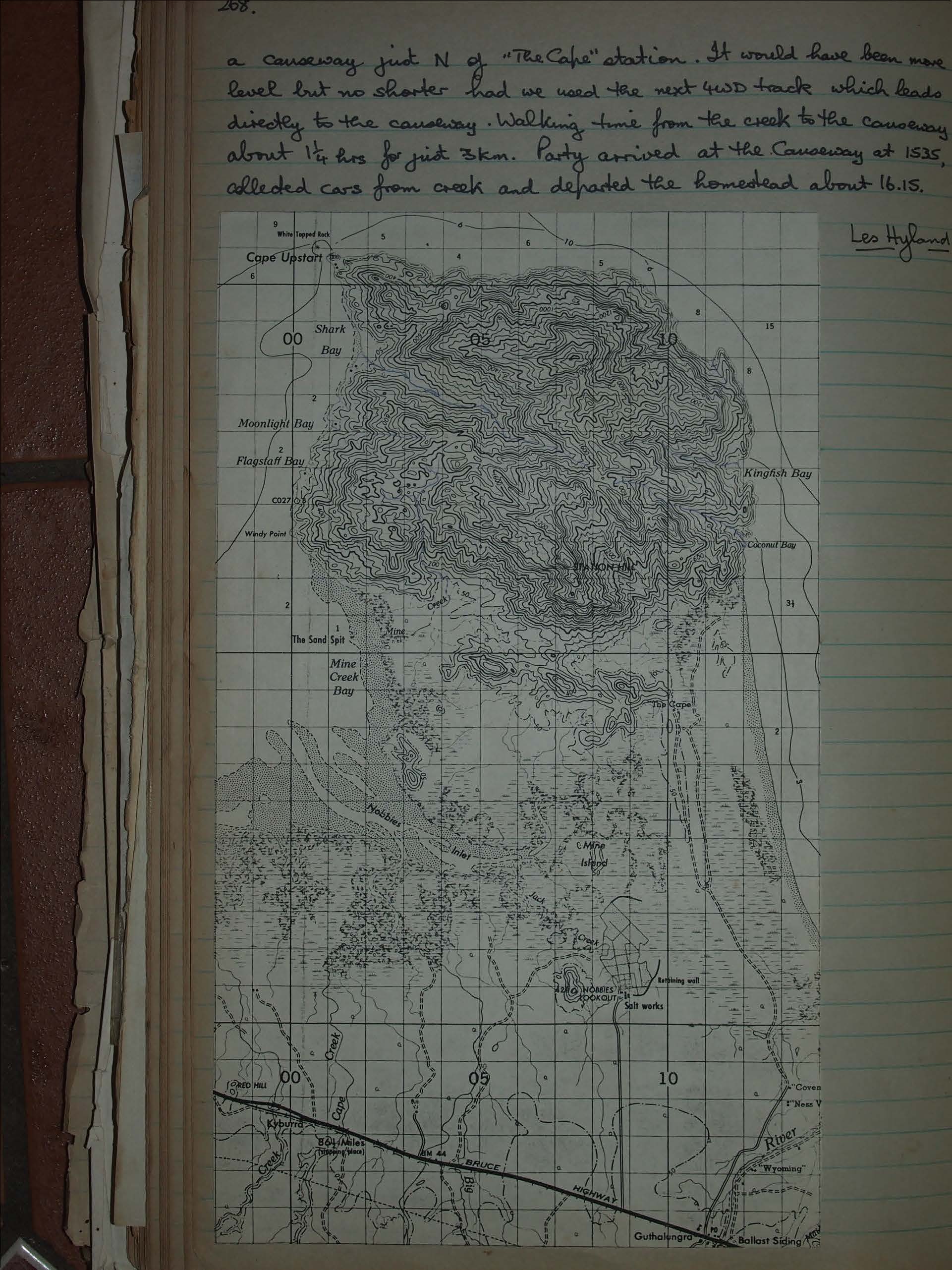
up off Cooktown, we arranged to meet at "The Cape" station on the
morning of Good Friday. Somehow, Lou, Marion, Alistair & Ben got there
a day early and at 04.00 on Friday morning the T's, waded the creek &
were in Coconut Bay mid morning. 14 more Townsvillites met at
Allan Watson's place at or about 0630 Friday, drove to Guthalungra
(161 Kms South of TSV) and turned left on the dirt road just before
the local shop + petrol station. Thence to "The Cape" is 16kms and
four gates away. Townsville was first to arrive, Rockhampton slept
under the Don River Bridge near Bowen and arrived at 09.00 in
Rothery's Midi-coach. Routes were discussed and we opted for the
route on the N.W. of the creek, they for the causeway + the beach route.
We drove on a "farm" road past two dams on our left to where the
"road" ceased at a rocky creek under Station Hill. Rockhampton
had a change of mind and arrived 15 mins later, the bus having
negotiated the "road" even with its small trailer. Our departure
was at 10.10 following an old four wheel drive track, somewhat
overgrown but still clearly discernable. We followed this on the
flat alongside the creek for some 20 mins and it then ascended
sharply with a good viewpoint over the inlet + the creek mouth. The
track became progressively more overgrown and eroded as we
as we continued and stopped for a snack on the escarpment
of the first summit 11.10 - 11.30 apx. From this point the route of
the track over the next spur was fairly obvious. A drop of some 200'
and a similar or slightly greater rise had us skirting the bluff,
track very badly overgrown in places but still not too difficult to
follow. It continues skirting the bluff before dropping into Snug
Harbour and we lost it on the descent, continuing along an
overgrown creek to the lagoon behind the beach dunes. To reach
these we skirted the lagoon to the second, larger, creek which
despite a lack of rain was still running sluggishly but
N. of the beach. At this point we had covered only just 4Km in some 2 1/2 hrs walking (excluding stops) but pace was only moderate as despite some cloud cover it was very hot. At Snug Harbour (N.B: The names used in this account differ from those used on all current R.A.S.C maps which have "Coconut Bay" for Snug Harbour, "Kingfish Bay" for Coconut Bay and leave Kingfish Bay unnamed.) we were joined by Harry Kershaw who had come across the Cape from Shark Bay by way of Shark Creek and the main creek into Snug Harbour. He reported water in both creeks for most of the 1 1/2 day traverse - he arrived just as we did. Rockhampton group arrived some 30 mins after us, having left later. After lunch we crossed in two groups to Coconut Bay over the 400 ft saddle using the creeks on either side. Going was not difficult, a bit overgrown in spots, route obvious enough + completely dry. Time taken 1 hour distance under 1 1/2 Km. Camped in grove of trees at S end of bay, not far from the dry creek we had descended. The Bay is divided sharply in two by a rocky outcrop. The South end is fine sand, the North boulders and rounded stones. Fresh water is obtainable only in the North end about a 20 minute walk each way across the rocky outcrop. Three creeks enter the N. end of the bay of which the middle one carried a fair flow. This was walked on the Saturday and rises fairly steeply about 1/2 Km from the sea with three good sized pools, suggesting water availability at all times except the very last months of the year. The parties returned on Sunday + Monday at different times, all by the saddle to Snug Harbour and the rock and beach route to the tidal creek. Four walkers attempted Station Hill via Snug Harbour, its creek and the Northern ridge. No details available. The Townsville group left Snug Harbour at 13.40 on Monday 12th and crossed the tidal creek early (waist deep) at 14.20. On this date the tidal variation was slight with a HW of 1.7m at 10.42 and a LW of 0.74m at 16.06. Tide as at "Cape Upstart" in Tide Tables calculated off "Standard Port" - Townsville. From this it is clear that unless high seas are running this creek should be fordable at LW at all times; maximum depth 0.7m; and at most times for about 2 hours either side of LW (the exception being a very high LW level). From the creek the group walked along the beach and took the first 4WD track across the dunes to
a causeway just N of "The Cape" station. It would have been more
level but no shorter had we used the next 4WD track which leads
directly to the causeway. Walking time from the creek to the causeway
about 1/4 hrs for just 3km. Party arrived at the Causeway at 1535,
collected cars from creek and departed the homestead about 16.15.
Les Hyland