A rock ............ a big rock ............ Veni, vidi, vici !
Cockatoo Rock adventure with the Townsville Bushwalking Club: a tough off-track climb through boulders, cliffs and rainforest to a granite summit above Cockatoo Creek waterfall. Rugged terrain, stunning views and true North Queensland challenge.
Cockatoo Rock Sunday 27 May 2018
A rock .............. a big rock .............on the side of a hill .........
QUIZ – how long does it take to walk 450 metres, downhill ?
For some time we have been looking at a large granite boulder high above Cockatoo Creek waterfall. Visible from the highway, from the creek at several vantage points, and on Google Earth, it is a tempting teasing beacon for adventurers. Joy demands that we go there – no more talking about, just do it.
Studying the terrain from afar, and maps and Google Earth, looks like it comprises challenging steep rough terrain – cliffs, large boulders (boulder fields), scree slopes, jungle, and a steep climb to 500 metres elevation. So a thought is we could summit the rock somehow, then find a short-cut route down another boulder strewn slope and ‘greenery’ to Cockatoo Creek waterfall for rewarding swim, then walk out along Cockatoo Creek. Sounds like a plan.
We advertise it as exploratory and ‘hard’ – ‘Exact route is yet to be determined, which is why it is exploratory. We will know where we are going, when we are doing it !’
It is only a short walk (distance).
Ok, Joy and Wilfred can lead the adventure to it, all good.
Except ................................
Wilfred has to withdraw, consequences from Walkers Creek. I tell Joy she is now sole leader, but that does not go well. Bugger, that means I am leader !
Five crazy members assemble at 0645 at Alligator Creek day use area for the adventure. Chatter about what gear each has, common is ’have you got headlamp, just in case?’. Oh yee of little faith !
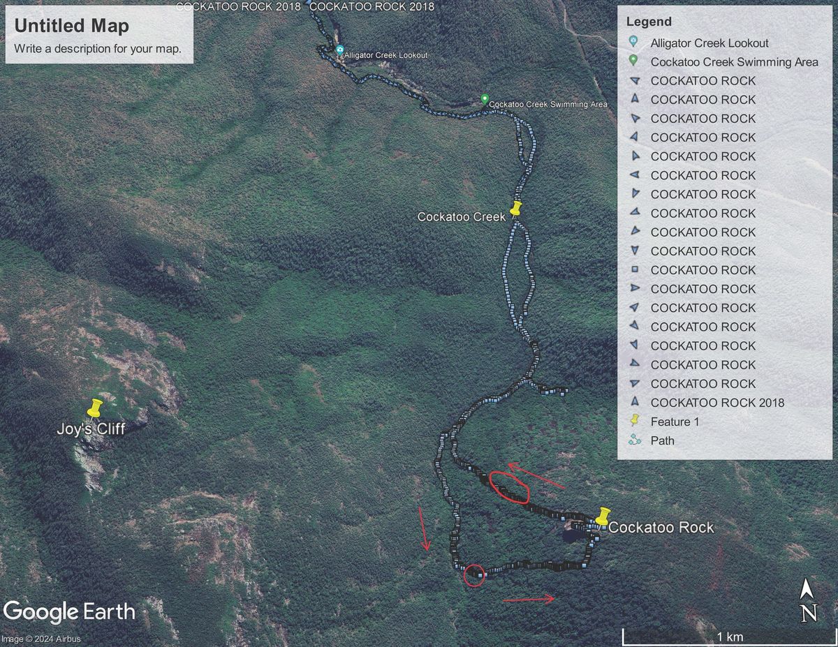
We start walking at 0700, along the national park track 2 km to Cockatoo Creek. On the grass shortcut to the creek, we can see the rock in the distance, dominant, calling. We have two options for this hike going up to the rock – one via a long undulating ridgeline, or one via a side dry creek gully. Other routes look too hard or impassable. I decided to try the side creek gully route. Plan is 1.4 km along Cockatoo Creek, then to go up the side creek to the saddle (800 metres) to avoid the more direct route through boulder field, then sidle along the contour line 550 metres across to Cockatoo Rock. So only a 1.3 km walk when we leave Cockatoo Creek to the rock. Then 450 metres from the rock down to the waterfall. Short distance walking ! Luv it !
So we stay in Cockatoo Creek rock hopping for an hour, avoiding the large wasps nest, until we reach the side creek gully on the left (3.4 km from car park). Now the adventure starts, at 0802.We head up this side creek (I thought we came down this side creek from North Creek many years ago). It is not a clear creek line, but confident it will clear soon, we eagerly push in. Blocked by boulders, tangling vines, scunge, and low branches, we manoeuvre our way along, constantly changing direction seeking the ‘clear’ route. But the ‘creek line’ is too bouldery or overgrown, so try out of the creek, but that is bigger boulders, holes, more vines, and more blockages. We barely make any progress. We can’t do this for 800 metres, so we retreat to Cockatoo Creek. We had gone in 175 metres (if straight line, actual walking was 270 mr in). Plan B - let’s go to the waterfall and check terrain there. Back in Cockatoo Creek at 0830, rock hop and clamber up Cockatoo Creek to the waterfall 1.1 km further on, arriving 0920.
Dismay – all above a cliff line blocks any potential route. The Rock is directly above the waterfall, only 450 metres way, but no passage up there from here. Thoughts of backtracking to try that ridgeline, but we may not have time. Study map, up ahead there is an ‘intermittent stream’ marked on the map – maybe that will provide a break in the cliff line ? At 0950, after a nice break, we keep going above the waterfall, 230 metres walking, to the large strangler fig over a boulder. Here , we can see the break in the cliff line, a steep narrow rocky climb – but does it go all the way above the cliff ? Well, only one way to find out, and Joy is impatient. So up we go, starting 1005. I must have been slow, as Joy zoomed past and disappeared above – is that so I can’t change ‘our’ minds about this and retreat ? A very steep rocky climb, but reasonably clear of vegetation, and not too difficult. 123 metre climb, 47 metre ascent, in 13 minutes. When the way became rougher and bouldery, we started the bush bash at an angle towards our destination. Whilst scrubby, the going was good (for this type of walk and what we expected) (this was the down route I had envisaged/hoped for). Eventually the rock was in sight, at our level, so sidled across the contour and climbed onto this impressive massif at 1140. 988 metres walking from Cockatoo Creek, 1 hr 22 minutes, ascent 228 metres. Cockatoo Rock elevation is 504 metres (at the middle). Great views all round. Someone’s phone case started to slide over the edge, but stopped, and was retrievable (just) – lucky the phone was not in the case. During lunch, same person, their hat flew off and over the edge, never seen again. Someone, ‘the kid’, started the usual throwing rocks over the edge (she does it a lot). Across the valley, the mountain top cliffline looks impressive. Joy, looking across the valley to the great granite cliff ‘when can we do that ? – we could go up the creek line that you can see all the way to the cliff”. Oh no !
1245, time to head home. We had been studying the terrain and map – we want to try a different route down. The ridgeline exit does not look that good. And we know that dry side creek is bad. I mention that North Creek is only 1 km away, similar elevation, and had thought of that as an option. But decide to try direct down to Cockatoo Creek on north side. Looks reasonably clear from up here (well, the start anyway). So extending my arms out, l announce that within the arch of my arms, will be our down route – aim for one of the several dry creeks marked on map as way to get down that cliff line blockage. Be flexible, see how we go. That is Plan A for going down. 450 metres straight line down to the creek - ‘how long will this take?’ I am asked – My reply ‘oh, allow three hours !’. “What, for 450 metres?’. “Yep”. I follow with “It is a shortcut, all good”. But Joy reminds me of the infamous Mt Bowen shortcut.
We exit the rock on the north side, climbing up to 522 metres elevation before we find a scramble off the rock. Clamber down along it base, stumbling and tripping through vines and rocks, loose leaf litter underfoot, and saplings. Looking up at the rock from its base, its high front towering above, an impressive sight. Soon, we are into boulders which grow in size to giant boulders as we go further down. A Jurassic feel, large granite boulders covered with strangler fig roots and very large birds nest ferns. Caverns, large holes, crevasses, we slip and slide down precarious rocks, on the edge, stretching out to just reach the next rock (while watching the deep holes next to it), often being tangled in vines. Crawling through narrow gaps or under low hanging twisty tress. Barbed wire vine caught the unwary. Foot placement had to be diligent. Often rocks were covered in ferns, hiding holes. It was hard tiring slow work, even if downhill. Then, a stinging tree plantation, large ones, either side of us. One person got a sting. Wonder where that cliff line is ? We keep going, eventually the going gets a bit easier, less boulders. Soon we are nearing Cockatoo Creek. We have angled north and bypassed that cliff line. We reach Cockatoo Creek, relieved, a 1.2 km two hour scramble down (with two breaks), 371 metre descent. We had shared route leading between us going up and coming down, a good team effort (great group).
Rockhop down Cockatoo Creek, find a pool at 3 pm for afternoon break. As if we need more challenges, it now started to rain, and a strong wind (cyclonic) blew. So now we had wet rocks. Geez – why more challenges ? After a good break, complete the walk down the creek and back to the car park arriving 1611. Then off to the roadhouse, for HUGE ice-cream, great reward for a great day.
Total walk distance 11.6 km. Total ascent 576 metres, total descent 590 metres.
That was a new and challenging walk – Cockatoo Rock. Veni, Vidi, Vici !
p.s.s - Don’t understand why, but talk of going to gym on Monday and doing leg presses, or stair climbing, was all negative.
A few photos are from Keith and Gazza (on request) – note that there are no photos of the hard stuff (we needed all hands and five points of contact to negotiate the rough stuff).


