Escape Magazine - April 1988
April 1988 Townsville Bushwalkers ESCAPE: first issue with Mt Dalrymple traverse (Eungella–Finch Hatton), Burdekin River rafting, Hinchinbrook highlights, AGM updates and 1987 walk stats, plus social nights, book club, first-aid training and meeting details across North Queensland.
ESCAPE Townsville Bushwalkers' Magazine
13 April 88
Bushwalkers,
This is our first (of four) magazines for 1988. Read and enjoy.
Cheryl Savage has very kindly offered to do the photocopying necessary to see the magazine published. She and I will be working together, co-ordinating deadlines, picking up and dropping off the magazines, etc. This means that last years flexible deadline is no longer. A deadline is now a deadline. The next one is 22 June. I encourage everyone to contribute. Feel free to share your adventures, ideas and points of view with all of us.
Mary Jane.
* YOUR 1988 EXECUTIVE *
| PRESIDENT | Charlie Allen |
| VICE PRESIDENT | Graham Ward |
| SECRETARY | Mary Jane Henderson |
| TREASURER | Glenn Bellis |
| SOCIAL DIRECTOR | Peter Morgan |
| EDITOR | Mary Jane Henderson |
| SAFETY AND TRAINING OFFICER | Dave Whyte |
PRESIDENTS THOUGHTS
The first thing I'd like to say is that I have no intention of subjecting you to this sort of thing on a regular basis. On this occasion however there are a few things that I'd like to comment on. Number one is to thank last years office bearers for the time & effort that they devoted to their roles. A special thanks to Alan for his many years as treasurer & of course to Ted for his years as our secretary.
For all those who didn't make it to the AGM, Alan Watson is now an honary life member of our club. The third such (I think) since the club was established in 1960. He won't thank me for saying so much here, but from my sketchy knowledge of our history I feel that over the years there have been few members who have deserved this acknowledgment as much as Alan.
Looking ahead, our '88 program appears to offer a good variety of interesting walks, although there are a few that I feel are a bit doubtful because of the dry weather. So start thinking of alternatives for Hellhole & Porcupine gorges.
Exploratory walks are something that I hope to see more of this year. We have a tendency to repeat certain walks year after year, by expanding our "menu" of possible walks we can perhaps reduce this tendency a bit. (Anyhow it's more interesting to snoop around places that are new & you know have rarely been visited by others). Hand in hand with exploratory walks should come the log book. There has been only one (very brief) entry in this book since 1984. Obviously I'm as guilty as anyone on this score, so don't do as I do but as I intend. Lets get our act together, its a waste not to record the results of our efforts for future reference. Our new log is a folder with clear plastic pockets, so there is no longer a need to get your hands on the actual book, just give me your written report (& map) & I'll slip into the folder.
Last year we discussed incorporation & decided that it seemed like a good idea & that we should do something about it. We then proceeded to forget all about it. In the near future I hope to briefly discuss it again & make sure we know what we are getting ourselves into. If the decission is still to go ahead then I'll make an effort to get the ball rolling & keep it rolling.
Finally if you have any flashes of inspiration about ways the "organisation" & general running of the club can be improved, don't forget about it, suggest it at the next meeting. For instance (an old question), can anyone offer any ideas on how to make our meetings more interesting? Why do people appear to flee as soon as the walk has been discussed?
CHARLIE
PRESIDENT'S REPORT - 1987
It was a successful year for walks. Many thanks to Peter and Wendy for the use of their house.
A glorious time was had on Hinchinbrook Island.
There were some new walks; such as Yamine Falls. Despite the complaints this area opens some possibilities for future walks. I've some nice walks lined up for this year.
Thanks to the other committee members for their support, especially Charlie.
DAVE WHYTE
VICE PRESIDENT'S REPORT - 1987
OUTINGS REPORT
Looking back through the list of walks undertaken in 1987 I feel that it has generally been a good year. Personally I can recall no walks or associated experiences that I would not care to repeat. In saying that however I must admit that there were a few walks that I somehow missed out on that may have changed my mind in this regard.
I've refrained from comparing too closely the list of proposed walks for the year with those actually undertaken, obviously there have been quite a few changes. These are largely due to the unpredictable nature of the weather, perhaps however a little more care in planning in the future may reduce this problem. Finding last minute alternatives is at times quite difficult, this is particularly so with two day walks because at present we have such a limited choice. A few exploratory walks with this problem in mind should be undertaken this year.
Included in this report is a list of the walks undertaken this year showing the leaders and the numbers participating. Possibly a more effective way however, of recalling some of the more notable walks is to remember comments made by some of our members that were inspired by a few of these outings. I hope the following doesn't reveal too many errors in my memory.
"I'M GOING TO HAVE A GOOD LOOK AROUND AS I'M NOT COMING HERE AGAIN!"
-Attributed to John Hunter as he stood on top of Sharp Elliot.
"I THINK IT MUST BE THE WORST WALK I'VE EVER BEEN ON."
-Spoken a couple of days after the Sharp Elliot trip by Glynis Lee who was also inspired to write a two and a half page article about it.
"OH, WHY DIDN'T YOU SAY WOU'D LIKE A BREAK? I CAN JUST KEEP WALKING ALL DAY."
-Attributed to Marg Hayes as leader of the Bartle Frere walk.
"IT'S A BUG?!!!"
-Puzzle Creek echoing to the sound of Ched Twyman's incredulous voice as he considers the learned observation of Victor, a visitor to our club. (Thanks Ched for that inspired little article in the newsletter.)
"I DON'T RECOMMEND THIS WALK TO ANYONE!"
-Jim Cameron writing about the Kennedy Tracks walk.
"YES, YOU CAN NAVIGATE BY COMPASS IN THE DARK."
-Kennedy Tracks again. (Can't remember who.)
"OH DIDN'T I MENTION THAT I WAS BRING A HAMMOCK."
-Trip leader at Upper Yamine Creek Falls "campsite".
"LEACHES, RAIN. MUD AND EVER UP."
-Peter Morgan on the first of a series of private ventures to Thornton Peak.
Well that's all I can recall but perhaps it has triggered memories for some of those involved in these walks. My own best memories come from Ylué wafer Forestry and Yamine Creek Falls (enen if one campsite provided a topic of conversation for months after).
It was a good year. Here's hoping this one is even better.
CHARLIE ALLEN
SOCIAL DIRECTOS REPORT FOR 1987.
This year we had several social outings that I feel were very sucessful and those members and friends who attended had a good time. The Pub nights at the Metropole were held on the Friday night before any one-day walk. This venue was satisfactory for these outings. Also, we had several barbeques throughout the year at members' houses and I thank all the members who hosted barbeques. I feel that these social gatherings should continue this year and hope all members will support them as they did last year.
Marion Gaemers
Marion Gaemers
Social Director.
OUTINGS RECORD
| WALK | DATE | LEADER | NUMBER WALKING |
|---|---|---|---|
| HAWKINS CK | 8 MARCH (87) | JIM CAMERON | 16 |
| BLUEWATER FORESTRY | 21-22 MARCH | STEVE WILLIAMS | 7 |
| EMMIT CK | 5 APRIL | TED PRIESTER | 12 |
| HINCHINBROOK IS | 17-20 APRIL | 55½ INC CAIRNS B/W | |
| SHARP ELLIOT | 2-3 MAY | DAVE FOWDEN | 6 |
| DOUBLE CK | 3 MAY | GRAHAM WARD | 6 |
| PUZZLE CK / RUNNING R | 16-17 MAY | CHARLIE ALLEN | 8 |
| LEICHARDT CK | 31 MAY | ALAN WATSON | 20 |
| YAMINIE CK FALLS | 6-8 JUNE | DAVE WHYTE | 12 |
| GODWINS PK | 14 JUNE | JOHN HUNTER | 14 |
| BASALT WALL | 27-28 JUNE | ALAN WATSON | 11 |
| COCKATOO CK | 12 JULY | CHED TWYMAN | 6 |
| MT ELLIOT | 25-26 JULY | DAVE WHYTE | 9 |
| DALRYMPLE TRACK | 9 AUGUST | CHARLIE ALLEN | 18 |
| KENNEDY TRACKS | 22-23 AUGUST | ALAN WATSON | 5 |
| PARADISE BAY | 6 SEPT | PETER MORGAN | 7 |
| BARTLE FRERE | 19-20 SEPT | MARG HAYES | 7 |
| BLUE GUM CK | 4 OCT | TED PRIESTER | 10 |
| TULLY GORGE | 31-1 NOV | CHARLIE ALLEN | 5 |
| CRYSTAL CK | 1 NOV | JOHN HUNTER | 3 |
| UPPER STAR R | 14-15 NOV | PETER MORGAN | 12 |
| ETHEL CK / RUNNING R | 29 NOV | CHARLIE ALLEN | 11 |
| PICNIC | 11-12 DEC | 21 | |
| HAWKINS CK | 23-24 JAN (88) | GRAHAM WARD | 6 |
| WATERFALL CK | 24 JAN | DAVE WHYTE | 11 |
| RUNNING R | 6-7 FEB | CHARLIE ALLEN | 8 |
| ST MARGRETS CK | 21 FEB | DAVE FOWDEN | 8 |
THE EXECUTIVES RETREAT
This is a story about the weekend the executive minus the President (who enjoyed walking) rebelled. They decided that they would visit a fellow member who had been sent to Herberton. Its got nothing to do with the fact that they knew that they would be sitting in a car most of the weekend.
We all arrived late Friday night. Some arrived later than expected and slightly poorer. (Glynis had to buy two new tyres in Cardwell after one of them blew out on the trip.) We arrived to be met by our tour leader Gavin, who had an action packed itinerary planned for us. (What I thought I came up here to escape walking!)
Saturday morning saw the first hitch to the itinerary. No one was up in time for the planned early morning Aerobics Class. (including the instructor) About 8am most people had struggled out of bed. It was cold and raining. Most people in Townsville wouldn't be able to relate to this. It took about an hour to get the 11 people organised and off we went to our first destination. We went to have a look at the planned hydro scheme for the area. (Gavin is up there looking for the dirt to build the dams.) Then we went to look at the three times logged rain forest. This area is designed to show all those apposed to logging that it doesn't effect the rainforest. The problem was that I didn't see any large trees that you could normally see in a rainforest and the ground was covered in gympie and lawyer cane, which only grow in areas of rain forest where the canopy is broken. But then I am only an arm-chair botanist. The most interesting thing in this section of the forest was a Mahogany swamp. This was in the middle of the forest and the ground was lower than the surrounding area and in the wet the water must accumulate there. None of the budding Botanists could identify the major tree in the area and it was growing with Melalucas. The ground was covered with leaves and the only other plant was Lomandra. (river grass that is popular in landscaping). The rain interrupted that visit and we went running back to the car.
Next we had lunch at the "Popular Cafe". This is an old style cafe and the food was great. After that we decided that it was time for some exercise so we went to look at the Mill Stream falls and then on for a swim at the "Army Pool". (I thought we were going to a commercial pool with clorine in it and voiced my opinion that I didn't want to go.) Anyway it ended up being a series of beautiful swimming holes. Then it was time to eat some more so it was back to town.
The plan for the night was to go animal spotting. We arrived too late to see the gliders leave the den tree. Apparently they leave to feed at the same time every night, but we did see the den tree which was covered with scratches. Then it was off to find some possums. We saw one very high up in the canopy and we also saw some red eyed green tree frogs. So after these adventures it was off home and to bed knowing we would have to get up early in the morning to see the platypuses. Morning, and most people were still sleeping at 8.30 (and it was still cold and raining.) But at 9.00 we ventured off to find these platypuses. After a road drive, a stop to look at Koombaloomba Dam and a 4-wheel drive bash in Jan's mazda we arrived at the Tully River above the dam. It was still raining and I think the platypuses were snuggled up in their warm bed. A few adventurous souls pumped up their rafts to look for them. Peter even went swimming. That is probably what frightened the platypuses off. We were all saved from our hunger pangs by tour leader Gavin who had brought along some nuts, sultanas and mung beans.
Back in Herberton we went back to the "Popular Cafe" (it realy did live up to its name) for some more to eat. Then it was time to wave good-bye to Herberton and head back to Townsville. The Executives retreat was a good week-end. It was interesting to see Herberton and to look at the surrounding forests that the government is hoping to save and to decide if the logging does effect the rainforest. I think everyone who went up formed their own opinion on that matter. I must thank Gavin for putting up with us all and organising a good week- end. (Its a pity the animals can't be organised).
MARION
BOOK CLUB BOOK CLUB BOOK CLUB BOOK CLUB BOOK CLUB BOOK CLUB BOOK CLUB BOOK
Some members have got together to start a book club. This is a social gathering where we get together to talk about the book that has been chosen for that month. Everyone has a chance to choose the books for future meetings, but they must be available in a local bookshop or in the library.
At our next meeting we will discuss Eric Newby's A Short Walk in the Hindu Kush Where and when we will meet hasn't been decided on yet but it will be sometime in May. For more information talk to Paul or Carolyn.
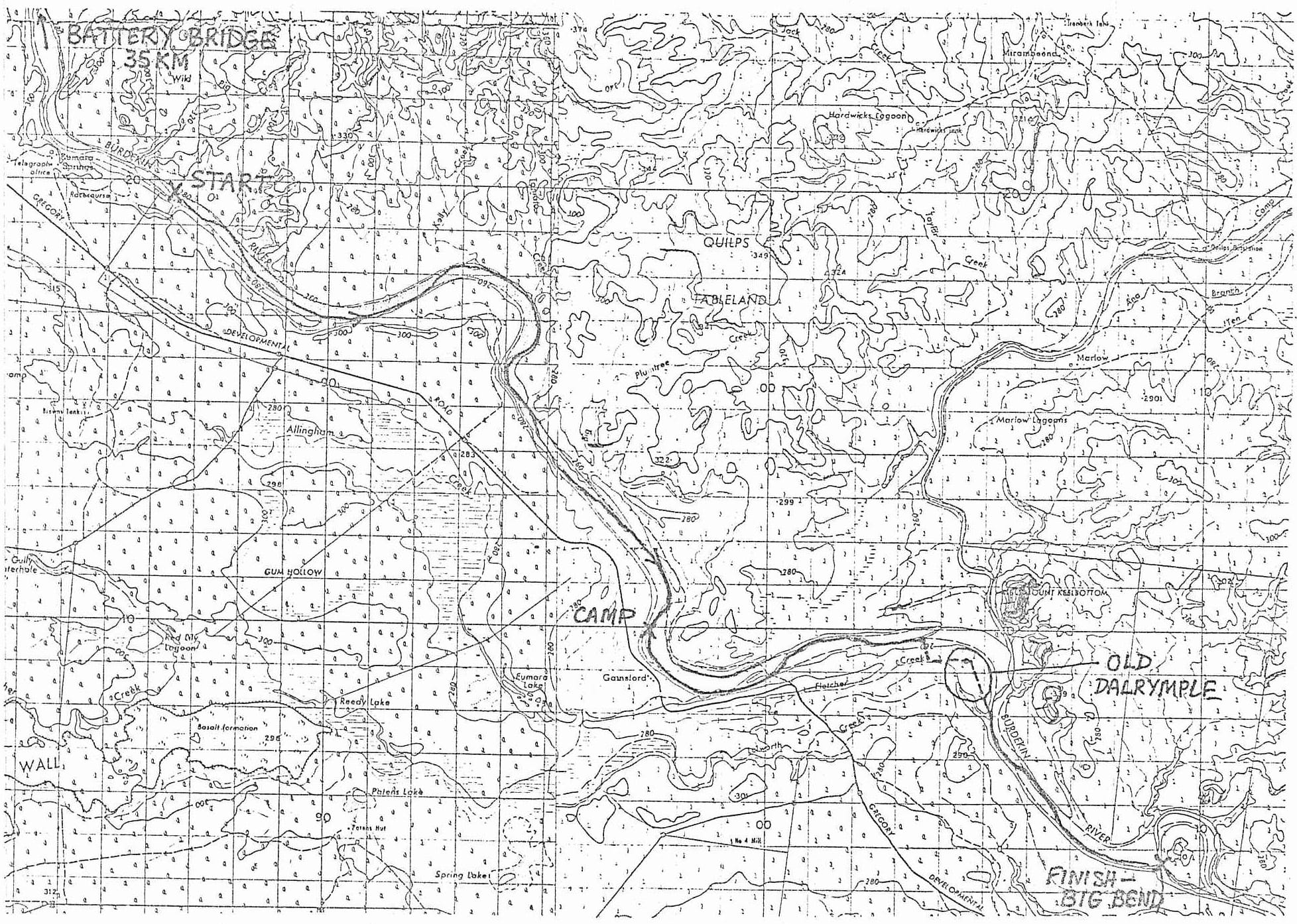
RAFTING DOWN THE BURDEKIN - 6/7 FEBRUARY 1988
One of my colleagues at work, Rick Joyce is a American with a sense of adventure. Two of his ambitions are to cycle up to Shellburne Bay on Cape York Peninsula and to explore the Kimberleys in WA. For the time being, however, work commitments have precluded such expeditions, so he sought a little adventure closer to home by rafting down the Burdekin. His first trip was in the New Year weekend, when Townsville had had over 200mm of rain in a week, and the Burdekin was a raging brownwater torrent. Launching himself from the Battery Bridge, he had a wild, exhilarating ride, covering about 15km in 1 1/2 hours. Then the current bore him directly at a tree, his paddle broke in his desperate attempt to avoid the obstacle, and he hit, losing his supplies. Since he had another 100km to go, he abandoned the expedition and walked out, with further adventures on the way.
Thwarted but determined to try again, he teamed up with me for another attempt. Since the river was much lower, we decided that we could only get from the Battery Bridge to the Big Bend, a river distance of 76km, in the weekend. The river looked very low at the Macrossan Bridge, so we thought that even this distance might not be possible. We arrived at the Big Bend (40km from Charters Towers) at 9am, looked critically at the sluggish stream, and decided to cut the distance in half and raft from Eumara Springs station (see map) to there. Leaving one car there, we drove to Eumara Springs and wasted some time trying vainly to find someone to get permission to leave the other car there. Eventually, we parked just off the Lynd Road a couple of kilometres away, and carried the gear to the river.
On arrival, we waded about, judging the river depth, and decided to 'have a go', even though it was only about knee deep. We inflated the raft and lilo, placed the supplies in the latter, tied the two together, and set off. We paddled slowly along for about a kilometre then - uh-oh - a gentle scrape on the bottom told us we were running out of water. A mad thresing failed to get us to deeper water, so it was out of the raft, and to it along in the shallow stream. The raft floated perfectly well without us in it! This process was to be repeated many times on the trip. There were some obviously permanent lagoons, and we had no trouble with water depth there, but there was very little current in these, and our rate of progress was not very good. You can only paddle at 2-3 km/hr in still water in a raft, especially if you are towing a lilo with supplies. You could make much better progress with canoes, but their draught is probably greater.
About midday, we pulled to the bank for lunch. On trying to get out of the raft up the steep bank, we discovered we had stopped in the deepest lagoon so far, and Rick took a plunge. At least it cooled him off in the 35° heat. After unloading, we had a pleasant dip in the deep pool (second time for Rick).
The afternoon passed slowly, with good stretches of paddling alternating with a lot of towing. We discovered that the deepest and fastest-flowing water was right by the bank on the outside of the bends, and made good progress in stretches. Unfortunately there were also a lot of snags close to the bank, so it was a bit of a slalom exercise. On a few occasions, the we and the supplies lilo went around opposite sides of an obstacle, bringing us to a tangled halt. Once or twice, one of the plastic bags parted company with the lilo and floated off on its own. Unfortunately, the garbage bags were not completely waterproof, as we discovered later.
The heat got to us about 3.30pm and we rested up about an hour and a half. Invigorated by the rest and the cooler air, we continued at 5pm. We were running well behind schedule, only averaging 2km/hr overall, so we decided to paddle on into the evening until we reached at least the halfway point, and preferably Gainsford Station, 20km from the start. It was a pleasant evening with a 3/4 full moon, and we had the best run of the trip, with only one or two delays in nearly 6km. About half a kilometre before Gainsford, we ran into rocky country, and about 10pm, we came upon a couple of small rapids! Negotiating these in the dark didn't seem a good idea, so we called it a day. Then we discovered that a garbag with a couple of insignificant holes quite easily lets in water, which then accumulates in the bottom of the bags, soaking whatever is there. Fortunately, only some of the clothes and gear got wet.
Next day, bright and chirpy (and slightly cooked from the sun the previous day) we portaged around the rapids and launched once more. As before, good stretches alternated with slow, but nearing the site of old Dalrymple township, the going really deteriorated so that we were doing more walking than floating. For variety, and to speed things up, we cut the bend and portaged through the town site. Only some pleasant trees, a few tracks and a couple of graves are left now - the white ants have long since devoured the old wooden buildings. It is however a nice area for a picnic, and there were a couple of parties of day-trippers from Charters Towers. We had lunch at the junction with Fletcher Creek and Rick patched up a slow leak in the raft which was threatening to become a fast one.
After lunch, there remained a 5km reach to the Big Bend, and the going was reasonably good, with some mildly exciting stretches where we whizzed along the bank or "shot the shallows". The sounds of a ghetto-blaster greeted us as we glided in to the Big Bend camping area, but the revellers left shortly after.
From just downstream of Eumara Springs to the Big Bend we had covered 36km, which we had paddled about 30. There was an abundance of wildlife, including wallabies, lizards of all sizes, cockatoos, brolgas and other waterbirds, as well as cattle, horses and goats. Quite an interesting, slightly unusual trip for a weekend.
DOUG SWEET
EASTER BREAKAWAY
Whilst Southeast Queensland experiences the worst flooding since 1974, and the subsequent declaration as a disaster area follows closely on the heels of a similar declaration due to Cyclone Charlie on the mid-north coast, four individuals from the Townsville Bushwalking Club set off to explore the forests of the Mackay region.
A short lead up and a lack of prior knowledge and research caused the only two mishaps of an otherwise most enjoyable Easter in the Mackay area. The misadventures were both navigation errors made by yours truely whilst still seated in his automobile – enough said on that topic.
Friday 1st April - Day 1
Departed Townsville in two cars at 6:15 am arriving at the Rangeview Caravan Park at 12 o'clock approximately. It was necessary to stay in the van park as all the National Park campsites were solidly booked. The six hour trip was prolonged by breakfast north of Bowen and an interesting detour that was supposed to cut out Mackay but we managed to find our way back there anyway.
Having established camp and marvelled at the view, we were off to the ranger station to gather much needed information on our proposed overnighter on Mt. Dalrymple. The ranger was out so we amused ourselves looking at the tourists and eating really terrific cake from the kiosk.
Two o'clock and the ranger returned. Stood in a line whilst he dispensed justice and knowledge to the assembled flock. My turn. Who am I? What do I want? Zoom and into the back office – maps and information sheets at our disposal whilst he continued to smile and deal with the tourists.
One lady reported in very distraught. Seems her ankle-biters had made an astonishing zoological discovery. Glenn volunteered to take it off her hands but she had already doused the kids with kero and not many self-respecting ticks will hang about after such poor handling.
Pity I can't remember his name, but I'd recommend the ranger at Eungella for a promotion. Perhaps the secretary could dash off a letter of thanks courtesy of the TBW.
Returning to our campsite we continued with the final preparations for the walk and deciding to do a car shuffle before dark, set off back down the range. Some 30 minutes later, after a final purchase of "Stingoes" from a shop at Finch Hatton, a car was left as far as possible into Finch Hatton Gorge. (A 4WD would be an advantage here, but a time save of only 20 minutes walking.)
Saturday 2nd April - Day 2
Up with the sun. And what a great sunrise it was from the van park. Breakfast at the ranger station to catch a glimpse of the platypuses, but none to be seen. Apparently there have been none seen since Cyclone Charlie.
Now comes the second geographical embarrassment. Here we are half-way to the Eungella dam and we realize that this is not the way to the start of our walk. So we return to the ranger station, tail between our legs to find out where we have gone wrong. Of course, we know where Mt. Dalrymple Road is. It just hadn't crossed anyone's mind that this was the one we should be on. So back into Eungella and on the right track. (As you reach the top of the range, it's second on the right and keep taking all the rights.)
Thirty minutes later along a reasonable dirt road we came across a National Park sign. It is in the bush behind here that our track begins we think. Well, at least there seems to be a taped trail. I wonder it it's the right one but I keep that to myself.
We were told four hours to Mt. Dalrymple. I smirked at this but in fact it took us seven hours. What follows is the first day's walk:
Departing from the National Park sign on a very well-taped though sometimes vague track at 9:30, found us on a gentle incline rising from 2800m to 3000m. Passed through a depression rich with palms and ferns. Also rich with leeches, our first for the walk. Some 30-40 minutes later found us at a very beautiful creek at about 3200m. I of course immediately set about preparing morning tea. Some 40 minutes later we decided that we had better complete the remaining 8 Km to be covered this day.
Over the next hour and a half to two hours we climbed to 3400m and back down to 3200 to arrive at another creek. Here found four people returning from the peak. They had spent the previous night up there, despite the ranger informing us that no one had been up there for two months. These four informed us that there had been a further four people at the summit who had approached and returned on the Finch Hatton side.
We enjoyed an extremely cold swim and then lunch at this creek. Dallying for about one hour and a half we were hastened on our way as rain began to fall; only a shower thankfully.
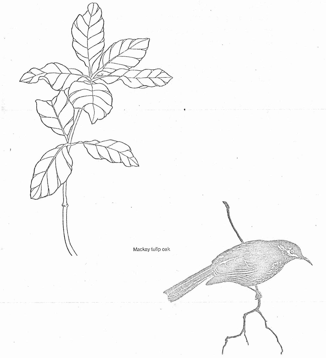
Total distance covered so far approximately 4-5 Km and 5-6 Km to go -- sitting at about 3200m and 800m to climb to reach the peak of 4000m. Vegetation encountered: red cedar, Eungella satin ash, white beech, Mackay tulip oak, piccabeen palm and livistona palm. This combination makes up the complex notophyll vine forest. (Wonderful these Nation Park hand-outs. I would simply call it upland rainforest.)
"Upland" is what we experienced for the remainder of the day. Pausing briefly at a trickle sign posted "Last Water", we pushed for the top, eventually reaching another sign post at approximately 4:30.
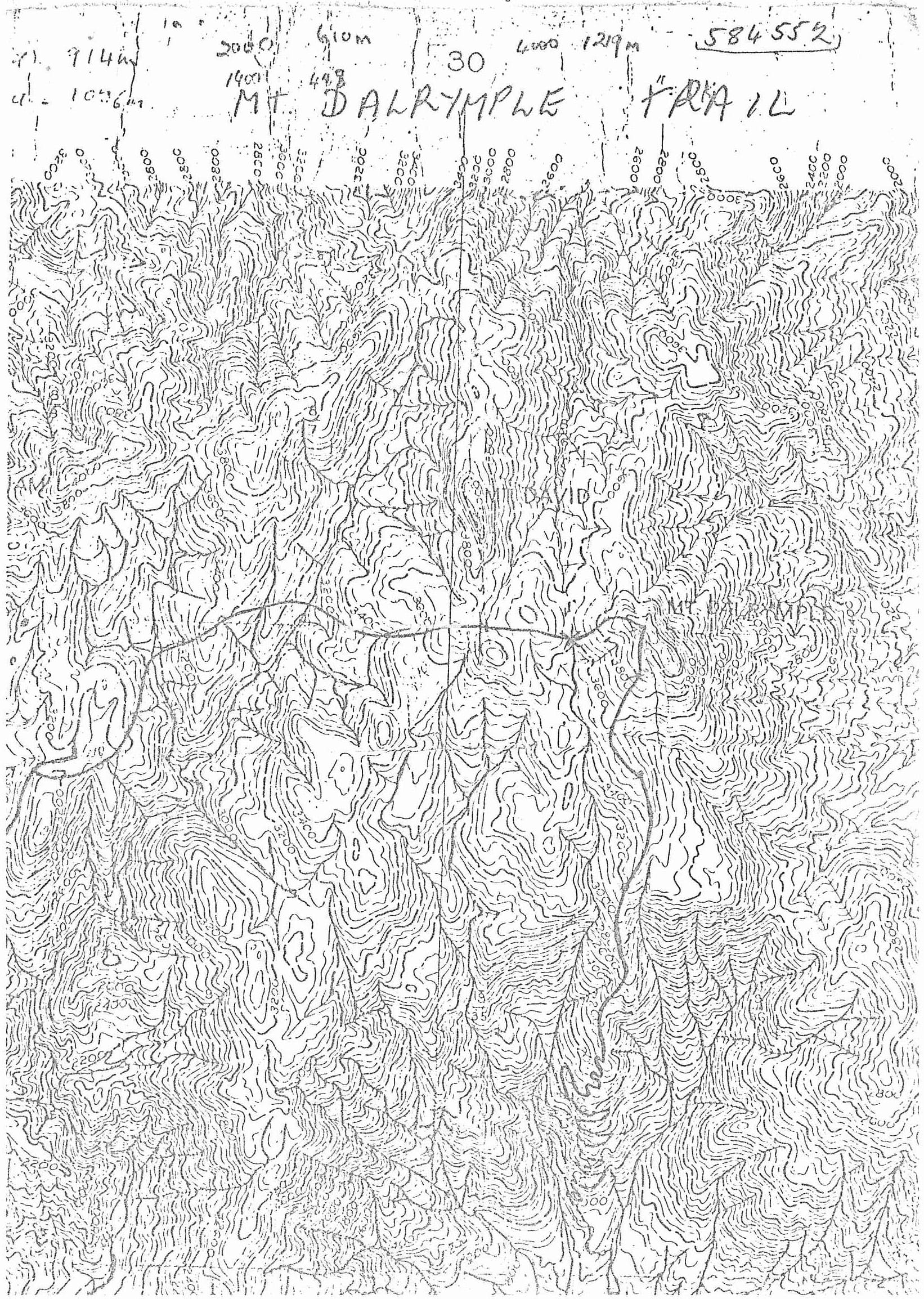
The view from the top really is one of the best that I have seen for quite some time and very much worth the walk. There are views for virtually 360°, uninterrupted, clear to the coast and back to the ranges to the west. Mackay Bushwalkers have placed a plaque on the top pointing out various points of interest. I will not dwell on the merits of the view as Glynis has composed a poem on the subject.
A mere 25m down the track towards Finch Hatton is a large boulder outcrop. It is here that most people spend the night. (A tent would not be necessary for a small party -- 2-3 people -- in fair weather.) On seeing the campsite I wonder how eight people could have found room there on the previous night. I found it crowded with four. As it was, it appears to be sharing the space with some local fauna.
Several large birds were making a great to-do of settling for the night (presumably scrub turkeys) and later in the evening a brush-tailed possum was spotted trying to sneak up on our camp. This necessitated taking the food to bed with us.
Glenn and Glynis want back up to the top to have a look at the view by starlight which gave birth to a poem. Glenn was saying things like "heavenly" which promted M.J. and I to take a stroll up there. Unfortunately we couldn't see a thing. The clouds were all around us bathing us in a very diluted and moist full moon. We went to bed promising to get up there for sunrise.
After being disturbed several times during the night by leeches that had somehow found their way into the tent it came to my attention that there really was quite a nasty storm going on out there. We had a little damp in the $99.00 Korean special (tent).
Sunday 3rd April - Day 3
Everything was a little damp and the weather was not conducent to climbing back up to the top. A bit of a lazy start saw us heading out at around 9:30. Approximately 30 minutes later we passed the "Last Water" sign for those coming up from Finch Hatton.
The easterly side of the mountain is quiet different from the westerly side — much more erosion and far more boulders. It is altogether wetter and leads to a very different kind of rainforest.
We have another 10 Km to go today and we have to drop some 3400m. This combination, despite being all downhill, took us an incredible seven hours.
All I can really say about the walk down was that it was downhill all the way. In retrospect I'm really glad we chose the eastern traverse rather than the western alternative. It would have been a very different walk.
We made two brief stops about two hours apart as we pushed on to make our lunch spot on Dooloomai Falls. This is the highest extent of the graded tracks in Finch Hatton Gorge and would be worth a day walk from the bottom if you were in the area.
After relaxing at Dooloomai, lunching and removing the many leeches that had breached the defences of our gaitors and boots we realised that it was nearly three o'clock and we still had a way to go.
It took us about two hours to cover the remaining distance which was graded all the way. It was in parts overgrown with lawyer cane. The track is old but effective as the country here is pretty steep.
Again, in the National Park brochure, the lowland rainforest of Finch Hatton is classified, this time as complex mesophyll vine forest and contains pink toriga, alexandra palm, red cedar, and terminalia sericarpa.
Near where the car was parked is the picnic and camping area with ample water flowing in the creek. We took a much appreciated dip and headed back for the Eungella caravan park.
All up -- a very enjoyable and rewarding trip.
PETER MORGAN
A NIGHT ON MT DALRYMPLE
G. Lee
A soft, fresh breeze
swept across my face
as I gazed out at the glittering lights.
The full moon lit the surrounding peaks
as the pillow-like clouds
nestled in the valleys below.
Far in the distance
the sky lit up like neon lights -
the evidence of three electrical storms
across the horizon.
The two of us watched in silence
as the flashing jagged beams
soared to the ground.
The scene filled us with elation,
and we watched, transfixed by the beauty
of this magnificent panorama.
We were on top of the world;
Two lone figures on this massive boulder -
Until the mist gradually drifted up the valley,
covering us in a cool, cloud-like haze.
We watched the scene slowly disappear,
until all that could be seen,
was the round haze
of
the
moon.
Townsville Bushwalkers meet every second Wednesday at Vincent State School's Environment Centre, Hodges Cres., Vincent at 7:30 pm. For more information contact Marion or Graham on 71 6803 or Charlie on 75 5204. Our address is P.O. Box 494, Townsville 4810.


