Escape Magazine - December 1987
December 1987 Townsville Bushwalkers ESCAPE: trip reports from Mt Cook (Magnetic Island) and Kents Track, wait-a-while tales, Florence Bay People’s Day protest, yoga for bushwalkers, wildlife spotting tips, snake safety, club news and AGM details. North Queensland hiking magazine.
ESCAPE Townsville Bushwalkers' Magazine
Dec. 12 1987
G'day Bushwalkers,
This is our final newsletter for 1987. Inside you'll find a variety of articles . . . everything from a report on People's Day at Maggie's Florence Bay to Yoga Tips from Glynis. You'll learn some new words thanks to Charlie's Amazing Vocabulary Builder and there are trip write-ups too!! Find yourself a piece of shade and a comfortable rock to lean against . . . relax and enjoy the pages that follow.
Mary Jane
! YOUR EXECUTIVE !
President ............ Dave Whyte
*Vice President ........ Charlie Allen 75 5204 (Home)
*Secretary ........... Mary Jane Henderson 71 8284 (Work)
*Treasurer ........... Alan Watson 79 6659 (Home)
Social Director ...... Marion Gaemers
Newsletter Editor .... Mary Jane Henderson
*For information about club activities, meetings, etc., contact these people.
Our AGM is held in March and at that time our EXEC. ELECTIONS will be held. You might think of taking on a position!!
ANYONE FOR WAIT-A-WHILE?
KENTS TRACK 22-23 AUGUST
The Plan
Leave Townsville early on Saturday morning and breakfast at Cardwell. Leave the vehicles at a quarry at the start of Kents Track. Follow the track up a ridge to Carrons Creek Road and pick up the freshly brushed track to Kennedy Creek Falls. Camp at the creek crossing on Carrons Creek. Sunday, a leisurely stroll down Kents Track back to the vehicles.
The Walk
We left Cardwell at 8:30 am and commenced walking at 9:15. We were to fill our water bottles at a creek crossing on the way, but it was muddied by cattle. Alan found the track easily and we were walking up a steady well-defined ridge. The track had been used for hauling logs and the ridge was covered in open forest. Kennedy Creek was on the south side of the ridge.
The track was well-defined until we were confronted with wait-a-while (W.A.W.). We started sharing water as some of us did not have any. There was no track around the W.A.W. unless we wanted to leave the ridge so, Alan donned his gloves and out came the secatours. Paul conveniently had a pair as well. (I should have brought mine too!) The W.A.W. made progress slow and the ridge kept a steady slope.
We supplemented our water by sucking on lawyer cane cuttings which were sweet and refreshing. We stopped for lunch beneath an overhanging rock which had been partially dug out. There was enough water for a cuppa each. Alan declared that we were 100 metres in altitude below Carrons Creek Road.
On our feet again, the W.A.W. started to thin out but not entirely. We reached the top of the ridge but there was no sign of a forest road. Alan maintained that a westward course would take us to Carrons Creek Road. We continued west and the ridge gave way. We were in rainforest now which prevented the sun from shining in. Conditions were okay, but water was needed as we had been sweating quite heavily.
We descended a little and by mid-afternoon we chanced upon a very small creek which had a small pool of water in it(just enough to fill our water bottles). We rested here for a short while. Keeping a westerly course meant a steep climb up a side of a ridge. (Aha! The track will be at the top of this ridge!) At about 5 pm we reached the top of the ridge and stayed on top of it. Alan spotted some trees that had been blazed a long time ago so we kept heading west and came upon an old bull dozer track. We decided to move fast as daylight was fading rapidly.
But, it was dark by 6:45 and some of us were wishing we were somewhere else. Alan was convinced that the track was not far away. Where we were was not suitable for the night. We turned on our torches and John and Peter took the lead. We lost the bulldozer track and started to descend. The vegetation was not kind but suddenly Paul dropped down onto a road. Well....this made our night!
We were all on the track and to our surprise there were glow worms glowing in the earth bank on the side of the road. As we walked along we could hear Carrons Creek quite clearly and knew our dehydration would soon be over. More and more glow worms appeared on the side of the road. A couple of times we sat down and turned off our torches to observe them. There were hundreds.
At 8:30 we came upon a clearing and the creek crossing. It made a very suitable campsite. There was even some dry tinder left for us. We all turned in at approximately 10:30.
Sunday morning was no rush. My legs were heavily scratched but I was not the only one. We decided to walk out along the Kirima Range Road. This way there wouldn't be any W.A.W.
The walk out was relatively uneventful. We passed the recently brushed track to Kennedy Creek Falls. When we joined the Kirama Range Road we still had about 12 Km and some cross-country to do before getting to the cars, all of it downhill. We had lunch at a waterfall over halfway down. Going cross-country to the cars we unavoidably got our feet wet.
I don't recommend this trip to anyone! A sane person would drive up Kirama Range Road, turn left at Carrons Creek and drive to the campsite. You could camp the night near the cars and for an evening activity I would recommend observing the glow worms. On the following day, take a walk to Kennedy Falls.
And ....... the winner of the lovely legs award.......Barbara!
JIM CAMERON
BITS AND PIECES * BITS AND PIECES * BITS AND PIECES * BITS AND PIECES
PACK FOR SALE
Lowe Travel Pack
Mary Jane 212896
SORRY TO SAY GOOD-BYE
. . to Marg and Ann who
are leaving North Queensland.
We wish you all the best.
INFORMATION
Townsville Bushwalking Club receives monthly newsletters from other clubs and from the Wilderness Society. As well, we receive considerable promotional material from various travel/holiday companies advertising bushwalking tours, etc. I have organized these bits and pieces in a binder which I will bring to meetings. If anyone wants to borrow the material just let me know.
MARY JANE
SPRING CREEK - ST.MARGARET'S CREEK 31 OCT/1 NOV
While the main party of walkers were on the Tully Gorge trip, a small, 'select' group, David Fowden (leader), John Hunter and I set out at 7:00 in the morning for Mt. Elliott National Park. The aim was to follow Spring Creek from Pangola Park until it petered out at a 690m saddle (see point X on the map) below 'The Shoulder' of Mt.Elliott, then drop into St.Margaret's Creek and follow it down to the plain. If we had the time and energy, we would also pop up to the Shoulder, 350m above the saddle at the top of Spring Creek.
We set out from Pangola Park at 8:40 and and made good progress along the west bank of Spring Creek. I admired the beautifully-symmetrical Trinity Palms that are a feature of this side of Mt.Elliott. After half-an-hour, we arrived at the point where Spring Creek turned towards the mountain. The creek was flowing well at this spot, although it was dry further downstream, where it probably flows underground.
As we set out again we regarded the weather dubiously - it was looking rather ominous towards the mountain. Thoughts of doing a U-turn were brushed aside by David, who set out at a sprightly pace, wanting to get as far up the creek as possible before being slowed down by rain-wet rocks. We passed several nice swimming holes but we weren't hot enough to be tempted at this stage. This part of the creek is open and pleasant, and we ascended steadily, getting occasional glimpses of the plain below. About 10am I felt a pitter-patter on my head and saw some splashes in the pools and thought - uh-oh - Sharp Elliott all over again! Fortunately, it stopped after a few minutes, though it remained overcast and windy. This was good, as it made the going cooler.
At 10:30 we made the plunge into one of the pools - not for long, the water wasn't exactly warm. After a scramble up a waterfall we had an early lunch on a broad shelf of rock with a distant view of the plain. There was time for a couple of cups of tea. Our altitude was about 300m. This was as far as we had reached on the previous Spring Creek walk. From now on, it was unknown territory!
For the next kilometre or so, we had to watch the compass carefully, as the creek swung round from west to north, but had several major tributaries going west or northwest, and we didn't want to shoot up one of those. We found a very nice swimming hole at least 2m deep just before the bend, but kept on until we were sure we were heading in the right direction. As it happened, it wasn't that difficult (at this stage) to keep on the right course, as only one or two of the side creeks were of any size. At about 400m we swam the last available hole. From then on, the water flow steadily diminished, the creek narrowed, and wait-a-while put in an appearance. However there were some pleasant spots on this part of the creek, with some miniature "gorge" formations.
At about 500m, the gradient became steeper and the rocks wetter and more mossy. We were well and truly into the rainforest. We were not alone, and came upon wild pigs on both that day and the next. We decided to load up with 3-4 litres of water at the last pool at 580m 'just in case', although we were hoping to make it to water on the other side. (As it turned out, it was lucky we did so). Shortly after, the creek petered out, so we just pushed on upwards by the least-steepest route, trying to find the saddle at 690m. When my altimeter said 700m and we were still picking our way up through wait-a-while and other prickly vines at an angle of 45°, I knew we'd missed the saddle. But which way? East or West? Nothing for it but to continue the climb in a Northerly direction until we ran out of slope. It finally levelled out at 750m (according to the altimeter). We were too far East, but we only had to drop a little way into the saddle - the altimeter was reading about 40m high. From there, we could dimly make out the valleys on either side but the vegetation was too dense to get any real view. The time was about 4:30, so we did not attempt "the dash for the shoulder".
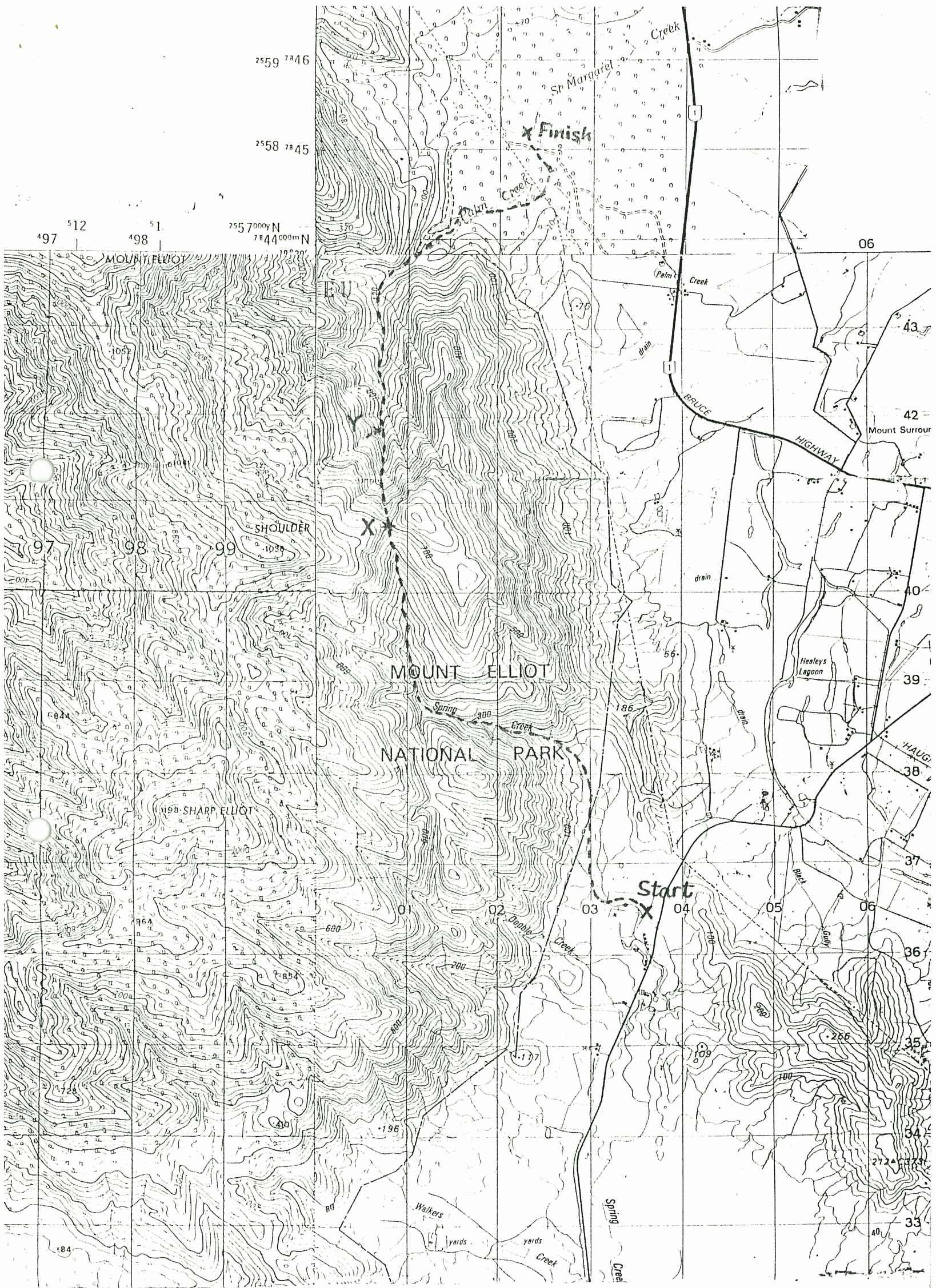
As we set out down the other side, the ground dropped away very steeply. At this stage David was bounding merrily down the slope, while I was feeling a little ragged around the edges, as I hadn't done an overnight walk for several months and was decidedly unfit. John and I slowly picked our way down the slippery slope through and around thickets of wait-a-while and other related vines, "hey-bobbing" every so often to keep in touch with David. About 5:00 pm we found a flat spot about 120m down from the saddle and decided to call it a day, as the light was getting quite dim. It was pleasant to sit back amongst the rainforest giants. As the light failed, the forest came alive with birds, the most interesting being the wompoo pigeon, which makes a sound exactly like its name. There were hummingbirds, flying foxes and all sorts of buzzing insects. Possums kept knocking things from the trees but didn't try for our food.
During the night and early in the morning, there was some light rain, but very little penetrated to the forest floor. We set off at 8:00 am, resuming our plunge down the steep slope. Eventually, we came to the upper reaches of St.Margaret's Creek and the descent slowly flattened out, but progress was slow over large, wet boulders. About 200m down from the campsite we found another pleasant little ferny "gorge" with flat rock on the bottom. As we made our way down St.Margaret's Creek, the going became easier, and we started to find more swimming holes.
We came upon the highlight of the trip at about 10:30 am - a magnificent waterfall flowing into the main creek from the left (see point "Y" on the map). In the lower part, water flows over flat, very steeply inclined rocks, dropping about 50m. Above that there is a very pleasant swimming hole, into which flows a 30m high waterfall, with interesting, dark rock formations. We did not have time to try the swimming hole, but this would be a very good place to go for a day walk. For me, the trip was enlivened near this spot by my first experience of gympie - an innocent-looking little plant 40cm high with only 3 leaves. Fortunately I only had a minor 'brush' with it.
Further down from this waterfall, there was a very large, deep swimming hole. About 2pm we came to the St.Margaret's Creek waterslide, but did not stop there. Shortly after, we passed the other main branch of St.Margaret's Creek and found the track along the east bank. A brisk 45-minute walk brought us back to the car at the St.Margaret's Creek campsite. After a dip back at Pangola Park, we refreshed ourselves in the bar before heading home.
I found this walk very interesting - it covered two of our previous walking areas and some new country in between. Several variations are possible, eg going up to 'The Shoulder', and possibly to Mt.Elliot from there, though that might take more than 2 days; checking out the high point east of the saddle - you may be able to get a view from there; and going up the other branch of St.Margaret's Creek. I'm sure there are many new routes to be explored in other areas of Mt.Elliot National Park as well.
DOUG SWEET
HOW DEADLY?
One advantage of bushwalking in Australia is that we have little to fear from most of our wildlife. There are however a few exceptions to this rule. Events over the last couple of years have reminded us that the estaurine crocodile isn't to fussy about what it eats. Fortunately the type of environment that suits them is not encountered on most of our walks & it's only occasionally that we have to consider their presence.
The other notable exception to this rule is of course snakes. Marg Hayes close encounter with a rather aggressive serpent on the recent Bartle Frere trip, reminds us that wherever we go in this country we have to be alert for their existance. That some of our snakes are quite dangerous is news to nobody, but have you ever wondered just how deadly they are in comparison to some of their overseas relations?
In 1967 a naturalist & guide conducting a bus load of tourists through an area of South East Queensland was bitten by what he believed was a western brown snake. However despite treatment with the appropriate antivenom for this snake, his condition deteriorated quickly. He didn't die, but it took months of intensive medical treatment before he regained some semblance of health. He never fully recovered from that bite.
Subsequent study identified the snake as a species related to the Taipan. Now commonly known as the Western or Inland Taipan, it is probably the worlds deadliest terrestial snake.
The following chart compares the venom toxicity of some of our more dangerous snakes to that of a few of their well known & deadly kin from other countries. The Indian Cobra which I once believed was the worlds deadliest, has been used as a reference.
| SPECIES | RELATIVE TOXICITY |
|---|---|
| Inland Taipan (Oxyuranus microlepidotus) | 49.5 |
| Comm. Brown Snake (Pseudonaja textilis) | 12.35 |
| Taipan (Oxyuranus scutellatus) | 7.87 |
| Comm. Tiger Snake (Notechis scutatus) | 4.25 |
| Comm. Death Adder (Acanthophis antarcticus) | 1.47 |
| Comm. Cobra (Naja naja) | 1 |
| King Cobra (Ophiophagus hannah) | 0.26 |
| Rattle-Snake (Crotalus adamanteus) | 0.06 |
As you can see, present methods of measuring venom toxicity indicate that venom of the Inland Taipan is roughly fifty times as potent as that of the Cobra, or almost eight hundred times as that of the Rattle Snake. These figures have all been derived by determining the lethality of the different venoms on mice. If another animal was used for the tests there would probably be some variation in the results, as all creatures can't be expected to react identically to the different venoms. Never the less the figures can be considered as a pretty good guide to the relative deadliness of the venoms where humans are concerned.
Toxicity isn't the only factor determining the deadliness of determining the deadliness of a snakes bite. The next chart also takes into account the average venom yield of the various snakes & as you can see the relative position on the chart has changed considerably for some species.
| SPECIES | RELATIVE LETHALITY INDEX |
|---|---|
| Inland Taipan | 5.87 |
| Taipan | 4 |
| Cobra | 1 |
| Tiger Snake | 0.99 |
| Death Adder | 0.65 |
| Brown Snake | 0.13 |
| Rattle Snake | 0.12 |
What is probably most interesting about this list is that it shows that so many of our snakes are very deadly by world standards. Deadliness of bite & how dangerous a snake is however are not quite the same thing.
The Queensland Museum, taking into account: venom toxicity, venom yield, fang length, temperament & frequency of bite, has produced a chart suggesting how comparatively dangerous some of our snakes are. The common Taipan obviously scores pretty well on the first two counts & with its large fangs (8-12mm), reputation for aggressivness & record of multiple strikes, it appears on the chart as by far the most dangerous. Some distance further down the scale running a close second & third are the King Brown & Death Adder, with the Tiger & Inland Taipan not far behind. Only Australian snakes were considered in this study so no comparison is possible with the Cobra & Rattle Snake.
Fortunately, the Taipans deadlier cousin from the west is not considered very aggressive, & its probably this & the remote nature of the terrain it inhabits that accounts for the rather ironic fact that there has been no recorded deaths from the bite of what is probably the worlds deadliest terrestrial snake. (And the only two cases of snake bite involving this species, have been to snake fanciers).
CHARLIE
YOGA FOR BUSHWALKERS
Here are a few yoga positions which should help ease those aches and stiff areas which mysteriously follow long days of bushwalking.
GLYNIS
ADHO MUKHA SVANASANA — DOG POSE, HEAD DOWN
This position strengthens the arms and legs and rests the head and heart.
USEFUL PROPS: two bricks and a wall; a low stool.
- Place two bricks against a wall, shoulder width apart. Kneel in front of the bricks 2 or 3 feet away with the knees and the feet a hip width apart. The knees, the feet, and the whole body should be in line.
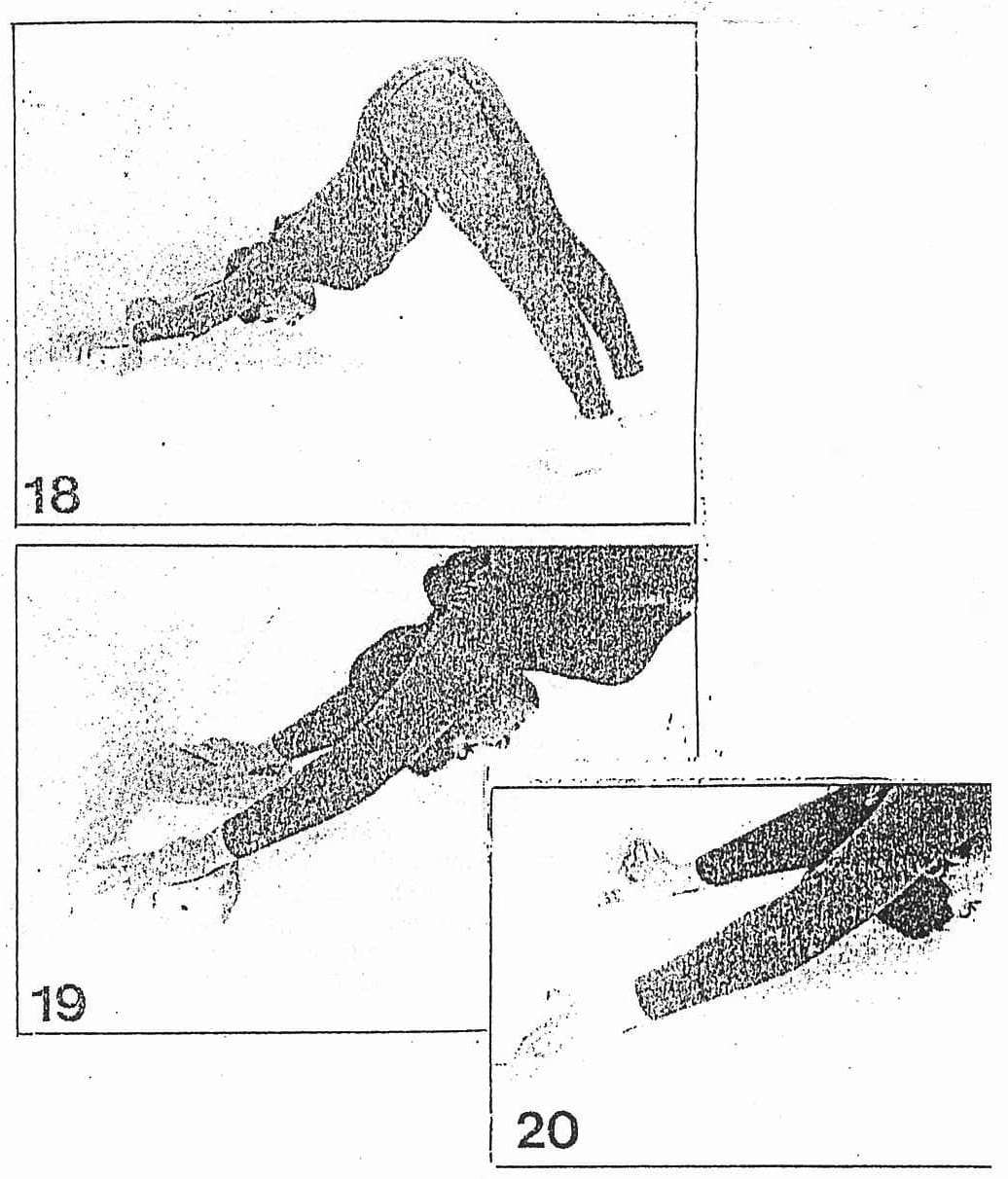
- Place your hands on the bricks, straighten the arms and legs, and bring the toes in so that they are facing forward. Extend the whole body up towards the buttock bones, lifting up the shoulders and making the back concave; point the coccyx and the pubis up towards the ceiling. With a pressure of the hands on the bricks stretch the buttock bones up. Keep the tops of the thighs pulled back away from the hip, and stretch the backs of legs down. Open the backs of the thighs and the calf muscles. In the beginning you may keep the heels up but keep the knees straight (Fig. 18). Gradually try to get your feet to reach the floor. The head and neck should be relaxed but keep the arms strong. Fig. 19 shows a close-up of the lumbar torso with the firm grip of the hands on the bricks helping the arms to pull up and the shoulder blades to work. Stay quietly in the posture with a few breaths, then kneel and come up.
IMPORTANT: To rest the head and the heart or in the case of extreme fatigue, rest the forehead on a block or low stool.
B. (with wall only)
- Do the same posture as before, but without using the bricks. Follow the same procedure, but place the palms on the floor with the fingers against the wall to stop you from sliding and also to help get a firmer grip of the hands, which is necessary to control the arms (Fig. 20). Compare close-up of 19 and 20; in the latter the head is further down and the shoulderblades are working harder. Come up when you feel you have worked well.
C. (without props)
- Lie on the floor, on the abdomen, with the legs and toes stretched back and the arms extending backwards by the side of the body with the palms facing up. Make sure the hips are even and the whole body is lined up. Keep the head slightly up and take a few breaths.
- Take the legs a foot apart and bring the toes in. Bend the elbows up and slide the hands through to the front so that the palms rest by the side of the lower ribs pointing forwards. Keep the distance between the toes and the hands as the base of the posture; i.e. from now on do not move your hands or toes backwards or forwards.
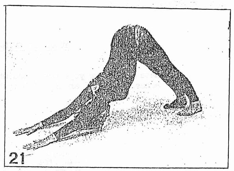
- With an in breath press the toes and palms into the floor, lift up the trunk and kneel. Then straighten the legs and the arms, lift the trunk, and stretch the heels down. Press the shoulderblades into the back ribs and take the head down (Fig. 21). In this variation there is a more complete extension of the whole body. When you are ready, come up.
Adho Mukha Śvānāsana
Adho Mukha means having the face downwards. Śvāna means a dog. The pose resembles a dog stretching itself with head and forelegs down and the hind legs up, hence the name.
Effects
When one is exhausted, a longer stay in this pose removes fatigue and brings back the lost energy. The pose is especially good for runners who get tired after a hard race. Sprinters will develop speed and lightness in the legs. The pose relieves pain and stiffness in the heels and helps to soften calcaneal spurs. It strengthens the ankles and makes the legs shapely. The practice of this āsana helps to eradicate stiffness in the region of the shoulder blades, and arthritis of the shoulder joints is relieved. The abdominal muscles are drawn towards the spine and strengthened. As the diaphragm is lifted to the chest cavity the rate of the heart beat is slowed down. This is an exhilarating pose.
Those who are afraid to do Śīrṣāsana (Headstand) can conveniently practise this position. As the trunk is lowered in this āsana it is fully stretched and healthy blood is brought to this region without any strain on the heart. It rejuvenates the brain cells and invigorates the brain by relieving fatigue.
Persons suffering from high blood pressure can do this pose.
URDHVA PRASARITA PADASANA - III
SUPPORTED UPWARD LEG STRETCH
This is a very restful pose. The inversion of the legs is a partial substitute for upside-down postures.
USEFUL PROPS: A wall and a blanket.
- Lie near the wall with the legs stretched up. You may use a folded blanket under the head as usually the state of the upper dorsal is such that the head drops slightly backward if it is not supported. Line yourself up carefully so that the legs, the trunk and the head are in one line, with both buttocks lying evenly on the floor. Breathe normally.
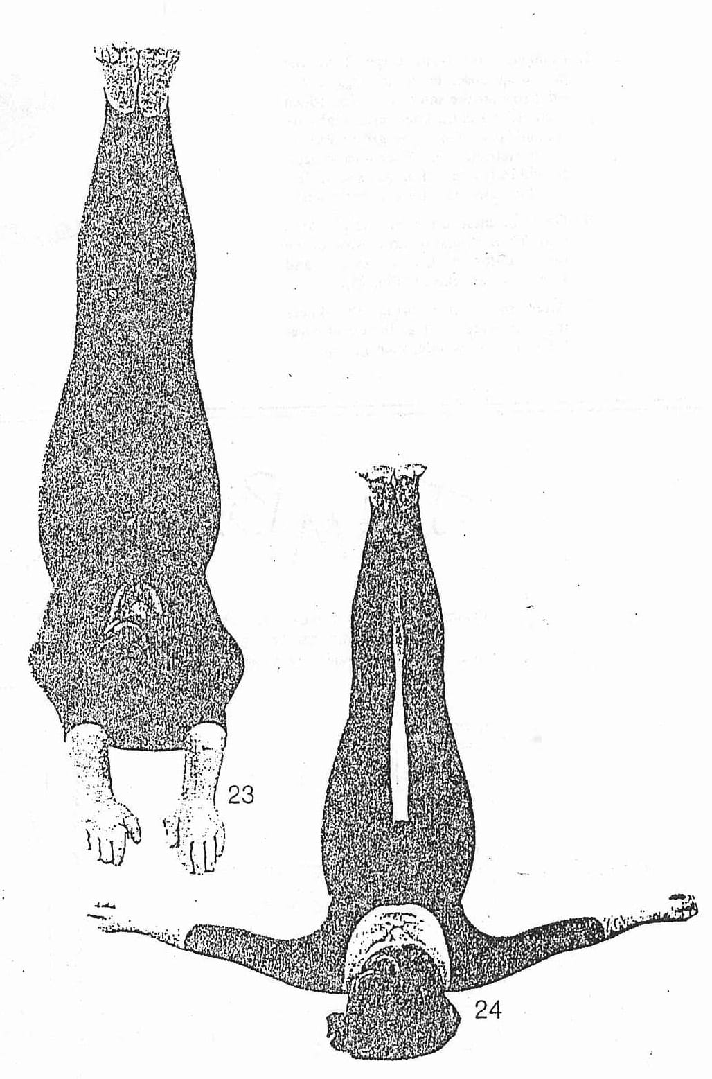
- Press the hips down so that they stay in position and move the waist and ribcage away so that the whole body lengthens. Keeping the whole abdominal area and the diaphragm, soft, with a deep inhalation extend both arms evenly over the head, then exhale and return to normal breathing (which will, however, be slightly deeper than normal). The elbows should be kept straight, the palms open and the fingers extended. Extend the legs up the wall with the knee caps drawn in and the inner heels pressed upwards. With the back of the heels pressed against the wall, stretch the soles of the feet and the toes (Fig. 23). Continue breathing.
- Then with an exhalation bring the arms down and let them rest, with the palms facing up, slightly away from the trunk (Fig. 24). Stay for a while, not forgetting to breathe! You may now proceed to the next posture, or
- Bend the legs, turn carefully to the side and come up.
SUPTA BADDHAKONASANA - COBBLER POSE (LYING DOWN)
This posture is beneficial for urinary disorders, as well as in menstruation and pregnancy. It is extremely restful and healing for the entire lower abdominal and perineal area.
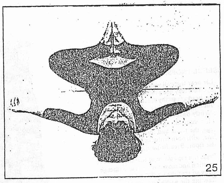
- Following on from stage 3 of the preceding pose, bend the legs to the sides so that the soles of the feet touch each other and the knees and thighs are spread apart. Open the groins but do not overstrain them. The toes and heels should be in line and the soles of the feet should stretch from the toes to the heels.
- Open the chest so that you can breathe well. There should be no tension in the lower abdomen. Breathe evenly and keep the eyes relaxed (Fig. 25).
- After some time bring the knees together, keep the legs bent and care-fully turn to the side, then get up.
JUMBLE PUZZLE

SPOTTING WILDLIFE IN THE BUSH
Those of us who have taken the time to look around the bush when we are on a bushwalk realize what a beautiful and interesting place the bush really is.
Unfortunately, most of our native mammals and a lot of our reptiles and amphibians are nocturnal and it's pretty hard to find their daytime roosts. The best way to see possums etc. is by spotlighting at night either with a torch or a proper spotlight, although its 12-volt battery system may put some people off taking it on 2-3 day hikes. We saw some fish-eating bats (Myotis adversus) foraging over a pool near our camp on Bluegum Creek using a torch. It was incredible to see them come in low and rake their feet across the water's surface, picking up the aquatic insects – water skaters etc. – and or small fish that make up their diet.
Because some people feel more like collapsing or drinking port after a hard day's walk rather than donning their spotlighting gear and heading off into the scrub at night, they might prefer to look for wildlife during the day. The most obvious animal here are, of course, birds, although you might be lucky enough to see the odd snake.
I think the best way to see birds is to sit quietly in a spot where you can hear them, preferably near a flowering or fruiting tree. The best time of day is dawn or dusk as this is when they are active. They wake you up at dawn with their good morning choir. (If you miss this dawn session, it may have something to do with the port you drank the night before.)
Bird calls are very helpful in identifying and tracking down a bird. The trick is to be very quiet and move slowly or they may stop calling and/or fly off. Many birdwatchers try to "whistle up" birds by imitating their call. This seems to work best with smaller birds although I've never been able to do it.
A "whoop-whoop-whoop-whoop" call, usually in the early morning and evening means there is a pheasant coucal, or swamp pheasant, around. He is not hard to identify --about 2 feet long with a long, pheasant-like tail, he spends a lot of time on the ground or in low trees as he is a pretty hopeless flier. They are mottled light with dark brown during the winter but in spring they develop a rich black head and breast but retain their brown wings. Coucals are not related to pheasants. They are in fact, cuckoos (as in the German cuckoo-clock), but unlike most of their relatives, they do not live in grandfather clocks, nor do they lay their eggs in other bird's nests, but build their own nests and rear their own young. Coucals are usually found around creeks and swamps, so you'll probably see or hear one on your next swimming hole crawl.
You might, if you're lucky, be kept awake at night by the continuous calling of another large cuckoo, the koel. The familiar "coo-ee" or "coo-woop" is often heard in the mornings, evenings and at night, sometimes for long, sleepless periods. Slightly smaller than the coucal, and a much better flier, they are about 1½ feet long. The male is glossy blue-black and the female is tan with darker brown bars and spots. Unfortunately, this bird is more often heard than seen as it very secretive. They, unlike the coucal, are brood parasites, laying an egg in the nest of large honeyeaters, pee-wees and figbirds etc. They do not roost in German clocks.
The young koel is usually larger than the host's chicks and promptly pushes them, and any unhatched eggs, out of the nest. Around Brisbane, koels are called stormbirds -- if you hear one calling in the late afternoon, it is nearly always followed by a storm. This rule doesn't seem to apply in Townsville as I've heard one nearly everyday since I've been here and have only seen one storm. Like most cuckoos, koels are migratory birds, flying into Australia and occasionally to New Zealand from South East Asia every spring and returning in Autumn after collecting their now fully-fledged young from their foster parents.
The calls of these two birds are quite distinct from the usual chirps, tweets, and twitters of the Dawn Chorus. These chirps, tweets, and twitters are made mostly by a myriad of Little Brown Birds (L.B.B.), flittering around flowering trees and shrubs looking for insects, nectar, mates, and whatever. As a rule, one L.B.B. looks pretty much like any other but if you look closely, you may be lucky enough to catch a flash of a brilliant red zitting between bottlebrush flowers. This would be the Scarlet Honeyeater. The male only, has this red head, throat, and back, beautifully camouflaged amongst the bottlebrush flowers you find along creeks in drier country. The female, as is usually the case, is dull and boring.**
These are three of the more easily identifiable birds you will see or hear near creeks in dry county. If you get keen and want to identify some L.B.B.'s, you'll need binoculars, a field guidebook, insomnia, and a sympathetic group of fellow bushwalkers.
GLENN BELLIS
** The Editor would like to remind readers that this article refers to the feather species only.
PEOPLE'S DAY AT FLORENCE BAY
The scene at Florence Bay on Sunday (1st November) was one of people frolicking in surf (yes, surf), picnicking under the shade of casuarinas, playing beach volleyball and cricket, and flying kites. All the ingredients of a successful people's protest against the proposed resort development of this, the last of Maggie's unpopulated, easily accessible bays.
There was no need for political rallying, banner waving or slogan chanting. The presence of more that 150 people enjoying all of Florence's attributes, and the useful pens and pencils of the Bulletin's reporting team, ensured that potential developers and, more significantly, the Townsville City Council and the Queensland Government received the message that Townsville and Magnetic Island residents want Florence Bay left as their playground and peaceful retreat.
CAROLYN
MT. COOK
Mt. Cook is the highest point on Magnetic Island. Whenever I mentioned walking up to the top to other bushwalkers, I always seemed to be met with a lack of enthusiasm except from Charlie. Everyone else asked, "What do you want to go there for? There're no creeks to swim in and it's hot and dry". I think the fantastic views as you climb up the ridge and the lovely, small secluded beaches more than compensate for the lack of creeks.
Charlie and I caught the first ferry which went to Picnic Bay. We then had to walk to Nelly Bay as there're no buses this early. (You could catch a taxi though.) By the time we reached the general store for a final cool drink, we were already a lather of sweat and covered in scratches after taking a "short cut" through a creek which was overgrown with bushes which had sharp prickles on them.
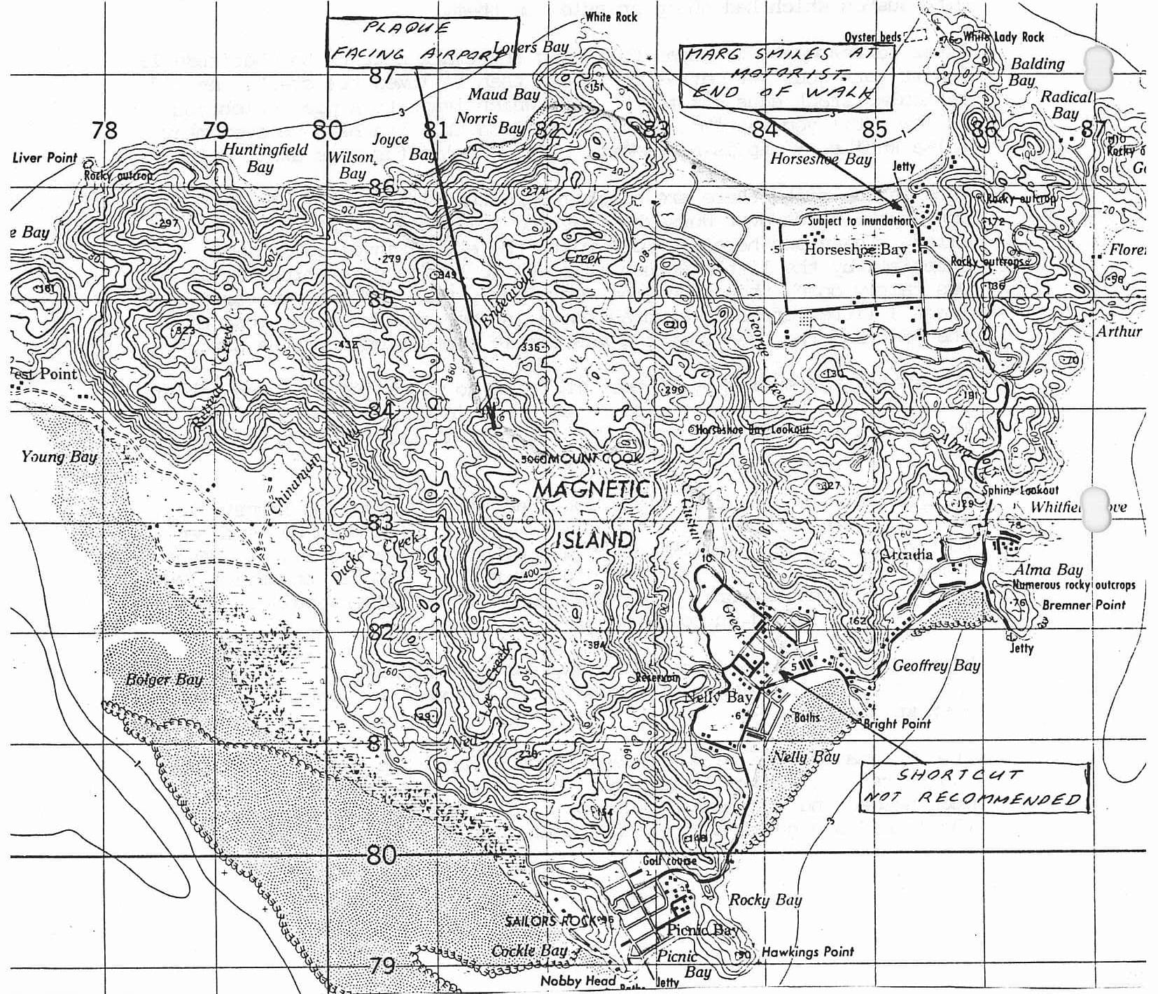
After refreshments we began following the track next to the Latitude 19 Resort for about 300 metres or so and then followed the creek. An old vehicular track goes off to the left which leads to a pipe which you follow until you see "Mt. Cook" painted on it. You head up over many false knolls. A map is necessary. (See Charlie for more exact details.)
Once on the ridge there are several opportunities to climb large boulders for superb views over Horseshoe Bay and Nelly Bay. You can see for miles. The views here are well worth the effort involved. I was surprised by the little amount of scrub we had to bash through. It was fairly open, though very hot work going up. You need to carry at least 3 litres of water each as there is none available for most of the year and the open forest gives little protection from the sun.
We were on the summit by 11 am. There is no view, just a survey point and a plastic tube to put a piece of paper in with you name on it. It's quite interesting to read them all and it seems most people who've been to the top are foreigners.
We then followed the ridge (the long one you can see from Townsville). After scouting around a bit, Charlie found the plaque which is a memorial to two Townsville Bushwalkers who disappeared while paddling to Magnetic Island in 1962. It is located on a big rock, on top of the ridge looking out towards the airport. The views here are really extensive -- all over Townsville and surrounding areas.
We had lunch in a nice shady, breezy spot on the ridge. It was quite a hot day and I wouldn't recommend doing the walk any later than October, when we did it.
From the main ridge we descended to Joyce Bay. The descent took about two hours. It was wonderful just to jump into the ocean. It was a much needed and very refreshing swim. The beaches over this side of the island are quite remote and appear to be seldom visited.
We then followed the coast around to Norris Bay. There were several rocky headlands to go around and over. We then left the coast to cut through a saddle to reach Horseshoe Bay.
Unfortunately, we missed the last bus back, but we managed to hitch a lift back to Picnic Bay.
This is an excellent walk, well worth the effort in the cooler months. After the wet there may even be water in the creeks. I think this walk should be included in the club's list as it is totally different terrain to most other walks. Using taxis would overcome the problem of the busses.
MARG HAYES
Here's some interesting reading. Our Club Historian and Archive Keeper (Charlie) came across this newspaper clipping from twenty-five years ago.
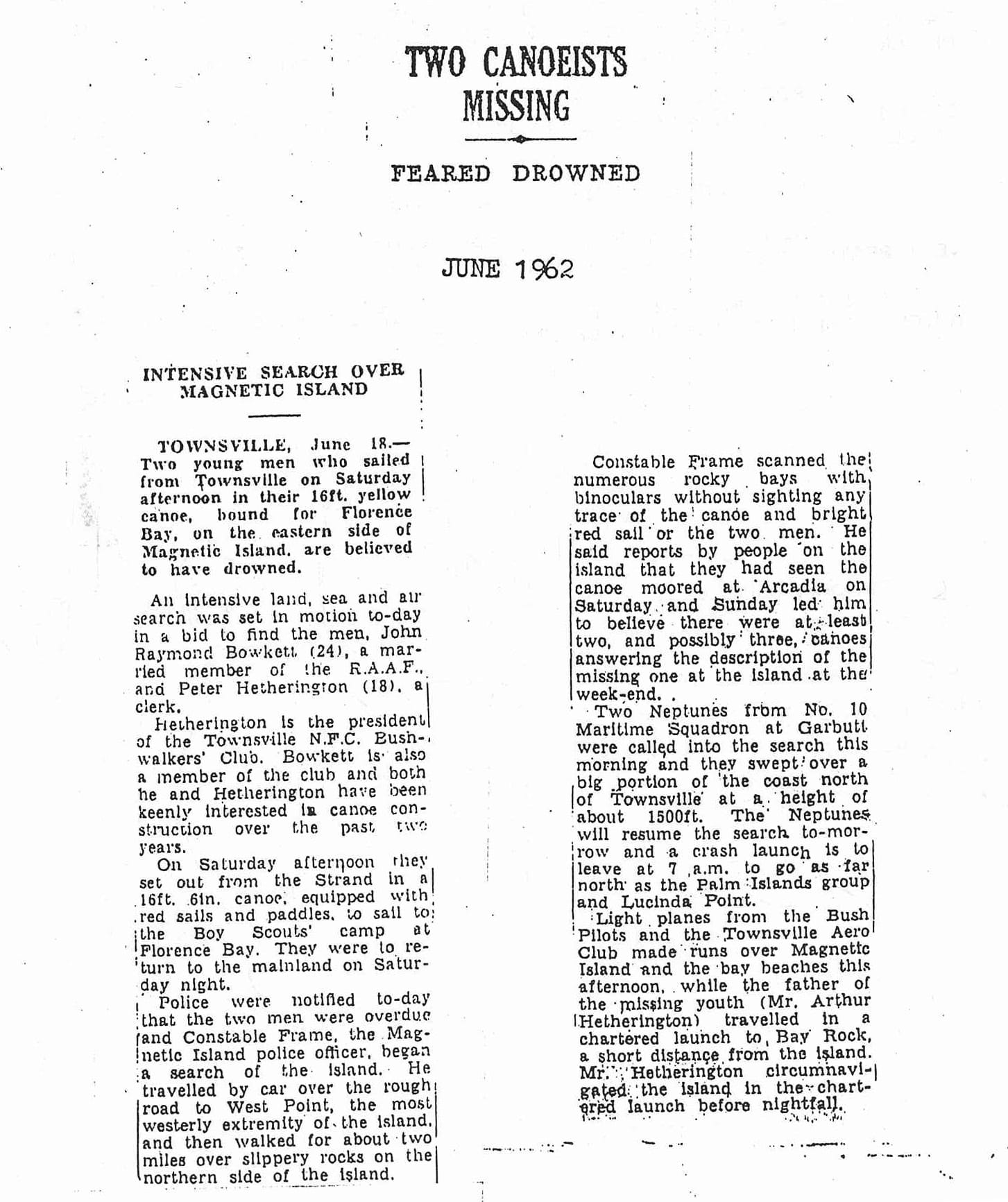
TWO CANOEISTS MISSING
FEARED DROWNED
JUNE 1962
INTENSIVE SEARCH OVER MAGNETIC ISLAND
| TOWNSVILLE, June 18.— Two young men who sailed from Townsville on Saturday afternoon in their 16ft. yellow canoe, bound for Florence Bay, on the eastern side of Magnetic Island, are believed to have drowned. An intensive land, sea and air search was set in motion to-day in a bid to find the men, John Raymond Bowkett (24), a married member of the R.A.A.F., and Peter Hetherington (18), a clerk. Hetherington is the president of the Townsville N.F.C. Bushwalkers' Club. Bowkett is also a member of the club and both he and Hetherington have been keenly interested in canoe construction over the past two years. On Saturday afternoon they set out from the Strand in a 16ft. 6in. canoe, equipped with red sails and paddles, to sail to the Boy Scouts' camp at Florence Bay. They were to return to the mainland on Saturday night. Police were notified to-day that the two men were overdue and Constable Frame, the Magnetic Island police officer, began a search of the island. He travelled by car over the rough road to West Point, the most westerly extremity of the island, and then walked for about two miles over slippery rocks on the northern side of the island. |
Constable Frame scanned the numerous rocky bays with binoculars without sighting any trace of the canoe and bright red sail or the two men. He said reports by people on the island that they had seen the canoe moored at Arcadia on Saturday and Sunday led him to believe there were at least two, and possibly three, canoes answering the description of the missing one at the island at the week-end. Two Neptunes from No. 10 Maritime Squadron at Garbutt were called into the search this morning and they swept over a big portion of the coast north of Townsville at a height of about 1500ft. The Neptunes will resume the search to-morrow and a crash launch is to leave at 7 a.m. to go as far north as the Palm Islands group and Lucinda Point. Light planes from the Bush Pilots and the Townsville Aero Club made runs over Magnetic Island and the bay beaches this afternoon, while the father of the missing youth (Mr. Arthur Hetherington) travelled in a chartered launch to Bay Rock, a short distance from the island. Mr. Hetherington circumnavigated the island in the chartered launch before nightfall. |
SIMPLE ENGLISH?
A QUESTION THAT HAS COME UP IN CONVERSATION A FEW TIMES RECENTLY & HASN'T BEEN ANSWERED VERY CONVINCINGLY IS : WHAT CHARACTERISTICS IDENTIFY AN ANIMAL AS A PRIMATE ? THE FOLLOWING EXTRACT FROM A SCIENTIFIC DICTIONARY MAY HELP ANSWER THE QUESTION.
PRIMATES: AN ORDER OF MAMMALS. DENTITION COMPLETE, BUT UNSPECIALISED; BRAIN, ESPECIALLY THE NEOPALLIUM, LARGE & COMPLEX; PENTADACTYL; EYES WELL DEVELOPED & DIRECTED FOWARDS, THE ORBIT BEING CLOSED BEHIND BY THE UNION OF THE FRONTAL & JUGAL BONES; BASICALLY ARBOREAL ANIMALS; UTERUS A SINGLE CHAMBER; FEW YOUNG PRODUCED, PARENTAL CARE LASTING A LONG TIME AFTER BIRTH.
NEOPALLIUM: IN MAMMALS, THAT PART OF THE CEREBRUM OCCUPIED WITH IMPRESSIONS FROM SENSES OTHER THAN THE SENSE OF SMELL.
PENTADACTYL: HAVING FIVE DIGITS.
JUGAL: A PAIRED MEMBRANE BONE OF THE ZYGOMA OF THE VERTEBRATE SKULL, LYING BETWEEN THE SQUAMOSAL & THE MAXILLA.
I DIDN'T MAKE THAT LAST ONE UP. IF IT MEANS SOMETHING TO ANYONE FEEL FREE TO AIR YOUR KNOWLEDGE.
CHARLIE.
Of all the dangerous Australian snakes, the Taipan is the most intelligent, alert & nervous.
(Mirtschin/Davis)
THE WORST EVER...
It all started from money, or, to be exact, a lack of it. I was cycling, and climbing, across Central Europe. Five years before we had been at war, and the money market was still in chaos - so much so, that no one could take out of England, in one years time, more than £50 in travellers cheques and £5 in cash. By skimping and starving, I was able to travel for 7 months through France, Switzerland and Italy. Besides which, Switzerland had an awful knock-back for me - the monetary exchange rate was 5 to 1 against me - ergo, for every £5 I spent, I only received £1's worth of food - so it was too expensive to eat in that wonderful country. I had a long-term yen to climb the Swiss, or Hornli Ridge of the Matterhorn, so, resolved to buy food in Italy, (21 to 20 ratio here), then transport it over one of the high passes to the foot of the Hornli.
It is an accepted fact that days of travel "when life goes along like a song" tend to become a dim, rosy mist of remembrance - the days that are dominated by trouble and strife are much clearer in retrospect, and, it is one such day, that, until I am no more, is deeply etched into my memory.
I had spent a grand month around the Mont Blac Massif - and got really fit in so doing - then pushed my heavily-laden bike for 28 miles to the summit of the Grand St. Bernard Pass - over 8,000ft. (no big dogs with brandy barrels, now), to be rewarded with a lovely swinging free-wheel of 43 miles down the hairpin bends of Mussolini Road to the Val el'Aosta. A ride down the valley, and another steep push brought me to the village of Brevil, over 6,000ft., with the rather ugly, lumpish Matterhorn away to the north. I camped high above the township, buried my bike in some split rocks, and began to operate my plan.
Sunday was a beautiful, clear, crisp day, and, with a rucksack filled with tinned food, I pushed over the rocky top of the Breviljock, about 10,000ft., to descend onto a long, hard snowfield - no trouble, with heavily-nailed boots and ice-axe. A frozen ridge led me across an ice slope and below some 100ft. seracs (towers of ice that totter and fall from the lower edges of hanging glaciers) to a traverse of the massive East Face of the Matterhorn. It was rough in the bergschrund (the V - shaped crevasse between rock-face and glacier), so I "airy-fairy" walked the icy crest, soon to connect me with a tributary ridge of the Hornli. At about 11,000ft. this broadened out to a small glacier, and I dutifully hid my load of tins in some broken rocks, then back to camp, very well pleased with my 18 miles of to and fro walking.
Monday morn, coming light at 4a.m. - a misty, steamy morning and I light-heartedly packed my camping gear, quite ignorant of the warm "Föhn" wind, that was to cause me a day of dire peril. No trouble, climbing to the top of the Breviljoch, but, immediately I set foot on the snow, I fell flat on my back, whirling and tobogganing towards the open crevasses, 2,000ft. below. I gained momentum at an alarming rate then crash! - an awful shoulder pain, a short, vertical drop, and, completely winded, I flopped into soft snow. I regained my panting breath, to find myself in a crescent shaped caven, that snow and wind had made below the protruding rock. In my battered condition, it took me somtime to realise how lucky I was. This was the only rock on the whole slope - had I been only a few inches right or left, and nothing would have saved me. More luck - I had worn my wrist-strap and so retained my ice-axe - and that instrument is the talisman of safety in that high country. My rucksack had caught the brunt of my bash on the rock and a strap was broken. I tied it up, and started back up the snow, kicking steps up the groove I had made in the slush - a long way, for I counted a least 100 steps before I gained the safety of the rocks again.
I walked gingerly across the field of slushy snow, and followed the ridge. On chancy snow, one dips the shaft point of the ice-axe until it jams - it is then safe to proceed. On the crest, the axe went straight through, and again several times to right and left. Stark terror rose in me - I was standing above a thin ice ridge with the axe perforations around me one step forward or sideways, and I should plunge into an icy grave. So, very slowly and carefully, I backed down the way I had come. I had now to cross an ice slope, requiring some ice chipping and a delicate balance. I was half way across, when, far above, I heard a crack and beheld a large rock, the size of a small house, gathering momentum down the icy incline. I thankfully realised I was just short of its flight path, and watched, fascinated. With a great whoosh it struck a drift to send fountains of soft snow into the air. Ploughing through, it came again onto ice and plummetted on its headlong rush. Chastening thought, had I been one minute earlier, I would have gone down with it. I was dismayed to find, that, since yesterday, many of the sevacs had fallen, and I had to stumble over huge chunks of ice debris. The classic way of passing below the tottering sevacs is to hurry, shortening the time of exposure, but, after my traumatic fall, the sickness, pain and bruises only allowed me a dangerously slow passage.
I was now crossing the foot of the Matterhorn's East Face - 3,000ft. of almost vertical rock, whilst on my right, a long snow-slope fell 2,000ft. to a gaping crevassed galcier. At first I couldn't trust the snow ridge, but, in my weary state, it was too difficult clambering over the lumpy ice in the bergschund, and I ventured once more on the crest, a very long and labourious balancing act, before I staggered, with immense thankfulness, on to the rocky subsidiary spur. I HAD DONE IT - I WAS ON SAFE GROUND AGAIN. I swung my rucksack on to a small ledge, extracted a peach, but, before I could bite it, there was a roaring sound, like an express train, behind me.
The snow ridge, I had been standing on, only ONE MINUTE before, was completely obliterated by an enormous snow and rock avalanche from the mighty Matterhorn, which sped on its way, to be swallowd by the hungry jaws of the crevasses, far below. In my upset, weakened condition it was too much. My terror, at its proximity, stood my hair on end, and my legs turned to jelly. I sank to my knees, and vowed I would never cross the breviljock again - I know I could never expect such amazing luck to attend me as on this terrible day - for surely my guardian angel had been with me! All this before being engulfed by a great thankfulness that I was still alive - for, if only ONE of the dangers had caught up with me, perhaps, many years later, someone would wonder at finding the remains of a very rusty bicycle in the rocks above Brevil. (The peach, quite uneatable, was a soppy mess in my clenched fist.)
A fortnight later, I did make it back, entailing a 24 mile slog over the Gandegg Glacier and the Théodule Pass, but THAT is a not-so-exciting tale of a wandering innocent passing through the glorious Alps.
HARRY KERSHAW
Answers to Jumble Puzzle: billy, Forest, orchid, mountain, bushed


