Escape Magazine - July 1986
The July 1986 Townsville Bushwalkers ESCAPE Magazine marks a revival of the club newsletter, sharing walking stories, Cape Upstart adventures, updates on meeting venues, and a forward program of hikes including Bishops Peak, Tully Gorge, Bartle Frere, and more.
ESCAPE
Townsville Bushwalkers Magazine
July 1986
Editor's Note:
Well, we're back at long last. The bushwalking magazine has been rescued from extinction, thanks to a few avid supporters. I'd like to thank all those who contributed in the making of this magazine and hope that those of you who enjoy reading it or have suggestions for improvement will give some positive support in the form of contributions to the next edition. All help is greatly needed and appreciated. We particularly need some artistic contributions. Remember, if we all put in a little effort - a campfire recipe, a poem, a joke or quote - this eases the burden on others.
This year has seen the departure of some of our regular members and the arrival of some new members. We hope to see Jan, Peter, Larry and Judy back again in the near future. As I have been away for most of the year, I can't give a personal account of the year's walking so far. However, I believe that despite many "wet" walks, there have been lots of enjoyable times as usual. I look forward to the rest of the year's programme.
Editorial Panel: Bea Duffield, Roz Glazebrook and Glynis Lee.
Forward Programme:
Aug 3 Bishops Peak
Aug 16-17 Blue Gum Creek
Aug 31 Palm Creek
Sept 13-14 Tully Gorge
Sept 28 Little Crystal Creek
Oct 11-12 Bartle Frere
Oct 26 Waterfall Creek
Nov 8-9 Mt Spec
Nov 23 Crystal Creek
Dec 6-7 Five Mile
Dec 13-14 Picnic
President's Report:
Thanks to Glynis for editing this newsletter. It is welcomed and any support given to this newsletter by contributors is also acknowledged. Since becoming President, I have been approached by members with ideas and activities. I appreciate this and I will canvass them.
Venues for meetings. The subject that has occupied my thoughts and a source of frustration. The current venue - Aitkenvale Scout Hall. A number of members have expressed verbal opinions on the lack of suitability of this venue. The main objection is having meetings at 8.30pm which is too late in the evening. Other reasons are: gives new members the impression of an association with the Boy Scouts; the hall itself is not practical for our purposes; and the location. On the positive side, it is inexpensive and very informal???
What do we want? How much are we prepared to pay for rent for another venue? Do we want to meet in the city? Do we want to re-structure our meetings and make them more social with tea and coffee with slides or a feature to complement the evening after general business?
Alternatives There are not other venues available that are as cheap as the Scout Hall. There are possible venues available that would cost $8 - $10 per meeting, that is, small church halls and maybe the Arts Centre in the city.
If we are to take on such a venue, how are we to fund it? Collect an admission fee to cover costs? Use club funds and increase annual subscriptions to cover costs?
We could use a member's household to conduct meetings. This could be imposing on their property and forcing them into a commitment that may prove to be unsatisfactory later on eg., holidays or guests.
I am very receptive to any other alternatives any member may put forward, and the general consensus is to find another venue for club meetings.
Members have expressed a desire for more social gatherings. I agree. Should we have barbeques etc after day trips? Dinner and theatre nights? The problem is that a lot of the social activities happen at short notice and are not announced at meetings.
Another suggestion is that we have a navigation exercise for the benefit of members or new members who wish to learn how to find their way around this wilderness (and we are not going to the Basalt Wall to learn).
Jim Cameron.
CAPE UPSTART - A walk or a sedate wander along the beach?
The title says it all. If there's a fine line between the two, we trod it.
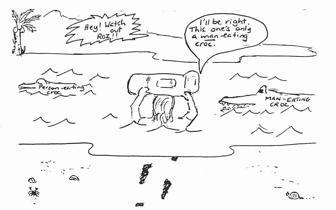
Cape Upstart lies about midway between Home Hill and Bowen, rising picturesquely from the flat, dry coastal plain east of Guthalungra. It literally sticks up out of nowhere. The highest point in the Cape is Station Hill homestead. We started the walk from near the homestead, leaving the vehicles in scrub on the edge of a saltflat. Half an hour later, after following a 4wd track through Dodonea-scrub covered sand dunes, we emerged on one of the longest beaches I've seen. It seemed to stretch all the way to Abbot Point, near Bowen. We headed north. Then we reached the creek. Much had been spoken about this creek. It was said by certain quarters that we'd have to wait until low tide to cross. Others said it was a well-known haunt of voracious, person-eating crocodiles. Still others opined that the current would be too strong to swim and would sweep us out to sea, never to be seen again. Then one strapping lad strode forward, raised his pack above his head, and stepped in (one gets the impression he would do the same if confronted by Torres Strait). When he emerged on the far bank, our spirits rose, we gave a cheer and followed suit, all the while searching for a shallower crossing than the one our hero had taken.
After lunching on a headland with view, we tackled the only real bushwalking on the trip, about 1km over a scrubby saddle between two beaches. It took about an hour, emerging onto a small beach with a grassy casuarina shaded campsite above H.W.M. This was home for the weekend.
Sunday was, to use current Public Service jargon, "unstructured", do your own thing. It usually means doing nothing. But yours truly broke out, and with a fearless companion, attempted to tackle an awe-inspiring peak to the north of the campsite, on the other side of the bay. Fearless companion fell by the wayside (sorry John, some of us just don't have it). But your gritty correspondent, remembering Scott of the Antarctic and Burke and Wills, pushed on through evermore hostile conditions (Who is this guy? Ed.) and reached the top. And I have the photos to prove it.
(The editor objects to writers putting in Editors comments)
The other layabouts? Well, they just layed about. I think Rob did some fishing.
There was some concern about some of our group returning after darkness fell. They must be blessed with good night vision. One of the highlights of the day was the discovery of a semi-permanent little hideaway on the creek from which we get our water, half an hour from the campsite. This little hideaway amongst the boulders sheltered one person, whom we called the hermit, and even had a kitchen, with utensils and a bag of flour. It looked as though it had been vacated some months earlier. The walk back was more like an amble, the creek crossing being without drama, due to low tide. We had perfect weather. The nights weren't cold, the sea was warm. A laid-back long weekend for most.
Ted Priester
JOKES
Did you hear about the Spanish fireman who had twins?
He called one Hosey and the other Hoseby. (get it? Hose A and Hose B ).
How do you know that an Irishman has used your V.D.U.(i.e. visual display unit)?
There's tippex all over the screen.
HANDY HINTS
Take candles on your next overnight bushwalk. They are cheaper than torch batteries and last a lot longer.
Use overboots (supplied by Townsville Bushwalking Supplies at $4.50 per pair) instead of gaiters. They are cooler, easier to carry and just as effective.
NEWSFLASH
Whose "shapely"? naked back-view will soon be appearing in a national magazine? (There is no truth to the rumour that the Townsville Bushwalking Club is affiliated with the Nudist Club).
ANOTHER JOKE
(Ted must not read this joke).
What do you get if you cross an owl with an oyster?
A mussel that stays up all night.
Bea Duffield
THE BASALT WALL
When I was asked by Beatrice to write an account of my trip to the Basalt Wall, I wandered what I could write about. But something happened on this trip to change all that. We got lost. I guess nearly every bushwalker has at one time or another been lost.(There's no truth to this rumour. We always know where we are. We just can't find it on the map!).
We left Townsville on Saturday morning on what seemed to be shaping up to a fine weekend. However, the South Easterlies were blowing, bringing with them wet weather. It took a few hours to reach Charters Towers and another hour to reach Red Falls Lookout. The area around Red Falls is dusty and dry as it has been in a significant drought for the last couple of months. However, Lolworth Creek was running. There was very little indication that the weather was going to turn worse as we left the cars and started along Lolworth Creek. The area around Lolworth Creek is subject to extensive soil erosion from the landscape around us. The trail we followed weaved in and out of the creek bed. The creek bed looks fairly much the same all the way along and this was what confused us later in the trip.
It's not too difficult to find a reasonable campsite if you don't mind a bit of sand. The place we chose was about 2km downstream from Canal Creek Falls. You could follow the creek down to White Falls, but if you wanted to climb out of the creek-bed here, this would involve some tricky and dangerous climbing. It is best to climb out of the creek-bed near the campsite and follow the wall around. You should have little difficulty crossing the creek-bed once you reach White Falls. This crossing is the best way to reach Canal Falls.
It should've been 3 hours to White Falls and back. However, we didn't leave until close to 3 o'clock. Six of us left for White Falls - Jim, Beatrice, Brian, Tony, Mary Jane, and myself. Ted,Glynis and Anne stayed behind. (We were the sensible ones. Gavin left half an hour later). We didn't have any trouble in reaching White Falls, but because we spent too much time at Canal Falls, we had insufficient time to make it back to camp. Through a series of stop/starts, "we've gone too far", and "we've gone the wrong way", we managed to get totally lost. By the time we had realized we were lost, the sun had set and it was getting dark rapidly. We made a last futile attempt to reach the campsite but all light was lost and we realized we might as well be walking in circles.
So we decided to make camp. Fortunately, Tony had brought a water bottle and something to munch on. Just out of habit, he also brought matches and cigarettes. We used the matches to light two large bonfires with a little bit of help from Beatrice's huffing and puffing away on the fires. As the fire started to illuminate our make-shift camp, at least our immediate surroundings were clear. There was at first some doubt as to where we had made camp and how far we had to go to reach water. But these fears turned out to be groundless. It turned out to be a short drop to the creek-bed where we made another fire and erected a small shelter around some fallen trees. We used some branches off a nearby tree to build a small shelter as the overcast conditions had led to a little drizzle. This only added to our discomfort and we began to wander if we would be wet as well as hungry and lost. The rain though fairly light was almost continuous. Although we didn't know it, it was going to pour later that evening.
Our empty stomachs kept our minds off the worsening weather. Tony had a few bits of scroggin and an orange he was going to share around at a certain time and this gave us something to look forward to. We were settling down to a sleepless night when we heard Ted calling. Beatrice went hysterical and we were overjoyed ourselves. Ted and Gavin had brought torches and scroggin. We formed a chain - each couple of people with a flashlight. Even as we left our make-shift camp, I wasn't sure which way we were heading. We had to have complete faith in Gavin in getting us back to camp. We did eventually get back to camp but we must've been a good thirty minutes upstream. My calculations are that if we hadn't assumed we had gone too far in the first place, we would have been back at camp by sunset. We were all thrilled at the amount of effort the others had put into finding us. They had made an enormous bonfire and had been scouting up and down the creek. Full credit, however, must go to Tony and his matches, for without them our night would have been wet and miserable and the search party in all likelihood would not have found us.
That night it really poured down and my tent leaked, but I was home and snug as a piggy in a blanket. I had no complaints. The next morning, everyone slept in as we all were drained from the night's little ordeal. When we eventually did get up, it looked as if it might clear. However, this was not to be the case. We eventually headed off late in the morning. The rain had turned the soil-eroded cliffs very muddy and made crossing them an entirely different ballgame. We decided to take a short detour to cut across the Basalt Wall so I could at least see what they looked like. It was evident from looking at the wall that in geological time, it was a very recent lava flow perhaps as little as tens of thousands of years old. The vegetation and wildlife was varied and unique to the surrounding plains area. Two examples I got pictures of were Bottle trees and two amazing bugs which seemed to have every colour of the rainbow. At this point, it started to rain again and, more and more, all we wanted to do was make it back to the cars in time for lunch. It seems like every trip I've been on with the Bushwalking Club it's rained. Well, rest assured, this is one I will not forget for a long time.
Bill Kinsey