Escape Magazine – September 1987
The September 1987 Escape magazine shows the club’s enduring spirit: trips to Tully Gorge and Crystal Creek, a Godwin’s Peak climb, tales from Yaminie Falls, ibis research, Kata Tjuta adventures, plus puzzles and pub nights—proof that camaraderie and exploration are timeless.
ESCAPE
Townsville Bushwalkers' Magazine
30 September 1987
Hello..........
And welcome to the latest edition of "Escape". Thank you to contributors Dave Whyte, Wendy, Glynis and Bill.
The next edition will be our last for 1987. The deadline for contributions is 25 Nov.
Mary Jane.
SCHEDULE
MEETINGS & WALKS
30 September
Environment Centre
4 October
TBA
14 October
Environment Centre
17/18 October
Tully Gorge
28 October
**Peter and Wendy's house
59 Carmody Street
1 November
Crystal Creek
11 November
Environment Centre
14/15 November
Upper Star
25 November
**Peter and Wendy's house
29 November
TBA
2 December
Environment Centre
5/6 December
Five Mile Creek
9 December
Environment Centre
12/13 December
Picnic
GODWIN'S PEAK - JUNE 14TH
As the rain drizzles outside my window this Monday evening, I still can't believe how lucky we were on this walk.
It was 14 brave souls who turned up at the Aitkenvale Post Office one cold winter morning determined to enjoy the pleasant weather we had been having. This was a pleasant change from the heat or wet weather which had been a trademark with the Townsville Bushwalkers. The trick is to plan your trips ahead of time.
As we drove to Rollingstone, the starting point of our trip, I casually put my hand out the window and was surprised how cool it really was.
The first view I got of Godwin's Peak was from the highway. It was an impressive peak with a triangular summit located just to the south of Mount Halifax.
We stuffed jackets and other warm gear into our daypacks and were on our way. We followed an almost dry creek bed for a while coming across some reasonable swimming holes, but the weather was too cool to indulge in such pleasures.
It wasn't long before we came to the major part of the walk, the long climb to the top. We filled our water containers and began the long trudge to the top, some 600 metres above us.
To say the going was steep would not be an exaggeration. It was very steep. There were more than a few times that I had to force myself to move on after a break because the angle of the land above me was not very encouraging.
As we climbed higher we obtained some fabulous views. Even Mount Halifax lost its magnificent face.
Eventually we made it to the top to enjoy lunch, a fabulous view, and some pretty cool weather. I was thankful for the sweater and rainjacket I'd brought as it was rather cool at the top.
The summit is roomy and comfortable with plenty of space. Quite frankly, if the weather had been clearer I wouldn't have minded camping there.
This is a fantastic walk and I'd recommend it to anyone as long as you're fairly fit. From the summit one can get unequaled views south to Mount Elliot and north to Ingham.
On a rating on one to ten I'd have to give this an eight. In other words, it's a must.
BILL KINSEY
The Untold Story of Yaminie Falls
(In which the true Dave Whyte mettle is revealed and certain other persons discomfited)
After an early start at 6:00, except for some people who had got it wrong and had been waiting since 5:30, we motored in our normal somnolent fashion to Abergowrie, the start of the walk.
The walk took us up the lovely Herbert river valley, here open woodland with patches of rainforest. We waded the Herbert at a shallow ford at which I demonstrated the correct procedure for crossing rivers of this sort. Strangly, people did not seem inclined to follow my example and some shorter bushwalkers appeared to be muttering things about the length of my legs!! We then meandered our way upstream along a 4WD track with views of the gorge far ahead. About mid-morning we stopped for a break on the bank of the river.
Several people were apparently convinced that the day's walk was achieved, and set about brewing quantities of tea to restore themselves and casting about for campsites.
Groans of dismay met my announcement that the Falls were yet a fair step and that we should move along to arrive there in good time. A little further upstream we recrossed the Herbert at another lovely ford. Some rather interesting river crossing styles were exhibited here including the 'its-up-to-my-shorts-teeter' and the six person shuffle. I attempted to demonstrate my New-Zealand-running-on-water technique but found that I hadn't quite perfected it.
Our lunch was by the river only a stone's throw from the ford. I had hoped to push on to an attractive backwater Ted and I had seen previously with some interesting tracks nearby, but people looked at me with horror and stated that they preferred this spot. Again a small sub-group immediately set about producing quantities of tea (is it just tea they put in those billies?).
Proceeding on, Yaminie creek appeared on our right and we turned and traced its course for 2-3 km through a narrow, lush valley to the falls. Our first view of the falls had everyone scrabbling over slippery rocks for that ultimate photo. The river dropped in a spectular cascade into a large round pool.
Once again people started casting about for campsites and complaining about the quality of the firewood for brewing tea. I had to gently discourage them and remind them (once more!) that our agreed goal was by a pool at the top of the falls. Our way, I explained, lay over a small ridge with an easy descent to our campsite. I was therefore amazed at the responses of "What, uphill? with my knees in this condition?" and "More walking? but it'll be dark soon and I'm not allowed out after dark"
Nevertheless I managed to persuade everyone to complete this last leg of our journey (journey of our legs?). On the way up the ridge I endeavoured to keep people's minds off their imagined discomforts by locating unusual specimens of the local fauna (a beautiful python), and pointing out some of the more curious members of the plant community.
Descending the other side of the ridge we traversed a pandanus filled gully to arrive at a pristine pool above the main falls yet fed by its own 10m falls. Space for campsites was somewhat limited but as I had foreseen, people agreed that the beauty of the spot far outweighed any inconveniences associated with it.
The next morning I expressed a wish to explore further upstream and was accompanied by Peter L. Other people preferred to relax about the campsite and drink in the grandeur and solitude of the place. Only a hop and a skip upstream was another pool, the equal of that by our campsite. This creek is certainly worth further exploration.
Back at the campsite for lunch the consensus was to do something energetic in the afternoon, to get the blood stirring. Consequently we popped back over the ridge to the mouth of the creek for a change of campsite. As this in itself posed no challenge to us as bushwalkers, I decided to open up a new route off the ridge. This was an improvement, though somewhat subject to rockslides.
Our campsite was close to the junction of Yaminie creek with the Herbert, and despite its expansive nature, tents were again erected cheek by jowl, one abutting another. Agorophobia? fear of crocs? or just innate friendliness?
The next day, monday, saw a relatively uneventful walk out save one episode with an important lesson for us all. Two of our group, who I won't name to avoid embarrassing them, were unable to maintain the even pace of the rest of the group. This in itself would have posed no particular problem to experienced bushwalkers though one hopes that in future they will ensure they are fit enough to keep up. No, the real problem arose when, finding themselves separated from the main party and unsure of their position (lost), they panicked and headed off wildly. Fortunately they were located without too much difficulty near the bank of the river and the day ended happily. All in all, a great walk but one with a sobering lesson.
For the future I've got a some rather more challenging walks that I think we should consider.
Dave Whyte
RUMOURS
Bea Duffield reports that there is no truth, repeat, no truth, to the rumour that either she or Gavin has a kayak for sale.
However, Bea would like it known that she might have a raft for sale. (This following a somewhat exciting(?) trip down the Tully.)
BBQ
Would you like to host one of our monthly BBQs? Ring Marion if you are interseted.
FLATMATE
Glynis still seeks suitable person to share her house in Oonoonba.
PUB NIGHT
We meet once a month (on the Friday before a day-walk) at the Metropole Hotel in South Townsville. Join us for dinner/drinks at approx. 6 pm. See you Friday 2nd October.
Townsville's White Ibis
If you are a regular contributor to the Townsville 'dump' you may have wondered where the large numbers of 'dump' ibis go when they have finished scavenging for the day. Did you realize that Townsville is fortunate in possessing one of the largest breeding colonies of white or sacred ibis in North Qld? The colony is unique in that it is very close to the centre of a town, situated as it is on the southern bank of the Ross river in the midst of a mangrove swamp.
I have been involved in the first detailed study of the ibis colony, being conducted by a member of the Wildlife Preservation Society. We measure the growth rates of the fledglings, and leg band and wing tag them when they are old enough.
There are over 150 pairs of breeding ibis and we have found that the season extends from mid July to late May, rather longer than for most birds and considerably longer than ibis colonies in southern states. In fact I don't know of any other birds that breed over nine and a half months!
The adults build nests of large intertwined twigs in the branches of the mangrove trees under the top canopy. Nests are added to year after year, and some of them reach amazing proportions, often 2 or 3 nests being joined together. Sometimes the mangrove tree has died and the nests look extremely precarious perched in its branches. The female lays 2-3 eggs usually although we have found one nest with 4 eggs.
After hatching, the baby ibis has its eyes closed and the remnants of an egg tooth on its upper bill. Within a few days its down is fluffy with black on its head and white on its body. You can fit two babies in the palm of your hand! Their beaks at this stage are only 2cm long, rather shorter than those of the adults. The baby ibis grow rapidly, feeding on regurgitated fish (or other strange and exotic leftovers from the dump, e.g. saveloys) brought by the parents.
As their feathers grow the ibis become more adventurous and leave the nest to explore in the branches nearby. Their beaks are used rather like a fifth appendage and they can recover from a fall in an amazing though ungainly fashion, hanging on grimly with their beak while their legs flail the air feeling for a branch to grasp. In some of the 'joined up' nests 9 or so youngsters will join forces, wandering freely between the nests. Parents locate their young by its call and will feed only their own chick.
The mortality rate of the chicks is very high. The major cause of death appears to be predation by snakes and goannas for eggs and very young chicks, and accidents such as falling out of the nest for older birds. Two percent of eggs and chicks die every day up to fledging. Another source of danger to young chicks may be clumsy adults as I have come across several newly hatched birds squashed flat.
After the fledglings have enough feathers they manoeuvre around the tree tops. When they are fully fledged, they congregate in the daytime in an area on the ground away from the nests, rather like a large creche. Even though capable of flying they seem unwilling to and they reach this area by walking across the swamp. This is the time they are most susceptible to attack by dogs. Unfortunately evidence of dogs in the area is common as people who live in the boats moored in the area let their pets ashore near the colony for their 'exercise'.
The birds become more independent as they become fully fledged until finally they disperse often considerable distances from the colony. In another study a bird has been found 3500km from its breeding colony.
We use ladders to climb up th the nests to reach the baby birds. The ladders are difficult to manoeuvre in the mangroves and often get bogged in the mud. Sometimes the branches are not very secure to lean against and more than once I have found myself swinging in mid-air after the ladder has calmly slipped sideways. Bird lice and sand flies are in plague proportions and we go through extraordinary amounts of Rid. Lately spring tides have inundated the swamp making the mud extra sticky as we squelch about. A further hazard, in case you still thought we were having fun, is that the birds don't particularly like having their head and beak measured, and to show their displeasure usually 'evacuate their bowels' over the person holding them (me!) while the measurer gets to dodge. Occasionally they will also regurgitate so we can study what they ate for breakfast at first hand.
When the bird's leg is large enough it is banded with a stainless steel band carrying an identifying number. Then later, when its wing feathers are grown sufficiently, it is also wing tagged. These tags have a number in black large enough to be read at a distance. Both wings are tagged but they in no way impede the movement of the bird's wings. So far we have wing tagged over 90 birds so next time you see white ibis have a good look for wing tags. If you see one please let me know its number and the place you saw it. This information will enable us to build up a picture of the distance these ibis travel to forage, and the distribution pattern of this group of ibis.
Your swamp stomping correspondent
Wendy
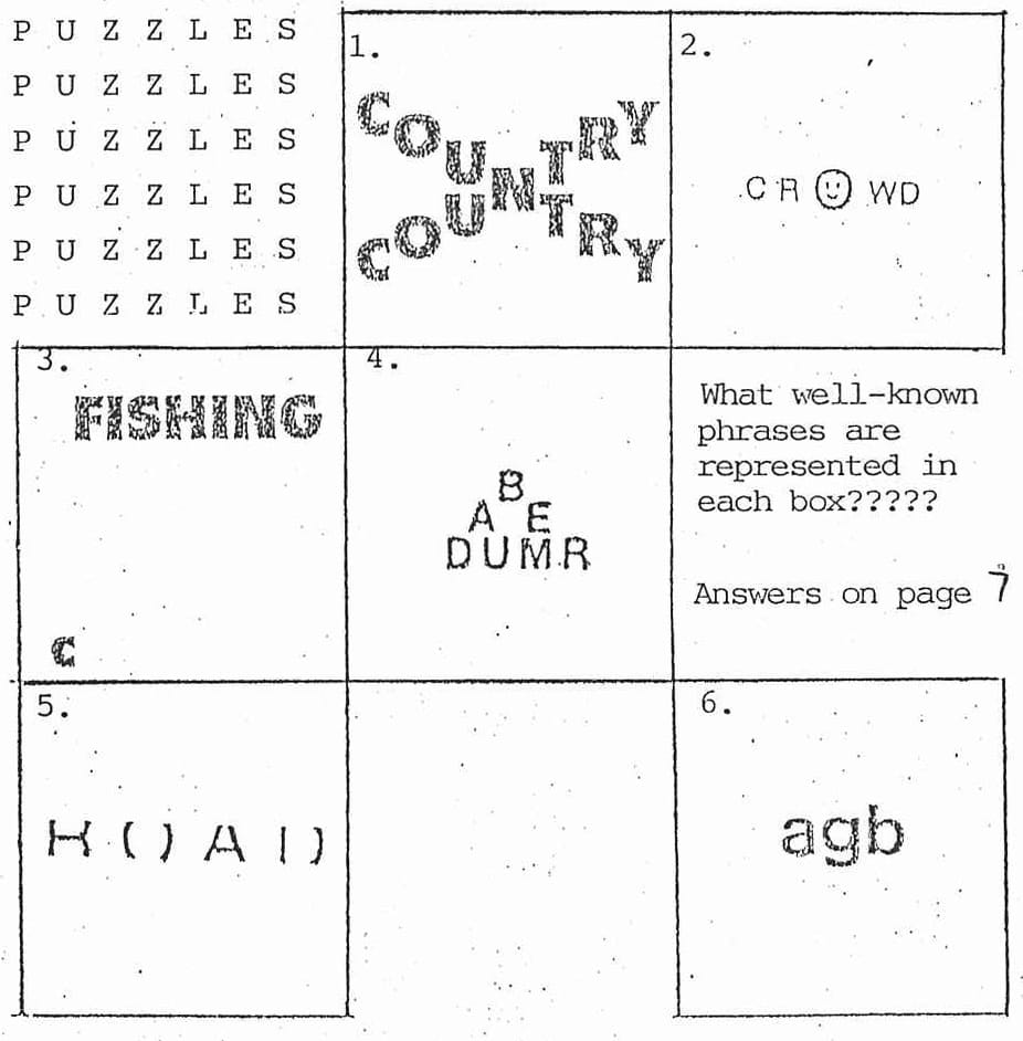
Answers:
1. Cross-country
2. A face in the crowd
3. Deep-sea fishing
4. Bermuda Triangle
5. Middle of the road
6. A mixed bag
KATA TJUTA
Kata Tjuta - the name has a certain ring of mystique about it - more so than it's more common name - The Olgas. 36kms from Uluru (Ayers Rock) lie the 36 odd-shaped domes which constitute Kata Tjuta. For those who want to see a little more of Kata Tjuta than the 2 hour bus tour, a shuttle bus will drop you off in the morning at the Kata Tjuta car park and pick you up at the Olga Gorge car park. So it was at the former place that I began my walk through Kata Tjuta.
The track leads up through two steep-walled domes and then heads up to the top of the dome on the right to Kata Tjuta Lookout where excellent views of the centre domes can be found. Each of the red ochre coloured domes is a different shape, some with hollowed-out caves from erosion.
After leaving here, I headed off the tourist track putting distance between me and the other walkers. There weren't many others taking the opportunity to explore this amazing area, but the detour I was taking was given to me in confidence, so I cannot divulge the exact location of this part of my walk. This, however, was the best part of my walk with excellent views. I was amazed to find moss-covered rocks exposed to this hot Central Australian sun, and the variety of wildflowers including Ptilotus exaltatus (Lamb's Tails) and Senecio gregorii (Yellow Tops). In fact, there's quite an abundance of vegetation inside Kata Tjuta. There was a 360° spread of canvas of red ochre dotted with splashes of light and dark green interspersed with occasional spurts of wildflower colours of yellow, white, purple and pink. The problem with straying off the beaten track however, is the burrs which are quite sharp and cling tightly to any passerby.
Back on the tourist track, there is a walk through the Valley of the Winds which is a narrow gap between two steep-walled domes. The track meanders through a delightful patch of vegetation including acacia murrayana who's golden flowers provided a pleasant change from the walls of red ochre. From here, one canbacktrack and go through Olga Gorge to the car park. However, it was suggested to me that as there's a spot with a 10 ft drop, it would be wiser to walk through the Valley of the Winds, around the outside of the domes and up Olga Gorge. In this way, if I couldn't climb up the 10 ft drop, I could just walk out again. I followed this advice.
I saw a few Port Lincoln parrots on the way and then headed towards Mt Olga. Mt Olga at 546m is higher than Uluru at 348m. The climb through the gorge takes one through some interesting rocky areas. Crawling in and out of boulders, I finally came to the 10 ft drop. At this spot, there's a pile of rocks stacked on top of each other. I had three attempts at scaling this, but to no avail. I turned back, vowing to come back one day with some tall companions.
I was later told that the view isn't all that great further up anyway.
As the sun slowly sank into the horizon, so ended an interesting and enjoyable day of wanderings in Kata Tjuta.
G.Lee.
SLIDE NIGHT
IF YOU WANT TO SEE SLIDES OF THIS AREA AND OTHER AREAS IN CENTRAL AUSTRALIA THERE'S A POT LUCK DINNER/SLIDE NIGHT AT:
36 SHANNON ST, CONOONBA
at
7.00pm on SAT. 24TH OCTOBER, 1987.
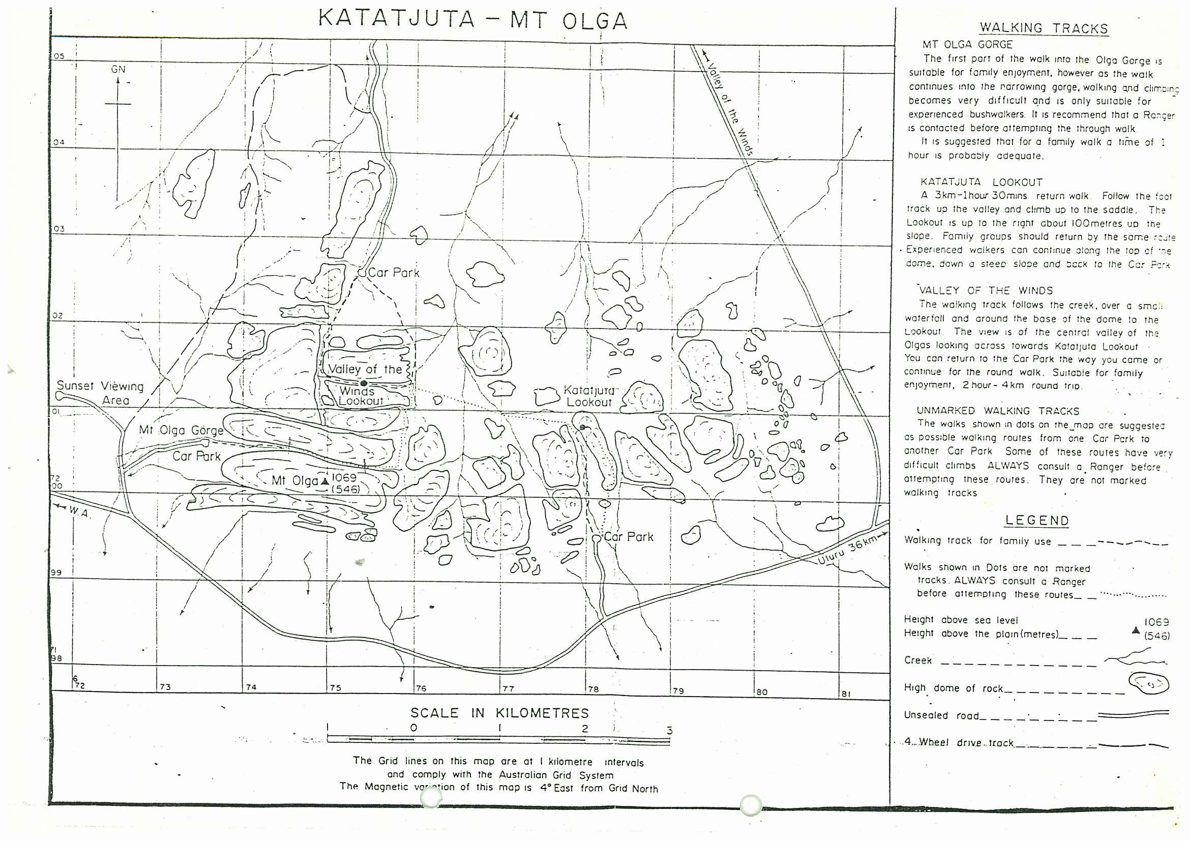
KATATJUTA - MT OLGA
WALKING TRACKS
MT OLGA GORGE
The first part of the walk into the Olga Gorge is suitable for family enjoyment, however as the walk continues into the narrowing gorge, walking and climbing becomes very difficult and is only suitable for experienced bushwalkers. It is recommended that a Ranger is contacted before attempting the through walk. It is suggested that for a family walk a time of 1 hour is probably adequate.
KATATJUTA LOOKOUT
A 3km - 1hour 30mins return walk. Follow the foot track up the valley and climb up to the saddle. The lookout is up to the right about 100 metres up the slope. Family groups should return by the same route. Experienced walkers can continue along the top of the dome, down a steep slope and back to the Car Park.
VALLEY OF THE WINDS
The walking track follows the creek, over a small waterfall and around the base of the dome to the Lookout. The view is of the central valley of the Olgas looking across towards Katajuta Lookout. You can return to the Car Park the way you came or continue for the round walk. Suitable for family enjoyment, 2 hour - 4km round trip.
UNMARKED WALKING TRACKS
The walks shown in dots on the map are suggested as possible walking routes from one Car Park to another Car Park. Some of these routes have very difficult climbs. ALWAYS consult a Ranger before attempting these routes. They are not marked walking tracks.
See the full Escape Magazine Sep 87:


