Garrawalt 3 day 2015
Townsville Bushwalking Club's Garrawalt Creek 3-day hike swapped Orpheus Island for Wallaman Falls. Camp by the creek, explore rapids, reach the spectacular top falls, discover a beer keg, and dream of Flagstone Creek adventures.
Garawalt 3 day : 3-5 October 2015
Original plan was a three day trip to Orpheus Island. We cancelled that due to strong wind warning and terrible boating conditions. We could have taken surfboards for the 2.5 to 3 metre waves, but decided against that too.
‘What’s the back up plan?’ Phil asks. I reply ‘Don’t have one, I am jinxed this year with weather and conditions, I give up’. Blencoe and Goshen booked out, school hols and long weekend therefore any popular spot should be avoided. Coastal showers forecast means another attempt on Waterfall Creek not likely to succeed, nor Broadwater. Lack of water in some of our favourite creeks rules them out too.
Wilfred suggests Wallaman, I add we may as well push onto Garawalt as an easy three dayer and get to top of the falls, and a plan is developed.
Basic plan is hike in to Garawalt Creek bridge Saturday morning and make base camp, explore down to rapids 1 km downstream in afternoon. Sunday a full day bushwalk down Garawalt Creek to the falls (3km), see what we can achieve there, return to camp. Monday morning, side trip or relax, hike out in afternoon. But researching topo maps and Google Earth, Flagstone Creek falls looks interesting too, and only 8 km road hike west from Garawalt bridge –hmhmhmhmhm. Get topo maps, delete any references to old mines etc so Wilfred can’t get distracted, and we are all set.
Saturday
Eight participants planned, six walking and two on pushbikes. One of the bikies has an unintended morning nap so they will meet us later. Six of us meet at Ingham at Andy’s Roadhouse. Andy tells Wilfred about old mines up past Wallaman – Oh No !!! Proceed to Wallaman Falls, and start hiking at 9:15 am. The hike is an easy but boring 13 km forestry road to Garawalt Creek. The pace was set high by two females. Along the way we find a young Army fella (Will) having a cuppa, and he joins us for the walk along the road, and the rest of the weekend. Then the two Hells Angels riding their pushbikes pass us. A nice brisk morning hike (2 hr 20 minutes) to arrive at the camp site at 11:35 am. Set up camp and have lunch. There is an old bobtail here, interesting bit of history from the forestry days.
At 1:30 pm we go exploring, down to the bridge, then downstream along creek bank bushbashing for about 1 km to the rapids, 40 minutes. Exploring the rapids, but rain arrives so we scamper off the rocks into the scrub, then bushbash over the bluff to above the rapids and back to camp arriving 4 pm. With some encouragement the two Hells Angels set off on a mission to Flagstone Creek 8 km ride further west to see if they can get to top of Flagstone Creek falls. Angel 1 was keen, Angel 2 took some convincing. For those at camp, happy hour at 5 pm, and we became cheerier as the night progressed. Gazza produced two beers, on ice! Yep, he carried beers and 1.5 kg of ice in his pack ! A good bench seat was assembled for two to enjoy. The two Hells Angels return about 5:45 pm, Angel 2 looking hot and worn out somewhat. They presented their report and photos of the Flagstone Falls and gorge. This is an option for a side trip Monday morning, albeit maybe not as easy as I thought. Overhead the cockatoos are very noisy, and the strong wind howls through the trees.
Sunday
Awake to screeching birdlife and a wet morning. Some had wet clothes and gear from being left outside during the night. The bench seat had disappeared, reportedly there were sounds of it being dragged off into the forest during the night by wild creatures unknown. So two unhappy campers at breakfast with no bench, they were disbelievers of the story. But after some hints, they found it behind a tree, nice and dry.
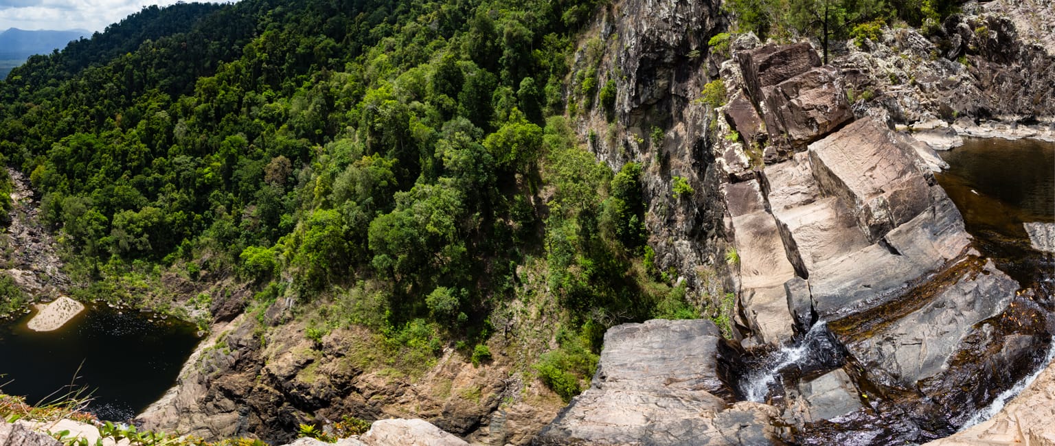
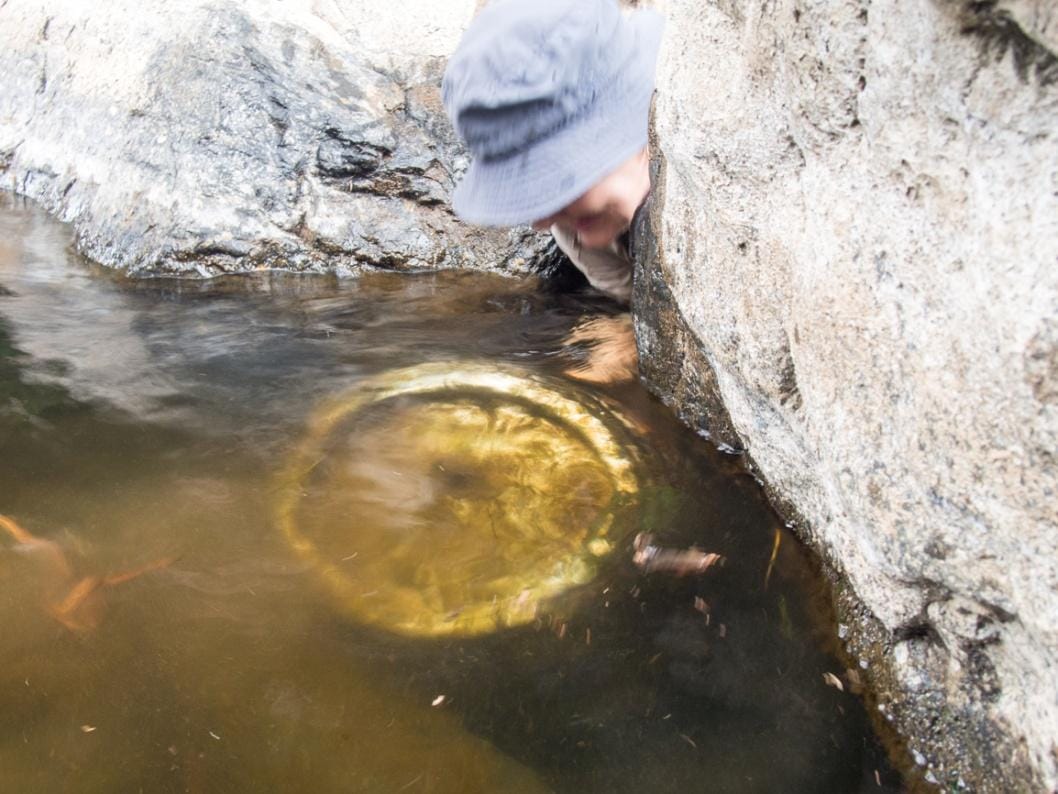
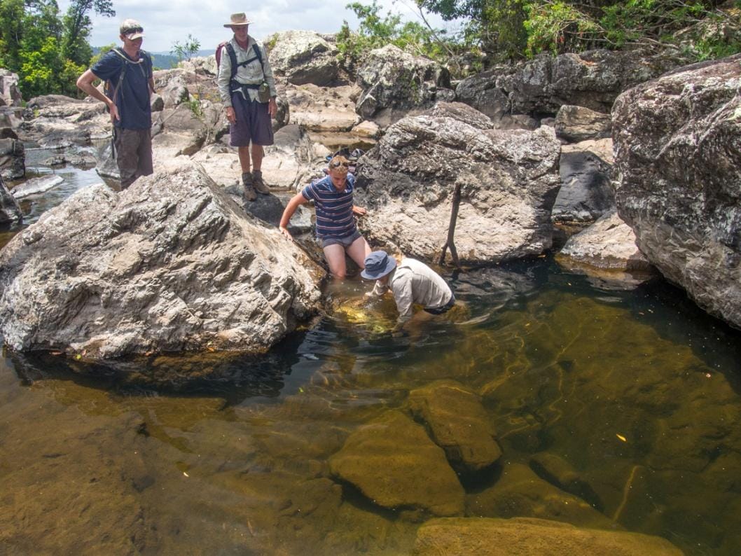
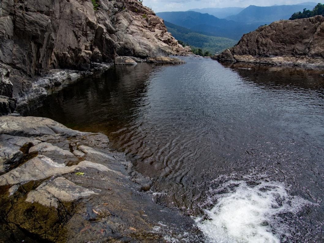
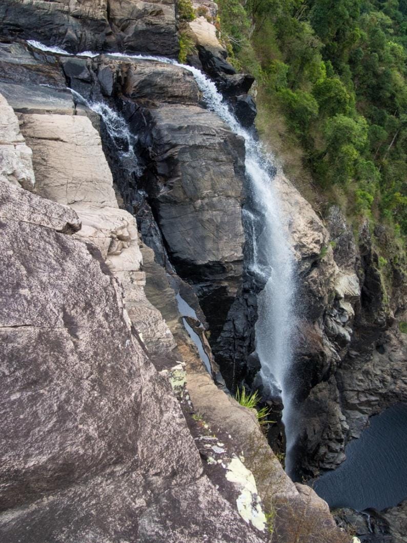
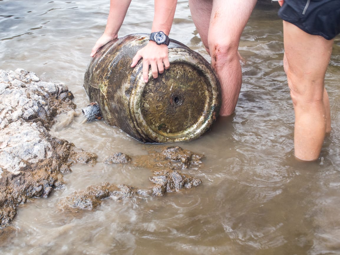
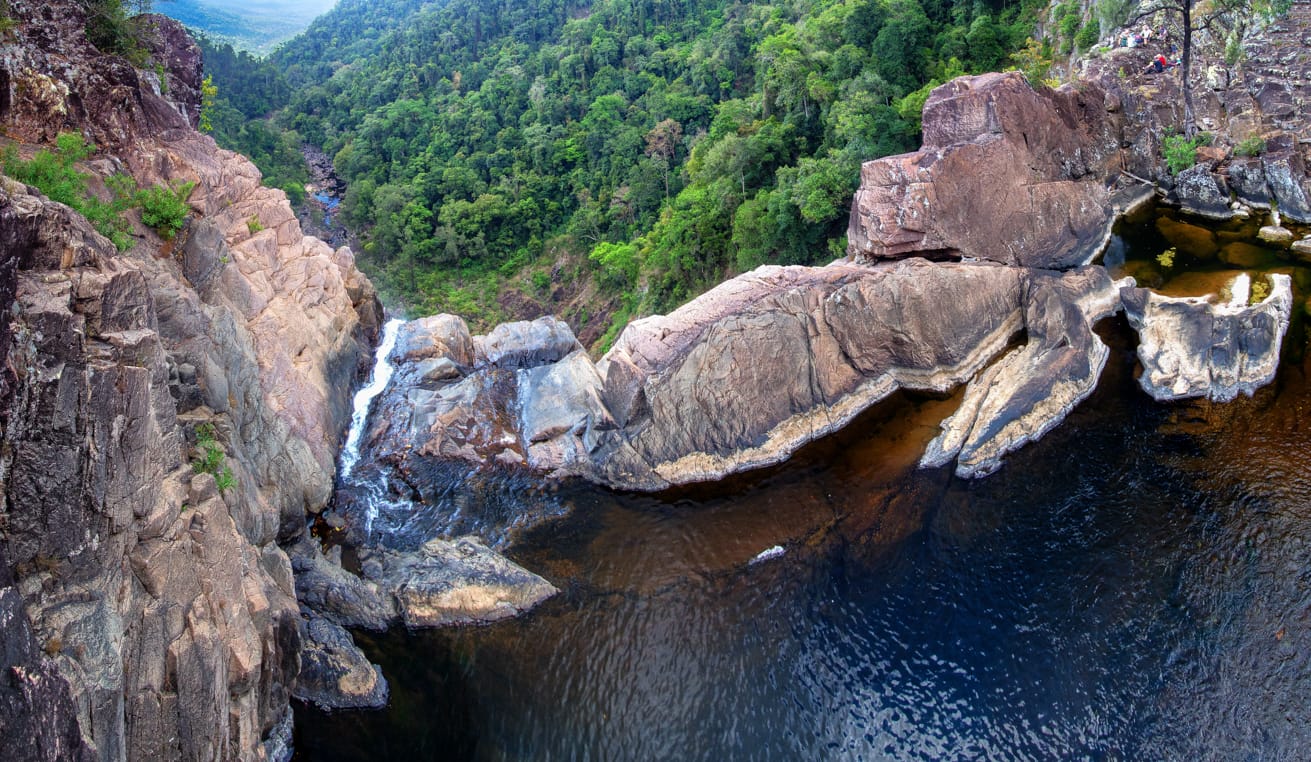
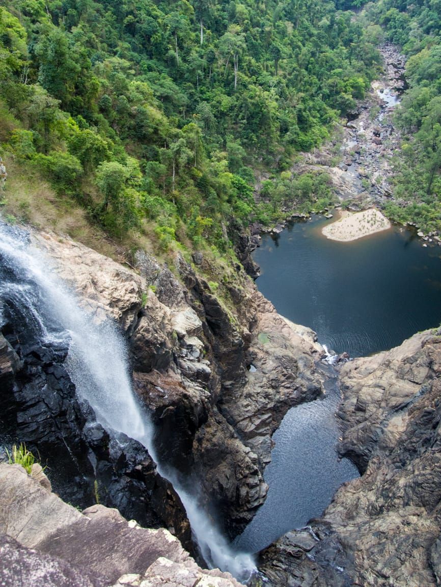
Start bushwalking down Garawalt Creek at 8 am, right hand side of creek. Top of rapids cross to left side and proceed down the creek, mostly along creek bank in forest. Further downstream we cross to right side, to enter a wild mess of brambles and other crap. Funnily enough, we had just changed walk leaders, Wilfred just happened to be in front now to enjoy the brambles ! We get through this, with some cursing, then pass one stinging tree plant. Then someone down the back remarks the other side looks clearer - it always does. Out of the creek bank to rocks in the creek, looking ahead, the right side looks wild, so go to left bank. Sometimes we find small beaches as substitute for Orpheus for Hells Angel 2, but she expects champagne and strawberries on her beaches as well – bad luck. Hard to impress. Short while later through a small set of rapids with nice pool then a beach and another pool. Wilfred exclaims ‘the rainforest disappears’ - ahead, the horizon was all sky. We arrived at top of the falls (at 500 mr altitude), 2 hours bushwalk from camp. Scramble down a cascade to the main drop, sit on top of the spectacular 80-100 metre sheer drop and high cliffs. Sky looks threatening, so we decide any thoughts of going further are not feasible today, and stay at top of the these falls for 2 hours. Downstream we could see where the bottom (and larger) falls would be, and Flagstone Creek gorge on the left, and dream of future exploring. To measure the waterfall drop one enterprising member threw rocks over the edge to count how long the drop took. Or was it the kid inside her coming out - there was a comment ‘thought under 18s were not allowed …’. Around midday, I say time to move to a lunch spot, had enough here. Dismay from most – why leave this great spot ? ‘well, I am bored, and need new photo location’. Plus with the sky looking threatening, time to get away from cliff edge me thinks. They followed anyway, 100 metres upstream to the beach and pool, and that was lunch ! Brent spotted a disc like object submerged wedged under rocks in the creek, closer inspection revealed it to be a drum of sort. With enterprising activity from Joy, knee deep in the creek, after much effort (under wise supervision and instruction from three males) this item was extracted from its rocky watery grave and revealed to be an 18 gallon beer keg. Some slept on the beach through this excitement. Wilfred then went exploring to find a stinging tree forest the hard way. After another good break, we dawdle upstream back to the top rapids and another break here. Then back to camp, with a new leader (Puddles) even with borrowed secateurs and madly trimming the route as she led. At camp, a shower of rain. Happy hour at 5 pm (again), and we became cheerier as the night progressed (again). Cockatoos very noisy overhead (again). Discuss plan for Monday, side trip to Flagstone not feasible due to wet conditions (plus makes for a very long hard 30km+ day in total), so we will go back to the cars and maybe explore Wallaman Falls. Flagstone can wait for another trip. Try convincing the Hells Angels of another side trip recon they can do for us (for our benefit) but Angel 2 is now recalcitrant. 9 am departure planned. Wilfred had his radio so we listed to the second half of the grand final.
Monday
3:30 am, rain falling. 6:30 am we are all up, a wet camp site. Noisy birdlife around again. While packing up it rains, just for a bit more challenge. The walkers depart early at 8:10 am, leaving the two Hells Angels who will catch up. Angel 2 says ‘hey, what happened to the 9 am departure ?’ - the response is ‘didn’t you get the memo last night?’. A bit past half way at 9:30 am we have a smoko break, the bikies catch up here. Then we continue to reach the cars at 11:10 am. Due to intermittent rain, we decide exploring bottom of Wallaman Falls not feasible. Then it rains more as we change clothes. Quick side trip drive to Wallaman Falls lookouts for 30 second look in the rain and mist (17 degrees at midday), then drive down the range in misty rainy conditions.
The Vice President’s idea is a café in Ingham for lunch – where we ask ? ‘oh well, you know, near the servo, where the shops are, run by Thai people, they serve fish and chips too”. Her directions are vague, but I figure I can find this café, and go ahead. In Ingham, can’t find it or one open, so park car and ring the other car. Then over the phone, during a mass of confusing discussion, she exclaims ‘oh, the café is in Cardwell !’. ‘What the ………!!’. So off to Andy’s Roodhouse we go. Lunch, then we make our way home.
The top falls of Garawalt Creek are impressive and well worth a visit. It was a good trip, easy walking, but the weather was not kind and precluded further exploring.
I chastised the Vice President, telling her that VP is responsible for organising weather and she has done a lousy job this year with weather.
An easy weekend, we shall have to make the next few activities harder to make up for it !
Key Info
Maps –
Start point is Wallaman Falls Stoney Creek day use car park. Allow 2.5 hrs drive (163 km) from Townsville. Wallaman Falls is 49 km south-west of Ingham, 1hr 15 min drive.
Wallaman Falls Stoney Creek day use car park to Garawalt Creek bridge is 13 km (2.5-3 hours) forestry road hike west of Wallaman Falls campground. Or you can ride your push bike in to save time. It is a fairly flat road with a few undulating and slight gradients.
Usual three day remote camping and bushwalking stuff.
Next to Garawalt Creek bridge there is a dirt pad (hard ground) that could be used for camping. About 250 mr before the bridge there is a grassed area of the old forestry camp that we used.
Water resupply available at Garawalt Creek.
National park camping permit required.
Potential stinging tree in this area (there is some along creek bank and in rainforest near falls).
There are rapids 1 km down from the Garawalt Creek bridge which makes a good short afternoon or morning excursion. Go down right hand side of creek. 30 minutes one way.
Garawalt Creek bridge to Garawalt Falls top is 3 km creek rock hop bush bash. Allow 2 hours.
Garawalt Creek bridge to Flagstone Creek Falls is 8km road hike or bike ride one way.
Historically the club has walked Garawalt as a multi-day through walk from Herbert River (Abergowrie - Gowrie Creek region) up Garawalt Creek, traverse the multi drop waterfalls, then up to the bridge and back to Wallaman, with a few variations on the last part.
Options – Flagstone Creek Falls. Also further west there is Herke Creek Falls and Sword Creek Falls.
The beach about 100 metres from top of falls is suitable for small group camping. A small group could hike in day one to the beach above the falls (5 hrs walking from Wallaman), set up base camp, then day two go down right side around cliffs of falls to reach bottom falls. Or ride bikes to the bridge then walk to the beach (1 hr ride + 2 hr walk).
Future Options
For a through walk, to avoid private property access issues and concerns of wading the Herbert River at unknown area (QPWS warns of crocodiles in area), we could start from the Yamanie gate, cross the Herbert there (the Hebert Gorge walk Yamanie crossing point), then east along the great walk on south side of the Herbert to mouth of Garawalt, then up Garawalt Creek. Or start from Henrietta gate to avoid crossing the Herbert, but that is a longer hike in (25 km to Garawalt mouth).
Through walk - Yamanie gate to Wallaman via Garawalt Creek
Yamanie gate to Yamanie great walks turn-off — 9.5km (allow 2.5–3.5hrs) river crossing, track walk
Yamanie great walks turn-off to Garawalt Creek 4.8km (allow 1.5 hrs) track walk
Up Garawalt Creek to base of bottom falls. Creek walking
Ascend Garawalt bottom falls, then the top falls, camp at beach top of falls or if large group at bridge.
From bridge, road hike to Wallaman 13 km (3 hrs).
Circuit walk - Start / finish Wallaman.
Or to avoid the car shuttle, start and finish at Wallaman. Hike along the Wallaman section Great Walk all the way down to mouth of Garawalt, then up Garawalt Creek back to the bridge, and back out to Wallaman.
Wallaman Falls to Pack Trail campsite — 23.3km (QPWS - allow 1 day). Explore top of Flagstone along the way.
Pack Trail campsite to Yamanie turn-off — 4.7km (allow 3–4hrs)
Yamanie turn-off to Garawalt Creek 4.8km (allow 1.5 hrs)
Up Garawalt to base of bottom falls. Camp ?
Ascend Garawalt bottom then top falls, camp at beach top of falls or if large group at bridge.
Road hike to Wallaman 13 km (3 hrs).