Hinchinbrook Island Exploratory Weekend
Explore Hinchinbrook Island with the Townsville Bushwalking Club’s 1962 canoe and walking trip. Covering 32 miles by canoe and 5 miles on foot, the party discovered crystal-clear springs, Zoe Bay’s tropical beauty, and rugged mountain backdrops—a classic North Queensland adventure.
Date:- 20 & 21 Jan. 1962.
Party - Townsville Bushwalkers. Graham Maltby and Roy Lane.
Type of outing - Canoe trip with some walking.
Rating - medium.
Distance travelled by canoe - approx 32 miles.
Distance walked - 5 miles.
Road transport - Land Rover, supplied by Goobs.
Distance travelled by vehicle: 90 miles each way.
Maps used:
1 mile/inch Cardwell military sheet.
1 mile/inch Ingham military sheet.
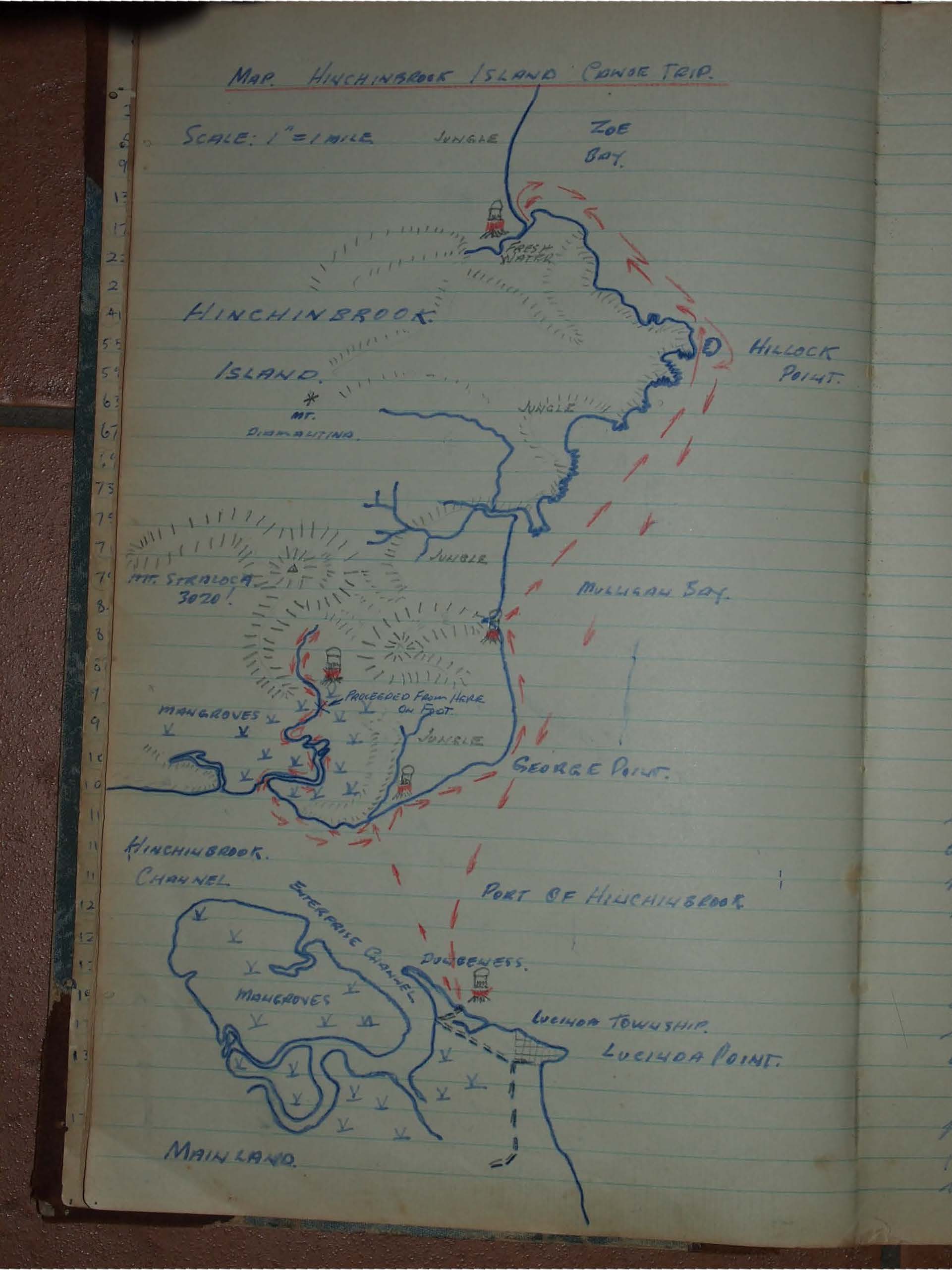
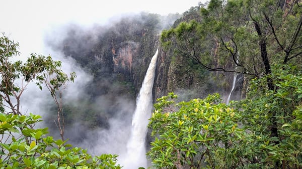
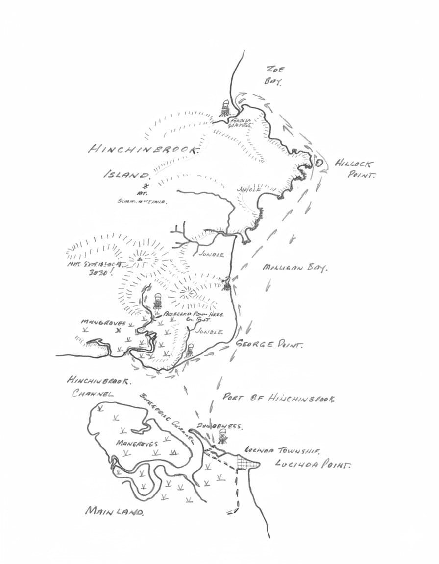
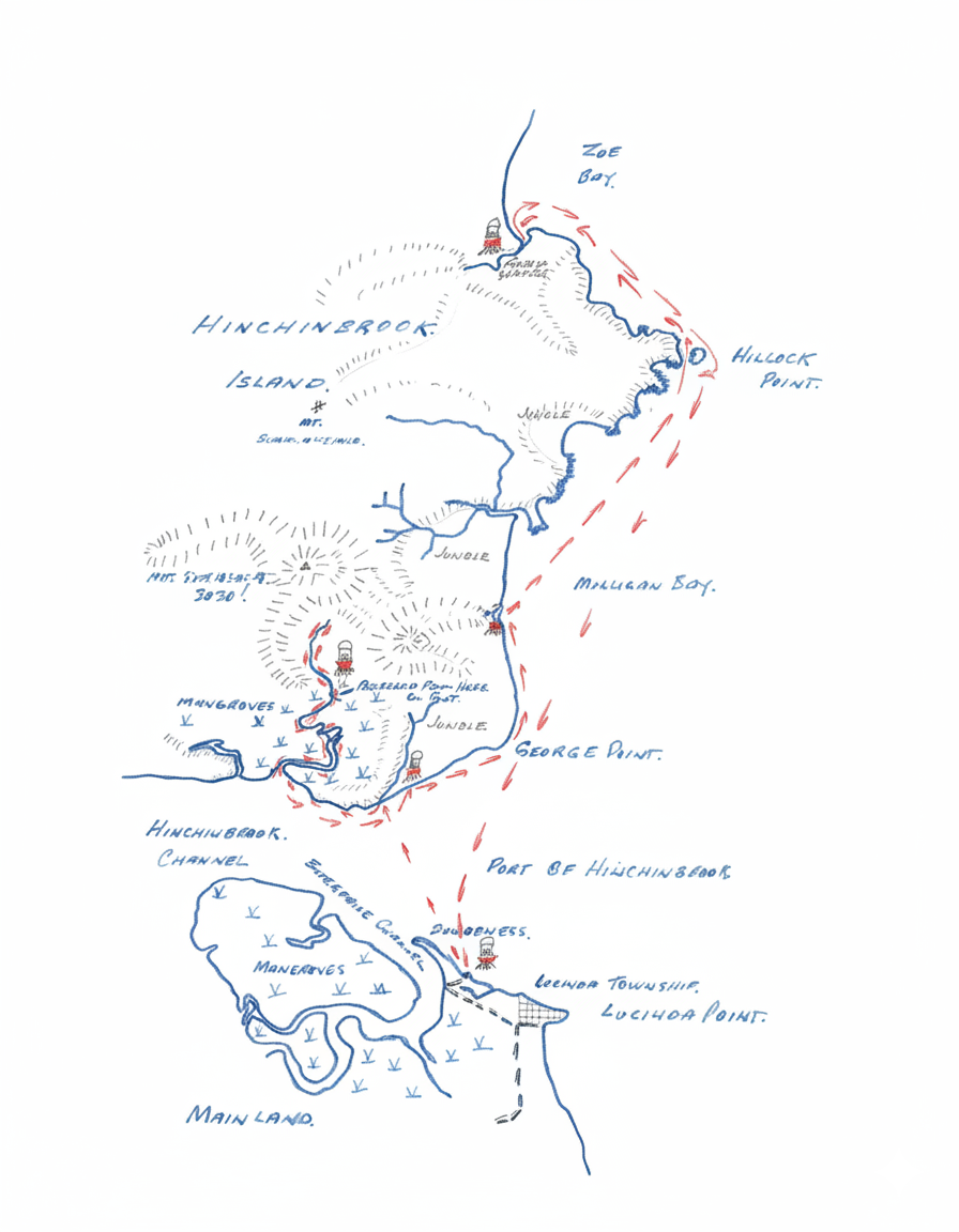
Dungeness beach was dropping astern by 7AM on Saturday. After some dodging on the way, we reached the point where we had to proceed further up Mt. Stralock on foot. (340805 1 mile Cardwell). (This point can only be reached easily at high tide in a canoe). Actual crossing time of the channel was a bare half-hour. After this there was about 2 miles of mangrove creek to negotiate. (Take 2 left branches where the creek forks). After searching for some time Graham found fresh water in a rocky creek (locally called waterfall Creek division). Following this up we found traces and signs of a track leading up it. Knowing that the track to the crashed aircraft was in this vicinity, we immediately suspected that this was it, and followed it up the creek to an altitude of about 1500ft, where we lost all signs of it. At this we decided to descend, since it was after 4pm and the going getting more rugged and difficult.
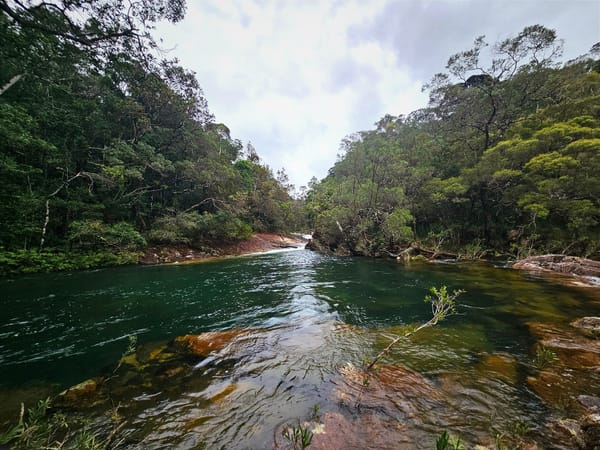
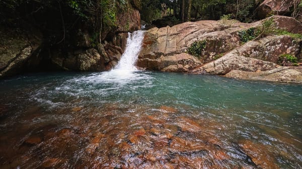
The stream is like a tunnel through the jungle, easy walking, but stiff in places. It is cool and shaded and the most striking spring is to be seen bubbling from under a great stone, on the left bank just above the big pool with its sloping flat rock wall. The water is absolutely crystal clear, and tastes like no other water could taste (even better than beer, we reckoned). It is so clear and fresh that unless there is a ripple on the water, you cannot tell if there is water in the pools or not.
The pool near the flat rock is something to see indeed. It is possibly 15 feet deep, and every detail is discernible on the bottom. But the most eye-pleasing blue-green tinge is present and makes the bottom stand out in minutest detail. It was worth all our paddling and climbing just to follow fountains at the spring, stare into the fascinating depth, and wonder at the perfect chambers and perfection of nature.
At dusk we reached the mangroves again and set to to cook a good stew. The moon was just rising (8pm) as we began the task of pushing, pulling, carrying and bridging the canoe over the 50 yards of mud so black, adhesive and gooey as only mangrove mud can be.
Being full moon, we were able to navigate down the narrow creek without much trouble. Not a ripple was to be seen on the water anywhere. Not even a crocodile on shore. Just dead silence & stillness and a full moon over the mangroves.
After reaching the open channel, we pushed on round George's Point and pitched camp on the beach of Mulligan Bay (377875) at 11:30 PM. No fresh water handy here.
8am Sunday we brake camp and paddled on for Zoe Bay which we reached at 10:30 Am. (We found pools of fresh rain-water on the rock at 499858 and at high tide it is very easy to portage over the narrow beach between Hillock Point and the Island).
At Zoe Bay, after admiring the picture postcard tropical aspect of the long white coconut palm -and- pandanus-fringed beach, we pushed into the small creek on the extreme southern end. In about 200 yards, the salt water was replaced by cool and clear fresh running water. (Vast quantities of it running off Diamantina). The big hook would be at 379896.
Three remarkable things about Zoe Bay are:
- The rugged mountain back drop, looking somewhat like the jagged teeth of a giant and decrepit saw.
- The idyllic appearance of the bay itself.
- The presence of large quantities of good fresh water, close to the beach.
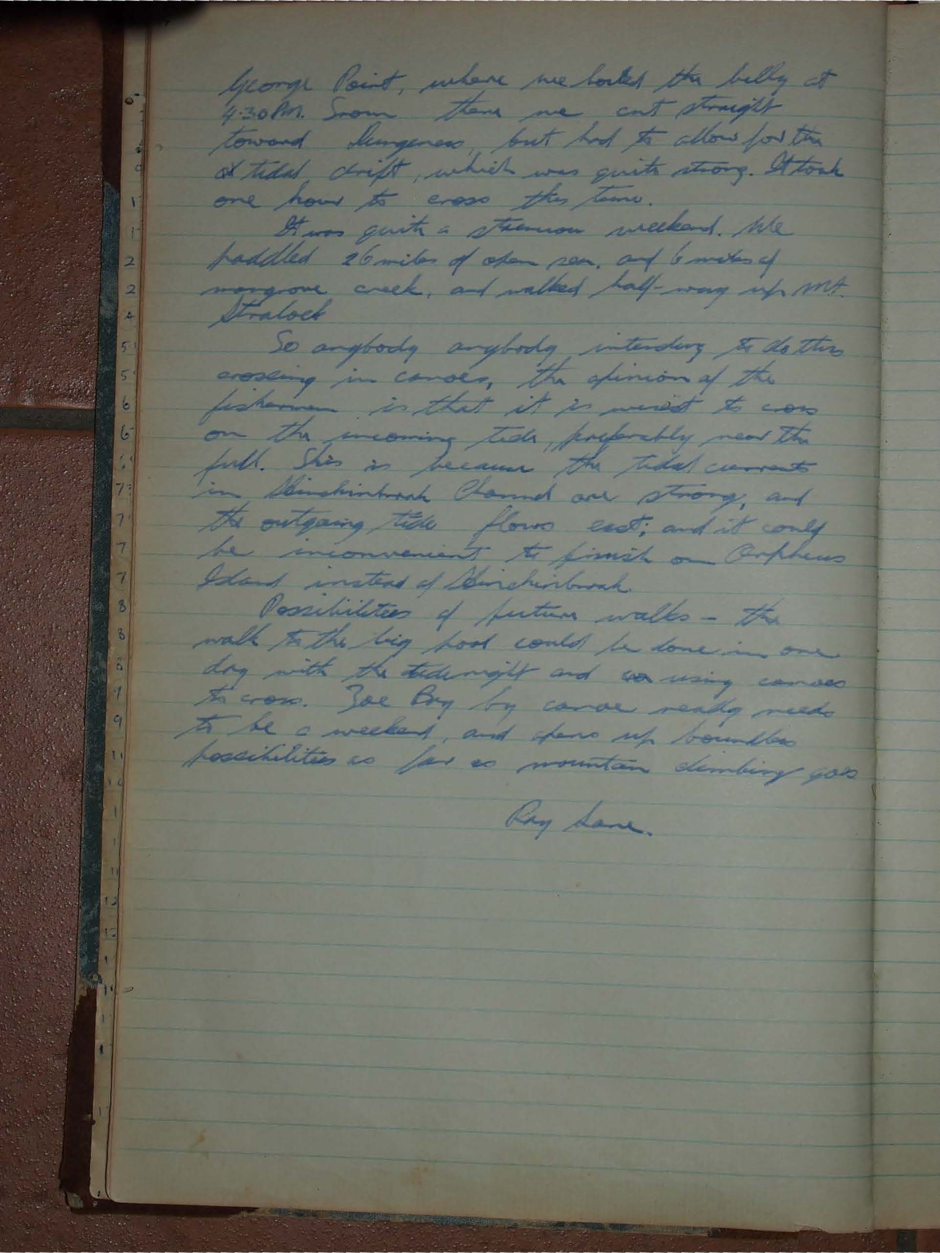
We reluctantly departed Zoe Bay at 1:30 PM and paddled continuously to George Point, where we hooked the billy at 4.30 P.M. From there we cut straight toward Dungeness, but had to allow for the N. tidal drift, which was quite strong. It took one hour to cross the Tom. It was quite a strenuous weekend. We paddled 26 miles of open sea, and 6 miles of mangrove creek, and walked half-way up Mt. Stralock
So anybody intending to do this crossing in canoes, the opinion of the fishermen is that it is wisest to cross on the incoming tide, preferably near the full. This is because the tidal currents in Hinchinbrook Channel are strong, and the outgoing tide flows east; and it could be inconvenient to finish on Orpheus Island instead of Hinchinbrook.
Possibilities of future walks - the walk to the big pool could be done in one day with the tide right and arranging canoe to cross. Zoe Bay by canoe really needs to be a weekend, and there are boundless possibilities as far as mountain climbing goes.
Ray Lane.