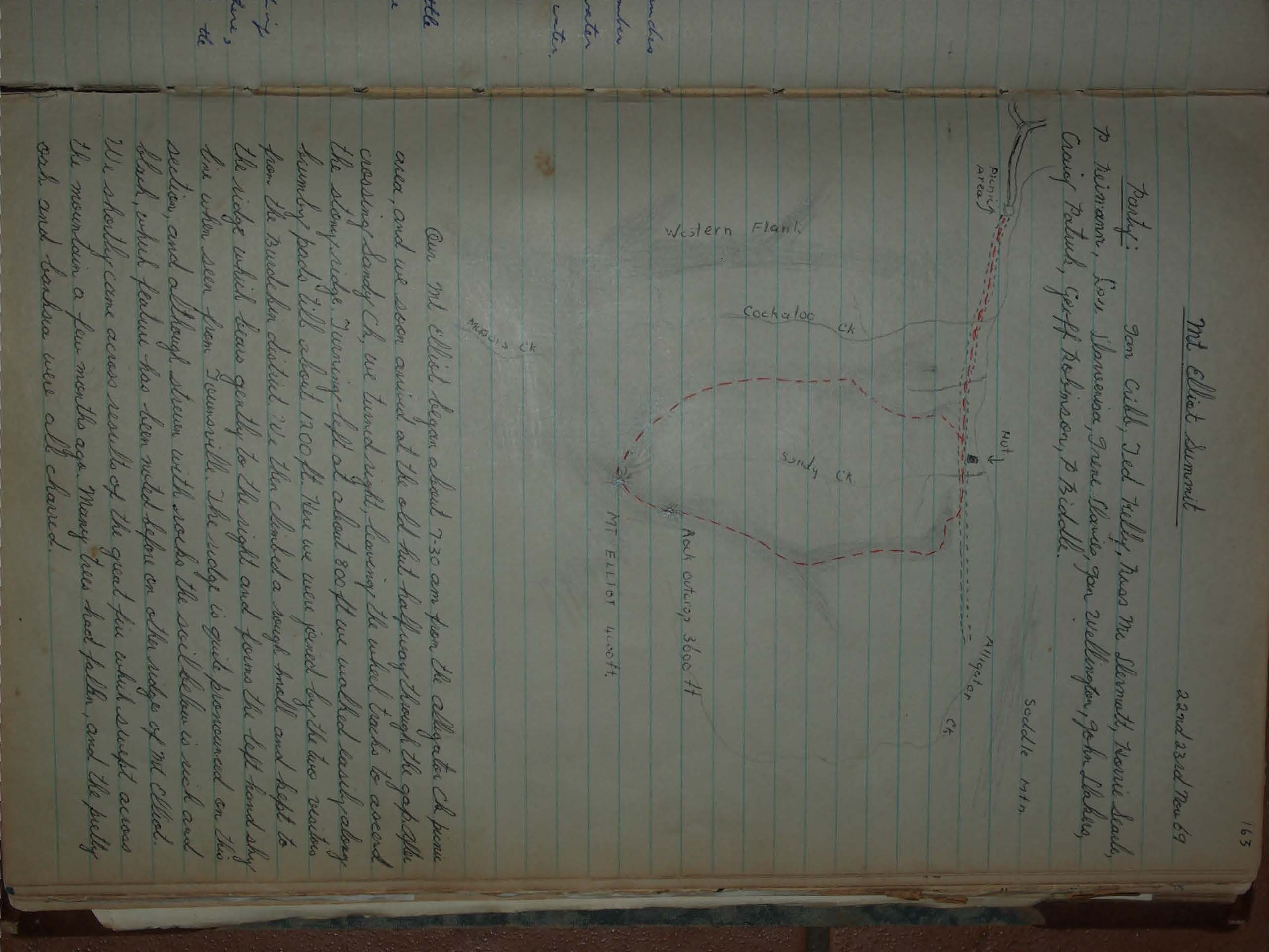
Mt Elliot Summit
Relive the 1969 Mt Elliot summit hike from Alligator Creek near Townsville. A tough two-day trek through fire-scorched ridges, dense rainforest, and rocky peaks, with dramatic views over Cape Cleveland and Cockatoo Creek Gorge. A classic North Queensland bushwalking adventure.
22nd, 23rd Nov 69
Party:
Don Cobb, Ted Kelly, Russ McSherratty, Norrie Soule, P. Reimann, Lou Stanivessa, Irene Skardo, Jon Willington, John Dakins, Craig Patulch, Geoff Robinson, & Biddell.
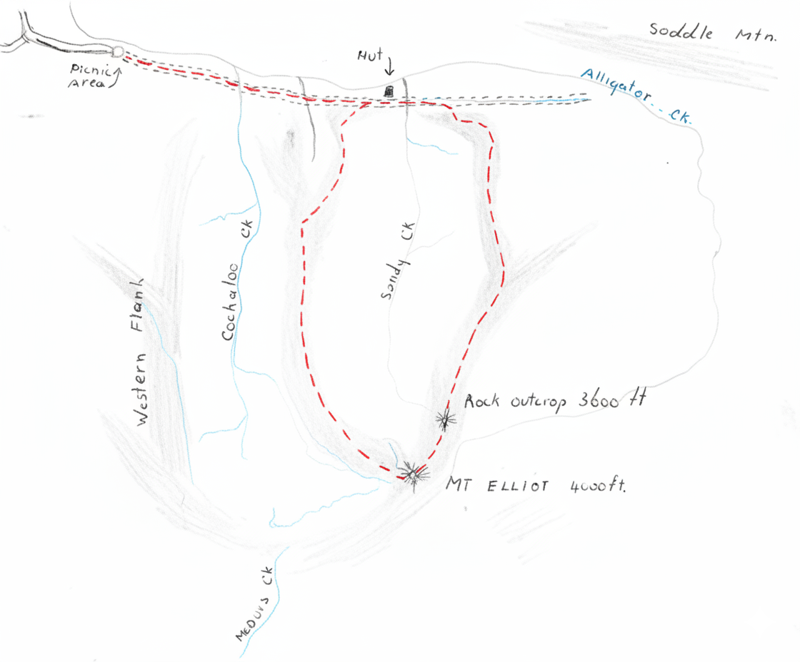
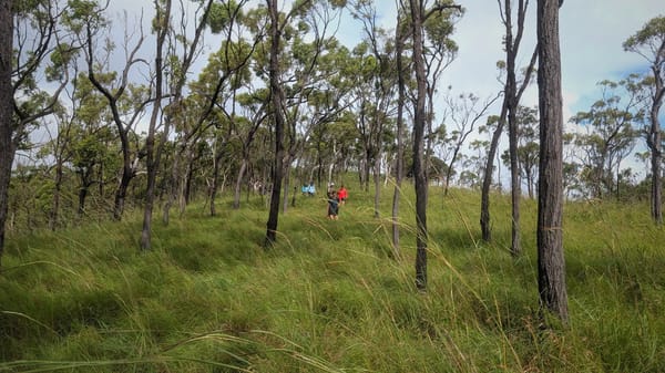
Our Mt Elliot began about 7.30 am from the Alligator Ck picnic area, and we soon arrived at the old hut halfway through the gap. After crossing Sandy Ck, we turned right, leaving the initial tracks to ascend the stony ridge, turning left at about 800 ft we walked easily along sundry pads till about 1200 ft. Here we were forced up the two ridges from the Burdekin district. We then climbed a spur. The ridge which drew gently to the right and forms the left-hand sky line when seen from Townsville. The ridge is quite pronounced on this section, and although strewn with rocks the work below is eased and black, which feature has been noted before on other ridges of Mt Elliot. We shortly came across results of the great fire which swept across the mountain a few months ago. Many trees dead, fallen, and the pretty oak and Banksia were all charred.
A halt was called for morning tea at 10.20 am and all were very glad of the break. Here the party was divided in two. Soon after moving off the forward party established a large black goanna. Altitude was quickly gained with the ridge becoming steeper and bearing gently to the right. At about 3000 ft we came to a small level area behind which lay the edge of the rainforest. We could now look down into the Alligator Ch. valley. Time was about 11.30 am.
After a leisurely lunch we began our climb up through the rainforest. Taking turns with the cane knife we made quite steady progress. We were sweating profusely as no breeze penetrates the thick growth. I detected signs of the path we had slashed on 24-25th August '58. At 2.20 we discovered an old water container on the scrub and at 2.30 arrived at the rock outcrop which forms the head of the ridge. Altitude is 3600 ft. This is the lower left hand peak of Elliot visible from Toumarville. The summit of the mountain could now be seen over a saddle and about half a mile away to the south west. Extensive views to the east, south and north were revealed by the awe inspiring walls of solid jungle forming the eastern face of the range.
A great heap of firewood was soon gathered and we began to hack out level sleeping places on the jungle floor for 12 persons. The second party arrived at 4.15 and we soon enjoyed a hearty meat, cooked over a smoky dampwood fire. Mist and cloud enveloped us on dark and as we retired to bed around 8.30 it began to rain.
All hands quickly dived out the ground under the over-hang of the rocks and with a great squash kept reasonably dry. However with a strong breeze blowing and the air generally cold, none slept very much and the night was spent mostly talking.
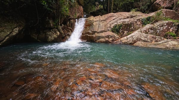
It was a rather disturbed party who greeted the dawn next morning. Rain was still falling but I expected this to lift about 8am, wrongly thinking that the rain was confined to the high altitude air. After a smoky breakfast our interest was drawn to a scrub turkey's possibly a was of the many nests in the area. Moving off on our about 8 am with little visibility we set our way down the intervening saddle. Going a little too much left we crossed the small rocky gully which is the birthplace of Alligator Ch. After replenishing water supplies we climbed up the opposing ridge towards the summit, which was reached about 9.30 a.m. a 30 ft needle shaped rock jutted skywards, near which is a tree with a single copper plaque dated 1960. As there is no view from the summit unless one is adept at tree climbing and the rain continued we voted that we should be warmer moving on.
The descent was made on the great outwards facing ridge keeping just below the ridge line proper to dodge the worst of the undergrowth. We kept the crest of the ridge to our left and the valley of Sandy Ch. to our right. We left the rain forest behind at 11 am. and continued with great pace down the heavily wooded ridge. At 2400 ft a great rock outcrop occurred and lunch was called. The party had fantastic views of the nearby country, encompassing Cape Cleveland to Castle Hill and beyond. Directly left lay the great gorge of Cockatoo Ch. jungle covered walls rising up to over 2000 ft on each side.
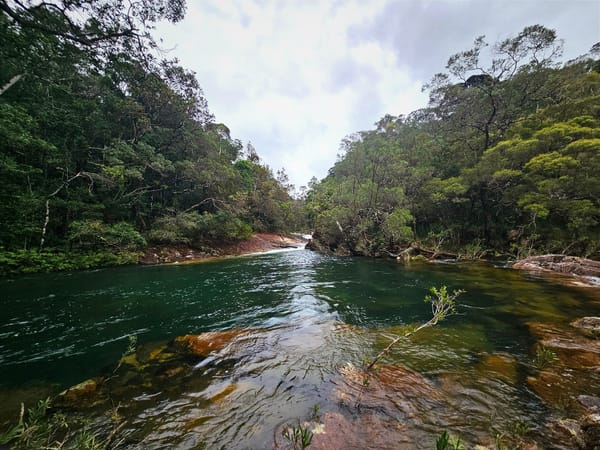
After lunch direction was slightly right onto a long sloping ridge around 1800 ft the ridge turned right again dropping off into the valley in a series of shelves. Wild horse trails were followed down, last 900 ft. and party arrived at the hut at 4.30 pm. Cool swim at the picnic area was appreciated after 40 min walk from the old hut.
Conclusions:
Although a local landmark and surrounded by roads on all sides, the Mt Elliot area is largely unexplored. The vast scale could present a trap to the unfit or unwary. However with compass, maps and a fit party the region offers some of the most rewarding bushwalking in North Qld. Weight should be kept a low as possible and long clothing worn on undergrowth covered ridges, which can be unbelievably thick.
P. Biddle.