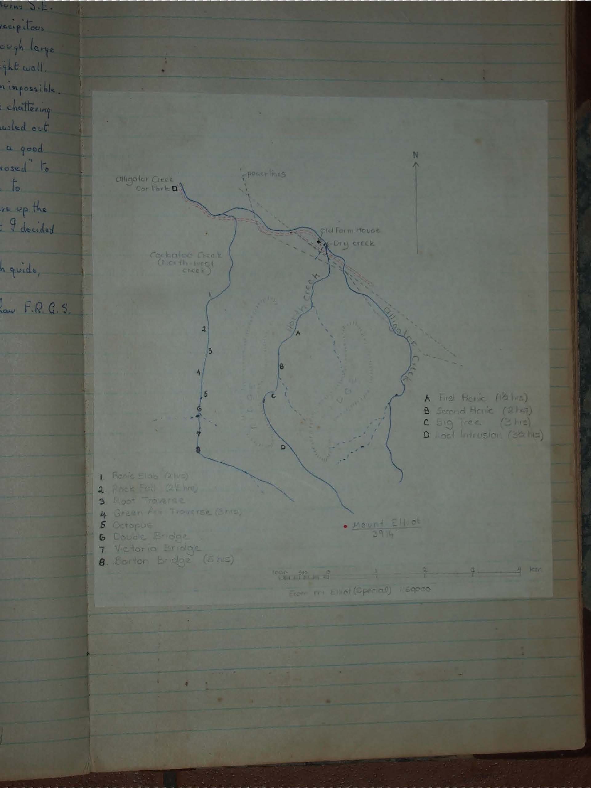
Mt. Elliott Creeks
Explore Mt Elliott’s hidden creeks near Townsville, where crystal-clear pools, waterfalls, and granite boulders create a scenic bushwalking paradise. This 1977 log details routes via North and North-West Creeks, with swimming holes, scrambles, and unique landmarks like the Octopus Tree.
1/56 Lansborough St.
North Ward.
30th August 1977.
Mt. Elliott Creeks
Foreword: I firstly submitted this report to the Club about 2 years ago, but did not write it in the Log Book, of which I had no knowledge at that time. On the request of the Newsletter Editor, Mr. Les Hyland, I now put it in that very helpful tome in hopes that it may indicate a short history of the then little-known creeks that have since come under the exploration and inspiration of Alan Simet, Les Hyland and others. I am indebted to. My colleague, Ms Jillian Reynolds, has aided my efforts with fine diagrams and sketches that greatly enhance my findings.
The Strand.
9th Sept. 1975
Townsville Bushwalkers Club
In submitting these notes for your archives, I hope you will not feel that I am a visiting interloper. Far from it, I must here stress, I have been smitten by the beauty and adventure of travel in the creeks, and only put pen to paper in the belief that they may have had some neglect in the pursuit of advantageous height and further-reaching objectives, and only wish that my words will help those, who delight, with me, in –
The Glory of the Creeks.
Mt. Elliott does not appear to merit its near 4000 feet, and, on closer inspection, its convex projection considerably fore-shortens its image of an outstanding peak. After topping its rocky summit with the Club (29-6-75) I was impressed by the upper reaches of the creek running northwards from near Mt. Elliott's highest contours. I subsequently began to investigate the possibility of better routes than the bush-clad ridges. Alan had already tried Palm Creek, but it had the disadvantage of petering out whilst some distance from Mt. Elliott.* I, therefore, confined myself to two creeks whose sources approach the summit. To distinguish one from the other I gave them the non-obligatory names of North Creek and North-West Creek.† On both, my findings on advantages or otherwise were unanimous; the advantages were predominant, as my following appendages will bear out.
N.B. I have no measuring instruments, so distances are only approximate, from memory only. Times are taken from Alligator Creek Picnic and Car Park, easy walking, 2-3 km. per hour, undertaken under dry conditions.
Advantages: (1) Much more scenic - waterfalls - longer and wider vistas, especially from escarpments. (2) More variety of scenes - every few yards, on the upper reaches, a constant change of view and also different problems of advancing. A good plan is to go up one side and descend by the other, except, of course, where climbing difficulty makes an only route. (3) Ever-present fresh water - none to carry - and, in the heat of the day, a splash in the clear, deep pools. (4) Many ideal picnic places, with dry firewood from the flood-water timber jams. (5) Heavy protective clothing is not essential - diversions into bush are minimal, and no machete is needed. (6) With longer vision, parties cannot lose one another; every member is ... TEXT CUT OFF ... will be somewhere along the creek bed. (7) Because of the nature of the terrain, no compass, nor even map, is necessary. (8) Shelter, in showery weather, under overhanging rocks. (9) Small scrambles give more balanced exercise and add interest. (10) Better chance to observe fauna. (11) Fine exercise of double-roping, if wanted. (12) No "false summits".
Disadvantages: (1) Perhaps slower, with a party unused to scrambling. (2) A rope should be taken, especially for beginners. (3) No 360° views - narrowed down to about 45°-60° and generally in the same direction. (4) Impossible after heavy rain.
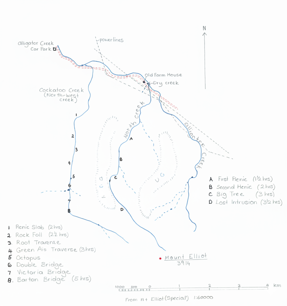
North Creek
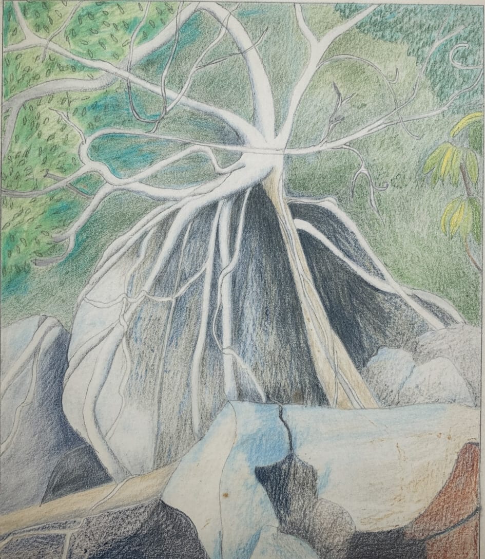
After passing Old Farm (1 hour) on Alligator Creek, follow line of pylons. The first creek is deep, the second our objective. Then 2 km. of "round stones", criss-crossing the water as desirable. (The long Pool, at start, may be avoided by a path on the left for a few metres). At First Picnic (1½ hours) are pools around 4 m. diameter. The route steepens, through large granite boulders, to Second Picnic (2 hours) where an intrusion of basalt is rock gives us a waterfall of 20 m., and larger, deeper pools. (On solo reconnaissance, I have left all gear, except rope, discarded all clothing except hat and sundsheer, as it is advantageous to short-cut through pools free of weight and wet clothing). Then comes a delightful stretch – waterfalls up to 40 m., rock-scrambling up intrusions, and sometimes tricky negotiations of great granite bosses that form the stream bed. It is even necessary to pass into a short stretch of the side foliage to avoid an impasse. Here also are large deep pools (up to 20 m. diameter) in which are many marron (crayfish), and, on my initial trip the air was thick with brown-and-white butterflies. Sometimes I have even seen the great, blue butterfly (Ulysses) and the large, velvety black one. Then comes the Big Tree (3 hours), that slopes at a steep angle up the creek bed. It is possible to walk or shuffle up the tree, but there is an alternative route, left, around the immense boulder. From here it is an easy half-hour to the Last Intrusion (3½ hours), the junction with the previously mentioned Mt. Elliott expedition. The angle eases and it is simple to walk up the creek, then strike up to the summit by the right bank at any vantage point (4½ hours). Descent is by the same route, though, for interest, seek the opposite bank to the ascent. Going down is slightly quicker (about 25%), for, by "steps", impossible to ascend, may be slid down, though continuous "rear-end" sliding can be somewhat abrasive to skin! With care, this is a most enjoyable trip – those who aspire to achievement can crown the summit of Mt. Elliott without much "bush-bashing", and those less ambitious, can laze, sunbathe or swim in the crystal-clear waters of North Creek.
North-West Creek (Cockatoo)
From the Car Park follow Alligator Creek, and, 1 km. from turnstile gate come to the first "wet" creek. This is North-West Creek (½ hour). Then follows 3 km. of 'round stone' walking, (usual to see turkeys here), when creek (now dry) turns S.E. than S. The walls constrict and we arrive at Picnic Slab, (2 hours), with precipitous side wall, festooned with the rope-roots of the rain forest. Steeper now, through large granite boulders to the Rock Fall (2½ hours), a recent collapse of the right wall.
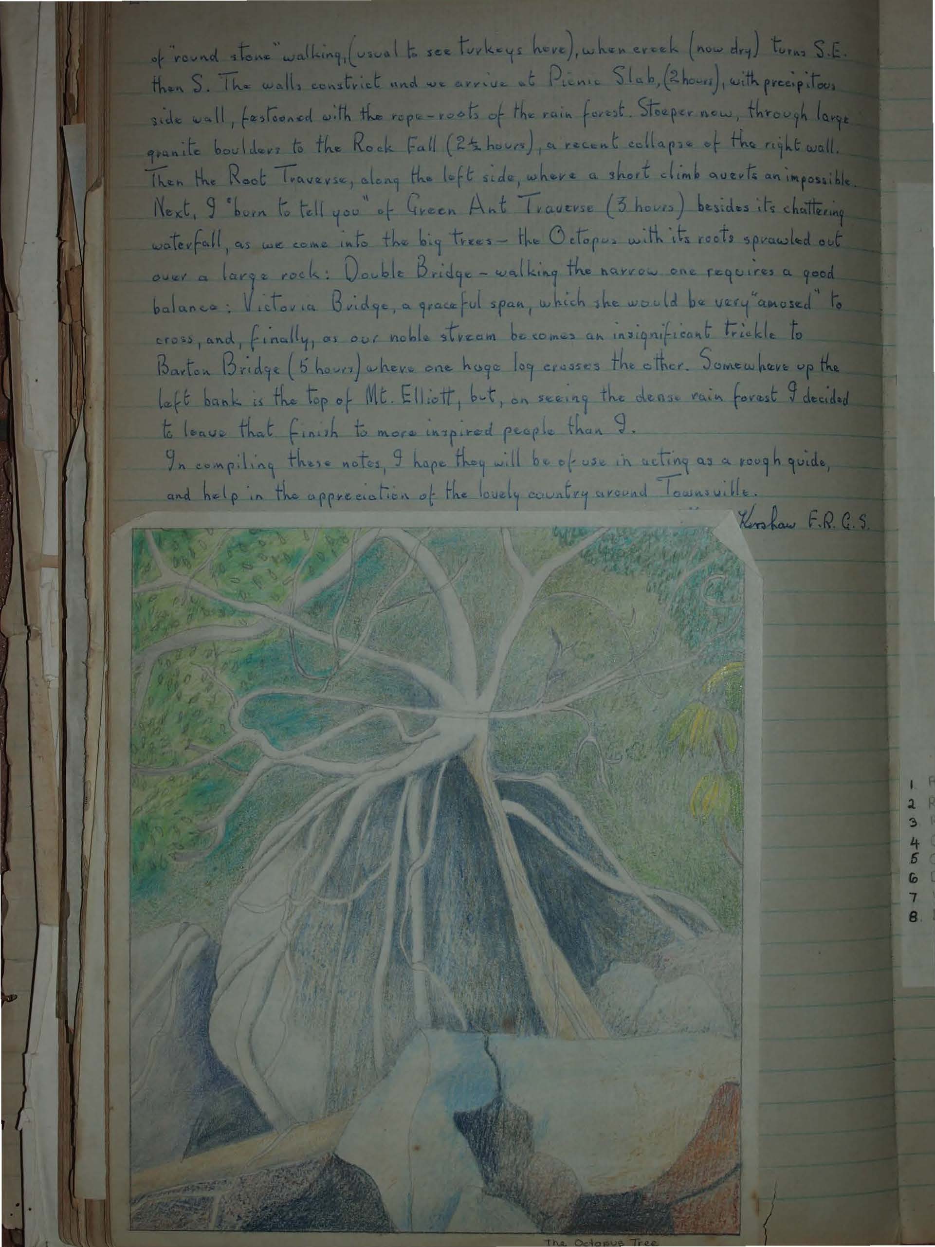
Then the Root Traverse, along the left side, where a short climb averts an impossible. Next, I "burn to tell you" of Green Ant Traverse (3 hours) besides its chattering waterfall, as we come into the big trees – the Octopus with its roots sprawled out over a large rock: Double Bridge – walking the narrow one requires a good balance: Victoria Bridge, a graceful span, which she would be very “amused” to cross, and, finally, as our noble stream becomes an insignificant trickle to Barton Bridge (5 hours) where one huge log crosses the other. Somewhere up the left bank is the top of Mt. Elliott, but, on seeing the dense rain forest I decided to leave that finish to more inspired people than I.
In compiling these notes, I hope they will be of use in acting as a rough guide, and help in the appreciation of the lovely country around Townsville.
Kershaw F.R.G.S.