TNFC Newsletter - January 1978
Relive the Townsville N.F.C. Bushwalkers 1977 adventures in the Alps and North Queensland. This December magazine features alpine trekking tales, Mt Dalrymple’s centenary climb plans, trip reports, safety tips, bushwalking recipes, and a 1978 programme of hikes across Palm Island, Conway and more.
TOWNSVILLE NFC BUSHWALKERS
Backpacking-
the hard way.
FROM: UPS & DOWNS IN THE ALPS. - ROLAND GREGORY.
TOWNSVILLE N.F.C. MAGAZINE DEC 1977.
I'M TRAMPIN TROO DER ALPS
MIT DER PACK UPON DER SHOULDER
DER LOCALS TINK I'M LOONEY
AS I JUMP FRUM ROCK TO BOULDER
DER COWS ALL STOP DER CHOOIN'
AN DER FRAULINES TURN UND RUN
NO VONDER DERS CONFUSION
COS I'M DER AUSSIE HUN.
**** TRIP PROGRAMME ****
1978
| DATE | TO | TIME | LEADER | RATING | COST |
|---|---|---|---|---|---|
| 25 Apr. | Palm Creek | 1D | Les Hyland | B | $1.00 |
| 29- 1 May | Palm Island | 3D | Ron Ninnis | M | T.B.A. |
| 5- 7 May | Mt. Dalrymple (Friday, 5th. - Centenary Walk) | 2D | Rick Williams | M | $10.20 |
| 14 May | The Sisters | 1D | Bill Dunstan | B | $1.00 |
| 27-28 May | Conway | 2D | Mark Richardson | M | $6.40 |
| 11 Jun. | Mingela Caves | 1D | Ron Ninnis | - | $2.80 |
| 24-25 Jun. | Puzzle Creek | 2D | David Blair | M | $3.20 |
RATING CODE:
| Code | Meaning |
|---|---|
| E | Experienced |
| M | Medium |
| B | Beginners |
MEETING DATES
| GENERAL MEETINGS | SOCIAL MEETINGS |
|---|---|
| April 26th. | May 10th. |
| May 24th. | June 7th. |
| June 21st. |
TOWNSVILLE N.F.C. BUSHWALKERS CLUB
P.O. Box 494,
Townsville.
Q'ld. 4810.
HON. OFFICERS:
PRESIDENT.
Alan Watson
VICE PRESIDENTS.
Ron Ninnis
Mark Richardson
SECRETARY.
Les Hyland
TREASURER.
Lily Marcellos
EQUIPMENT OFFICER.
Bill Dunstan
SAFETY TRAINING OFFICER.
Bob Ferguson
EDITOR.
Ron Ninnis
ASSISTANT EDITOR.
Chris Edwards
CONTACT OFFICER.
Marion Darveniza,
22 Banksia Street,
KIRWAN. Q'LD. 4814.
Phone: 73 1074
MEETING PLACE:
The National Fitness Office,
Cleveland Terrace (side entrance)
Opposite the old Supreme Court.
Meetings listed in this publication.
NOTES FOR THE GUIDANCE OF TRIP LEADERS
A.J. Watson.
The moment you accept leadership of a bushwalking party, you assume a responsibility that should not be underestimated.
The following points should be considered:-
At the meeting prior to the walk, the leader should be able to supply participants with sufficient details to enable selection of footwear and other equipment. This should also allow individuals to decide if they are up to the walk. The completed trip sheet should then be retained by the trip leader.
The trip leader should then be at the appointed meeting place on time. If more vehicles are available than required, select the most suitable for the occasion and allocate passengers.
The cost of the trip should be collected and details recorded on the trip sheet along with the names of car owners. The sheet and money can then be handed to the Treasurer as soon as practical.
The trip leader should;-
- Follow the general route as stated at the previous meeting, unless members have been notified of any change. Should conditions occasion a change of plans, the leader's decision shall be final.
- Endeavour to conduct the walk in an efficient and proper manner, and check any unseemly conduct on the part of members. Ensure fires are out and the campsites are left clean.
- At all times, guard against the possibility of members becoming separated from, or left behind the main party. Pay particular attention to the welfare of those tending to lag. For large parties appoint an experienced member to take up the rear.
- Ensure that a report of the trip is written up in the log book if considered necessary. All new walks to be written up.
Members should be reminded that they should never leave the party without informing the leader. This relieves the leader of any responsibility regarding the member. All members are required to carry a personal first-aid kit on all walks.
MORE NEW FACES
Some Prettier than Others
- Ted Martin
- Paul & Jill Dixon
- Beth Cambridge
- Cheryl Brisbane
- Grant Hawlen
- Lauren Leviston
- Antonia Martinez
- Jan & Lyn Morrissey
- Jane Rosier
- Martha Stevens
- Mark Sullivan
- Cam Thompson
- Jim Scott
Old Face:
- Linton Wright
Farewell to:
- Ian Godfrey
- Grahame Wells
- Ian Forsyth
- Lee McBryde
May they never hang their boots up!
Past Members:
- Liz Macleod
- Debbie Edwards
Are tramping their way around Europe.
TRIP SUMMARY 25TH. APRIL - 25TH. JUNE.
25th. April, Palm Creek. Beginner's Walk.
Thought by many members to be the best day walk of the Club. This walk has rocks, deep swimming pools, waterfalls and slippery slides.
29th. April - 1st. May, Palm Island. (Book early - 15 only)
We fly across on Saturday 29th. April.
We have arranged a ride to the dam. We descend to the coast and walk around the coast sampling the magnificent beaches.
5-7th. May, Mt. Dalrymple.
See article by Rick Williams.
14th. May, The Sisters.
Approach is via the Mt. Elliott Road, thence along the N.E.A. powerline track, thence to the peak. We intend to practise rope techniques on the rock faces. Bring water.
27-28th. May, Conway!!
Plans are to walk up Repulse Creek this time. Luxuriant vegetation in a complete wilderness.
11th. June, Mingela Caves.
There are 4 caves - 2 with bats. Bring torch and old clothes and water.
24-25th. June, Puzzle Creek.
This creek encompasses spectacular waterfalls, deep swimming holes, wide sandy beaches and culminates at "Peter's Gate" - the dramatic junction of Puzzle Creek and Running River.
BILLY TEA
M.P.
A widow interested in bushwalking met a gentleman, also a bushwalker. After a few weeks they found they were compatible and were married.
One day on a trip she stated that this marriage was her fifth. He asked how the other husbands had died, and she replied - "the first died from drinking Billy Tea." "Don't tell me they all died from drinking Billy Tea!" he gasped.
She replied, "All but the fourth, and he died from slashes to the head." "Good heavens! How did that happen?" the husband asked. His wife replied, "He wouldn't drink his Billy Tea!"
CORDON BLEU IN ROYAL NATIONAL PARK
When you return to Kangaroo Creek and meet two other bush-walkers lunching what do you do? Dive to bottom of pool, grab uplifting bottle of chilled white wine and offer it around.
Who was in Royal National Park in February?
L.H.
L.M.
*** DALRYMPLE 1878 - 1978 *** Rick Williams
We are becoming used to Centenary Celebrations of one kind or another. It's natural enough, of course, for a place with a recorded history of over one hundred years, that something has to happen every year of significance to someone. Should 1978 mean anything to Bushwalkers? How about a first successful climb of Mt. Dalrymple by a European for a centenary to celebrate?
Dalrymple, 4190 ft., is the highest Peak in Central Queensland and lies 40 miles westward from Mackay. Its peak and slopes are in the Eungella National Park, and are situated in an area of dense rain forest.
It appears that one, Mr. Henry Finch-Hatton of noble British stock, had a certain fascination for the mountains that dominated the northern perimeter of his Pioneer Valley sugar selection. He tried in 1877 to scale the peak (scale is hardly the word - it was the scrub that beat him), but was unsuccessful and set out again a year later to battle the wait-a-while and leeches. It took a couple of days of hard bashing and finally he chose the ridge beside Finch Hatton Creek, followed the gorge into the mountains and on the 5th. of May 1878, climbed out of the stunted scrub onto a pile of granite boulders that cap the top of Dalrymple. Henry had beaten the mountains.
Within a couple of months he was back, this time with a Heliograph, an early signalling instrument that uses the sun as a light source and flashed it towards Mackay. The signal was actually observed in Mackay, as mentioned, a distance of some forty miles. Anyone know where to get their hands on a Heliograph?
For the centenary then, the proposal is to retrace Henry Finch Hatton's successful climb, and on the 5th. of May, exactly one hundred years to the day, place a plaque at the top of Dalrymple. Sponsorship for the effort is by Townsville and Mackay Bushwalkers.
People who wish to go should be club members or associates, who have done the prerequisite for membership, that is two day walks and a week-end walk. The 5th. May falls on a Friday, so allowing a day to travel down, interested walkers will have to take two days out of the working week (or be school teachers). Final details will be worked out at the meeting before the walk, as some people are considering going on to Blackdown Tableland for the second week.
Incidentally, Henry Finch Hatton's mountain activity ceased shortly after his flashing ascent experience, and he returned to England to claim an Earldom or some such title and never again split good British blood from wait-a-while scratches on Australian soil.
See you at Mt. Dalrymple.
*** HILLS OF OAHU ***
Bill Dunstan.
Oahu, most populated Island in the Hawaiian chain lies roughly halfway between the islands of Kaui and Molokae, and some 150 miles northwest of Hawaii itself. Oahu, like the rest of the Hawaiian islands is of volcanic origin. On the south-western edge runs the Waianae Range, rising to a little over 4000 feet, and on the northern edge the Koolau range, with peaks up to 2700 feet. Between the Waianae and Koolau ranges the country generally consists of numerous gentle hills intersected by many deep, steep sided "gulches". This middle region is almost exclusively devoted to pineapple growing on a vast scale, and a limited extent to sugar cane and bananas.
A common, and perhaps the most striking feature of both the Waianae and Koolau ranges are the hundreds of extremely sharp spurs or razorbacks that run off, more usually than not, at right angles to the main range. The slope, in most instances would range from 50 to 80 degrees, 60 being a rough median. It is possible, on the higher ridges, to walk one pad either side of the crest and fall several hundred feet. The gullies in the elevated regions fall away rapidly, consequently there is not generally much ground water available. During a downpour, though, these streams can become raging torrents.
Another impressive formation, common in the Koolau range and less so in the Waianaes is the extensive areas of "Pali", or cliffs, that usually run parallel with the main range, resulting in truncated spurs and hanging valleys. Most of the Pali are around three to five hundred feet high. These areas are more spectacular after some rainfall as there may be several waterfalls within a few hundred metres of each other on the same cliff face.
A phenomena, perhaps unique to the Koolau range, is the reverse waterfall. In this case a strong wind may be directed up a gully terminating in a waterfall, and under favorable conditions may force the falling water up again, forming a gigantic U, ending in a shower of mist and spray.
The vegetation in the hills varies according to the altitude, topography and soil. In the lower country, up to about 1500 feet, large trees such as Swamp Mahogany, Mesquite, Ironwood, (Causurina) and Silky Oak (Grevillia) predominate. There is usually an under-storey of native Hawaiian and exotic shrubs and plants. In some areas introduced Bamboo and the native Haui, a giant species of creeping Hibiscus, form dense stands.
Between 1500 and about 2000 feet, Ironwood, Kukui, Mahogany and Guava are common. The percentage of native flora usually increases until around 2500 feet, the native Hawaiian forest of Koa and Kukui with Ti, Ginger and False Staghorn remain. The native forest remains only to a point where sufficient soil can sustain them, where only the gray-black lava rock lies within inches of the surface. Here the only plant life capable of surviving with meager soil and high winds, that are common, are a few species of short grasses and a limited number of small shrubs.
Oahu's hills are so rugged and few natural resources exist that little, if any, development has taken place throughout most of the Waianae and Koolau ranges.
Many walking tracks exist in the hills, but large areas still remain completely untouched by man – presenting a challenge to anyone with the inclination to explore .....
MY TRAVELS IN EUROPE — Mark Richardson
A GUIDE FOR DESTITUTE AUSTRALIANS
Most Australians find once they get to Europe that they have far too much money to know what to do with, so they straightaway spend it all in the ski resorts, theatres and beerfests and have a marvellous time.
I was the rare exception – I arrived broke, left broke and had just as marvellous a time. Though sometimes a bit more strenuous. Being midwinter, sleeping was the main problem, and occasionally tested Aussie ingenuity to the limit. Probably the most comfortable sleep was in France, buried in a huge pile of newspapers in someone's garden shed; although a few nights buried in Autumn leaves under an English railway bridge came pretty close to perfect too. The only problem was getting up – the bridge was on the main street of Bath, and the morning I overslept I had to emerge, in a shower of leaves, trying to look nonchalant in the crowds of people hurrying to work.
German trains aren't bad, either – both seats fold flat to form one huge double bed (most comfortable) which entirely fills the carriage, and if you've chosen your fellow passengers carefully, makes for a very cosy night. At this stage let me make a few comments on toilets – in moments of desperation quite as urgent a matter as sleeping and considerably more important than eating.
Patrons in Venice have no shame - they like to watch the world go by as they stand happily in street toilets. Dogs have no shame either, and make a normal walk down the street a bit like tripping through a mine field - lose attention for a moment and splot!
Italy is a country to be wary in - toilets are labelled 'Sighore' and 'Sighori'. I forget which is which - as you will too, until you learn the hard way. Once on an Italian train I desperately burst into 'Sighori' to see a little make-up room in pretty colours complete with make-up mirror. Dashed out into 'Sighore' and came face to face with a large very female Italian lady (who got very upset.) I have since learnt that men's toilets in Italian trains have make-up rooms as well as the ladies.
Another device of the Italians to confuse the English is their choice of labels for water taps. Faced with 'Caldo' on one tap and 'Freddo' on the other, it's obvious that 'Caldo' is just a corruption of the English for cold - until you scald yourself and learn the hard way.
Enough on the essentials. Eating, though not desperately essential, is preferable to starvation and makes life a lot more comfortable. Normal diet for the destitute Australian is fruit, black bread, milk and cheese. Cheese shops are easy to find as your nose leads you from about 2 blocks away. Once inside, the cheapest cheeses are invariably the smelliest, which is O.K. while in the open. But locked in a speeding train you can become very unpopular very quickly when hunger finally gets the better of embarassment and you break out your bread and green cheese.
Best value for money is the French working man's Restaurant, - bread, soup, bread, wine bread, salad, bread, and (hic) more wine - one good feed can keep you going for days.
Once, I was stuck in a French ski village with $15 in pocket, rudimentary French and a desperate need for a job. In midwinter of course. After a week I gained work as an indoor painter in a Restaurant, and formed a survival pact with an English labourer and a French waiter - I provided the bed, fortunately a large double bed, the Englishman (Gerry) made piles of money at $40 a week, and the Frenchman (Jean-Marie) supplied endless quantities of stolen food. Equipped with all necessities, we lived happily for six weeks until I demanded wages, was sacked and hitch-hiked to London - but that's another story. My only lasting impression of the Ski village was the Town Hall, which never creeped above -5 C all the time I lived there, and the crisp ice which formed on damp hair when we went out at night - a very permanent wave.....
More in our next episode.
*** HEN CAMP CREEK ***
by Les Hyland
With words of wisdom from Lynn Murray.
It was a wet week-end! Seeing that Lynn's name was on the programme to lead the Hen Camp-Ollera through walk on 18/19 March, we decided to reconnoitre the area on the week-end of 25/26 February. Easy meat, we said. So easy we decided to saunter up on Saturday afternoon and cross into Ollera on Sunday. Worked an elaborate car planting schedule and proceeded up Hen Camp after informing the property owner of our plans and convincing him that we were not candidates for a psychiatric ward.
At this stage the weather was just "threatening". Following the creek closely and remembering which one was the real creek we forged up the level 3 kms to the Shag pool. This name was bestowed on it on one bushwalk when a shag took exception to our group swimming in his territory and made quite a to do about it (might even have been a female bird!) Gnd reference to this is 393.142 on the 1.50,000 Rollingstone Map 8159.I. Quite significant.
We pressed on up to the first steep rocky gorge when light began to fail and the rain began. So we decided to camp under a Heath Robinson framework with a flysheet over it, sheltering the only sandy patch for miles. After a delicious meal (see cooking section for recipe) we decided to wash. Can you envisage two people stumbling into a pool in zero light conditions in absolutely pouring rain? Maybe we were psychiatric candidates.
Sunday, we ascended to the Big Deep Pool - Gnd. Ref. 393.142. Slow... walking. To get beyond the B.D.P. there are three methods. 1) You walk up the cascade flowing down the narrow gully (route pioneered by Bill Dunstan and John Boddington). Currently impassable - I tried it. 2) A short traverse along a rocky ledge above it (o.k. if dry, but it wasn't). Lou and I did it on the 12th. March, 1978 when it was dry. 3) Up the side of the gorge. We took route (3).
When you have ascended a mucky, slippery slope hanging on to blades of grass for support then teetered on about a .1 in 2 slope and walked uphill in shoulder high grass - remember it was still pouring - you can get slightly disoriented. If you don't believe me, try it'. So we dropped down to a welcome grassy slope on easy grades to where Ollera Creek should have been or so we thought. Suffering snakes! The dam creek is flowing the wrong way! It was too. Anyhow we lunched well, if wetly, by a beautiful pool, did a skirmish upstream and set off downstream.
First bit was easy but slippery; next bit involved some wading, third bit was over a saddle to avoid an impassable narrow gorge and the fourth bit was just not on!
One could (and did) imagine one tiny slip on a wet rock covered in muddy rain causing a 50-60 ft. slide to the pool below or, worse, the rock face below. Discretion being the better part of valour we struck up to the ridge above and found ourselves back on the ridge we had been on hours before. Although I was not convinced then - indeed not till 3 weeks later - we were walking down Hen Camp Creek that Sunday afternoon.
All credit to our navigation we set a bearing on the Highway which could certainly drop us right at Lynn's car, sure thing. After an hour of dropping madly through gullies to the creek, which ought to have been a tributory of Ollera, we followed a puny little stream on and on and on! It was about one and a half hours before darkness when Les laughed madly - loudly too, you know! Reason! We were standing on the rocky side of - you'll never guess - the Shag Pool! Walk out was easy then; cars were reshuttled once again and home for dinner - late dinner!
It's not every weekend you can navigate yourself into the same creek three times of which two are inadvertent. We don't claim it as true genius but Lou's comment "You were all mixed up" was, we thought, harsh - even if it had some slight truth in it.
Postscript; Two walks later Lou, Lynn, Lily, Les and Vimla a Malaysian visitor, walked up Hen Camp and Les and Lou followed it right up finding all the bits in their correct order. We reckon we know that creek fairly well by now.
Post Postscript; Lou led the through walk on March 18th. and the group got to the B.D.P. when one member of the party dropped his glasses into the B.D.P. from the ledge above. Divers failed to recover them, so the through walk as planned still remains to be done.
BILLY MENUS FOR A COLD NIGHT
Lynn Murray.
TO START:
Spicy Hot Pot (for 2 or ? 3)
- 8 oz. bacon
- 1/2 capsicum
- 1 onion
- 1/2 pkt. dried peas and corn
- some celery, carrot, garlic
- 1 cup macaroni
- Mixture of 1/2 teas. salt and chilli powder, 1/4 teas. oregano, marjorum, pepper
- 1 small can tomato paste
Method of Concoction:
Dice all vegies and bacon and place all the goodies in the billy with 1½ cups of good creek water. Ensure that your 'co-eater' has the fire ready in the meantime, and then deposit one billy on a stable bed of coals. Stir periodically during the following 20 minutes. Find a good log and then devour (not the log, of course - but, if you're really that hungry WELL!)
TO FOLLOW: (if you still feel the need)
Fruit & Custard
- ½ cup dried apples
- ½ cup raisins
- dash of powdered ginger or cinnamon
- 1 tab. sugar or honey
- 1½ cups good creek water.
...... - 3 heaped tablesp. milk powder
- 1½ cups good creek water
- 1 tab. sugar
- 1 tab. custard powder.
Procedure:
Simmer fruits, sugar and water in a billy on low heat coals for 10 minutes. In the meantime while they cook, you flog a mate's billy and combine the custard bits n' pieces then stir over low heat coals till it thickens. (Hopefully it will!) But if not, it still tastes great with the fruit.
And if you're still hungry after that meal then beware fellow Bushwalkers - hide your packets of biscuits etc. for overnight. That "Bottomless Pit" may be on the prowl around the camp.
"A WRITER'S WORK CAKE" - or- A HEALTHY BANANA LOAF
Lynn Murray.
(To sustain one, while the pen goes to paper for contributions for our next magazine - any excuse to eat!)
You Need:
- 2 ripe bananas mashed
- 4 ozs. margarine
- 1 cup brown sugar
- 1 tab. peanut paste, 1 egg, ½ cup milk, 1 tab. powdered coffee.
Then:
Cream these ingredients together and then lightly fold in the following;-
- 2 cups S.R. flour
- 1 cup Muesla
- ½ cup wheat germ
- ½ cup sesame seeds and crushed nuts
- ¼ teas. each of cinnamon, nutmeg, all spice, ginger.
Pour:
Into a greased and floured loaf tin and bake at 325-350 degrees for 45-55 minutes.
It definitely aids the thought processes for writing articles for our magazine - 5 persons devoured such a cake on one rainy Saturday recently; and, as a result - 5 articles in this edition. Can you pick which 5?
NOTES ON THE BROADWATER CREEK EPIC
Ron Ninnis.
It all started on the Saturday (the trip, as well as the rain). Four hardy souls - Mary, Rick, Grahame, Lee and Ron set off. We all called in at the Thorsborns and had a welcome "cuppa" and chat amongst the many birds and flowering orchids.
We travelled back along the Bruce Highway to Meunga Creek (4 km. north of Cardwell.) Then followed a forestry trail 15 km. to the start of a rough 4 W.D. track leading up the Cardwell Range.
This range loomed ahead of us, shrouded in mist and cloud - a reminder of Hinchinbrook days - just a few miles away. There were sheer cliffs, deep rugged gorges and sharp steep ridges. We left behind two vehicles at the start of the track.
After 5 hours of walking, we reached our destination just after dark - a miner's shack. Many culinary delights later we retired to 5 very welcome beds, complete with mattresses. We expected hordes of invading rats, but no such occurrence eventuated! Rain, and more rain did however eventuate. We all stayed perfectly dry, however.
The morning's light filtered in through the mist, and Rick tried to get us all out and about by a burst of singing. We then scrounged around the hut to discover about forty-four gallon tins of diesolene, as well as an old Landrover, still in good condition.
All of these bits and pieces had been left by the tin miners. On a side track a few hundred yards away we came across an old bark hut. On its floor were 20 sticks of oily gelignite. We tiptoed past down to Broadwater Creek.
We hopped, jumped and scrambled down the creek. On its banks grew many stands of large trees, dripping with moss. Three hours later we were peering down the falls. After boiling the billy we set back. Back at the shack we lit a fire using diesolene, dined, then retired to warm welcome beds.
On the Monday morning we packed and set off at dawn so that Ron could get to work at two o'clock in the afternoon. After 10 minutes we came to Broadwater Creek itself - now a dangerous torrent, thirty feet wide and quite impassable. We disultorarily tramped back to a narrow part of the creek. Rick gallantly swam across, and we all threw our packs across to him, then swam across.
Back down at the cars, we drove away only to be halted by flooded roads in all directions. After waiting until nightfall the creeks proved passable, and we headed to Cardwell. There we learned that roads north of Townsville were cut. So at Ingham we accepted the generous invitation to stay with the folk who board Lee. Ron, philosophically, accepted the fact that he had missed one days work, and an extra day lost was not going to make much difference.
Next morning (Tuesday now) we set off unsure if we would reach home that night. Taking the Harvey's Range road we risked crossing Bohle River, and made it. Ron was two days late for work.
AREAS EXPLORED BY TOWNSVILLE N.F.C. BUSHWALKERS
* PLANNED
- MT. ELLIOTT NATIONAL PARK:
- St. Margaret's Creek
- Walkers Creek
- Killymoon Creek
- Alligator Creek
- Saddle Mtn. (plane crash)
- Spring Creek
- Double Creek (gorge)
- Palm Creek
- North Creek
- The Sisters
- CAPE CLEVELAND:
- Paradise Bay
- Lighthouse
- Murrimbingles
3. MT. SPEC AREA:
| Ollera Creek | Mt. Halifax |
| Running River | Godwin's Peak |
| Cloudy Creek | Bullocky Tom's Track |
| Hen Camp Creek | Foxlee's Track |
| Waterfall Creek | Wallaroo Pocket |
| Jourama Falls | Mt. Spec |
| Little Crystal Creek | * Hellhole Gorge |
| Star Valley |
4. HARVEY'S RANGE AREA:
| Frederick's Peak | The Pinnacles |
| Keelbottom River | Bog Hollow Creek gorge |
5. CHARTERS TOWERS AREA:
| Red & White Falls/Basalt Flow | St. George's Tree (Reid River) |
| Burdekin River - Big Bend | (rock climbing) |
| Mingela Caves | |
| Lava Tunnels |
6. INGHAM AREA:
| Bishop's Peak | Garrawalt Falls |
| * Herbert River Gorge | Yammanie Falls |
| Wallaman Falls | Broadwater Creek |
| Dalrymple Track | Mt. Fox |
| Jourama Falls | Sword Creek |
7. TULLY AREA:
| Tully Gorge & Falls | |
| Blencoe Falls |
8. MT. BARTLE FRERE:
| Bellenden Kerr |
9. HINCHINBROOK ISLAND:
| Mt. Bowen | The Thumb |
| Mt. Diamantina | Nina Beach |
10. CAPE UPSTART:
| Blue Tiger Creek |
- MACKAY AREA:
- Mt. Dalrymple
- Massey Gorge
- Conway National Park - HUGHENDEN AREA:
- Procupine Gorge
- * White Mountain - (revir) TOWNSVILLE AREA:
- Castle Hill (oor)
- Many Peaks Range
- Town Common
- Shelley Beach - MAGNETIC ISLAND:
- Nelly Bay-Radical Bay via National Park walking tracks.
- Endeavour Creek
- Mt. Cook - NEAR TOWNSVILLE:
- Bluewater Creek
- Emmett Creek
- Rollingstone Creek
- Mt. Stuart - Orpheus Island
- Palm Island
- Gloucester Island
- Mt. Surprise Lava Tunnels.
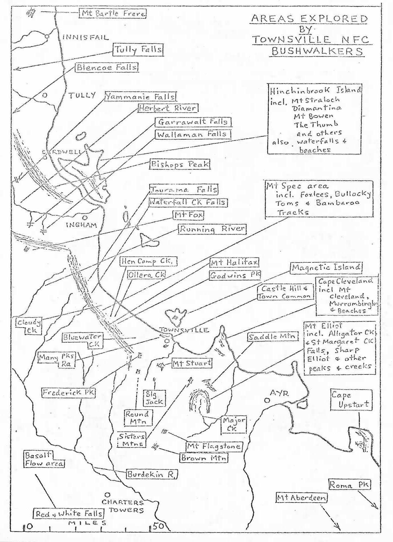
AREAS EXPLORED BY TOWNSVILLE NFC BUSHWALKERS
Locations & Features on the Map
Northern Region
- Mt Bartle Frere
- INNISFAIL
- Tully Falls
- Blencoe Falls
- TULLY
- Yammanie Falls
- Herbert River
- Garrawalt Falls
- Wallaman Falls
- CARDWELL
- Bishops Peak
- Jourama Falls
- Waterfall Ck Falls
- Mt Fox
- INGHAM
- Running River
Central Region
- Cloudy Ck
- Hen Camp Ck.
- Ollera Ck
- Bluewater Ck
- Many Pks Ra
- Frederick Pk
- TOWNSVILLE
- Mt Halifax
- Godwins Pk
- Castle Hill & Town Common
- Saddle Mtn
- Mt Stuart
- AYR
Southern Region
- Big Jack
- Round Mtn
- Sisters Mtns
- Basalt Flow area
- Burdekin R.
- Major Ck
- Mt Flagstone
- Brown Mtn
- CHARTERS TOWERS
- Red & White Falls
- Mt Aberdeen
- Roma Pk
Explored Area Details
Hinchinbrook Island: incl. Mt Straloch, Diamantina, Mt Bowen, The Thumb and others, also waterfalls & beaches.
- Mt Spec area: incl. Foxlees, Bullocky, Toms & Bambaroo Tracks.
- Magnetic Island
- Cape Cleveland: incl. Mt Cleveland, Murrumblingle & Beaches.
- Mt Elliot: incl. Alligator Ck & St Margaret Ck Falls, Sharp Elliot & other peaks & creeks.
- Cape Upstart
Map Scale
- Scale: 10 to 50 MILES
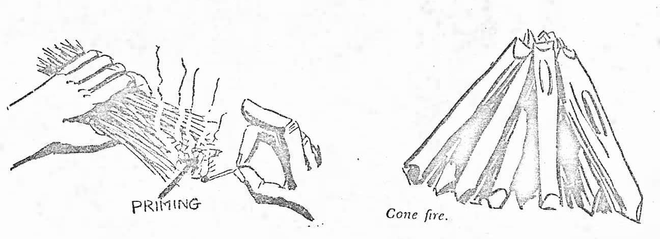
THE ART OF LIGHTING A FIRE
R.N.
- Always carry matches in waterproof container, e.g. screwtop can - one of the four cardinal rules of bushwalking.
- Gather firewood in graduated sizes. If wet, look under logs. Can cut slivers from inside large logs. Dead branches on trees are less wet than branches left on ground. Dry leaves are always found under the dome of the pandammus tree. For kindling, use thin dead twigs.
- Arrange twigs at first in a wigwan style or criss-cross style. Keep this small. Use paper or grass to ignite wigwam.
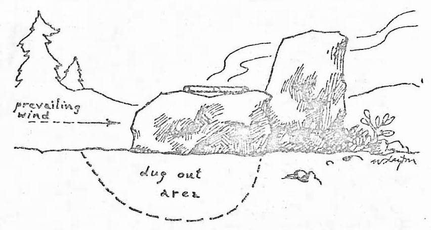
If in a valley, winds at night tend to go towards the sea. Face fire into wind to create updraft through wigwam.
- Gradually add increasing large diameter pieces of wood.
- Arrange large logs so that one feeds another with heat. A star shaped fire allows continuous burning. In a strong wind, pile the logs parallel to the prevailing wind.
A candle or Bic cigarette lighter is very useful.
TAKE CARE - BUSHFIRES CAN BE NIGHTMARES