Newsletter June 2019
June 2019 Townsville Bushwalking Club newsletter: upcoming hikes, meetings, and local track closures (Mt Elliot, Palm Creek, Paluma). Recent walks include Paradise Beach, Walkers Creek, Joy’s Cliff, Puzzle Goanna, and Bambaroo Track. Stay updated on bushwalks!
Next Events
Walk 23 June 2019 Sunday – leader TBA
Walk 29 Jun -1 Jul - 3 day long weekend – leader TBA
Walk 7 July 2019 Sunday – leader TBA
Monthly meeting 8 July Monday – VP and Sec to run (Prez away).
Membership
We have 25 current members. There were 9 who did not re-new membership.
Location Updates:
Mt Elliot national park walking tracks are closed until 5 July.
Palm /St Margaret’s Creek area track is closed until TBA – overgrown, they will not let anyone in until they clear the track.
Mt Spec Forestry Road – Paluma Dam access – closed until further notice, due to road damage.
Taravale access – roads still wet, overgrown, and not cleared yet.
Upcoming events
Bowen Lighthouse Walk (not a club event) Saturday 31st August. Might be worthwhile going to it. More info at this website:
https://www.tourismbowen.com.au/see-do/whats-on/walk-to-the-lighthouse
However, Keith is thinking of another day during August as a photographers outing, sunrise / sunset - good low tides all through August. Plus can do the Mother Beddock walking track whilst there for a spectacular short coast walk.
Maps
Paluma Mt Spec track network, you can download maps from website www.paluma.org. Good resource if you georef the maps and put on your phone / device for live gps mapping.
Mt Haliafx track is on the national parks website.
Happenings
What else is happening ?
If you would like more variety in your walks or can’t always make the club walks, consider going with the MeetUp Lets Walk Townsville group as well:
https://www.meetup.com/en-AU/LetsWalkTownsville/
Pelorus Island with NQUEC. Saturday 29 Jun – Monday 1 Jul.
Four members are off to do the Larapinta trail in the NT. But not content with that 220 km trek, the Ministry of Silly Ideas has added three extra off-track summits. So will be about 260 km trek in total. All looks ok on the maps – always does doesn’t it !
Joy wants more mountains to climb – so if you know any, let her know.
Recent Walks
Paradise Beach
A hardy small team of five assembled for Paradise Beach walk. The aim was to re-mark the route, as it has become overgrown and indistinct in last two years. A cracking pace down the beach, into the bush for the first saddle. Over the saddle, down into middle (Bray) beach, we used a new route on the flat to get to the beach. Smoko break at north end of Bray Beach, we were served scones with jam and fresh dollop cream, and savoury snacks, by Jo and Joy. This is the life.
Over the next saddle into Paradise Beach, reaching the beach at 11am. We found a shady spot and had an early lunch. Lunch was provided by Jo – gourmet sandwiches - Turkey and cranberry sauce on special bread – us males could get used to this.
On the way back the route marking started in earnest. We were slower coming back as route marking takes time. The new route on the flat from the AIMS saddle to Bray Beach is on the right side of the creek (old route was left side) – it is a straighter route and comes out on south side of the creek mouth. Afternoon tea was more scones, jam, cream and bikkies with cream dollops. Decadent.
A mix of route markers was used, metal plates and nylon tape, so the route will be easier to find and follow for some time now (need to paint the metal markers though).
We got back to the cars at 5 pm, a successful and productive day.
After having scones with jam and dollop cream, the decision was no ice creams on way home. But – would you believe – as we got into the cars, somebody weakened – so we all went for ice creams after all.
Thanks to the team for the route marking work, and the excellent catering. Now that has set a precedent of what us men expect on every walk now – catering with gourmet foods by the females !
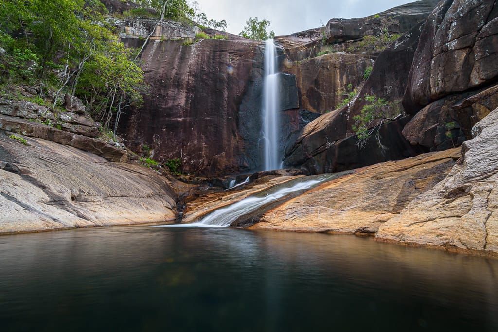
Walkers Creek
We had 10 – or was it 11, bushwalkers. Well, 11 at the start, until someone went to put their boots on – uh oh, no boots. So 10 started the walk, and the 11th hitched a lift home. Expecting long wet grass for the hour walk to the creek, it was a pleasant cleared track walk with no long grass and we were at the creek in 45 minutes. The creek had good flow, highest we have seen it for some time. We used the old route, by not going straight up the creek but follow the track and cut through direct to the first pool, an easy walk. From here it was the usual route rock hopping up the creek. Anneliese was the route leader, zooming ahead up the rocks. At 0910 at the first cascade “is it smoko time yet?”, I had to keep the mob moving – “No!”. Further on, at the usual waterfall pool, I let them stop for smoko. More clambering and rock hopping, the creek was very scenic with the increased flow, many cascades and nice pools. A large carpet python was found basking as we walked by it – well spotted by Joy. We got to the base of the main waterfall early, a great sight. The usual walk up the right side, some went bush, others up the challenging side rock face. After a nice break up top, we went down to the base of the waterfall for lunch. A perfect place to have lunch with a good waterfall as backdrop. Some tried swimming, gasps and cries was all I heard. After lunch it was all downstream, a nice walk, back to the cars, early again, at 3 pm. Plenty of time for extra ice creams then.
Joy’s Cliff
The things we must do to celebrate Joy’s birthday! After two years of nagging, we are having a go at Joy’s Cliff. Two years ago on top of Cockatoo Rock, silly me pointed out a large sheer cliff on the western side of Cockatoo valley. Joy said ‘right, when are going there?”. Ooops - uh oh.
Ever since, we have been nagged about going there. Finally, Wilfred and I have run out of excuses. An exploratory walk , we know the destination we seek – Joy’s Cliff at 650 mr elevation. But how to get there is the unknown. Weeks of studying maps and GE, we figure out some potential routes. But the rain of past few days and overnight, might make this even more challenging.
A team of six assembled at Mt Elliott Drive at 0630 – who chose this ungodly hour. Maybe me ? Short drive to end of Mt Panorama Drive, park cars, start hiking at 0640. Along a dirt road track, one complains of sticky muddy shoes. Enter Slippery Rocks Creek, rockhopping along the creek. As the creek climbs, rocks become larger, and the creek earns its name well – slippery rocks abound. After an hour, the creek becomes rougher and slipperier, we are at the base of the ridgeline we think will be a good route, so we leave the creek – a steep friable slippery scramble to start with. Vegetation is wet so our boots are wet. A very steep climb, over slippery rocks, then thick vegetation, and a lantana bash. It is overcast, while the temp is pleasant, it is very humid and sweat pours out of us – well me anyway. At 400 mr elevation the vegetation thins out, and the slope steepness lessens. Start to get some good views – west into Slippery Rocks gorge - high sheer cliffs, awesome sight – to the east and north, grand views to the coast. Strangely find five horses up here – how do they get here ? There must be an easier way, but the ridgeline has steep drop offs either side. We have morning tea here - pikelets with jam and dollops of real cream, and homemade bikkies.
Moving on, the team is disappointed when I say still 200 mr elevation up to go and another 1 km distance – “what? – you sure?” they ask. But the walk is relatively easy compared to earlier, until near the summit the vegetation thickens a lot, stunted short tough trees to bash through. “are we there yet?” I am asked often. “well, we are on top of the cliff line, 650 mr elevation, but to get decent view might be hard here with vegetation right to the cliff edge”. We find a small clear patch where we get bit of a view, but limited by loose rocks on the edge. Certainly not the view we seek. We decide to go to hill 750, about 1 km away, where there is another cliff line but with flat open space on top, which should provide good view looking back – we call it Yellow Cliff. A tough bush bash, whilst still on top of Joy’s cliff, we get to another point where we get very good view of sheer cliff. But no space to have a break. So keep moving towards Yellow Cliff. We run into paper wasps, the fastest you have ever seen people move. At 1215 we arrive somewhere near Yellow Cliff – we find an open spot with good views, and have lunch. Great views looking back to Joy’s Cliff. Mandatory climbing of a large boulder here.
1 pm - how do we get home from here ? We are closer to Cockatoo Creek now, but a 400 mr drop down to the creek – there is a ridgeline that runs all the way down, but getting to it may be fun. So we find a break in Yellow Cliff, and descend down that, very steep, many loose rocks, and sliding down granite slopes. Many stumbles along the way, but the girls were having fun, lots of giggles. Us men are more serious ! After an hour the steepness lessens, vegetation is nicer, and we cruise along down Cockatoo valley. At 3 pm we join Cockatoo Creek about 1.2 km upstream of the track junction. Afternoon tea – rich indulgent chocolate cake with dollop of cream, more bikkies, and a frozen ice block . Joy, Jo and Monika have catered very well – it is what us men now expect all the time. Albeit, think we gained weight today rather than lose any. Walk down the creek to the track, then to Alligator Creek day use area. From here we have to walk to Mt Panorama Drive, so exit the day use area along the road, into Slippery Rocks Creek and hike along the creek to the end of the house line, then a short walk to the cars, arriving 5:15 pm.
That was a long circuit walk, but a great one.
On the way home – the ice cream stop – we drove by, no ice cream today (too much cake and cream during the walk, plus it is late (but I have ice cream at home anyway)).
Huge thanks to Wilfred for leading.
What do we do for Joy’s birthday next year ? (Note - I am busy that day).
14.3 km
Ascent 794, Descent 803
Max elevation 674
Start 6:40 am Finish 5:15 pm
Future reference :
Walk is suitable for small group of experienced bush walkers only. Max 6.
Need to carry water for most of the day – no water resupply away from Slippery Rocks and Cockatoo creeks.
Suggest park one car in the Alligator Creek day use area for car shuttle, removes the last hour of unnecessary walking.
Early start recommended.
Slippery Rocks Creek gorge may be worth exploring – but dry conditions only. But need to do early in season if you want flowing cascades as probably dries up mid to late year. Rocks are slippery though.
Puzzle Goanna
The May long weekend, was a three day hike in the Puzzle Creek – Thunderbolt Creek - Goanna Creek area.
Saturday - Started from upper Puzzle Creek falls, which had very good flow. Usual hike along the creek, down to Cable Pool for lunch. High water levels made for some challenges. Tried to keep the group moving, as my planned lunch spot and potential base camp spot was ten minutes away, but they refused to move. I had a plan to camp first night at Communist Cave on Thunderbolt Creek, then second night on Puzzle near Puzzle Falls, but Wilfred suggested base camp in Puzzle somewhere. So base camp it was. After lunch we went downstream to Honeymoon pool, ten minutes away, and that was base camp. A lovely spot. After setting up camp, at 3 pm, not wanting the others to get bored, I drag them off for a 2-3 hr return walk down to Puzzle Falls. (there was some questions of “why?”). There were some challenges along the way due to high water levels. Puzzle Falls had very good flow and looked great. It was late in the day, but we zoomed back upstream to camp in time for a late afternoon swim (yes, the water was bit chilly).
Sunday – a day hike overland to Goanna Mine. With Wilfred leading and me navigating (usual setup), we set off overland for Thunderbolt Creek. Open woodland country so easy going, some hills to cross. Above Thunderbolt, a steep descent to the creek. We arrive at Communist Cave, I proudly show the others my planned camp site - they were horrified ! What is wrong with uneven ground, long grass, lumpy bits ? And they were not impressed with the water in Thunderbolt – looks alright to me though ! Anyway, apparently I have been sacked as camp site planner (I will exact my revenge one day though). We explored Communist Cave, and had morning tea. Now to find the art gallery, which I did not have GPS reference for, so went off memory. After searching for a short time, we found it. A few aboriginals stencils, faint, but still visible. Now head off to find Goanna mine, but first the tractor on the hill. An easy cross country hike, many hill tops around, one of them has the tractor on it. We go direct to it, good navigating I reckon J
After exploring the tractor, and discussing how much work to get it going, we move off to find Goanna Mine. Short time later we arrive, and explore here. Now time to find a lunch spot down in the creek near the old homestead. Downhill we go, find the old mine processing plant and old vehicles, look around here. Then to the creek and have lunch next to small pools. Then to find the old homestead, this will be easy – right? Apparently not. We spread out and look around, but no old house. There is a lot of re-growth in the area now, making searching harder. Getting frustrated, where the hell is it? After some time, Rosemary spies in the distance something unnatural – a rock wall. Go up there and there is the old house – well done Rosemary.
Now if we had camped at my ‘nice’ planned site at Thunderbolt Creek, we would have a shorter walk to camp. But no, we have to get back to Puzzle, a long walk. So head back to Communist Cave, then downstream Thunderbolt for some time. We are looking for a less steep climb out of Thunderbolt, but it is all steep. Eventually, it is getting late, we decide we need to climb out of Thunderbolt and head direct overland to Puzzle. A steep climb, at the top we have a rest. “don’t sit down there Jo, there is a snake there” ….”what?”…. “Jo, come here!!” … “what?”…. we look, what snake ? But there, camouflaged, is a death adder, that Jo was about to sit on. OH !!! Maybe we will not have a break here ! At top of the range, it is now an easy walk back to camp. That night was good sunset, clear skies, and bit chilly. There was strict enforcement of the 8 pm camp rule.
Monday – we plan to get back to upper Puzzle falls by noon, and the cars by 2pm. We set a good pace and made good progress. Nearing the falls, Rosemary decided to have an impromptu swim whilst jumping a rock gap (or did Wilfred push her in?), so all her gear was wet. Lunch at base of the falls, a grand sight with good flow. Then the short walk to the cars, arriving 2 pm, dead on time.
Bambaroo Track 9 June
The weather forecast was not good for the weekend, so we decided to avoid creeks and do the Bambaroo Track. A nice forest stroll all on track. We called it Katherine’s Revenge – her final walk – as she loves uphills, especially first thing in the morning (not). And she was not allowed to take her hiking poles. At 8:18 am we started the hike, immediately onto the uphill steep road to warm up – 272 mr elevation, 1.9 km, 30 minutes. That got us all hot and sweaty. Then onto forest bush walking track, short while later arrived at the fig tree area, an amazing place. Visited the giant strangler fig tree that we usually go to. Announced that the Bambaroo virgins must climb the tree, or we are cursed. After strange looks and “are you sure?”, they did climb it. We then continued uphill, passing through the buttress tree area, another area of amazing trees. The area was heavily eroded from the wet season. Further along, we find wait-a-while vines on the track, so that slowed us down as we cleared our way through. 10 am, we stop at another giant fig tree for a break.
We continued climbing uphill, constantly slowed down by wait-a-while vine. More steep climbing, then through the grass tree area. We started to get a few leeches now too. Nearing the top, we descended down through the saddle, then up to the water point, for lunch. It looked like raining, and was misty. Leeches were hungry here so we fed them. We thought about going up to Garde’s Lookout, but with the mist around decided not to. Plus, it was getting a bit chilly.
On the return leg, with the track cleared we zoomed downhill. Back to the fig tree area, we turned right to see a giant fig tree that some of us had not seen before – it was magnificent. We had afternoon tea. No scones, jam and cream or chocolate cake this week from the ladies – why not ? After a nice break, we headed downhill on the home stretch. Back at the cars at 4 pm. Then off to Frosty Mango for well deserved ice creams, and to compare how many leech bites we all had.
Stats – 14.8 km, max elevation 755 mr. Total ascent 923 mr.


