TNFC Newsletter - November 1979
Discover the Townsville Bushwalking Club’s November 1979 newsletter—featuring epic treks to Bartle Frere, Porcupine Gorge, Hinchinbrook, and the Herbert River. Packed with trip reports, safety tips, club news, and upcoming walks, it’s a glimpse into North Queensland’s rich bushwalking history.
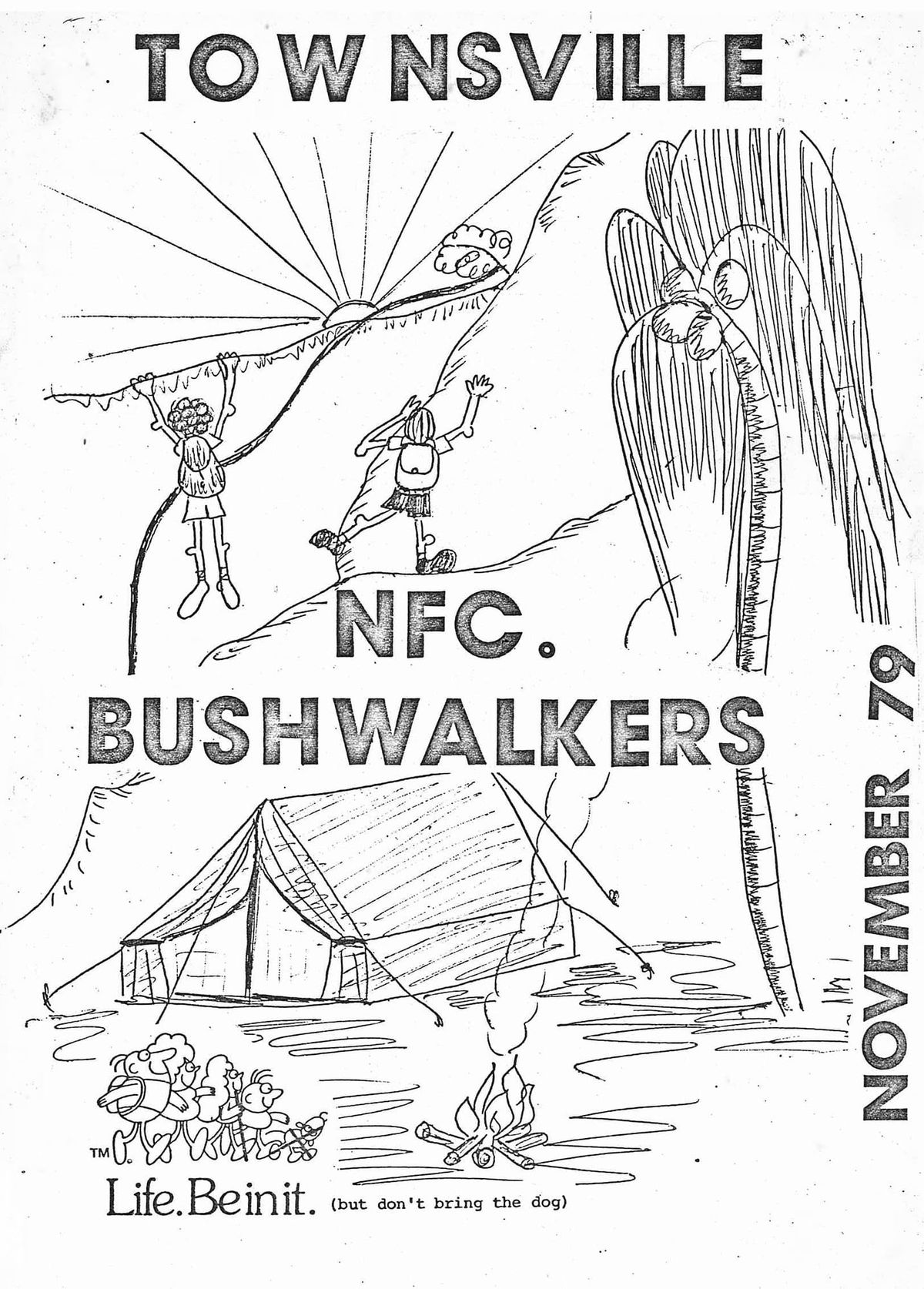
TOWNSVILLE NATIONAL FITNESS BUSHWALKERS CLUB.
P.O. Box 494, Townsville, Qld. 4810.
HON. OFFICERS
PRESIDENT Alan Watson
VICE PRESIDENT Roy Williams
SECRETARY Les Hyland
TREASURER Pauline Roberts
EQUIPMENT OFFICER Bill Dunstan
SAFETY TRAINING OFFICER Jim Cameron
EDITOR Chris Wright
ASSISTANT EDITOR Ron Ninnis
CONTACTS
Karmen Nisbet Adrian Jeffreys
10 Nobel Street, Townsville Environment Centre
University Heights. Townsville. 4810.
Q. 4811 ph. 71 6226
ph. 78 1935
MEETING PLACE
The National Fitness Office,
Cleveland Terrace (side entrance)
Opposite the old Supreme Court.
(until further notice)
EDITORIAL
Welcome to the '79 Christmas issue of the Townsville Bushwalker's Magazine. I hope that you will enjoy the articles, snippets of information and history that lie within these few pages. We even have a serial for you to enjoy.
My special thanks goes to the assistant editor Ron Ninnis whose help with this magazine has been enormously appreciated.
Don't forget the club picnic on the 8th and 9th of December, at Running River! In the meantime:
KEEP ON BUSHWALKING!
C.W.
SOCIAL EVENTS OF THE YEAR
- Lynn Murray is now a Highlander! On May 19, she and that indomitable leprechaun Les Hyland married.
They have now shifted house to 82 Cook St. They say that the house came complete with green paint, and BBQ. The BBQ sounds promising for more Bushies BBQ's. - As a result of bushwalking trips - Porcupine and Herbert - Chris (Smith) and Darryl Wright are now married. Must be something about the names Porcupine and Herbert.... Do they sound romantic to you? On the 18th August, they were married in the idyllic setting of Mt. Elliot National Park. Bushies celebrated in typical style by a bring-your-own cuppa, burnt BBQ sausages, and by numerous toastings to Darryl and Chris, the King and Queen, and everyone else.
- A suprise 21st Birthday Party was held for Bob Ferguson in July. He did not get there and when he found out about it the next day, he was really suprised. He had spent the evening looking for his friendly bushwalkers, who also spent the evening looking for him! The rest of us enjoyed the party....
- For those that don't know, Harry is a sprightly 70, and hails from Lancashire. Jill is slightly younger, and also sprightly. Harry's enthusiasm and love of life and nature here, inspired the Bushwalkers to greater heights (and depths). On May 20, to celebrate Harry's 70th Birthday, the club conducted a walk to North Creek, one of Harry's favourite creeks. A suprise BBQ was organised at the end of the walk, to begin at 4pm (1600 hours to Les!). After such a short walk, numerous delay tactics were employed by all to delay Harry reaching the BBQ area before 4 o'clock. Karmen helped the delay by inadvertently spraining her ankle. At the BBQ, Harry was taken completely by suprise - in fact he was speechless! The club bestowed on Harry Life Membership.
- Mary Roche was 21 on the 4th November. Many happy returns Mary....
ON THE TIP OF QUEENSLAND - MT. BARTLE FRERE
11th and 12th August 1979. Leader - BOB FERGUSON.
We left Townsville on Friday night to camp at Josephine Falls picnic area, (the turnoff to the falls is approximately 20km North of Innisfail, 2km before Mirriwini), arriving there at 11.30pm.
We rose at 7am and by 8 o'clock we had taken care of breakfast and we washed it down with a cup of tea. When we were almost ready to go, the rest of the party arrived from Cairns, making a total of eleven - eight from Townsville and three from Cairns. We headed off to the start of the track, (by returning to the last sign to the falls, turning right, crossing the creek, taking the first driveway to the right, and continuing to Paul Fanti's house. The visitor's book is seen on the left).
While some members were completing packing, the rest of the group were admiring the glorious view of Bartle Frere. and Broken Nose.
There wasn't a cloud to be seen. Someone said 'It doesn't look all that high.' Famous last words!
Waving goodbye to Paul Fanti we set off at 8.45am following an unused forestry track. The track was lined with raspberry vines and wait-a-while, and LEECHES! But, the leeches were not as numerous as we had been led to believe. After crossing the Russel River, the track followed along the top of a razorback and we stopped here for smoko.
Soon we were walking again and came upon a cleared area beside the river. We continued on up the ridge, and were suprised by a view of Broken Nose! On we continued up the ridge. It was now getting on to lunch time and we realised that something was amiss - we had mislaid the track, which is clearly defined by machete chops on every tree.
Bob climbed a large boulder to see where we were. We then realised that we had taken the track to Broken Nose and were on the wrong side!
We should have crossed the creek at the first clearing. But, all was not lost, we dropped down onto a saddle and climbed another ridge to join the track. Being 2.45, some members were a little hungry, so we sat down to lunch. A short time after we were on the track again, and in all we had lost about an hour. The good thing was that the right track was not as steep as the track we had been following. The weather was still fine as we pushed on up to the saddle and saw the campsite as there was not enough daylight left to make a walk to the summit.
A billy of tea was first order and was quickly done on portable stoves to conserve firewood for the cold night ahead. The sky was full of stars and we could see the lights of Malanda and Ravenshoe. The numerous farmhouses looked as if they were a reflection of the night sky. The campfire was a good mixture of stories and laughter, with rum being offered with the final cup of coffee (this went down well). The morning was cold and a few members went up to witness the sunrise and reported clear views looking North and East. With the camp- site behind us at 8am, we left our packs at the saddle to climb to the top, taking care when following the arrows across the boulders. At the summit we could see as far as the eye could see in every direction. To be at 1622 metres above sea level we felt as if we had really achieved something. In one direction, Bellenden Ker, to the other end of the range was Trinity Inlet. We could also see Atherton, Evelyn Tablelands, Russel River, multitudes of canefarms around Innisfail and Babinda, not to mention numerous islands. We left the summit with many photographs and memories.
The descent posed no problems. We lunched at the creek cross- ing and then continued down to the cars at 4.15. We arrived back in Townsville at 9.00pm feeling weary but happy.
Jim Cameron.
T'VILLE WALKERS HAVE LOST FRED'S PEAK,
AND DON'T KNOW WHERE TO FIND HIM,
LEAVE HIM ALONE,
AND HE'LL COME HOME,
DRAGGING THE NEXT PEAK BEHIND HIM?
(apologies to 'Mother Goose')
From our ARCHIVES...
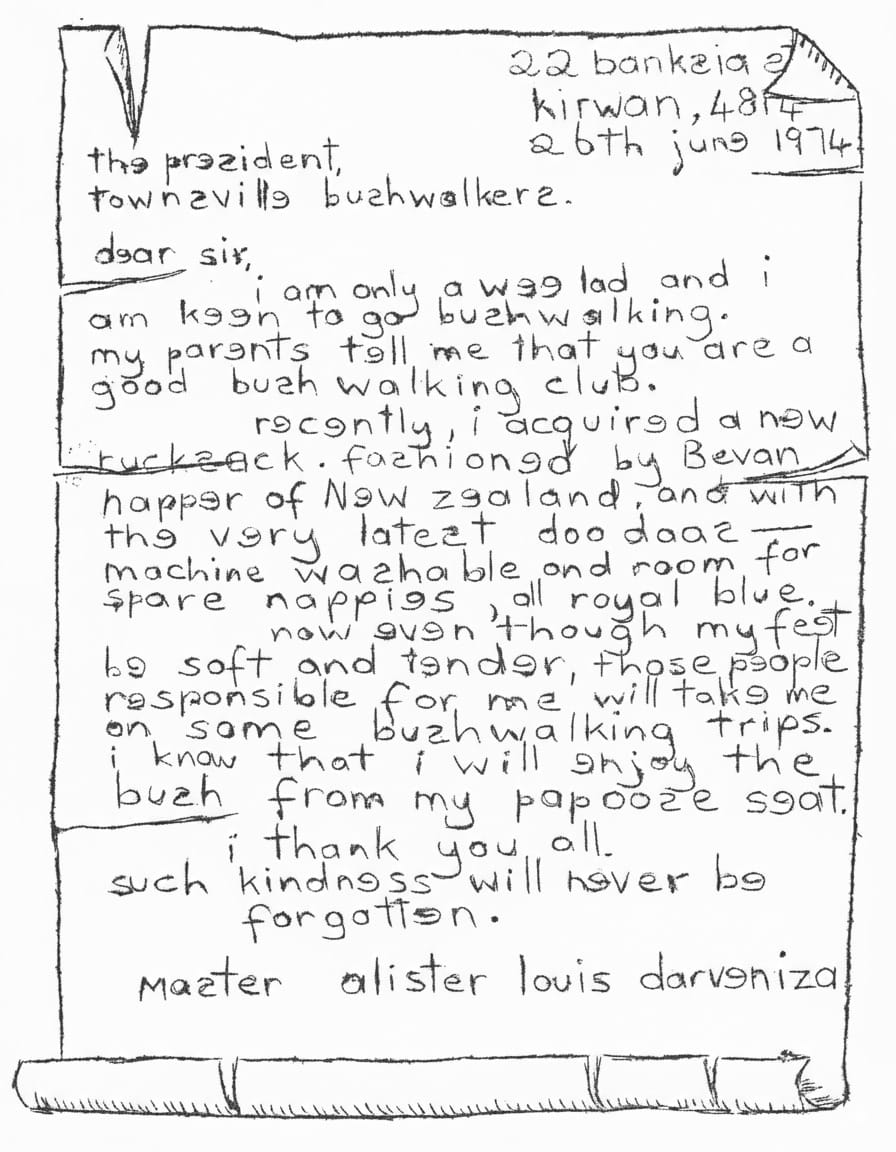
22 bankzia
kirwan, 4814
26th june 1974
the prezident,
townsville bushwalkers.
dear sir,
i am only a wee lad and i am keen to go bushwalking.
my parents tell me that you are a good bush walking club.
recently, i acquired a new rucksack. fashioned by Bevan happer of New zealand, and with the very latest doo daaz — machine washable and room for spare nappies all royal blue.
now even though my feet be soft and tender, those people responsible for me will take me on some bushwalking trips.
i know that i will enjoy the bush from my papooze seat.
i thank you all. such kindness will never be forgotten.
Master alister louis darveniza
THE GLORY OF THE CREEKS.
Mt. Elliot does not appear to merit its near 4000 feet, and, on closer inspection, its convex projection considerably fore-shortens its image of an outstanding peak. After topping its rocky summit with the Club (29-6-75) I was impressed by the upper reaches of the creek running Northwards from near Mt. Elliot's highest contours. I subsequently began to investigate the possibility of better routes than the bush-clad ridges. Alan had already tried Palm Creek. I confined myself to two creeks whose sources approach the summit. To distinguish one from the other I gave them the non-obligatory names of North Creek and North-West Creek (Cockatoo Creek). On both, my findings of advantages or otherwise were unanimous, the advantages were predominant, as my following appendages will bear out.
N.B. I have no measuring instruments, so distances are only approximate, from memory only. Times are taken from Alligator Creek Picnic area and Car Park, easy walking 2-3km per hour, undertaken under dry conditions.
Advantages: 1. Much more scenic - waterfalls - longer and wider vision, especially from escarpments. 2. More variety of scenery. 3. Ever -present fresh water. 4. Many ideal picnic places, with dry firewood. 5. Heavy protective clothing is not essential - diverges into the bush are minimal, and no machete is needed. 6 With longer vision, parties cannot lose one another - every member will be somewhere along the creek bed. 7. Because of the terrain, no compass or map is necessary. 8. Shelter, in showery weather, under overhanging rocks. 9. Small scrambles give more balanced exercise and add interest. 10. Better chance to observe fauna. 11. Fine exercise of double - roping, if wanted. 12. No 'false' summits.
Disadvantages: 1. Perhaps slower, with a party unused to scrambling. 2. A rope should be taken, especially for beginners. 3. No 360° views. 4. Impossible after heavy rain.
NORTH CREEK
After passing Old Farm (1 hour) on Alligator Creek, follow line of pylons. The first creek is dry, the second our objective. Then 2km of 'round stones', criss-crossing the water as desirable. (The Long Pool, at start, may be avoided by a path on the left for a few metres). At First Picnic (1½ hours) are pools around 4m in diameter. The route steepens, through large granite boulders, to Second Picnic (2 hours) where an intrusion of basaltic rock gives us a waterfall of 20m and larger, deeper pools. Then comes a delightful stretch of 40m, rock scrambling up intrusions, and sometimes tricky negotiations of great granite bosses that form the stream bed. It is even necessary to pass into a short stretch of the side foliage to avoid an impasse. Here also are large deep pools (up to 20m diameter) in which are many marron (crayfish), and, on my initial trip the air was thick with brown-and-white butterflies. Sometimes I have even seen the great blue butterfly (Ulyses) and the large, velvety black one. Then comes the big tree (3 hours), that slopes at a steep angle up the creek bed. It is possible to walk or shuffle up the tree, but there is an alternative route, left, around the immense boulder. From here it is an easy half-hour to the Last Intrusion (3½ hours), the junction with the previously mentioned Mt. Elliot expedition. The angle eases and it is simple to walk up the creek, then strike up to the summit by the right bank at any vantage point (4½ hours). Descent is by the same route, though, for interest, seek the opposite bank to ascent. Going down is slightly quicker (about 25%), for, big 'steps', impossible to ascend, may be slid down, though continous 'rear-end' sliding may be somewhat abrasive to the skin' with care, this is a most enjoyable trip — those who aspire to achievement can crown the summit of Mt. Elliot without much bush-bashing, and those less ambitious, can laze, sunbathe or swim in the crystal clear waters of North Creek.
NORTH-WEST CREEK (Cockatoo)
From the car park follow Alligator Creek, and, 1km from Turnstile gate come to the first 'wet' creek. This is North-West Creek (1/2 hour). Then follows 3km of 'round stone' walking, (usual to see turkeys here), when creek (now dry) turns S.E. then S. The walls constrict and we arrive at Picnic Slab, (2 hours), with precipitous side wall, festooneed with the rope-roots of rain forest. Steeper now, through large granite boulders to the Rock Fall (2 1/2 hours), a recent collapse of the right wall. Then the Root Traverse, along the left side, where a short climb averts the impossible. Next, I 'burn to tell you' of Green Ant Traverse (3 hours) beside its chattering waterfall, as we come into the big trees - the Octopus with its roots sprawled out over a large rock. Double Bridge - walking the narrow one requires a good balance. Victoria Bridge, a graceful span, which she would be very amused to cross, and, finally, as our noble stream becomes an insignificant trickle to Barton Bridge (5 hours) where one huge log crosses the other. Somewhere up the left bank is the to of Mt. Elliot, but, on seeing the dense rain forest I decided to leave that finish to more aspiring people than I.
In compiling these notes, I hope they will be of use in acting as a rough guide, and help in the appreciation of the lovely country around Townsville.
Harry Kershaw.
The Further Adventures of Harry and Jill...
Harry and Jill were last seen heading towards the Herbert on a mapping
excercise lasting 4 weeks.
Have you heard about a certain Bill Dunstan who jumped into an
old bunker on the 'Kangaroo 3' exercise? On turning around, he noticed
a taipan staring him in the face, so he made a gigantic leap to the
surface again.
Who holds the record for broken Kayak paddles?
Ron broke 3 paddles in 2 months in paddling the North Johnstone and
Tully Rivers. Can anyone better this?
John Riley and H and J spent 4 lazy weeks sailing around the
Whitsunday Islands to the Cumberlands. H & J remarked that while John was
a great yatchsman, he had a predilection for lee shores.
Harry claims he has discovered the longest slippery slide in
Qld. It is on the Mt. Diamantina side of Hinchinbrook Island and is
2000' long. Any takers?
BUSHWALKER'S HONEYMOON
Dec 78 - Jan 79.
The idyllic dream of a Tropic Island with white sands and the trade winds caressing the palms is probably everyones idea of a honeymoon setting. Since so many of the bushwalkers knew that our intention was to cruise the Whitsunday Islands in fulfilment of this dream, members may be interested to know 'what is the substance that all those dreams are made of' (no apologies to Hollywood).
With the wedding behind, Lee and I got down to the business of loading supplies, wading knee deep in stern bearing grease, sump oil and other romantic activities. After one day delay, we departed Seaforth Creek in our 33ft Cutter, 'White Ibis'. We headed North through Port Neury, past two abrupt green hills called simply the High Islands, then to the East; course set for Repulse Islands.
We arrived at noon in perfect weather to find anchorage on South Repulse dotted with plastic power boats and plastic sailboats, (we found out subsequently that a tent city of some forty people from Calen had taken up the island for the vacation period). Not to be put off by the crowds we anchored to the North of the residents in two fathoms and went ashore to walk around the island. The surface volcanic sediments are heavily weathered, giving the island a grotesque 'Moonscape' beachline. Goats have been introduced from East Repulse Island since my first visit which was in the early sixties and the damage and erosion that only goats can cause is very apparent.
Flotsam on the tide mark was interesting and included several left footed thongs, a Japanese fishing bouy and a can of smoked sausages that went down well for tea. Three hairy bearded faces confronted us near a gully on the beach. They were not the local beachcombers but three of the island's complement of goats. I neglected to mention that the other members of the crew were a belligerent Blue Mountain Parrot called Willie, just in case, and my dog Sheba. At the sight of the intruders, Sheba flew to the chase and goats bounded in all directions. I have never given my dog credit for being able to catch anything more than a cold, but for one small pregnant nanny who took the path to the sea, luck had run out! Sheba baled the goat up on the oyster encrusted volcanics and would have 'done it in' had I not come to its rescue. I make a mental note for future reference when the larder is not so full.
We spent a pleasant night aboard. At dawn, on flat seas but with a tide rip we headed the boat for Kennedy Sound, the loch of water between Lindeman and Shaw Islands. Landing at a narrow neck we crossed the island to the ocean side and walked some distance around the rocky bluffs.
At the beach, coconuts had been planted along with dates and hardy tropical fruits. A field of sisal was also doing quite well. Lee almost trod on a Death Adder; this rather sullied the idea of tripping around the islands, unless your weather eye is to the ground and you have good foot protection.
An enjoyable few days were spent exploring bays and inlets, collecting left footed thongs and Japanese fishing bouys. A notable exception was the transistor radio that came floating past on a lump of driftwood! We presume it was left on the beach by a Lindeman tourist and subsequently floated off on the king tide. It continues to play today as it did when - with much merriment - we turned it on in Kennedy Sound.
The fourth day found us on Thomas Island. Until now the weather had been hot and calm. Coastal storms were now forecast and on Saturday night at 2200 hours we had our first introduction to a tropical squall. A black cloud had been building up in the South and on the dot of the hour descended with a fury. White caps tore from the waves and the island a hundred yards away was blacked out. The anchorage we had chosen for the night was open to the South and the squall drove in upon us. By guess and little else I suspected that our one anchor was dragging. As a precaution I crawled forward into horizontal rain and by the light of lightening flashes dumped overboard a heavier anchor. The storm soon passed.
At dawn we saw by our position that the second anchor had indeed checked out drift. The low tide which coincided with first light of left us barely six inches over clean coral sand!
The wind rose that day and after some consideration we turned back from entering the passage to Goldsmith Island. I had also become concerned at a ticking noise that arose in the marine gear bow on the previous day and we turned back to a sheltered bay on the North side of Thomas Island. A few hours were spent attempting to rig a sail - although the boat is a sailing auxiliary it has yet to be rigged. The sail could not be set due to the strength of the wind. Passage to the Newry Islands was to be via the Anchor Islands group. With a mast rigged Latine fashion - just in case - we set off at noon, the wind was still rising and the seas starting to break. The passage was five hours, very wet but quite exciting.
New Years Eve was spent in the anchorage at Port Newry in company with another yachtsman and his family. The boat's drifting was not yet over; late that night I was awoken by a brilliant flashing of light which shot through the portholes in spasmodic jabs. I flew on deck to find that we were once more adrift, had narrowly missed a motor cruiser, and were headed to a line of surf and rocks. Luckily the owner of the motor cruiser spotted us and had tried to gain our attention with his search light. After an hour or two and much sweating we were back in place, and turned in exhausted.
Morning found the wind still blowing. Four of the cruising yachts from Mackay came in from Goldsmith under trawler escort and the anchorage became quite crowded.
So, we set out for home, content to beach the boat in a cutting and get a bit of rest, No, it was not all over! On the falling tide a passer by called out that we had lost one blade of our three blade propeller. We had indeed! The ticking noise that I could not identify in the Cumberlands was the distorted blade striking the rudder post and we had come home thirty miles in rough seas with one third of our propeller missing and at a speed drop of only two knots.
We will long remember our honeymoon trip - in fact our first cruise - albeit under power. Next time we will know a bit more and will be better equipped. We even lost our film record! To sum up I quote Marion D. "The best outings, the ones you remember, are the ones you spent wet, cold and miserable".
Rick Williams.
ON BEING 'PRIMITIVE'
Is all the gear we lumber around on our backs really necessary?
The aboriginee never used to indulge in such restriction. However, being accustomed to our modern comforts it seems that we cannot become primitive overnight. The gradual reversion to the primitive state is a skilful art - a strong path of suffering and set backs full of challenges and rewards. Fruition may take years.
The feet, for instance. The local practice of 'going without' is spreading. Nothing so simple as developing a corny layer; balance is involved, accurate placement, short steps, methods of lowering the foot.
It is a lifetime study.
The common eating implements can easily be dispensed with - knife, fork and spoon - the bush is full of sticks, but to wield them dextrously?
It goes without saying, of course, that a towel, comb, soap, change of clothes, plate and toothpaste are quite superflous. Antiseptic for wounds - what better cleaning agent than blood pouring from within?
But, I am depressing. This is obvious. There is no skill in this.
The next logical step is to the question the value of sleeping bags and ground sheets. What is life without suffering? The obvious substitute is fire. Investigations into this matter are still in the infant stage.
And so it goes on: fire without paper and matches, no sweater, no tent, no hat, more living off the land. At each step skill and suffering become more pitted against each other.
The reversion to the 'Primitive State'; just how far should one go? Where does sanity end? There must be no bludging on others, no jeopardising of safety, no slowing the progress of the party, no sacrifice of the other people's enjoyment.
Behind these daunting reservations - a new skill - an art of profound depth.
Peter Reimann.
NOTICE
HAS ANYONE FOUND
LOST JIM
LATELY?
Reward Offered.
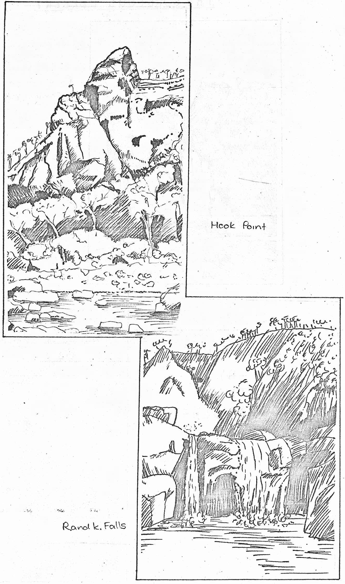
PORCUPINE GORGE
This three day trip was held on the 5 - 7th of May with Lily Marcellos as trip leader. We left Townsville on Friday evening and spent the night at Warrigal Creek, just before the Burra Range. In the morning we drove into Hughenden where we had breakfast and then proceeded North to Porcupine Gorge.
It was planned to meet Harry and Jill at the top of the Gorge where we parked the cars, and from there it was a fairly easy downhill walk to the pyramid where the base camp would be set up. My first view of the pyramid just about took my breath away, it was truly as magnificent as I had been told it was. There was a reasonable sized pool in front of it and this was where we set up camp just before lunch.
In the afternoon we went for a hike downstream and found many interesting and very colourful rock formations which were formed by water erosion. There were also a few beautiful groves of Casurinas (She-Oaks) but after the water dwindled and the countryside ahead looked as if it was going to remain the same for some distance, we turned back. Swimming in the pool at base camp was extremely pleasurable and there was even provision for the more adventurous of the party to dive into the pool (it was quite deep) from a rock wall which formed the other bank.
That night the camp was made more pleasurable by Jess with her 'skin of red' and the entertainment was provided by Bob and his demonstration of how to dry (or how not to dry) wet shorts over the fire, a feat otherwise known as how to make sure that your shorts are completely well done.
In the morning a day trip was planned upstream. Steeply sloped banks and interesting rocks, mostly sedimentary, made the Gorge quite beautiful. We pushed on a considerable distance, always heading for that next landmark, when we finally reached an icy cold swimming pool. From this pool a couple of nice Black Bream were landed and they made a tasty lunch until I discovered some sort of parasitic nematode worm nestled in the flesh. No-one else would touch it then and as I finished it (picking out the worms I could find), Lily voiced some concern for my well-being. After we had rested, though, we returned uneventfully to our base camp for tea.
On Monday morning we packed and had some fun paddling around the pool in a boat improvised from a forty-four gallon drum which Bob and Darryl had refloated from the bottom of the pool. The climb back up the side of the Gorge proved to be a bit harder than the descent, but we arrived in Hughenden for lunch and hit Townsville just as the sun was setting.
C.W.
Here we have Part 1 of a two part serial on the Herbert River. Part 2 will be in the next issue of this magazine.....
GORGEOUS HERBERT
When does a dedication become an obsession? Perhaps, as some people think, when it borders on lunacy. A fine line, and very debatable. I was first introduced to the upper Herbert River by my friend, Les - "There are some gorges further up, past the top of the road", and whilst he supervised the Slalom Canoe Championships at Coldwater, I, mapless and ignorant of the distance involved, fondly imagined I could reach the promised land. I did not of course, but I did fall under the spell of the lovely river, and looked far up into the mountains from whence it came. Another seed germinated, of which I wrote in a previous newsletter - why not use a kayak for a faster descent? Two years were to elapse before J. and I pulled and pushed a Canadian past Yamanie and the Bends to where we imagined Smoko Creek entered the main river.
This year we carried a fortnight's supply of food, and left caches at upstream camps to feed us on our return. Another change of plan - we would not make long day journeys, but would travel only for a few hours around noon, eliminating the necessity of a days rest, as in our '77 venture. This system worked well, and although the weather broke, we made two walking divergences, one, up Sword Creek, which proved rather flat and uninteresting, and the other up splendid Yamanie Creek to the magnificent Falls, which we had not seen before.
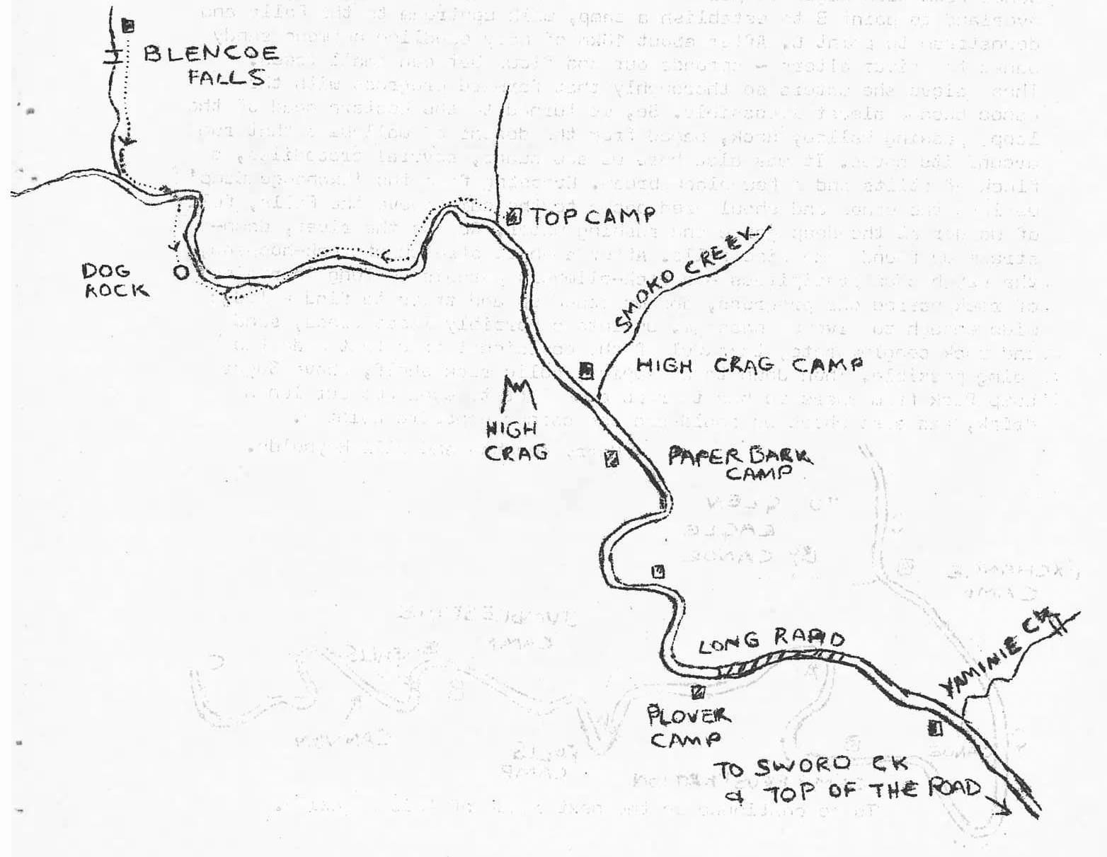
Onwards, making camp every few miles, until we came to the highest point of our previous expedition, only to find our surmise of Smoko Creek fell half a mile short, and that this water was only a secondary lead from the parent river. Now, into the unknown; the wide valley gradually closed in as we established Top Camp, a lovely place, where a small stream trickled through a casurina dell to join the placid lagoon of the river. Our supplies were running short, and J. even began to dream of food, and we should have had to take another hitch in the belt if J. had not thrown in a line and landed three black bream in twenty minutes. These helped considerably in our final walk up the river. First, the usual round stone walk and then we entered the gorge proper, with deep, green pools in glaring pinky rock, and some difficulty of terrain where the granite walls skirted the water. But we revelled in this glorious country, and walked on to a good landmark - a big rock, that resembles a dogs head, which we calculated to be 38km from the top of the road and only 4km from where Blencoe Creek joins the Herbert. We were thrilled to be so near, and J. obviously bitten deeply by the Herbert 'bug', said, "Why not make it the 'Year of the Herbert' and finish the whole gorge?" What could I do but enthusiastically assent, and so began the planning to complete the exploration of the 80km of the whole system - from top of the road to the Herbert Falls.
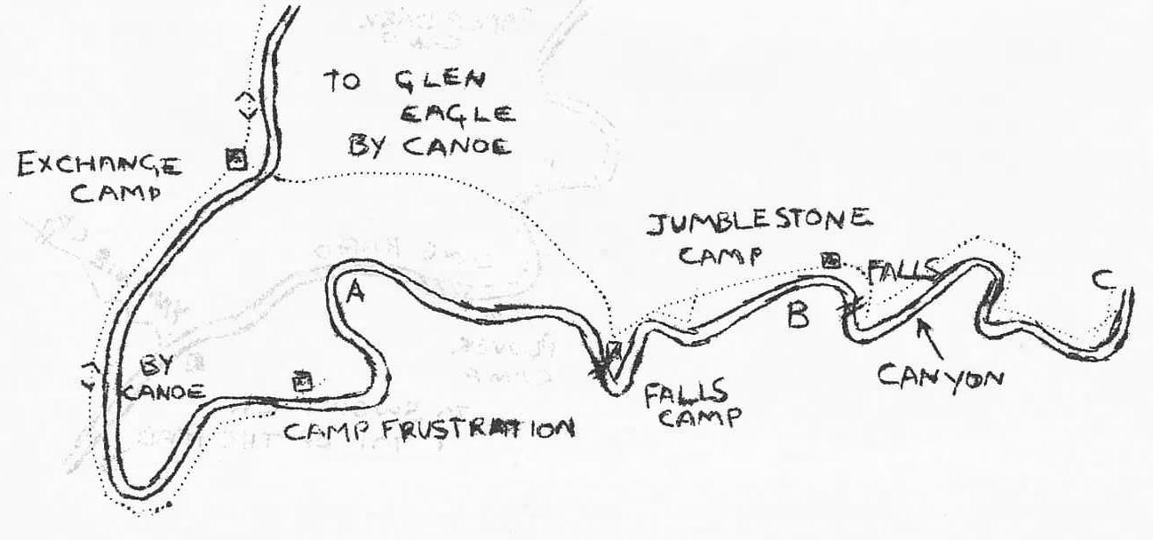
We had drooled over the Club's slides, maps and descriptions of the river at the Herbert Falls, so decided to do that section first. Canoe from Glen Eagle to point A - at the head of southward loop, then overland to point B to establish a camp, walk upstream to the Falls and downstream to point C. After about 18km of easy paddling between sandy banks the river alters - spreads out and flows between small trees. These sieve the waters so thoroughly that forward progress with the canoe became almost impossible. So, we turned to the Western head of the loop, passing Wallaby Rock, named from the dozens of wallabies that run around its caves. It was also here we saw swans, several crocodiles, a flock of stilts and a few black bream. Crossing from the 'Exchange Camp' we left the canoe and shouldered packs to the camp above the Falls, full of wonder at the deep gorge and rushing water. Across the river, downstream we found some fine falls. After a short stretch of rock-hopping, the way became precipitous - a rock-climbers paradise - long 'curtains' of rock barred our progress, and we roped up and tried to find a ledge wide enough to give us passage. Up into a horribly loose grass, sand and rock conglomerate, thankful of the occasional tree that made the going possible. Then down to a happier, solid rock shelf, above Sugar Lump Rock from where we had to rope down 50ft to even get our lunch drink, and also where we could see the corner opposite point B.
Harry Kershaw and Jill Reynolds.
To be continued in the next issue of this magazine.
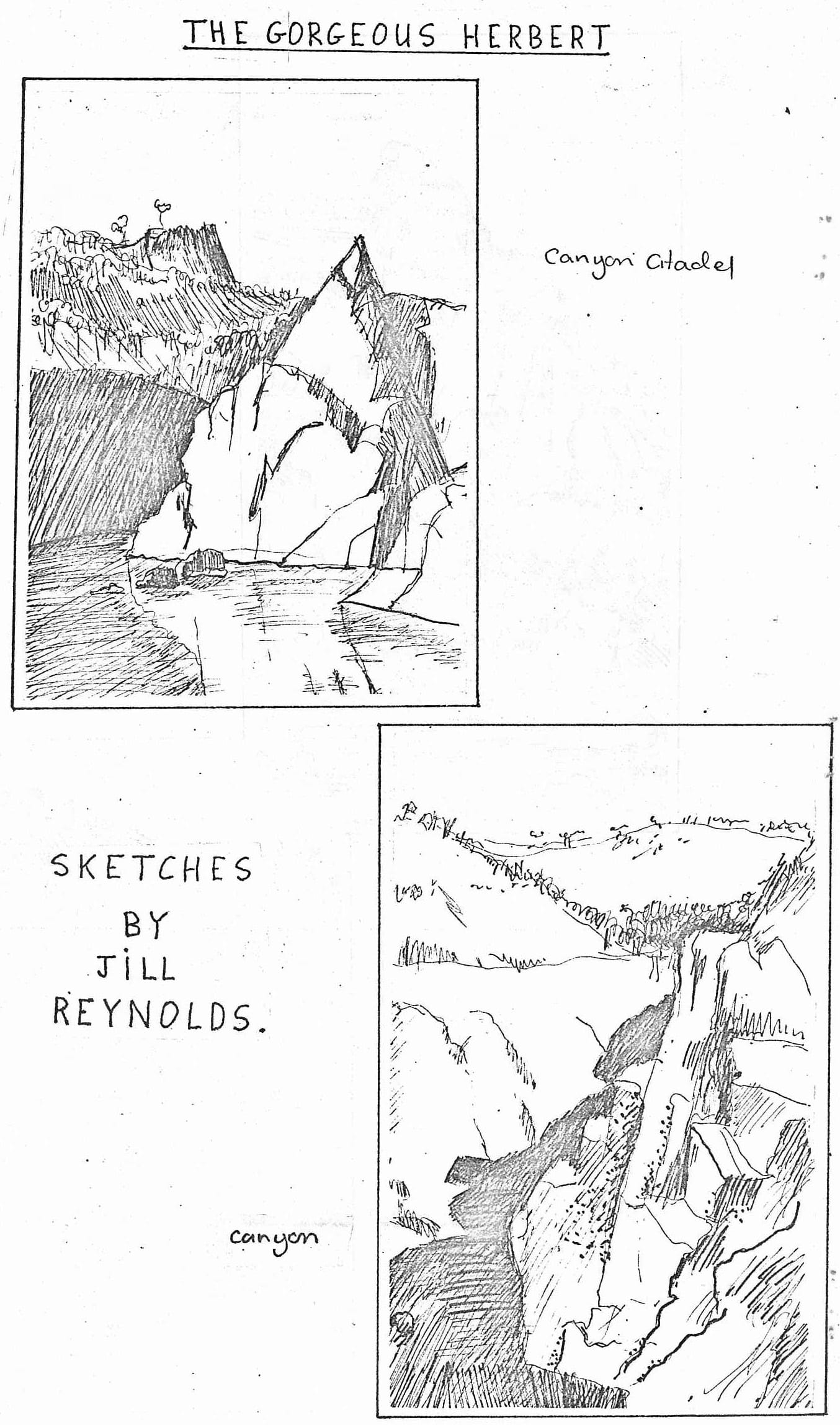
SKETCHES BY JILL REYNOLDS.
WHERE HAVE ALL THOSE CLUB MEMBERS GONE?
- Rick and Lee Williams are living at Halliday's Bay, near Seaforth. They welcome visiting bushwalkers.
- Pauline Roberts (our treasurer) is now tripping around the British Isles.
- Lilly Marcellos is now motorised (much to her amazement and joy), and now she can never be found.
- David Blair is still alive and well. He is now based at Brisbane Uni, and passed through Townsville recently on his way to T.I.
- Jan has arrived back in Townsville after 'Auzzie Passing' her way around the great continent.
- Roland Gregory plans to return to Townsville in 1980.
- Liz MacLeod has 'gone fishin' on the 'Rosalind Star' at Yeppoon.
- Penny Greet is now living at Dumaresque Railway Station (near Tamworth), and is attending the Uni of New England.
- Debbie Edwards has been cultivating ferns and plants in Sydney. She was recently in Townsville visiting her brother Chris.
After running into the dreaded Gympie on the Crystal Creek walk, Allan Watson tried every modern marvel of medicine to alleviate the sting. His list may be of some help to future unfortunates.
- intravenous antianflammatory - ineffective
- intramuscular antihistamine - only short acting
antihistamine cream - also short acting - Xylocaine jelly - better
- liberal dosing of 'Stingose' - best
Ron also has a list of the methods he has tried.
- shaving the area - ineffective
- sticky tape - ineffective
- singeing the area - ineffective
- hot water bottles - some alleviation
- Cunjuvoi Lilly - some alleviation
We now suggest that you carry some 'Stingose' when walking in Gympie country.
Through many donations from many sources, the Bushwalkers now have one of the best (if not the best) map collections in Townsville.
See the secretary for loan details.
GREAT TRIPS OF 1979.
- The Club has solved the Mystery of the Sword. In search of the Lost Sword, the Bushies drove and walked to the upper reaches of Sword Creek. A truly spectacular sight. On the same trip, the Bushies liloed down Garrawalt Creek to reach the top of the falls. At the top of the falls, they gave homage to the spirits of old bushwalkers who had found routes up an almost vertical slope. They also discovered platypus in the top pool - the same platypus of ten years ago?
- On this same trip, Robyn Eyre, being very civilised pitched a tent at the Garrawalt Forestry Camp - while all the other Bushies slept under sheets of corrugated iron.
- The Great Herbert River Gorge Trip was one of the most ambitious the present club has attempted. Six intrepid souls - Alan Watson, Ron Ninnis, Ann Duckett, Chris Smith, Jim Cameron, and Darryl Wright - walked, absailed, leaped, hopped, liloed, and swam their way down one of the most spectacular and inaccessible Gorges in Queensland. . On May 12, the party left Glen Eagle homestead, and three days later met up with Lilly, Harry and Jill at Bloodwood Creek. This area is a true wilderness - we watched from the opposite bank as a dingo stalked a wallaby, the dingo completely unaware of the intuders into its domain. It is easy to see how Harry fell in love with the Herbert.
- After completing this trip, Ron decided to see the whole gorge in one trip. He spent a whole day dragging and absailing himself and a kayak down the wrong ridge beside Blencoe Falls (over 1000 feet). Two wonderful days of rapids later, Ron + paddle + Kayak emerged at the end of the Abergowrie Road.
- Did you hear about the Frederick's Peak walk? The party stopped climbing at some rocky outcrops believing them to be 'Fred's Peak'. We have now decided to call these rocky outcrops 'Bob's Peaks'. (A fort-night later, the party returned to climb 'Fred's Peak').
- Alan Watson reports that the Kokoda Trail in Papua Nuigini is just like walking up and down Bartle Frere every day for five days in the rain!
- QUESTION: What has a skeleton 25' long, scales, and a furry tail?
This question puzzled Alan and Ron when they explored the upper reaches of Five Mile Creek.
ANSWER: A large python which had died with a freshly caught wallaby still in its stomach.
HEAT AND YOU.
The human body functions efficiently over a relatively narrow temperature range. A fluctuation of only a couple of degrees means fever or a chill. The body is geared to maintain a constant temperature to the inner core and brain. Temperature control is achieved by regulating surface blood supply by muscular action - shivering and sweating. The influences on body heat are humidity, air temperature, solar radiation, movement, clothing and fitness.
If you let heat strain go for too long or become too severe, something is bound to snap. If you collapse and lose consciousness, the emergency may be -
- sudden heart attack
- heartstroke (sweating stops and body temperature rises rapidly)
- water depletion collapse (critically low body fluid volume)
- salt depletion collapse (weak blood circulation, shock)
- hyperpyrexic collapse (over-heated body).
The hazards to look out for are -
- heat and heatwaves
- water - having an inadequate supply for the duration of the trip.
- unfamiliar country - check local weather, water sources and heat traps.
- unfamiliar activity or unexpected exertion - carrying a load that the body is not accustomed to or forced to take a detour which could be strenuous.
- heat traps - sandy or rocky areas exposed to the sun.
- excessive clothing - wear only what is necessary for protection from sunburn, insects, and physical injury. Do wear a hat.
When commencing the walk, particularly if it is already hot, increase your pace gradually until the pulse and breathing rates rise to normal working levels and hold that pace. Replace body fluids and salt regularly. It is best to keep them as close as possible to your normal levels. Walking in 32°C weather, you will sweat away about one litre of water and a level teaspoon of salt for every 70 kilograms of body weight each hour.
Stop and rest is the need arises, preferably in a cool shady place. Avoid walking between 11am and 2pm if necessary.
The signs of heat impairment are -
- general weariness involving all joints and muscles.
- headache, faintness or nausea.
- personality changes
- appearance changes
- abnormal pulse
- scanty dark urine (fluid depletion).
These signs may not be caused by heat strain, but when it is hot, suspect the heat. Keep within the safety margin - it may drop.
Treatment for heat strain -
- completely relax in the shade.
- if dry skinned or feverish, drench and fan the whole body to forstall possible heat stroke.
- give salty water and food if the body is low on fluid or salt.
Give slowly to avoid bloating and nausea.
In any case accept the inevitable delays.
Jim Cameron
Safety and Training Officer.
NEW WALKS OF 1979 (mainly)
- Hellhole Gorge from Star River.
- Herbert River Canyon.
- Palm Island - North East Bay.
- Five Mile Creek.
- Garrawalt Falls by lilo.
- The Mystery of the Sword (Sword Creek).
- Hinchinbrook Island by Canadian Canoe (H & J).
- MacKenzie Creek - Killymoon Creek through walk.
- Aboriginal Paintings at Deception Creek.
FUTURE WALKS
Sunday 18th Nov. PALM CREEK - leader, Les Hyland.
Thought by many members to be the best day walk of the club, this walk has deep swimming holes, waterfalls, and slippery slides.
Sa - Sun 1 - 2 Dec. MESSMATE CREEK and RASPBERRY FALLS -
leader, Allan Watson.
A new walk in the Mt. Fox area. A promise of a combination of dramatic falls and N.Q. rain forest.
8-9 Dec. RUNNING RIVER CLUB PICNIC at 'The Rapids'.
You can drive most of the way, there are wallowing holes, waterfalls, and beaches - an ideal place for stuffing oneself with watermelon.
LOST & FOUND
LOST —
FREDERICK'S PEAK
Would anyone knowing
the whereabouts of this
most important feature
of Townsville's land-
scape; please contact
several well known
bushwalkers at
once.
(That's all folks !)


