Ollera Creek
Ollera Creek bushwalk, July 1963: a 16-mile rock-hopping adventure in the Paluma Range near Ingham. The Townsville Bushwalking Club explored crystal-clear pools, granite outcrops, waterfalls, fish, tortoises, and colourful birdlife, camping under the stars with views of Circle View Mountain.
Location. Paluma Range Area. Coastal Slopes.
Date. 13th - 14th July 1963
Party. Ken Collett. (Leader.)
May Collett.
Richard Collett.
Pat Campbell.
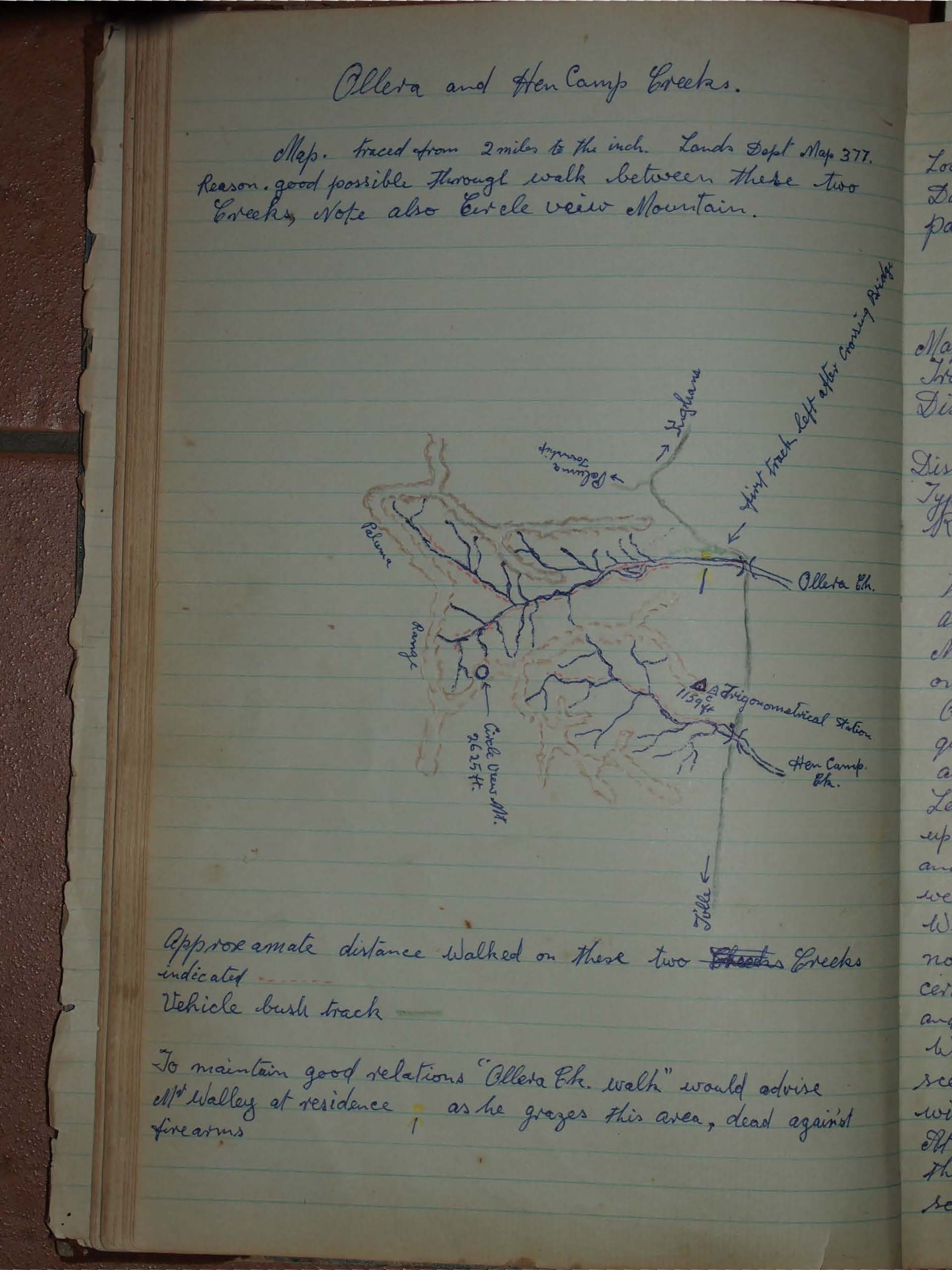
Map used. Lands dept. 2 mile series. 377
Transport. Dodge Car. Ken Collett.
Distance travelled by Car. { 40 miles each way Northern Highway
Total 84 miles } 2 miles each way Bush track
Distance walked. about 16 miles
Type of Outing. Mostly rock hopping, along creek bed.
Rating. Easy.
The party left Courthouse at 7-20 am Sat. 13th arrived at Ollera Creek about 2 miles upstream from The Northern Highway, about 8-55 am. The car was parked on the creek bed incase of bushfire.
On reaching this spot, we were delighted to find quite a good flow of water for this time of the year, also a nice picnicing area, our first club visit here.
Leaving the car at 9-10 am we walked a mile or so upstream to a large bend in the creek bed, the time and place were right, so here we all enjoyed that well known Ava cuppa.
We then investigated the large bend of the creeks, noting a camp on a high bank and an old man nearby, certainly in quiet retirement. (Shady trees, a babbling brook, and perhaps a good book).
We made leisurely progress, enjoying the increasing scenic beauty, and crystal clear sunlit water-holes with many coloured stones glowing in the bottoms.
At 12-45 pm a stop was made for Lunch, pat. C. doing the honours for Ava-cuppa. While at Lunch we had several visits from pretty blue Butterflies, and from small brightly coloured birds with throats as red as the blooms of the Bottle-brush.
Shortly after leaving Lunch Camp, we came to a large rock pool 5 or 6 ft deep, where Pat saw several large perch which, she decided, would make a tasty evening meal, we all agreed the only catch was we had to catch the fish. This proved very difficult, so the menu was changed.
Five to six large pools were seen on the main creek mostly in red granite outcrops with five to ten feet of water at the deepest point and fish up to two pounds in weight.
The weather for walking was ideal, and there was always something interesting to see flowering bushes and trees, birds, butterflies, fish and tortoise.
Base camp was made on a flat rocky bend at 3-20pm where packs were left while we explored about another 1/2 miles further upstream the growth growth here became more jungle like with several mountain peaks in view, one I think was circle view which was seen a couple of times earlier.
Pat Campbell drew attention to some wild raspberries she sited in the section.
During the night at base Camp, something tried to drag off some gear a sandshoe, and a camera in a leather case, the sandshoe was moved about 14 feet.
Base camp was hard, and cold, but a cheerful fire was maintained all night by Ken, and giving us a nice warm breakfast in the morning we soon forgot the night, leaving Camp at 8-45am Sunday for the return trip.
About a mile downstream a large branch stream was explored for about a mile or so it proved a nice interesting creek worth further investigation (deep pools and fish.)
We had hoped to see some sign of mineral and Mining but none were seen.
We proceeded downstream in easy stages reach-ing the car at 3pm and leaving for home at 3-30.
We arrived home at 4-45pm quite satisfied that we had had a good weekend.
Before the late entry of this trip in the logbook Pat E. had sampled some fish previously mentioned, baked over the coals. (very delicious said Pat).
Also the large branch creek was revisited and further explored but owing to being only a day trip the head of the creek was not reached.
This time making a little over two miles upstream still very interesting and worth a weekend to further explore, fish, several tortoise, and 2 eels about 30 inches long sighted.
Many large rock holes up to ten feet deep, and large rock faces on creek banks, with boulders in creek bed getting very large and plenty of them.
Exploring strange places. Adventure, Curiosity.
What is around the next bend ???
Lets go and see
Ken Collett.
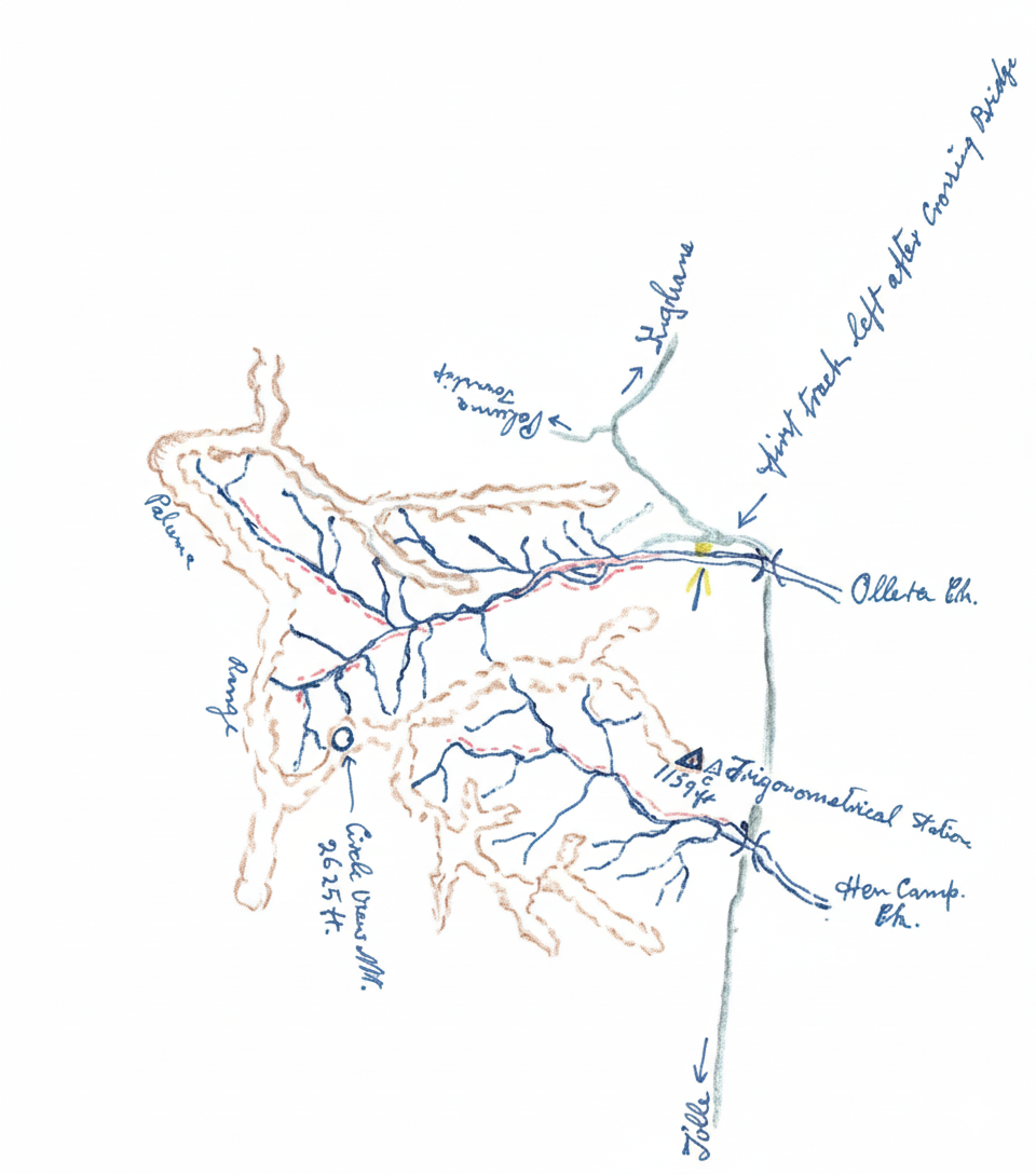
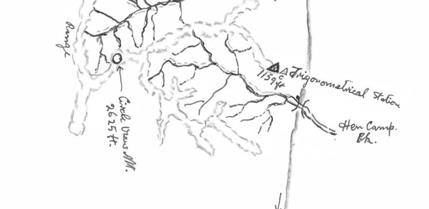
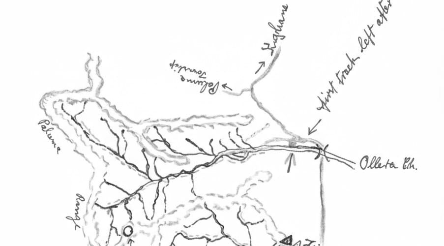
Approximate distance walked on these two creeks.
Indicated by red dotted line.
Vehicle bush track green line.
To maintain good relations "Ollera Ck. walk" would advise Alf Walley at residence as he grazes this area, dead against firearms.
See also: