Pelorus Island 2017
A three-day island adventure with the club on Pelorus Island, featuring camping on the coral beach, rainforest traverses, summit walks, snorkelling reefs, oysters at low tide, and stunning coastal views. Rugged, remote, and unforgettable.
‘the winds ain’t blowing, so we are going’.
For some time we have been attempting to organise an island trip. But sea conditions and availability of suitable boat for our group size meant it was never achievable. But this time, the sea conditions were good, weather forecast was good, we had a suitable boat, therefore the ‘tough’ island trip was all go.
Pelorus Island is a small island about 1.5 km wide by 2.5 km long, with a highest peak of 271 metres. It is also known as North Palm Island, and is the northern most part of the Palm Island group. Western side is accessible, but northern and eastern sides are coastal cliffs and rocky headlands.
Nine adventurers caught the boat from Dungeness (Lucinda) at 8 am on Saturday for a three day island explorer on Pelorus Island. There were discussions with the boat operator in the days leading up about maybe needing two trips (depending on how much gear/weight we had), or maybe we go on a bigger boat with another group. But on the day, we fitted into the one smaller boat. We limited our weight to 15 kg packs and 15 lt of water each. Well, most did, I was certainly more than 15 kg pack, but hey, I organised the trip so that was ok. No facilities on the island nor water resupply, need to be self-sufficient for three days.
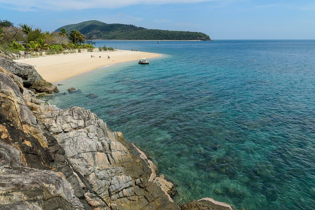
Arriving at the island at 9am, we went to the northern beach – I expected we would go to the southern beach, but that has private property lease. Three boats all arrived at the northern beach together, so we quickly unloaded and raced up the beach to claim good camp spots. Therefore there were three groups on the beach, but plenty of room to spread out. NQUEC had nine in their group as well (but a lot of gear), and the dive company had similar sized group at their semi-permanent camp.
At 1230 pm, we set off for a walk. There is a lovely coral reef 30 metres off shore for great snorkelling, we could sit under trees on the beach and daydream, swim in nice water, but no, we go for a hot walk on rocks. Well, we did not want people getting bored, so had to do it ! And you never know, a better spot might be just around the corner or over that hill ……
Going south, scrambling over a rocky headland, then along a mangrove beach, then another rocky headland that provided bit of a challenge, onto the southern beach, a lovely sandy beach with beautiful water. This is where the private property lease is. That took one hour. Orpheus Island was a short distance to the south across the channel, and in the distance can see other islands. We kept going along the southern coast of the island, this was turning into a circumference walk of the island, maybe. It is only 2.5 x 1.5 km, so how hard could it be ? Low tide, stop for fresh oysters, RL even managed to get one down this time. Continue along the rocky beach, then the rocks get bigger. We find some spotted eels in the rocky pools, plus other creatures. But no sign of any goats or ‘dingoes’ (for those that know the story). “How far are we going?’ starts to get asked. ‘No good asking us leaders, we are just exploring, who knows where we will get to’. But ‘all the way around the island’ was a fermenting idea. Further along on the south east edge of the island, the coastal cliffs get large, then we are blocked by sheer drops. We had come 3.5 km. We think of cross country options, but decide to go back to camp the same way along the south and west coasts. Tomorrow, we will have a real full day adventure – circumference then traverse of the island, easy plan. Albeit, review of the satellite photos, that east coast looks awfully rugged - doubts about circumference start to surface after seeing that south-eastern coastal cliffline. Back at camp for a pleasant swim, then a good night around the camp fire.
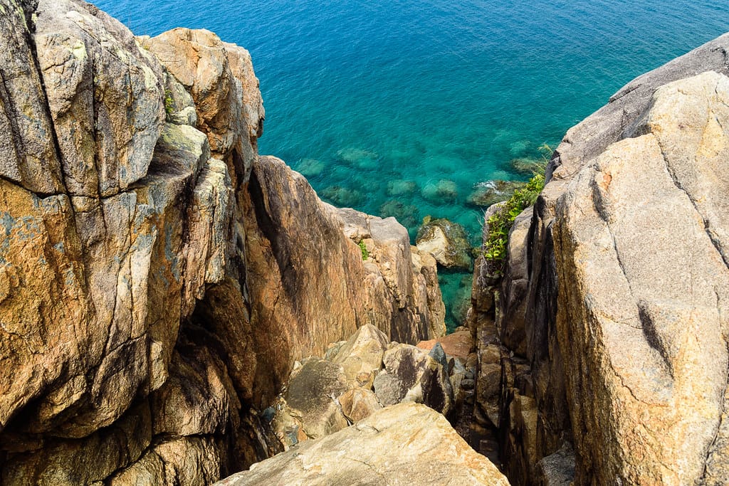
Sunday, six of us head off at 9 am for the full day adventure. Decide to do the traverse first, then circumference later at low tide. Leaving behind a perfectly good beach, swimming and snorkelling, prepared for a bush bash to the summit (why ? – because it is there and we must do it !). We go north to try a ridgeline, and find a marked route. Follow that up the ridgeline, easy going, no bush bashing. A junction with a side track to Barnacle Beach (north east corner of island), we can try that later. Continue up along the ridgeline, following the easy trail, to reach the summit. Heading south, start a short descent, then we leave the marked route and head for the east coast. Now bush bashing but easy going, enter a dry creek line, have lunch. Looking at the GPSr, we are almost at the coast, but still 100 mr elevation –‘we must have a big drop off ahead’ I was thinking. Nobody else seems concerned though. Shortly after, we found that drop off, 50 metre cliffs into the ocean, and the creek drops down a steep chasm into the sea. Awesome views. But how do we get through this ? We try to find a way, we can get down to platforms near sea edge but can’t see around the corner, and this coastline will be all steep cliffs and blockages and not viable. Try the vegetation area at top of the cliffs, thick gnarly coastal stuff that we can’t get through. We stay here for a while to admire the views, clear water, and see three turtles below. Dreams of kayaking the island instead now surface. Or maybe a rock climb/ swim / rock climb / swim along the coast for the super adventurous?
We need a shortcut (our shortcuts are infamous though) ! Back up the hill. Aim for a southern saddle so we can come down into ‘goat skull creek’ at the mangrove beach is plan A. Back track up the creek, then get out of the creek as the ground next to it looks clear. But that illusion lasted 50 metres as usual, then into thick viney tangled scrub. The usual cursing as we climbed and bashed our way through the never ending stuff. Ah, a lovely tropical paradise island – well, not here it ain’t. It is hard going, hot and very humid, the saddle seems long way off, the vegetation is thick, the fun has stopped (for our leader anyway, the rest are loving it). Modify plans again, aim for the ridgeline to re-join the marked route. ‘Wonder how far we are from either coast ? – check the GPSr’ is the question. Reply is ‘uh oh – 700 metres!’, gave everyone a laugh (remembering Mt Bowen).
But at flag point thirteen (a marked route junction) before the summit, after the 1.1 km bush bash from the east coast (1.5 hr with a rest stop), we have a choice, the way back we came along the ridgeline over the summit, a known and safe route, or try this unknown but seemingly direct downhill route via ‘goanna guts creek’. Being a democratic equal group (only for a brief moment), three females, three males, the vote was 3 v 3 – the three girls wanted the unknown but shorter promised route, us three wiser males were cautious. But a 3 v 3 vote meant the girls won (how does that work?). Actually, the club is autocratic, not democratic, but on this occasion, I think the heat and humidity made us men soft (and some of us are battle scarred from previous shortcuts). So with the girls vote winning (meaning they get the blame), we take the direct marked route back to camp. Us men take no further responsibility for what is about to occur ! Somebody had recharged Phil’s batteries because he took off at great speed down the range, with Anneliese in hot pursuit. Down forested slopes, easy going, no bush bashing, then down a dry creek bed (which seemed to go on forever), back to the beach at 4:20 pm for a welcome swim. Well that was timely and easy home route! The walk was a total 7.1 km distance. At night, listening to the NRL grand final, it started to rain a bit. Flying foxes winged overhead. Curlews made their usual noise.
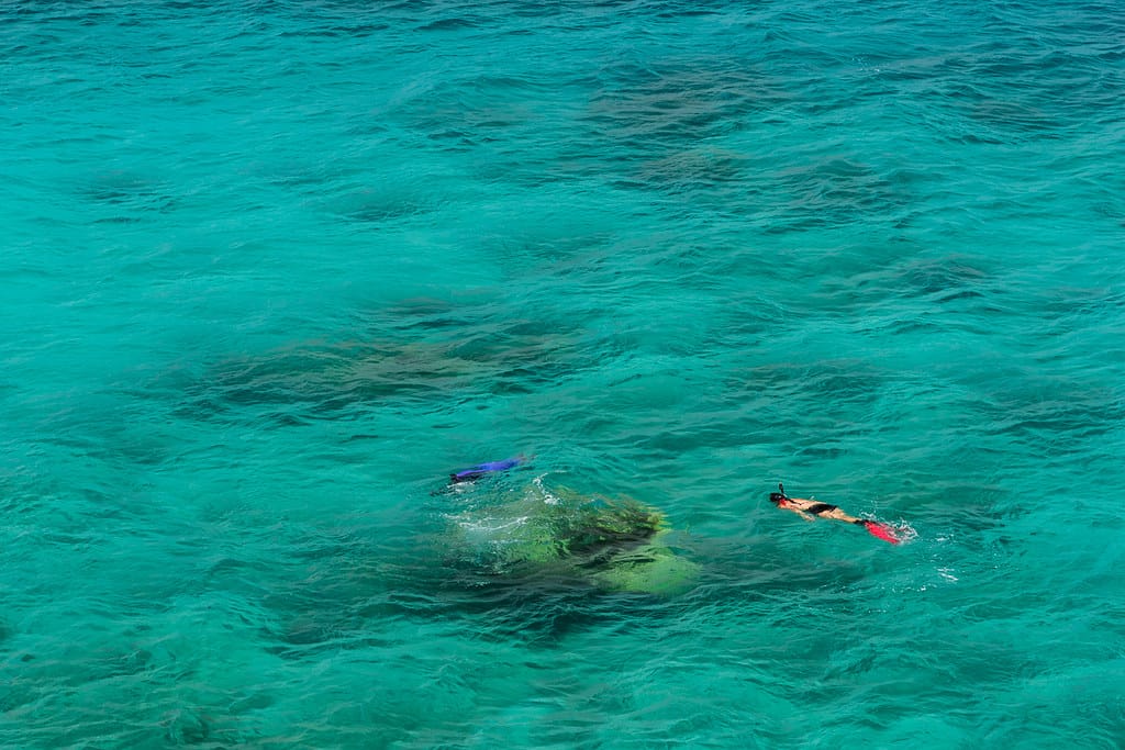
Monday – A sea eagle soared over the beach. Boat time changed to 1:30 pm (from 4 pm) so we cut back on exploring time. We had planned to go over the ridgeline to Barnacle Beach on the north eastern side, but not to be. Most enjoyed the morning snorkelling. Rays, octopus, colourful fish and other creatures are found on the coral reef. Although the bottom dwelling shark sighting seemed to have dimmed enthusiasm for some. Then we went for a bit of an explore at northern end of the beach and island, found it is rock headlands and cliffs up there too, but beautiful water and coves. 1 pm, all packed up, the boat time changed again, so we lazed about waiting. At 4 pm, the boat is finally ready. We are going back on a bigger boat with NQUEC. A pleasant boat ride home, back at Dungeness at 5 pm. Then drinks and dinner at Lucinda Hotel. Another great weekend.
NQUEC often go to Pelorus as base for their underwater exploring trips. They look for people to fill the boat they charter on their trips, and there is an option for us to go over with them to the island, and we do our own thing on the island (or can join them for remote snorkelling). That is a cost effective option to get to the island, and provides a means of going to the island more frequently. And, we can take more gear !
The camp beach is predominantly broken coral, with bits of sand, and rocky underfoot at low tide. The camping is beachside on dirt or leaved area, with morning shade, but limited afternoon shade. There is excellent snorkelling off the beach and around the nearby rocky headlands. If no wind, mozzies and sandflies are noticeable. A great location for a good weekend.
Using the marked traverse route to the summit plus optional side track to Barnacle Beach, then down Goanna Guts creek, makes a nice easy day walk, total about 4 km, highest point 271 metres.
From camp to summit via northern ridgeline track – 2 km.
From northern ridgeline track ‘Barnacle Beach junction’ to Barnacle Beach – about 500 metres (camp to Barnacle Beach via northern ridgeline track – about 1.4 km).
From flag point 13 junction (just south of the summit) to our camp beach via Goanna Guts creek track (direct route) track – 1.3 km
Oh, and we are still an autocratic club, so don’t get any funny ideas !!!! J
da Prez


