Porcupine Gorge Easter 2018 Report
Four days, countless creek crossings, and one very grumpy leader until his “special red” was found. Porcupine Gorge delivered fast water, tough scrambles, sandy camps, laughter, and a trip to remember.
Easter 2018
A creek crossing or two .. or three…. or more ………
Grumpy.
Mr Grumpy was leader.
A missing bottle of special red rehydration liquid was the cause. Searched home high and low for it, dismantled the spare room, searched everywhere. And not just once, but over several days. Bugger, must have left it in the hotel at Jindabyne last week – but searched that hotel room three times before we left Jindabyne to ensure nothing left behind.
Setting up camp, ask EV ‘in that pack I lent you, you didn’t find a small bottle that looks like red wine did you ?’
“No”
Hmhmhmhm grumble grumble.
In the background, someone had a quite giggle (unbeknown to our grumpy leader) ……….
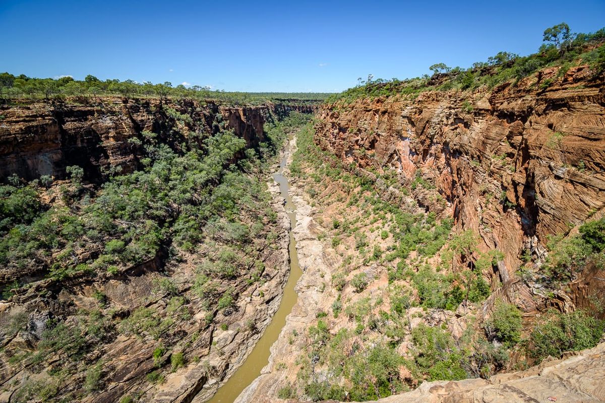
Porcupine Gorge, a four day 27 km remote bushwalking trip. Located 71 km north of Hughenden.
BOM river data Porcupine Creek (think this is well below the gorge near the bridge) on Friday 30 March read 0.11, a good indication that creek level would be normal and nice. The creek had recent good ‘flush’ with levels of up to 3 mr two weeks before. On the 28th March it had a rapid rise up to 1 mr, but as usual fell rapidly back to 0.11 by Friday. By Monday the gauge was reading 0.01. Porcupine Creek at Emu Plains (upstream) read 2 mr Friday, and 1.72 on Monday. In hindsight, maybe we need to take notice of the Porcupine Creek Emu Plains reading for the gorge creek levels in future rather than the downstream bridge data!
Easter Friday
8 km walking.
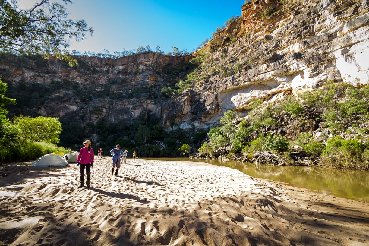
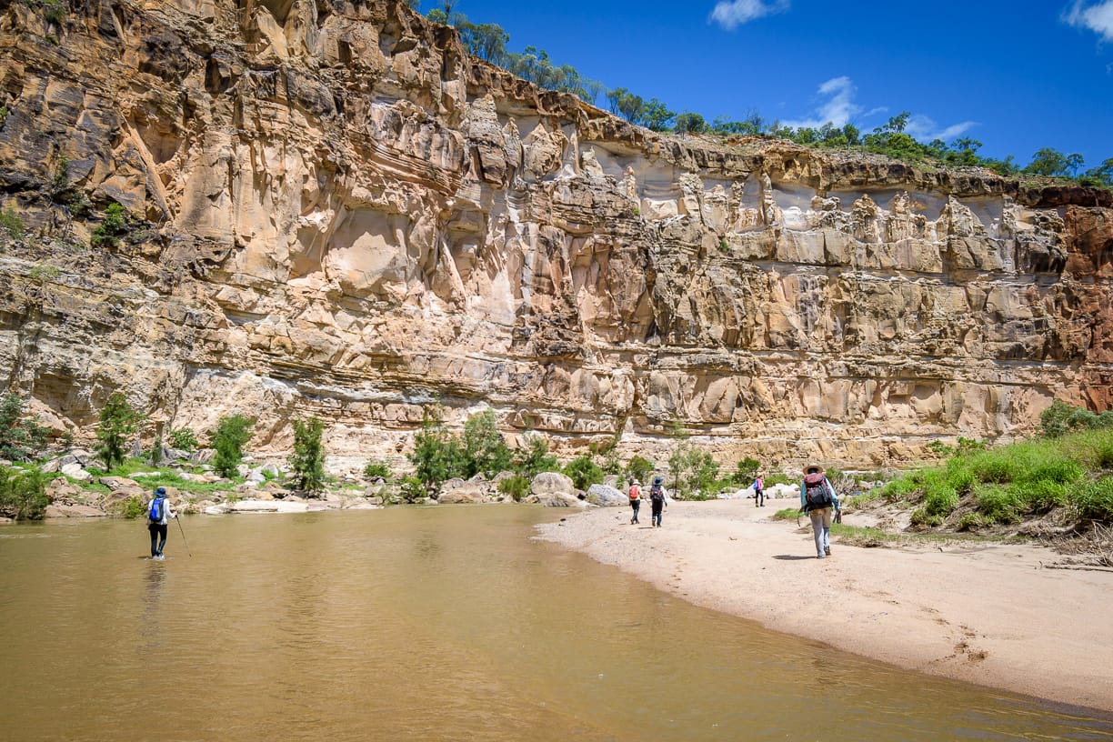
Nine keen adventurers. With briefing that included to expect several shallow creek crossings and we do not stop to take boots off, a gentle walk along the riverine environment of the gorge, camp on a nice sandbank, all are ready for an easy adventure. Although, on Saturday, we might push on further than we have previously, past the lookout area to the next gorge bend to hopefully Prairie Creek junction (yes, there is always another bend to look around). Depart Stuart at 6:15 am, short stop at Charters Towers, then pre-lunch stop at Hughenden, which became a lunch stop. Then drive 60 km north to Porcupine Gorge Lookout. On the way we cross Porcupine Creek bridge “uh oh, the creek is high, flowing very fast, and brown and turbid, that is not a good sign”. Silently I am also thinking “oh damn, I don’t want to be drinking that creek water for four days if the gorge water is like this”. 60km north of Hughenden, stop at the lookout for grand views over the narrow gorge. Standing on the lookout gorge rim sheer cliffs, pointing below, our leader says tomorrow we will be down there having lunch. The group looks on in amazement ‘what, really, down there? How?”. And down there in the gorge you can see the creek is flowing fast, brown and turbid. Drive 11 km north to the National Park campground, park cars and put backpacks on. Some in the group look startled as the leader puts on a day pack – what the ?
“Aren’t we going for overnight?” they ask.
“Yes” is the reply.
“But, you only have your day pack on ? Why do we have these big heavy packs but you only have day pack ?”
A smile is the reply.
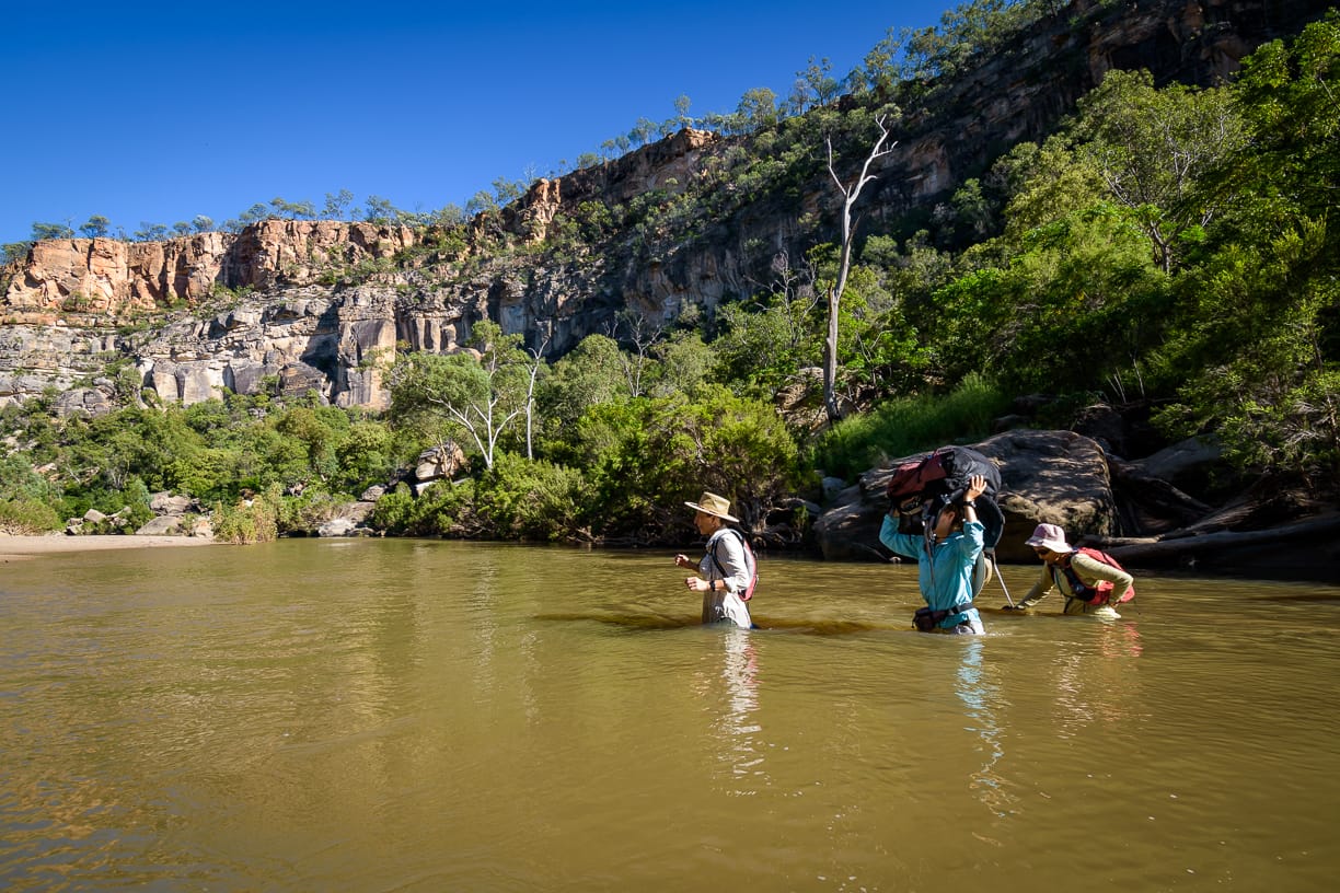
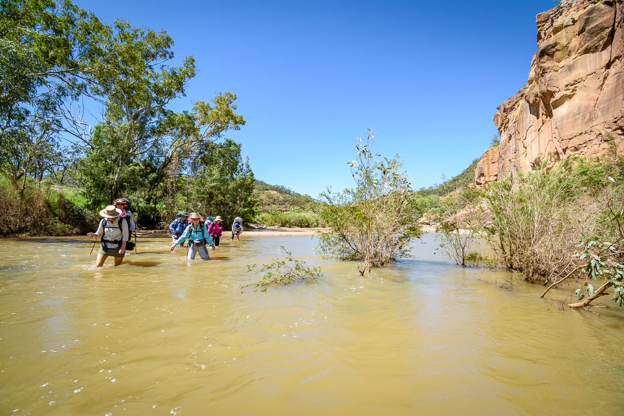
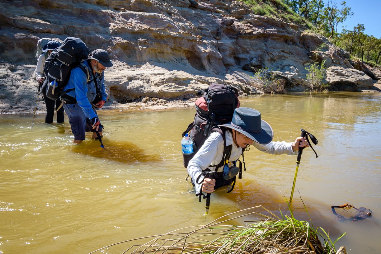
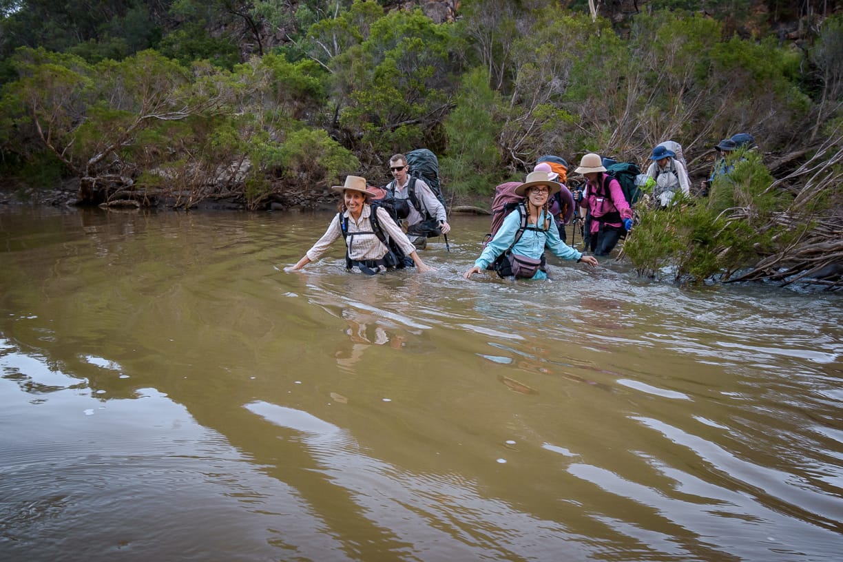
A 1.2 km hike on track down into the gorge to the Pyramid. From now on, no more tracks, true bushwalking. At base of the Pyramid, the creek is high and fast, our first crossing. Our leader wades into the flowing turbid creek water, whilst the rest of the group waits on the shore, to see what would happen to the leader. Knee deep …. thigh deep …. almost waist deep…….backpack bottom almost getting wet now, then he is on the other side. So there is the leader on one side of the creek, the group on the other side, just staring. “Well. Come on, cross over” the leader calls.
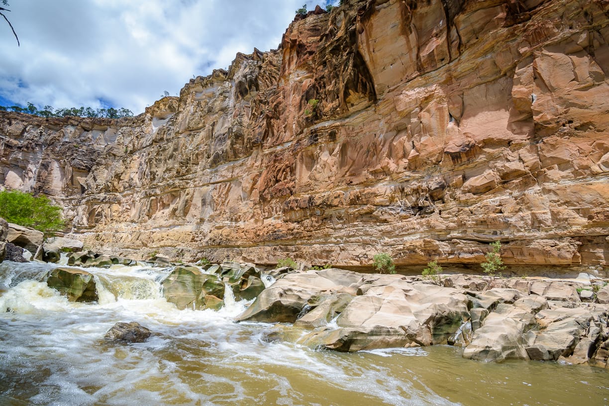
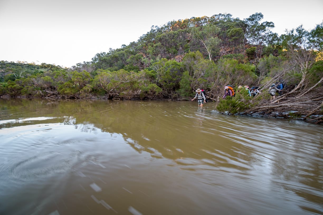
“What, we have to follow you? Your six foot tall, some of us are a lot shorter you know, and that was over your waist!”. “Toughen up princesses”. As they cross over to join me, I look at that turbid water, thinking again, oh crap, I don’t want to drink this water for four days. Ah well. We then proceed on the east bank, heading south down the gorge. Plan is to get to the Amphitheatre 6 km walk downstream from the Pyramid this arvo to make base camp. Minor rock hopping, long grass walking, and through trees. We then try to get to the west bank, but are blocked by a creek channel that looks too deep. So we bash our way down an island (how did we get on an island ?) through River Tea Trees Melaleuca bracteata, stumbling over fallen branches and in soft sand, slushing in shallow water, looking for a crossing point, but the two creek channels were deep looking or too fast flowing. Finally, we find a suitable looking crossing back to the east bank, not sure how deep, but just have to try it. Borrow a hiking stick from Brent to use as depth measure, our leader plunges into the creek and wades across, again over waist height. This was to be a common result for the next three days. At one crossing, a call of ‘CROC” startled the group – relax, it was the croc shoes hanging off somebody’s pack . Sometimes we tried near rapids where water might be shallower, but the current was very fast and have to scramble through tea trees and roots making that a bit difficult as well (with hidden rocks in the water just to add to the adventure). We stay on the east bank, for a while that was good being on level rock platforms , easy, and very scenic. But at a small gully dip, that is always dry and easy, it is wet, muddy, and steep, so that was difficult for some to get across. And a red ants nest on the exit where you put your hands as you scramble up the mud slope just increased the fun.
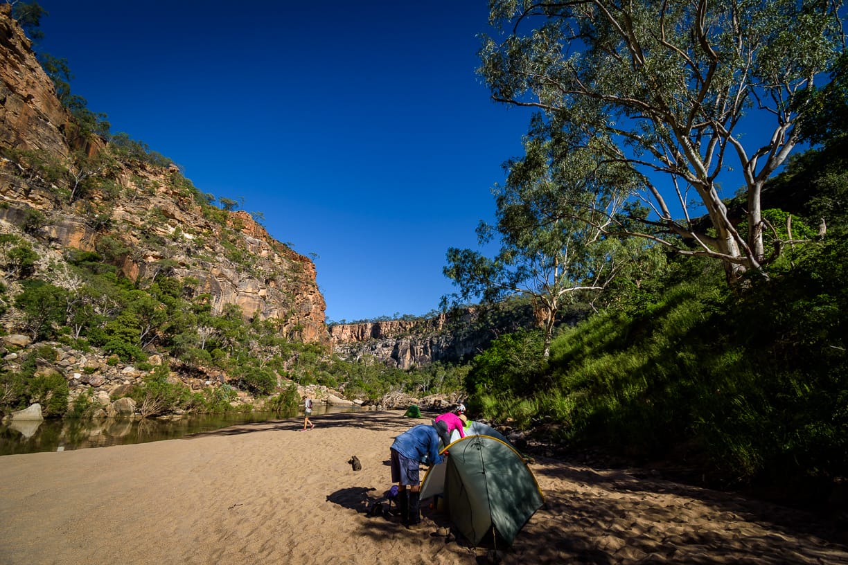
Up ahead, the easy rock platform gave way to a mass of scrambled boulders blocking the way. But the creek channel here is too fast and deep to cross to the easier west bank. We scramble through the boulders, through knalry trees, then long grass, muddy creek bank, we are slow moving. With the creek level high, I am concerned now that maybe the sandbar at the Amphitheatre is either under water, or washed away. It was getting late, so time to think of contingency camp idea. It has been a harder day than expected. At 5 pm, we are not far from our destination, but it is late and we are tiring. We find a sandy bank, not the best, but we could fit the group in here. Just ahead though, is the high cliff of the Amphitheatre - blocking us though is a potentially deep crossing. Will the planned camp site there be suitable, or washed away, or under water ? Four of us charge off to find a way across the creek, flowing fast and deep at top of a rapid (but better than a longer deeper pool above), then race around the bend, spotting a bunny rabbit (yes, it did have a white tail), then to find ………………….
The four chargers retreat back across the creek to re-group with the others. Heads down, very wet, put packs on and head off – the rest bewildered “what are we doing ?”…. “just follow us !”. The creek crossing was a bit challenging with heavy packs, fast flowing water, chest deep for some, and rocky underneath. Saturated, onto land, around the corner to present to the group ………. a magnificent long dry sandbar in the Amphitheatre, a great camp site. It was 6 pm. That was a harder hike than expected due to the conditions. We put a tide marker on the creek edge to monitor the creek level, and planned an evacuation route if required to higher ground just above the camp site. Set up camp, relax, swim, gather water. A pleasant night under a full moon and stars, and a great camp site. The usual camp discussion about food, gear, weights, pack set up, and past experiences. At 8 pm, those who were tired were allowed to go to bed (club rule - 8 pm !). It was a warm night but became bit chilly in the early hours on the next day. Some rested or slept on the sand for a while.
Saturday
Sitting at camp, wedge tail eagles soar above, and kestrels and currawongs dive around the cliff rim.
10 km walking.
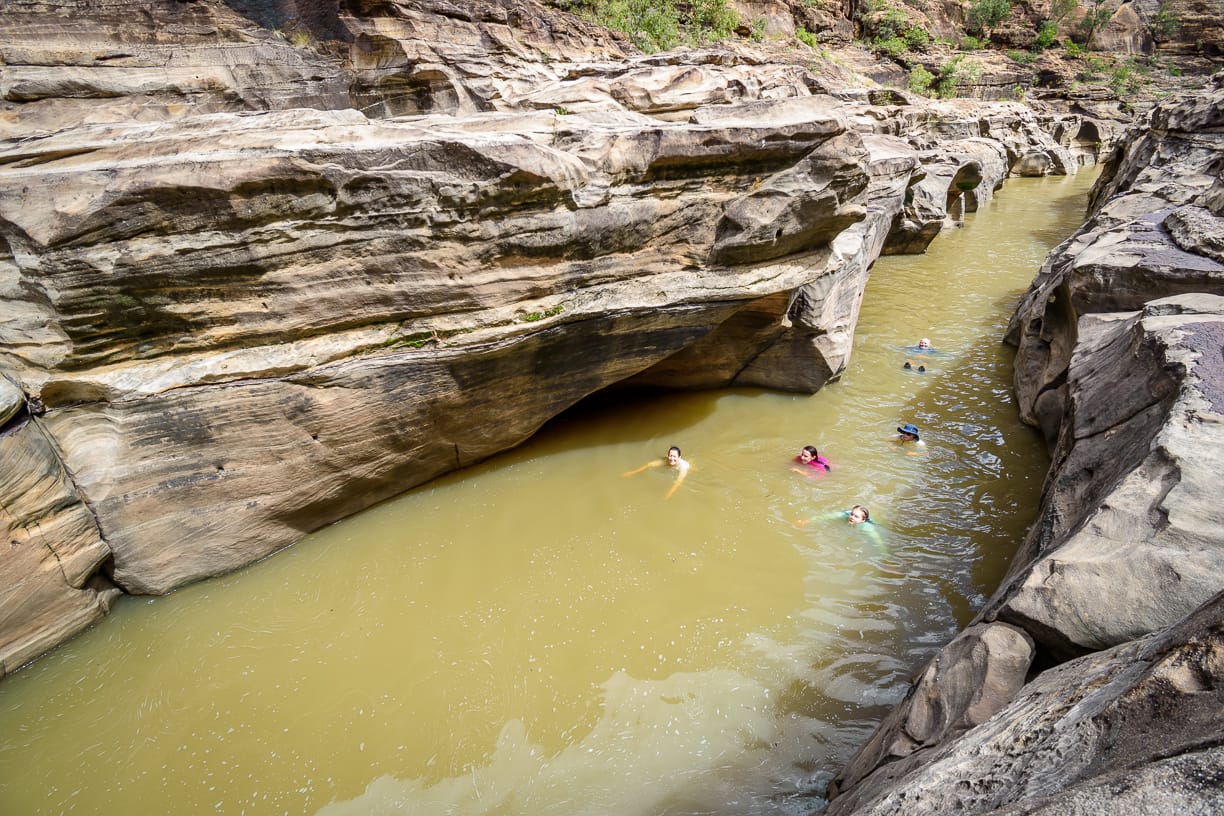
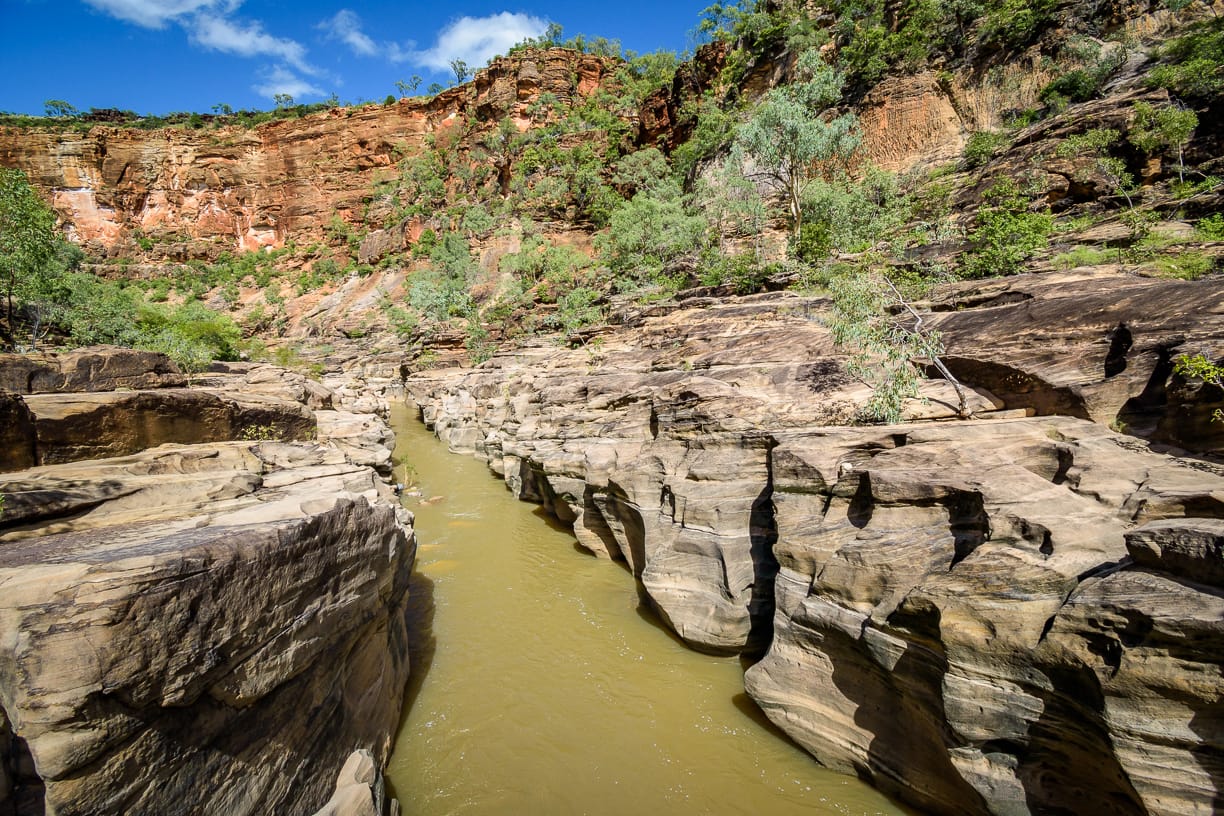
Plan today is a day walk, to the area below the lookout and hopefully push on further than we have done previously, maybe to Prairie Creek junction. But the creek level is a concern, we might get blocked, so see how we go - maybe we can’t do what we plan. The gorge is narrower from now on and so the creek might be faster and deeper. Shortly after leaving camp, we need to cross the creek – usually ankle / knee deep here, but today, looks deeper. We bush bash for a short bit, but then we need to cross, regardless. Damn, that looks deep. Borrowing Brent’s hiking stick again, the leader plunges in, and sinks, and sinks, almost chest deep. But it shallows up quickly, a sandy bottomed cross. Looking back, the group is still standing on the bank, watching, waiting. “Well, come on!”. A morning of numerous creek crossings, enjoyable in great gorge scenery. We come to bit of blockage, but KG finds a route over or through the boulders, that was easier than expected. At 11 am we are beneath the lookout, a grand sight. Late smoko stop is called. Five adventurers race upstream a bit, to float down the narrow gorge, lot of fun. We always talk about lilo or packraft for this part, must do it one day. From now on, it is exploratory – do not know what to expect as we push on. A side creek and gorge joins from the east, is that Prairie Creek ? - does not look big enough, but be good to explore up there one day. The gorge widens a bit, the creek is sandy and shallower, so we spend lot of time wading in the creek. Around the corner, a high white sandstone cliff beckons. We splash our way down the creek, shallower here, to make a lunch spot at good rapids opposite the white cliff, under a nice gum tree. Awesome location. Study the map, Prairie Creek is still 7 km downstream (the joy of QLD topo paper map using 1966 data) – oh well, that will await for another trip. After a good lunch break in an awesome location, we head back to camp, enjoying the creek crossings (and constantly wet sandy footwear), back to camp at 4:15pm. That was a great day. If only I had a drone still ....
Sunday
6.5 km walking.
Easter Sunday. Awake to see the Easter bunny has been to the camp – scrambled chocolate Easter eggs dotted outside our tents – yep, they melted into a congealed mess (again, happens every year out here). Meanwhile, KG sitting outside her tent, as the leader walks by. KG is holding a small bottle of red wine with pink ribbon, waving it at the leader. “This is a nice drop” she says. Leader looks “oh, nice, had that blend before.” ….. “Well, it is for you”….. “oh, thank you, very kind”…… . “No, I mean it is yours”…… “you mean for me to keep?”……… “YES. Yours, it is your port”….. “What ? – hmhhm it does look very familiar actually”….. “Yes, well, Someone at Jindabyne ran into to the girls room with it giggling, so here it is, it’s your port”. Slowly, it dawned on the leader what was going on. KG then said “and I giggled when I heard you ask EV if it was in the pack you lent her, and how you explained you have been searching for it all week, been giggling all weekend”. Right !!!
We pack up late, move camp up closer to the Pyramid. Where exactly don’t know, depends on sandbars, but I do have an area in mind. Two creek crossings, the creek has been dropping all the time, so easier to cross, albeit still a few chest deep spots (some cameras and phones got wet). We use the west bank which is easier walking. At 2:15 pm, we reached a nice sandstone feature with small cave and a sandstone stockade (for floggings and chopping heads off),, with a nice flat rock bar, and some sand, and beautiful creek scenery, and decide this is a great camp site, 500 metres from the Pyramid. Seven attack the climb to the top of Pyramid, but the creek crossing our dear leader took us on, was the deepest of the trip – it was at top of the chest for most – some worried looks on faces. After the Pyramid climb, we split into sub-groups for the short walk or swim back to camp. KG and C float from the Pyramid down to camp site - well, float for a tiny bit, most of it was fast rapids so they scraped and stumbled through, lot of fun. Next to the camp is a cliff, with a large cave facing the creek, that we explore. A great camp spot, and another good night. Our leader was no longer grumpy, having that special red rehydration liquid for happy hour at camp.
Monday
Pack up. 2.7 km walking. To avoid the last two creek crossings (we are tired of wet boots, wet socks and sand in our footwear), we climb above the cliff nearby for a great morning view (except my camera was dead from getting wet yesterday), then cross country over to the Pyramid area. Quick swim, then the 17 minute 1.2 km 185 metre ascent up the escapement to the cars. Drive back to Hughenden, stopping for a frill neck lizard on the road. At Hughenden meet the club ladies heading out to the gorge for their five day adventure. Told them it was only ankle deep in the creek ! (snicker snicker). Also asked if I could join their over 60s walking club, to be told “NNOOOOOO” by Chief Mutineer. JV was amazed when Paula said her five day pack was 10 kg (without water) - “how the hell does she do that?”. At Prairie Hotel stop for lunch. Then the drive home, quick stop at Charters Towers, on to Townsville. Another great trip.
Amazingly, considering the number of creek crossings and uneven underfoot without visibility, nobody fell into the water. A few stumbles and close calls, but no ‘all in’.

Next time, we should try to go further past White Cliff - maybe a walk through of the whole gorge ?
Future reference:
For creek level, suggest we need to take notice of the BOM Porcupine Creek Emu Plains station reading for the gorge creek levels in future(not the other one)!
West bank is generally the easier walking except the bend nearing the Amphitheatre.
Lilo or pack raft down parts of the gorge would be an excellent adventure.
Did you know that the spirit bottles for Trangia, have a safety valve lock to prevent spillage ? So when you are half way through the trip, and notice lot of fluid has been leaking, which means you have a faulty bottle and need to return for exchange. Until another member says “give it here”, then twists and turns to lock the valve and cap – no more leaking - “oh, bottle not faulty”.
“You told me a fleece was not required for night time – I froze last night !!!
“You told me it was suitable to wear shorts and no gloves, no bush bashing, no boulder scrambling, easy walking, no scratches – my legs and hands are grazed, abrased, scratched, cut, bruised, toe nails lost polish, finger nails a mess .....”
“I found something in my sleeping bag – 4 year old crusty underwear, and not mine either ...”
At Prairie Hotel “pie with salad thanks mate” .... Publican responds “Never heard of that, see what we can do” ..... PK clarifies “salad goes on the side mate, not inside the pie !”
Porcupine Creek on Porcupine Gorge National Park is a major tributary of Flinders River, which flows to the Gulf of Carpentaria. It cuts through a hard basalt cap to form a deep gorge about 120 m deep in the underlying sediment and metamorphic rock. The gorge’s geological history dates from between 500 and five million years ago, including areas containing Permian glacial sediments and a section of Cambrian-Ordovician Cape River beds. The gorge’s eastern rim has a five million-year-old basalt flow, indicating the creek cut the gorge after this time.
Walking Data
NP Camp ground to Pyramid 1.6 km (25 minutes), descent 143 mr.
Pyramid to Amphitheatre 6.4 km (3 to 5 hours depending on route and conditions)
Amphitheatre to Lookout area 3.6 km (1.5 to 2 hours)
Lookout area to White Cliff rapids 1.9 km (40 minutes to 1 hour)
Sandstone / Cave camp to NP Campground 2.7 km, ascent 185
Whole trip walking – 27 km, Ascent 512 Descent 521 (excludes Pyramid side trip climb)
Potential future plan
Drive to Hughenden evening of the day before, be in position to start walking in the morning.
Day one walk to White Cliff, make camp. Day two to Prairie Creek junction, camp. Explore side gorges. After that, who knows !