Texas Terror - Mt Straloch (Hinchinbrook Island)
Twelve hikers tackled the steep climb to the WW2 B-24 Liberator Texas Terror wreck on Mt Straloch, Hinchinbrook Island. After a long day of rock-hopping, rope climbs, stinging trees, and close calls, the group reached the memorial cross before descending to meet the boat—tired but elated.
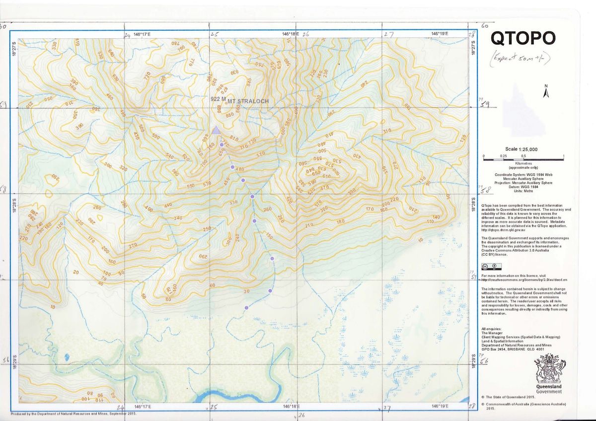
We planned a one day hike to the WW2 bomber wreck ‘Texas Terror’ on Mt Straloch (Hinchinbrook Island) on Sunday 22 Sep 13. The climb to the wreck site and back can be achieved in a ‘long’ day in good conditions.
Texas Terror was a B-24 Liberator bomber (large four engine bomber) that crashed on Mt Straloch in 1942 during WW2.
Alan Simet provided detailed trip guidance, mud map, and video. Noel Davern provided photos, GPS map, and his experience of the walk. So armed with sufficient information, an eager group of hikers volunteered. Group size was limited by the boat capacity (12 pax).
Twelve hikers - eight from Townsville (TVL), and four from that northern mob (Ingham, Cardwell).
The eight from TVL stayed at Lucinda Point Hotel Motel on Saturday night. There was a 21st party on there that night, we were warned that the DJ would play poolside opposite our rooms until 1:30 am, but that was okay we thought. Great dinner at the pub (they kept trying to take Noel’s empty plate away early before his second, third and fourth courses). Then retire to the rooms to watch the rugby league (well, the blokes did). And the DJ music played, and played, until some ungodly hour for us oldies, so most of us had bugger all sleep.
The northern mob (Ingham, Cardwell), stayed bunkered down in their home burrows and did not surface until Sunday morning.
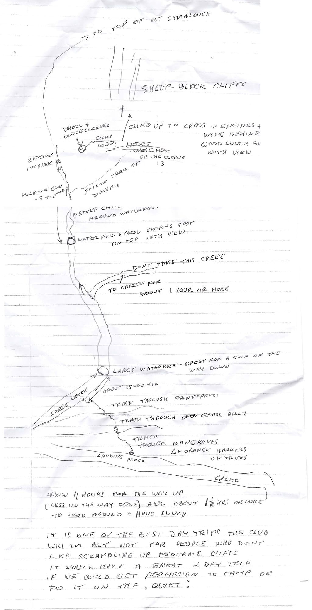
Up early, down to Dungess jetty at 6 am. Link up with the northern mob. Sandshoes on for the mud transit when we get off. Boat departed at 6:20 am, smooth early morning transit across the bay. Nice sunrise. Mt Straloch towers high, a daunting view when you look at how steep the slope up it is, and you can clearly see the creek line we will follow – straight up. Arrive at the drop off point in muddy mangrove Buff Creek, sandflies abound. Boat transit time was 25 minutes.
Climb out of the boat onto mangrove roots, slight challenge, then across through the mangroves and mud, mostly no more than ankle deep mud, then a soft patch up to shin deep. Phil the boat man led us through the mangroves to the boulder creek. The track through the mangroves and forest to the creek is marked, and easy fifteen minute walk. Arrived at the boulder creek at 7 am. Muddy sandshoes off, boots on. Final chat with Phil the boat man to confirm return timings and contact details in case of change. Creek was dry here, no water. Wilfred and Noel up front as route leaders, Keith at rear as tail end charlie, we are ready to go. 7:15 am start hiking up the creek, rock hopping over rocks and boulders, predominantly the creek is boulder strewn. After fifteen minutes pass small pools of water. At a pool (Alan’s swim hole ?), we are blocked so need to scrub bash on the left for a short distance. Ascent is only gradual for the first hour or so.
At the first creek junction, go left. Route is well marked at this point. Creek starts to get steeper and boulders larger. There is now trickling water readily available.
Very humid, we are all sweating profusely. For about two hours we clamber up the boulder strewn creek. But at a junction, main creek appears to go slight right, another creek on the left does not look substantial and is blocked by large tree. So we veer right and soon are blocked by large boulders and rock faces. Some cut their way through wait-a-while and vines, find stinging tree, so a few got stung on legs and hands. Others tried finding a way further right amongst huge boulders. After twenty minutes all link up again, but the way ahead looks rough and we keep getting blocked by boulders and rock face. We then decide we must be in the wrong creek, so turn back to the last junction. Go back down was easier and quicker. This side trip cost us 45 minutes.
At the junction, get past that fallen tree, then find markers, so head up this ‘left’ creek. Ascent becomes steeper. Soon a large rock face towers above, clamber up the right side, a very good lookout spot and time for smoko. Great views of the peaks to the sides, and down into the Lucinda channel, Herbert River, and Lucinda.
Short smoko, our leader keeps the group moving, no long smokos today. Climbing up the creek it gets steeper and steeper, on bare rock now with more reliable water flow. Some very steep rock faces and ledges to scramble up, testing those with short legs. Several of these choke points the group is slow to get through. Mt Stracloh still towers above, seemingly almost vertically above. Still looks a long way to go. Sweating profusely continues.
At 11:30 am we start to find wreckage in the creek. No sign of the machine gun marker (well, I did not see, but Glenys thinks they saw it), the sides of creek are heavily damaged by cyclone debris at this point. Noel advises this is the point to veer right and bush bash for the main wreckage. Keith goes up the creek a short way and finds the two engines in the creek, the rest explore to the side. We all leave the creek and cut across to the ledge, finding bits and pieces of wreckage. We find larger parts of the aircraft. Scramble up a scree like bit, get to the base of the rope climb (at 615 mr altitude), more substantial pieces of wreckage here. Steep slow climb using the rope, most go all the way up to the memorial cross, some don’t. Seven adventurers made it to the memorial cross at 650 mr altitude. Sheer high rock faces above, and Mt Stracloh still towers above at 925 mr.
A boulder is dislodged and this hurtles down the mountainside. Narrowly missed one walker near the memorial cross. The noise and sight was scary as it hurtled below and past opposite (by ten mr) those at bottom of the rope climb. Luckily Hans was no longer below in the path of the boulder. A close and unnerving call. Some of us aged ten years in that moment.
Climb back down the rope climb, a very slow and difficult process. Return to the creek, time was 1 pm, and leader says time to go. We had four hours to get down and meet the boat. Some had not had lunch yet. Nine walkers moved off with Keith. Two stayed behind with Wilfred for a quick bite to re-energise before moving on. We zoomed quickly down to reach the lookout rock and waited there for Wilfred and co to catch up. At this rate we would make very good time and maybe have a swim near the bottom. But, after this, we were slowed down by some steep rock faces, ledges or boulders we had to get down, and these proved very slow and difficult to transit. Lot of bum sliding going down, which saw many pants get torn. One, a lass from Ingham, ripped not only her trousers but the apparel underneath. Ok, being modest she hid at rear of the group. But we got to one rock face, which was difficult to get down. Wilfred found a way down, after being encouraged by Keith ‘go down this bit’. Keith stayed at the top to be the guide ! Wilfred got down, then looked up with doubtful look on his face. Well, gotta do it. We then called the Ingham lass to go down, hanging onto to thin branches for support as she blindly goes down the rock face (like abseiling but with tree branches). So down she goes exposing her bare rear to Wilfred – he was traumatised. Others tried a different route sliding down a rounded boulder face using vines. Using both routes we all got down, but that cost time. Further down were more slow points. But our leader keeps cajoling to keep moving on, breaks are kept short. ‘Push on’ was called a few times. There was enthusiasm for a bath in one of the lower rock pools, but time looked tight.
Finally the creek gradient started to flatten out somewhat, hopping along and through the boulders, we came to the rock pool but time was too tight to stop, so we zoomed past to reach the sandshoes and boulder creek exit point at 4:35 pm. Change shoes, at 4:45 pm our leader moved us out to head for the boat, planning to wait in the grass just before the mangroves and wait until hearing the boat. Waited there for five minutes, at 5 pm Wilfred goes off to see if the boat was there – Keith said it wouldn’t be. Minutes later Wilfred calls ‘boat is here’ – hmhmhmhmhm. So we trudge through the mud and mangroves and board the boat. Boat had been there for fifteen minutes ! Sandflies were viscous.
Phil the boat man asks ‘who would like a cold beer or soft drink?’ …. I turn and stare at him, what a cruel joke. But he seems genuine, so reply ‘love one’. Icy cold beers and soft drinks are passed around. Best beer I have had in ages !
Back in Dungeness at 5:25 pm. Wash mud off our shoes and legs, some try to bath using a hose in the park. Most then go to Lucinda for fish and chips, some straight back to TVL.
A great day trip. It was hard, but at the end of the day, a great sense of satisfaction in achieving what we planned. And timed to perfection !
Future Planning information:
Rated hard, strenuous. Very steep climb up the creek. Constant rock hopping, boulder clambering, negotiating rock faces and ledges. Not suitable for all walkers.
Boat capacity is 12 pax. Normal cost (2013) is $70 per pax. We got a discount for having full boat and paid $50 per pax. Boat transfer – Hinchinbrook Wilderness Safari – 4777 8307.
Need low tides – otherwise water may be above mangroves.
Need good dry conditions. August September would be good timing. Mid year and too much water in creek makes too hard to go up. October November might too hot, and not sure if the creek still flows then.
We took 4:50 minutes from time we got off the boat to reach wreckage in the creek. (From the creek point where we left sandshoes, took 4:15 hours. We lost 45 minutes up ‘mistake’ creek.) From the boat, allow 4 hours up and down, or 4.5 hours with a large group. Coming down we took 3hrs 35 minutes to get to our sandshoe spot, or 4 hrs to the boat (with short breaks only). Allow 1.5 hours at the wreck site to explore and have lunch – even then that is a rush.
Keep breaks short.
From Buff Creek to boulder creek – off boat through mangroves, grass land (swampish) and forest to boulder creek – allow fifteen minutes. Track is marked.
Mangroves and mud at start. Very steep climb up the creek. A few points need to scrub bash - wait-a-while, stinging tree, mozzies, midges.
Markers in mangroves – yellow on green.
Markers in creek – orange on black or pink tape.
Mobile phone reception on the slopes of Mt Straloch. No mobile reception at boat pick up point.
Sandshoes or similar recommended for transit of mangroves at start / finish. Leave sandshoes in the boulder creek gorge for return trip (no need to carry all day).
Need to have the boat depart at 6 am. Return time 5 pm.
Large group is slow at choke points. Small group would be faster.
Allow two hours to drive from Townsville to Lucinda.
To avoid the very early morning drive up from Townsville, overnight stay in Lucinda may be an attractive option. Accommodation options:
Lucinda Point Hotel – country pub / motel. 47778103
Wanderers Holiday Village – camping, or cabins. 4777 8213
Hinchinbrook Marine Cove Resort – motel, bungalows, apartments / units. 4777 8377
(Ingham to Lucinda, 25 km, allow 30 minute drive)
(Townsville to Lucinda 140 km, 1.75 hrs.)
Water – carry 2 lt. Refill from creek.


