Thornton Peak, The Hard Way
Thornton Peak, Cape Tribulation’s jagged giant, challenged climbers with clouds, boulder valleys, and rainforest in this 1984 ascent. After years of failed attempts, the summit was finally reached via the steep East Face—an epic North Queensland bushwalking and mountaineering achievement.
12-16th Sept. 1984
THORNTON PEAK, THE HARD WAY
"For the journey is done, and the summit attained, And barriers fall."
"Prospice" - Robert Browning.
Thornton Peak, over 4,500 (ft.), is a jagged-topped mountain standing well out on the bluff peninsula of Cape Tribulation, and, as a result, weatherwise, is the most fickle mist-spinner I have ever known, for, when the prevalent south-easter blows, it gives it a great orographic lift, right up from the sea, gathering dense cloud, often well down its flanks. It is usually climbed by a long 15 kms. route on the west side, but its East Face takes an enormous leap down to the beaches, though its map distance is only about 4 kms. Apart from a small patch of bracken and the summit rock ridge, the going is masked under thick bush, which, combined with map inaccuracies on the creeks, leaves position and direction in much doubt. But, a totally unexpected difficulty caused a recent deflection of route, of which, more anon.
But, let us look at a personal history of "having a go" at the East Face. 1971: Log Book record of ascent by West Ridge by members of Townsville Bushwalkers. 1972: seen by self from Port Douglas, and some realisation of how frequently it is under cloud. 1979: with Jillian - found "Thornton Creek" from Cooper Creek, but only to first boulders, as stones very wet and slippery.
1980: with Jillian, - imagining it a long day walk, - up Thornton Creek to Waterfalls; diverse to right up Rock Staircase.
1981: with Jillian - naively thought to top mountain from bivouac at foot of Waterfalls; up Rock Staircase, and long bush-bash, hopelessly misled by map, but discovered Bracken Patch, and, on descent, Rocky Gully. 1982: with Greg, camp above Waterfalls, northern traverse across Boulder Valley; down by Cooper Creek.
Sept., 1983; with Patrick; camp below Boulder Valley - no headway against immense boulders; realised expedition more than 3 days.
Oct., 1983, solo; new road, giving higher access to Thornton Creek; camp at Bracken Patch: thick bush up Boulder Ridge, then into valley; quite unexpectantly, no water! running underground through Boulder Valley! Retreat to surface issue of stream, therefore no high camp - too low to reach summit. July, 1984: with Richard, camp at Bracken Patch, began ascent of Boulder Ridge, but Mountain clouded over. August 1984, solo; traversed all across Boulder Valley, trying to find water - none!
Now, the lifestyle between these attempts is very pleasant - camping on the beach, sailing and canoeing along the coast and to the islands - the usual holiday beach living, but always with one eye on the Mountain, waiting for the cloud to clear. This is the greatest of all the difficulties - from my observations I conclude that the summit is clear only 20th to 40th of the time. All other quandaries can be tackled, but weather is out of our jurisdiction.
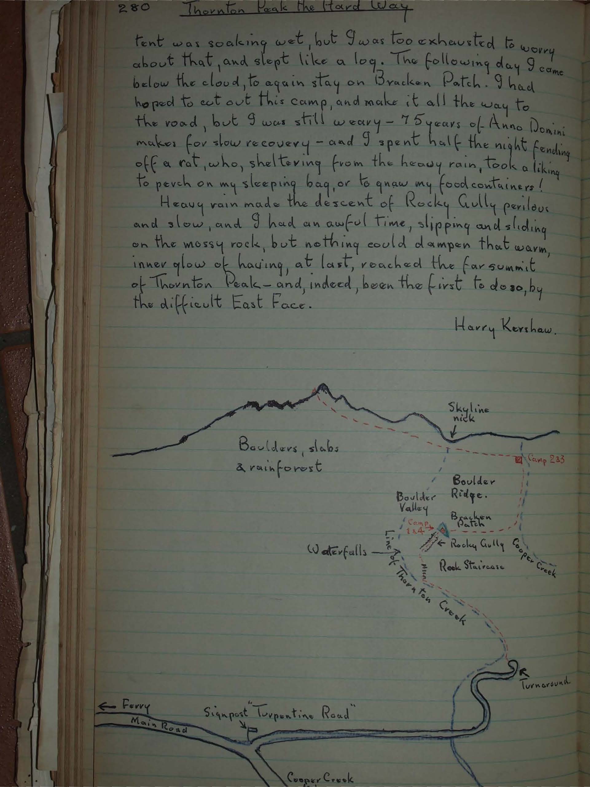
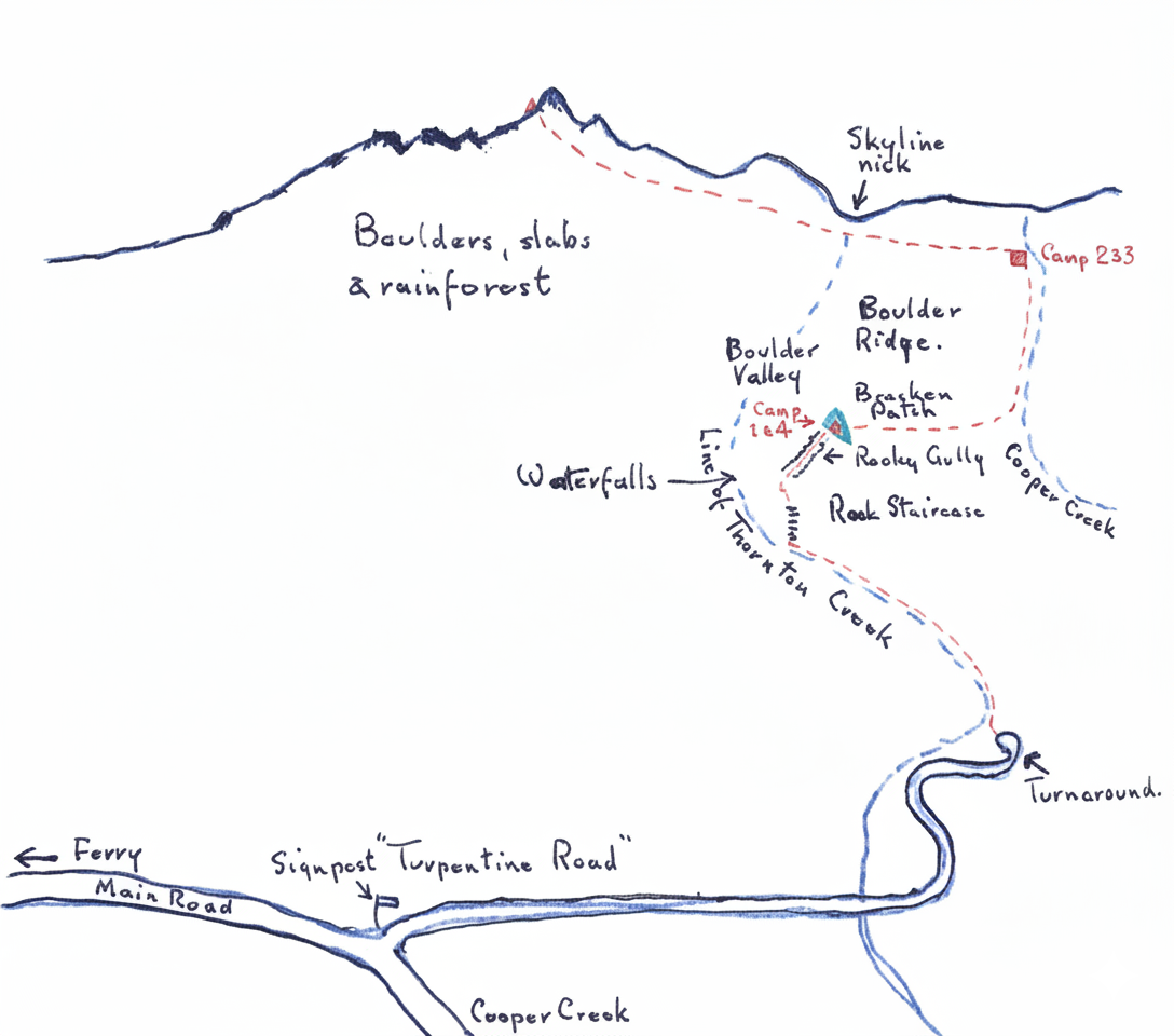
Leaving "Bessie" at the top turn-around of Turpentine Rd., I followed lovely Thornton Creek, easily the most scenic part of the trip, to the foot of the Waterfalls, (These cascades must be all of 1,000 ft. in height, and quite impossible to climb), crossed the stream near a huge fallen log, and ascended the steep Rock Staircase. Traversing across some small rock outcrops, I clambered up the second cleft, which is Rocky Gully. When this gully peters out, it leads to Bracken Patch. Just a few hectares, this is the only "window" on the mountain - all else is submerged in thick bush. (I did not take tent poles or pegs - just cut saplings, and tied the guy ropes to the vegetation, leaving the walls hanging.). As there is no surface water in Boulder Valley, I turned northwards into the headwaters of Cooper Creek, I turned following until it became a mere trickle, then put up top camp. I turned westward the next morning, still pushing through thick bush, until towering granite walls on either side ended in a steep chimney. A little scrambling and I was on the Summit Ridge! To the west was a blank wall of mist - I was at mist level, with the pointed, unclimbable highest peak on my right - the topmost rocks are immense chunks of granite. Quite suddenly, I saw, far below, the shining beaches and blue of Cooper Creeks entrance to the sea, and I waited half an hour - all the time I could spare - to take a picture, but, instead of thinning, the cloud increased to wooliness, and I had to be content to take one of the summit rock, and one of my equipment on the ridge.
The next problem was to find my bivouac, but, as I had wisely left a few newspaper and white cloth markers, that task was a little easier. The mist thickened and lowered - the Tent was soaking wet, but I was too exhausted to worry about that, and slept like a log. The following day I came below the cloud, to again stay on Bracken Patch. I had hoped to cut out this camp, and make it all the way to the road, but I was still weary - 75 years of Anno Domini makes for slow recovery - and I spent half the night fending off a rat, who, sheltering from the heavy rain, took a liking to perch on my sleeping bag, or to gnaw my food containers!
Heavy rain made the descent of Rocky Gully perilous and slow, and I had an awful time, slipping and sliding on the mossy rock, but nothing could dampen that warm, inner glow of having, at last, reached the far summit of Thornton Peak - and, indeed, been the first to do so, by the difficult East Face.
Harry Kershaw.