A bit of walk creation history
Discover the 2013 creation of the Blue Gum Creek circuit near Paluma, from wet-weather route planning and pink-tape marking to Mine Creek, wolfram mining relics, rainforest spurs, Triple Falls, swimming pools and upper Star River exploration history.
For many years (since 1960s), the club has explored Blue Gum Creek and Upper Star River area, another favourite bushwalking area.
Before Oct 2013, the Blue Gum Creek circuit track that we enjoy easily today did not exist. In previous years it was an unmarked walking area. So in Oct 2013 the club undertook to mark a route that would be easy to follow and suitable for wet conditions.
Blue Gum Creek area 20 Oct 13
Plan was an exploratory adventure up Big Crystal Creek, into the unknown. Maybe get as far as the base of Crystal Falls (too optimistic?).
Saturday, midnight, check weather radar, blob of colour indicating heavy rain right over the area we plan to walk in. At 2 am, check radar again (don’t ask why I am checking radar at ungodly hours), blob of colour still over that area indicating heavy rain continues.
At 6:15 am, a couple of us are engaged in phone conference discussing options, as the planned walk did not look achievable nor safe due to conditions. Weather forecast was for early showers also.
Blue Gum Creek area is suggested as alternate, for that route development idea. This is achievable if it rains or wet conditions, so we change the walk to Blue Gum Creek area.
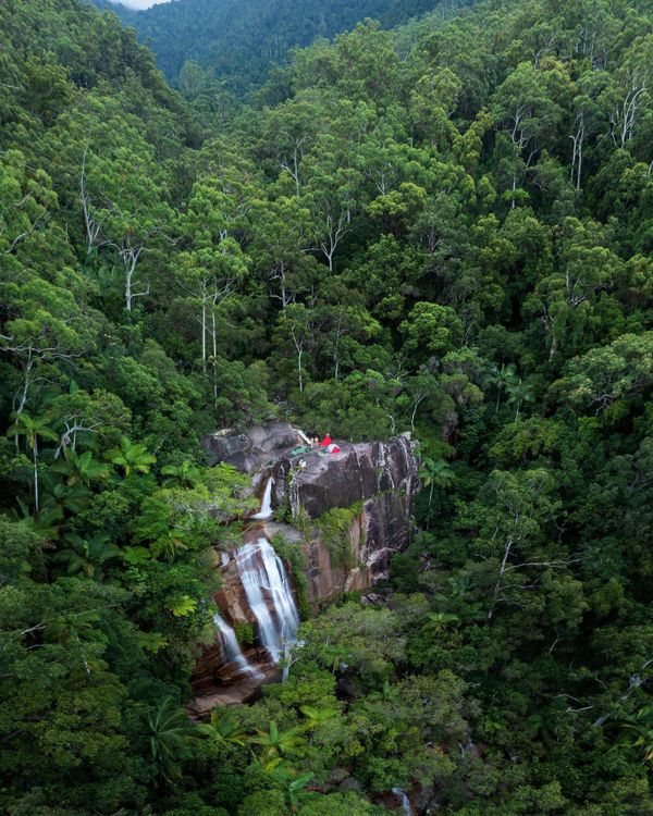
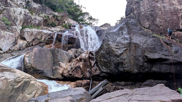
Five intrepid adventurers assemble at Paluma. Start walking 8:50 am, along the H Track and obtain a GPS Waypoint at the H Loop sign – the aim is to come out at this point at end of walk. Back onto Mt Spec Road and walk west for ten minutes, then left onto old formed track (old forestry road) that descends steeply in rainforest. Cross two small creeks. We traverse from rainforest through drier vegetation to grass trees and she-oaks. Reach the old wolfram mining area, observe crusher, artefacts, trenches, pits. This is where the formed track finished. Then downhill through grass trees to the nearby gorge and waterfalls for smoko at 10 am. Do not know name of this creek, but later it flows into Blue Gum Creek. Wilfred named it Mine Creek.
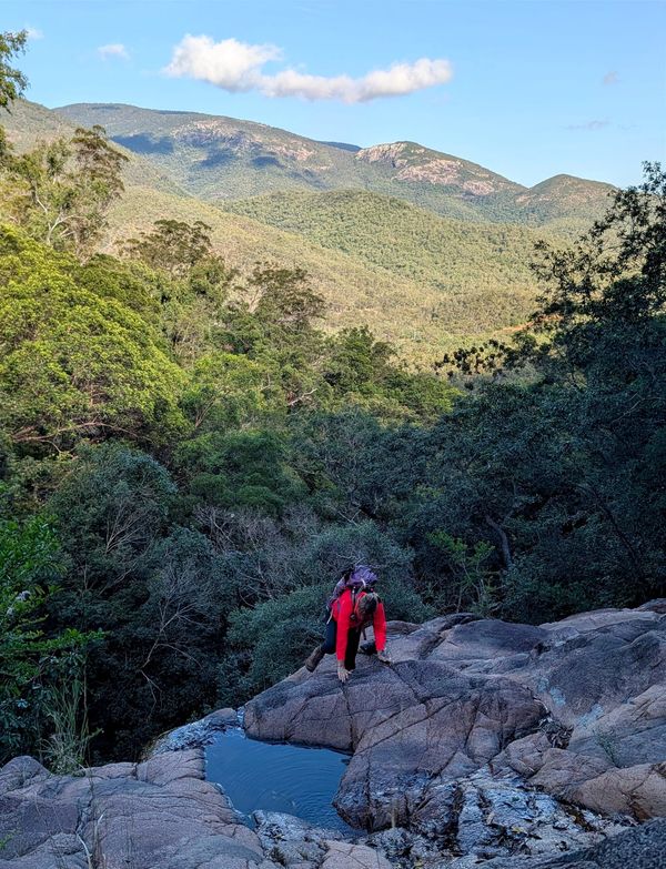
With Wilfred leading the way and bush bashing, two of the ladies at the rear with pink tape to mark where we have come from, we progress downhill parallel to but well above the creek line. The creek has some big drops in this area given how steeply down we traverse (the club came up this creek line in 2012 with Alan Watson). We re-join Mine Creek at the bottom where it flattens out. Then easy rock hopping 300 metres, past a nice creek coming in on the left (dam creek) and continue another 300 metres down to the junction of Blue Gum Creek. Find an old forestry marker on a tree at the junction. Lunch break at noon, in Blue Gum Creek. Country is drier woodland type vegetation down here. 400 mr descent to this point.
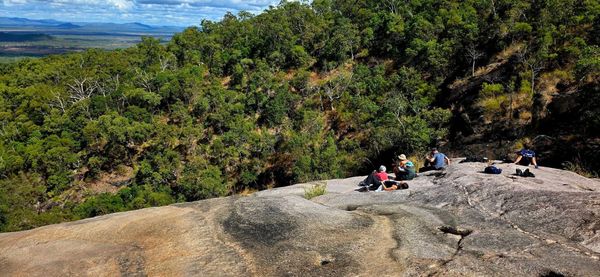
12:45 pm, from the creeks junction, we start the bush bash journey up the spur to head for Paluma and the waypoint on the H Track. There is some discussion about the 400 mr ascent and how steep that might be ! We climb the spur, Wilfred doing the hard yards up front, with two ladies at the back with pink tape. The ascent is constant but not real steep – well, one small section near the top was rather steeper. Views over Blue Gum Creek valley can be seen on the right to Star Valley. Might be able to find a good lookout point here with grand views. To the left is the deep gully that runs from Paluma (dam creek). Find another old forestry marker on a tree, LL. Later we find yet another
marker, H. Nearing the top, we get back to thick rainforest and traverse a mix of vegetation. Some of the ladies start to get cheeky (banter) with poor ole Wilfred– obviously they were doing it easy down the back! Under 1 km, to go, the excitement was building, open rainforest, easy going. 500 meters to go, still good. 300 metres to the waypoint, looking good, nice and easy. 200 metres to go, a dawdle. But then, multiple trees down (cyclone damage), our way is blocked. Keith (reading the GPSr) points ‘gotta go that way – direct !’. Groans are heard because that way was straight through the heart of the downed trees, wait-a-while, vines etc. Not deviation allowed !
‘Can’t we go around this scunge ?’ is the plea. ‘NO’. So the last 200 meters was a bit hard and slow (for Wilfred, the rest followed his trail blazing and did it easy). And at 3:45 pm, we arrive on the H Track exactly at the waypoint ! Love it when a plan comes together. Short fifteen minute walk along the national park H track, back to Paluma. Then freshen up ,and drive down the mountain to Frosty Mango for ice creams. An enjoyable day outing.
Blue Gum 27th Oct - route marking
A week later, we went back to mark the route properly and re-align a bit. Seven members participated in the route marking exercise. So now it is a marked route easily enjoyed.
At the bottom now we also go down Blue Gum Creek a short distance to a fantastic pool for a swim. Then on the ascent (if counter clockwise direction) we also now have the detour to Triple Falls, a highlight of the walk.
Side trip – on Mine Creek, there is a long sliding cascade and large pool that the track bypasses. If dry, you can follow from Mine Creek falls down the creek line, steep drops, to the long cascade slide and great pool, then follow the creek until it re-joins the marked route. Very scenic. We have used this route at times if conditions suit. You can also reach this with a short steep descent bush bash off the track.
An easy walk for fit bushwalkers. This route could be used as an access base for further exploring of the Blue Gum Creek and upper Star River area. There is always more exploring to do ..........
KD