Newsletter August 2019
Upcoming North Queensland walks, shares trip reports, map and gear updates, and bushwalking tips, from Mt Cleveland and Ethel Creek to digital topo maps and remote hiking tech.
G’day bushwalkers,
In this edition, the August 2019 newsletter, featured are future walks, walk reports from July/August, and other information.
Future Walks
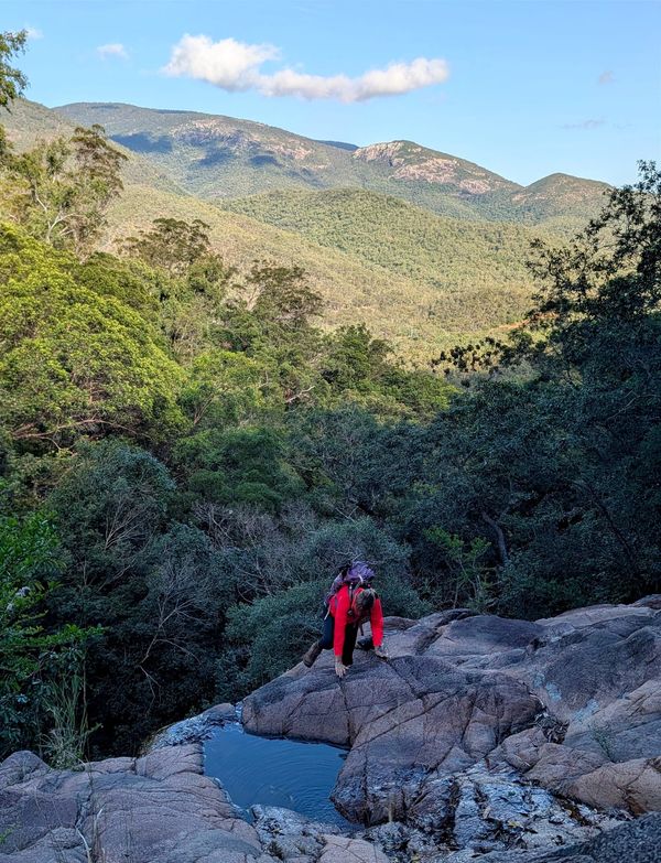
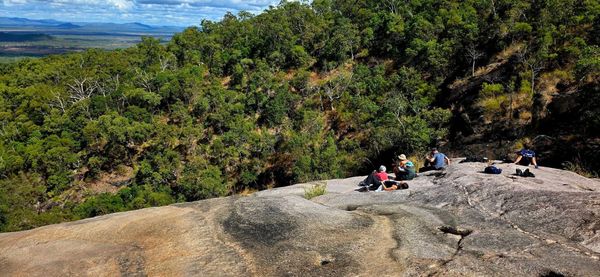
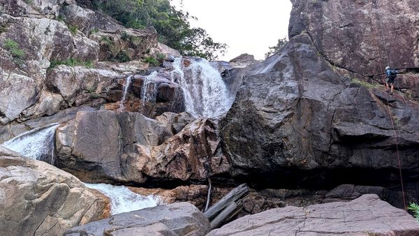
We will aim to run a walk every weekend where possible during August and September, subject to walk leader availability. At the monthly meetings in August and September we will schedule walks for the next four weeks. To register for one of the walks or get more info, come along to the meetings. Some walks may be restricted in numbers, so being a member and also at the meeting to register for walk(s) will be advantageous. Walks being considered include Return / Narke; Bullocky Tom’s Creek; Godwin / Halifax; Five Beaches bay; Little Crystal Creek; Cape Cleveland – Western Ridge and or Mt Cleveland; Slippery Rocks Creek; Crystal Creek Falls bottom; and Hencamp Creek.
October we may revert back to fortnightly walks.
Next Walks
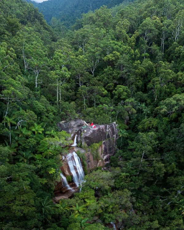
18th August Sunday – one day walk – Mt Cleveland. Leader Luen
25th August Sunday – one day walk – Ethel Creek through walk. Leader Phil
1st September Sunday - one day walk – Bullocky Toms Creek. Leader Keith
8th September – Sunday one day walk – Slippery Rocks creek exploratory. Leader Wilfred / Keith
Next meeting – Monday 9th September at 6 pm at the meeting room.
Walk Registration
Registering for a walk – intending walkers must register with the walk leader and obtain briefing and approval to attend a walk, either at the meeting or by phone. Do not email the club as that may be missed and will not be accepted!
Reminder that walker registration will not be accepted if the leader believes that the walk is unsuitable for you.
Visitors who have not walked with the club before must attend a monthly meeting before participating in a walk.
Membership
We are often asked by new walkers how do they become a member. The club rules are to complete three qualifying walks first, then apply for membership, cost $40. After three walks it is mandatory to join the club (subject to membership application being accepted by the committee). It is a condition of the bushwalking insurance policy that covers the club that membership is mandatory after three walks.
Ravings from Recent Walks
Terraces, Waterview Creek, Cape Cleveland and Waterfall Creek – link to ravings from those walks. https://1drv.ms/u/s!ArMwYAvY477chCXlLA__f-1ixJiK?e=fOyUVQ
West McDonnell Ranges including Larapinta Trail – link to ravings from a 298 km 18 day walk that four members did in June / July. https://1drv.ms/u/s!ArMwYAvY477cgmOO3PyoNZMWeTpz?e=HJsaCr
Phil (Secretary) has taken over as the club Facebook page admin/coord. We sincerely thank Katherine for her great work in setting Facebook up and performing admin/coord to date.
Future of Maps
I like printed topographic maps. But these are being phased out by Commonwealth and state agencies. The future is digital downloads, and print your own map or use a smart device.
Geoscience Australia’s printed maps are being phased out. Interactive web maps are now available to assist with discovery and download of the topographic map series. These are available for 1:50 000, 1:100 000, 1:250 000 and 1:1 million scale published topographic maps. Use Google Chrome to view these maps. http://www.ga.gov.au/scientific-topics/national-location-information/topographic-maps-data/topographic-maps It is easy to download a map as a TIFF file, which you can print yourself or load to smart device. You can geo-ref the map to have live mapping / tracking on your smart device too. Some of us have Mt Spec, Paluma and Mt Elliot topographic maps geo-ref’d and loaded to our smart phones for live mapping.
QLD - The Queensland Government no longer sells printed copies of topographic maps. With QTopo, you can view Queensland's topography online and download maps as PDFs or PNG files. The maps you download from QTopo contain the same information as traditional printed maps, and you can print these on a local printer or at a print shop. http://qtopo.dnrm.qld.gov.au/mobile/
Is QTOPO good compared to the printed topographic maps ? It does not show all the detail from the old printed maps – e.g. rocky outcrops, peaks or cliff lines. One of reasons the old topo maps stopped being produced was the time involved in created a single 1:25000 line map was a bit prohibitive. The reason we've been able to "resurrect" topo maps with QTopo is that we've been able to use state-wide datasets to create maps over the entire state. Unfortunately cutting out sections of contours for cliff lines and picking out rocky outcrops was manual work which was possible in the old school way of doing things, but not so much in the automated world we're operating in.
Other states have also gone online and digital – e.g. NSW - https://maps.six.nsw.gov.au/ . Also if you have the Avenza map on your smart phone, you can purchase NSW topo maps through that app and they are already geo-ref for live mapping while you hike using Avenza. TAS - https://maps.thelist.tas.gov.au/listmap/app/list/map
There are also other means of digital mapping for bushwalking, e.g. OSM, or other apps. So the future is online digital. If you like the “old” printed topographic maps, get them while you can from your map retailer.
Other Interest
31 August – Bowen Lighthouse Walk (not a club event). The annual community walk to Bowen lighthouse that is only held once per year on a very low tide. The 2019 Walk to the Lighthouse is scheduled for the Saturday 31st August. Low tide is 0.18M at 4:32. Refer https://www.tourismbowen.com.au/see-do/whats-on/walk-to-the-lighthouse . If you go down, you can also do a nice coastal walk at Bowen. The day before, Friday, around 1530 is an even lower tide and would be good time to walk over to the lighthouse without the crowd.
For other local walking and adventures, keep an eye on Wanderstories https://wanderstories.space/ and LetsWalk Townsville https://www.meetup.com/en-AU/LetsWalkTownsville/ . They do some good activities, including midweek.
Techno Babble
Do you carry lot of nav and comms gear ? Garmin have released the new GPSMAP 66i Handheld GPS and Satellite Communicator with Topo Mapping, which combines GPSr with Inreach in one unit. So in theory you could replace satellite phone/Spot/Inreach, PLB, and GPSr with one device. - combine the inReach satellite communication technology, with their flagship handheld GPS for outdoor enthusiasts. This product realises this dream, by combining the world's most capable handheld GPS, with the best satellite communication technology available. Once subscribed to a competitively priced plan, the GPSMAP 66i turns into a powerful communication device that can work off the grid, anywhere in the world. Because it communicates in 2 directions, it can send AND receive messages to any email address, or standard mobile phone number. If the worst comes to worst, you can trigger an SOS alert and communicate with GEOS search and rescue monitoring centre. Will be interesting to see the detail and reviews of this product, especially the SOS functionality compared to PLB (my initial thinking is that PLB is direct to Australian authorities, whilst Inreach/66i SOS goes to USA first).
Bushwalking Food
We are all familiar with freeze-dried meals and the Back Country brand. There are many thoughts on the likeability of these, from good to dislike. Did you know you can get freeze-dried scrambled egg meal in a 125gram pouch (just add hot water) from another NZ company (online)? (eggs, bacon, and chives in a zesty hollandaise sauce). I tried it during the Larapinta walk – not bad, though not cafe gourmet or home cooked quality (seems bit dry / overcooked when reconstituted – maybe needs more water ?), but good enough for remote bushwalking and a change from the usual bushwalking breakfast. It is a huge serve though, high Kj, over 3,000 kj per meal, very filling, so sets you up with energy for the day. Oh, and they have a freeze-dried Mocha Rice Pudding for dessert for a bit of decadence after a hard days hiking.
Trivia
If you lose visual contact “Hey Bob” is the accepted bushwalking call in bushwalking clubs in Australia. Where did “Hey Bob” originate ? No-one seems sure, but it rolls of the tongue easily, and having a standardised call reduces confusion.